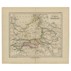
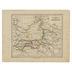
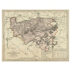
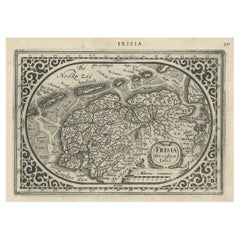
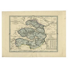
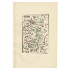
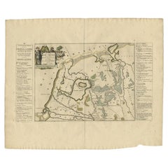
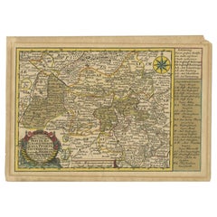
Antique Map of Gelderland with the Veluwe Etc, the Netherlands, 1864
Located in Langweer, NL
We offer a wide range of authentic antique maps for any budget.
Category
19th Century Authentic Antique Maps
Materials
Paper
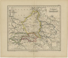
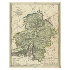
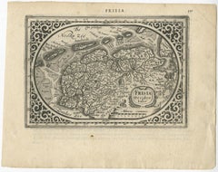
Antique Map of Gelderland with the Veluwe Etc, the Netherlands, 1864
Located in Langweer, NL
We offer a wide range of authentic antique maps for any budget.
Paper
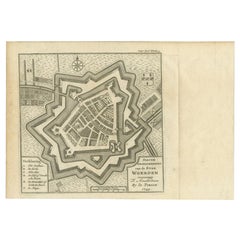

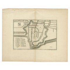
Antique Map of the City of Woerden by Tirion, c.1750
Located in Langweer, NL
We offer a wide range of authentic antique maps for any budget
Paper
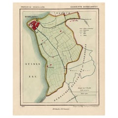

Antique Map of Hindelopen, Picturesque Harbour City in Friesland, Holland, 1868
Located in Langweer, NL
We offer a wide range of authentic antique maps for any budget.
Paper

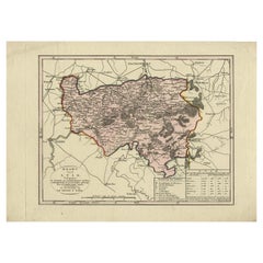
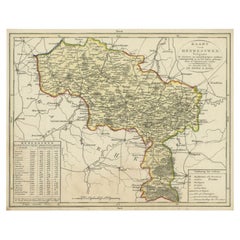
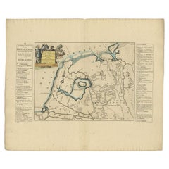
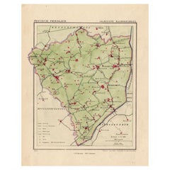
Antique Map of Gelderland, Largest Province of The Netherlands, c.1870
Located in Langweer, NL
We offer a wide range of authentic antique maps for any budget.
Paper

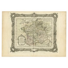
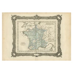
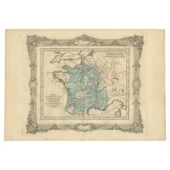
Antique Map of France in the 5th Century by Zannoni, 1765
Located in Langweer, NL
We offer a wide range of authentic antique maps for any budget.
Paper
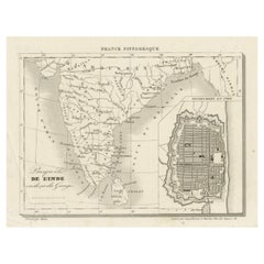
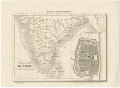
French Antique Map of India with an Inset of Pondicherry, 1835
Located in Langweer, NL
We offer a wide range of authentic antique maps for any budget.
Paper
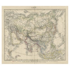
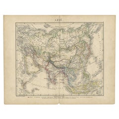
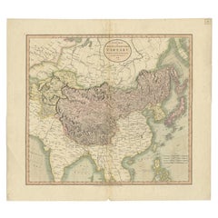
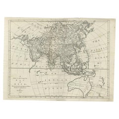
Antique Map of Asia Showing the European Language Areas, c.1873
Located in Langweer, NL
We offer a wide range of authentic antique maps for any budget.
Paper
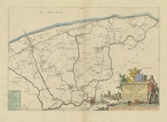
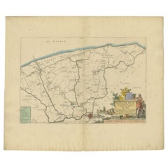
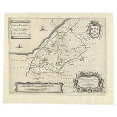
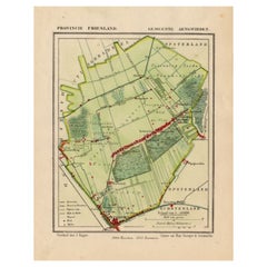
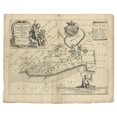
Antique Map of the Dongeradeel Township in Friesland, The Netherlands, 1718
Located in Langweer, NL
We offer a wide range of authentic antique maps for any budget.
Paper
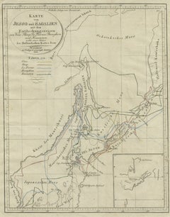
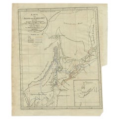
Antique Map of the Region of Hokkaido, Island of Japan, 1812
Located in Langweer, NL
We offer a wide range of authentic antique maps for any budget.
Paper

Antique Map of the Region of Luik by Veelwaard, c.1840
Located in Langweer, NL
We offer a wide range of authentic antique maps for any budget.
Paper

Antique Map of the Region of Namur by De Lat, 1737
Located in Langweer, NL
We offer a wide range of authentic antique maps for any budget.
Paper

Antique Map of the Region of Luik by Veelwaard, C.1840
Located in Langweer, NL
We offer a wide range of authentic antique maps for any budget.
Paper

Antique Map of the Region of Namen by Veelwaard, c.1840
Located in Langweer, NL
We offer a wide range of authentic antique maps for any budget.
Paper

Antique Map of the Region of Henegouwen by Veelwaard, C.1840
Located in Langweer, NL
We offer a wide range of authentic antique maps for any budget.
Paper

Antique Map of the County of Bentheim by Hondius, c.1630
Located in Langweer, NL
We offer a wide range of authentic antique maps for any budget.
Paper

Antique Map of the Coast of Kerguelens Island by Cook, 1803
Located in Langweer, NL
We offer a wide range of authentic antique maps for any budget.
Paper
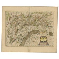
Antique Map of Friesland and Groningen, Provinces of the Netherlands, 1628
Located in Langweer, NL
We offer a wide range of authentic antique maps for any budget.
Paper


$511Sale Price|20% Off
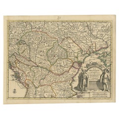
Antique Map of Hungary Incl Surroundings like Croatia, Bosnia, Servia, 1730
Located in Langweer, NL
We offer a wide range of authentic antique maps for any budget.
Paper

Antique Map of France in the 7th Century by Zannoni, 1765
Located in Langweer, NL
We offer a wide range of authentic antique maps for any budget.
Paper

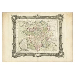
Antique Map of France under the Reign of Francois II, 1765
Located in Langweer, NL
We offer a wide range of authentic antique maps for any budget.
Paper
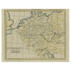

Antique Map of Germany from an Old English Atlas, c.1802
Located in Langweer, NL
We offer a wide range of authentic antique maps for any budget.
Paper

Antique Map of the Gulf of Tomini by Winkler Prins, 1878
Located in Langweer, NL
We offer a wide range of authentic antique maps for any budget.
Paper
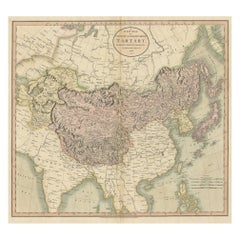
Antique Map of Chinese and Independent Tartary, Korea and Japan, 1806
Located in Langweer, NL
We offer a wide range of authentic antique maps for any budget.
Paper

Antique Map of the City of Harlingen by Merian, c.1655
Located in Langweer, NL
We offer a wide range of authentic antique maps for any budget.
Paper

Antique Map of the Province of Zeeland by Veelwaard, C.1840
Located in Langweer, NL
We offer a wide range of authentic antique maps for any budget.
Paper

Antique Map of the Old Lands of Friesland by Halma, 1718
Located in Langweer, NL
We offer a wide range of authentic antique maps for any budget.
Paper

Antique Map of the Region of Wijhe-Diepenveen by Craandijk, 1884
Located in Langweer, NL
We offer a wide range of authentic antique maps for any budget.
Paper

Antique Map of the Region of Ferwerderadeel in The Netherlands, 1664
Located in Langweer, NL
We offer a wide range of authentic antique maps for any budget.
Paper
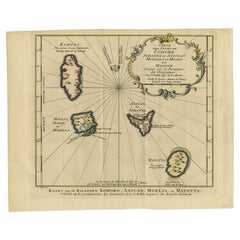
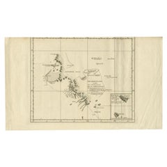
Antique Map of the Main Comoro Islands by Van Schley, 1749
By Jakob van der Schley
Located in Langweer, NL
We offer a wide range of authentic antique maps for any budget
Paper

Antique Map of the Old Lands of FriesLand by Halma, 1718
Located in Langweer, NL
We offer a wide range of authentic antique maps for any budget.
Paper

$111Sale Price|20% Off
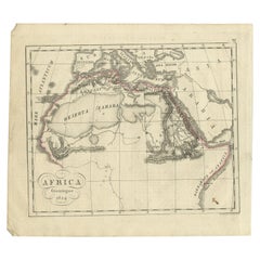
Antique Map of Northern Africa from a Rare Dutch Atlas, 1825
Located in Langweer, NL
We offer a wide range of authentic antique maps for any budget.
Paper
Antique Map of France under the Reign of Francois I, 1765
Located in Langweer, NL
We offer a wide range of authentic antique maps for any budget.
Paper
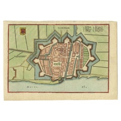

Antique Map of the City of Gorinchem by Merian, c.1659
Located in Langweer, NL
We offer a wide range of authentic antique maps for any budget.
Paper

Antique Map of Asia and Australia with a Speculative Coastline, 1777
Located in Langweer, NL
We offer a wide range of authentic antique maps for any budget.
Paper

$167Sale Price|20% Off
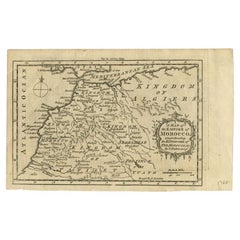
Antique Map of the Empire of Morocco by Kitchin, c.1760
By Thomas Kitchin
Located in Langweer, NL
We offer a wide range of authentic antique maps for any budget.
Paper


Antique Map of the Maluku Islands by Van der Aa, 1714
By Pieter Van Der Aa
Located in Langweer, NL
We offer a wide range of authentic antique maps for any budget
Paper
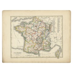

Antique Map of France from an Old Dutch School Atlas, 1852
Located in Langweer, NL
We offer a wide range of authentic antique maps for any budget.
Paper
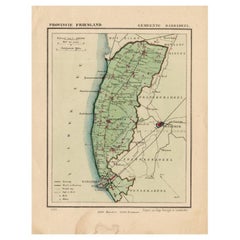

Antique Map of Barradeel, a County in Friesland, The Netherlands, 1868
Located in Langweer, NL
We offer a wide range of authentic antique maps for any budget.
Paper

Antique Map of Ferwerderadeel, a County in Friesland, The Netherlands, 1868
Located in Langweer, NL
We offer a wide range of authentic antique maps for any budget.
Paper

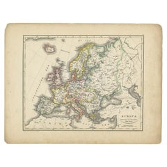
Antique Map of Europe from an Old Dutch School-Atlas, 1852
Located in Langweer, NL
We offer a wide range of authentic antique maps for any budget.
Paper
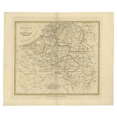

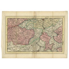
Antique Map of Belgium and Part of the Southern Netherlands, 1810
Located in Langweer, NL
We offer a wide range of authentic antique maps for any budget.
Paper

Antique Map of Frisian Township of Baarderadeel in the Netherlands, 1868
Located in Langweer, NL
We offer a wide range of authentic antique maps for any budget.
Paper

$120Sale Price|20% Off
Antique Map of Frisian Municipality of Aengwirden in the Netherlands, 1868
Located in Langweer, NL
We offer a wide range of authentic antique maps for any budget.
Paper

$82Sale Price|49% Off
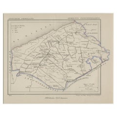
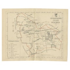
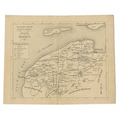
Antique Map of the Frisian Tietjerksteradeel Township in the Netherlands, 1861
Located in Langweer, NL
We offer a wide range of authentic antique maps for any budget.
Paper

Antique Map of the Region of Fulda by Homann, c.1730
Located in Langweer, NL
We offer a wide range of authentic antique maps for any budget.
Paper

$139Sale Price|20% Off
Antique Dutch Map of The Region of Leeuwarden by Behrns, 1861
Located in Langweer, NL
We offer a wide range of authentic antique maps for any budget.
Paper

$82Sale Price|64% Off
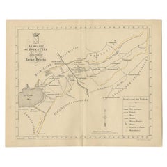
Antique Map of the Schoterland Township in Friesland, the Netherlands, 1861
Located in Langweer, NL
We offer a wide range of authentic antique maps for any budget.
Paper
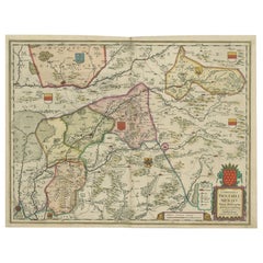
Antique Map of the Region of Roermond by Janssonius, c.1650
By Johannes Janssonius
Located in Langweer, NL
We offer a wide range of authentic antique maps for any budget.
Paper


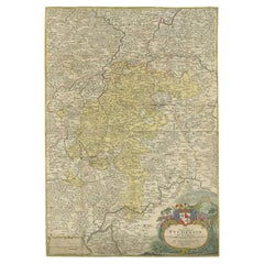
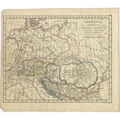
Antique Map of Germany of German in Roman Times, c.1660
Located in Langweer, NL
We offer a wide range of authentic antique maps for any budget.
Paper

Rare Antique Map of the Region of Freyburg in Germany, 1749
By Schreiber
Located in Langweer, NL
We offer a wide range of authentic antique maps for any budget.
Paper
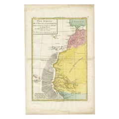

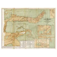
Antique Map of the Coast of Northwest Africa by Dien, 1820
Located in Langweer, NL
We offer a wide range of authentic antique maps for any budget
Paper
Antique Map of the Region of Gaasterland, Friesland, The Netherlands, 1664
Located in Langweer, NL
We offer a wide range of authentic antique maps for any budget.
Paper
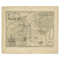

Antique Map of the Region of Cambrai in France, c.1630
Located in Langweer, NL
We offer a wide range of authentic antique maps for any budget.
Paper
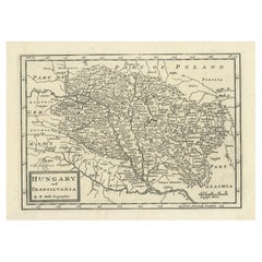
Antique Engraved Map of Hungary and Transylvania or Romania, c.1710
Located in Langweer, NL
We offer a wide range of authentic antique maps for any budget.
Paper

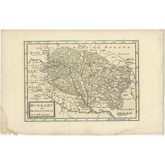
Antique French Map of Hungary with Decorative Title Cartouche, c.1730
Located in Langweer, NL
We offer a wide range of authentic antique maps for any budget.
Paper

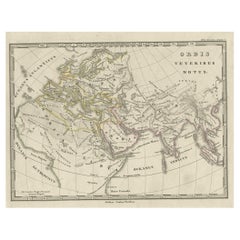
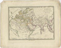
Antique Map of Germany in Roman Times, Showing Roman Provinces, 1825
Located in Langweer, NL
We offer a wide range of authentic antique maps for any budget.
Paper
Antique Map of Europe and Part of Asia and Africa, 1848
Located in Langweer, NL
We offer a wide range of authentic antique maps for any budget.
Paper