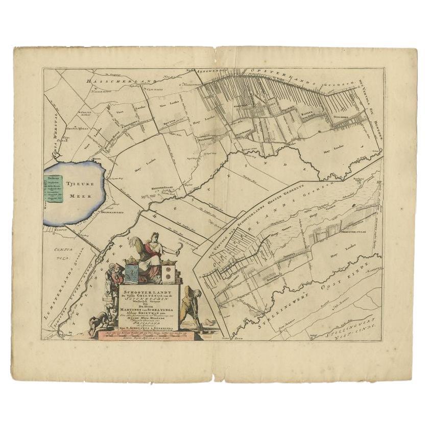
Items Similar to Antique Map of the Schoterland Township in Friesland, the Netherlands, 1861
Want more images or videos?
Request additional images or videos from the seller
1 of 5
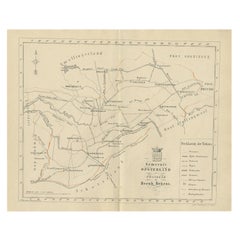
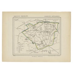
Antique Map of the Schoterland Township in Friesland, the Netherlands, 1861
About the Item
Antique map titled 'Gemeente Schoterland'. Old map depicting the Schoterland township including cities and villages like Rotsterhaule, Delfstrahuizen, Nieuweschoot, Mildam, Katlijk, Oudeschoot, Oranjewoud and Nieuwehorne. This map orginates from 'Zak-Atlas van Friesland in 36 Kaarten'.
Artists and Engravers: Published by B. Behrns, Franeker.
Condition: Good, general age-related toning. Please study image carefully.
Date: 1861
Overall size: 21.1 x 17.2 cm.
Image size: 0.001 x 18.5 x 15.3 cm.
We sell original antique maps to collectors, historians, educators and interior decorators all over the world. Our collection includes a wide range of authentic antique maps from the 16th to the 20th centuries. Buying and collecting antique maps is a tradition that goes back hundreds of years. Antique maps have proved a richly rewarding investment over the past decade, thanks to a growing appreciation of their unique historical appeal. Today the decorative qualities of antique maps are widely recognized by interior designers who appreciate their beauty and design flexibility. Depending on the individual map, presentation, and context, a rare or antique map can be modern, traditional, abstract, figurative, serious or whimsical. We offer a wide range of authentic antique maps for any budget.
- Dimensions:Height: 6.78 in (17.2 cm)Width: 8.31 in (21.1 cm)Depth: 0 in (0.01 mm)
- Materials and Techniques:
- Period:
- Date of Manufacture:1861
- Condition:
- Seller Location:Langweer, NL
- Reference Number:
About the Seller
5.0
Platinum Seller
These expertly vetted sellers are 1stDibs' most experienced sellers and are rated highest by our customers.
Established in 2009
1stDibs seller since 2017
1,957 sales on 1stDibs
Typical response time: <1 hour
- ShippingRetrieving quote...Ships From: Langweer, Netherlands
- Return PolicyA return for this item may be initiated within 14 days of delivery.
More From This SellerView All
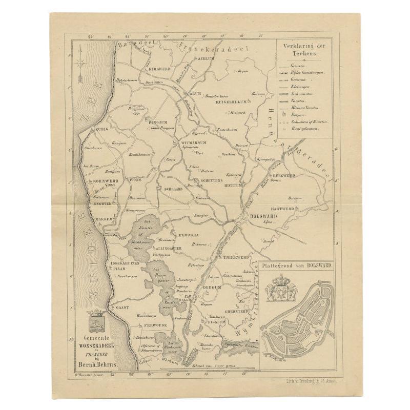
- Antique Map of The Wonseradeel Township in Friesland, The Netherlands, 1861Located in Langweer, NLAntique map titled 'Gemeente Wonseradeel'. Old map depicting the Wonseradeel township including cities and villages like Kimswerd, Achlum, Arum, Witmarsum, Kornwerd, Hichtum and Bols...Category
Antique 19th Century Maps
MaterialsPaper
- Antique Map of the Schoterland Township, Friesland by Halma, 1718Located in Langweer, NLAntique map Friesland titled 'Schooterlandt de Vijfde Grietenije van de Sevenwolden (..)'. Old map of Friesland, the Netherlands. This map depicts the region of Schoterland and inclu...Category
Antique 18th Century Maps
MaterialsPaper
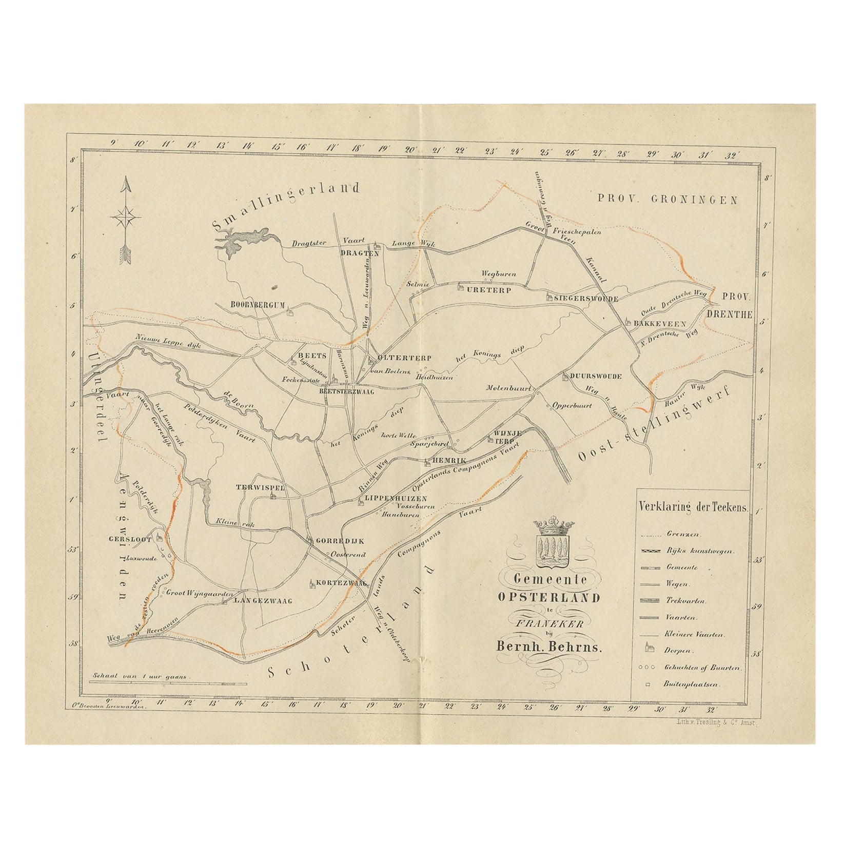
- Antique Dutch Map of The Opsterland Township in Friesland, 1861Located in Langweer, NLAntique map titled 'Gemeente Opsterland'. Old map depicting the Opsterland township including cities and villages like Boornbergum, Beets, Olterterp, Terwispel, Lippenhuizen, Gorredi...Category
Antique 19th Century Maps
MaterialsPaper
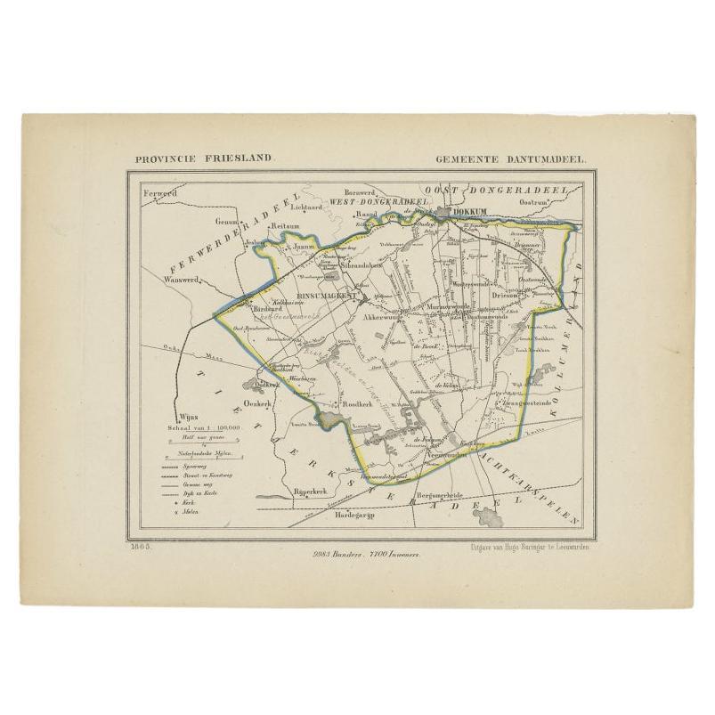
- Antique Map of Dantumadeel, a Township in Friesland, The Netherlands, 1868Located in Langweer, NLAntique map titled 'Provincie Friesland - Gemeente Dantumadeel'. Map of the township of Dantumadeel including Birdaard, Rinsumageest, Veenwouden and many other villages. This map ori...Category
Antique 19th Century Maps
MaterialsPaper
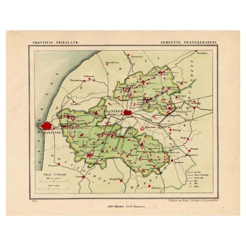
- Antique Map of Franekeradeel, Township in Friesland, The Netherlands, 1868Located in Langweer, NLAntique map titled 'Provincie Friesland - Gemeente Franekeradeel'. Map of the township of Franekeradeel including Franeker, Achlum, Dongjum, Midlum and many other villages. This ...Category
Antique 19th Century Maps
MaterialsPaper
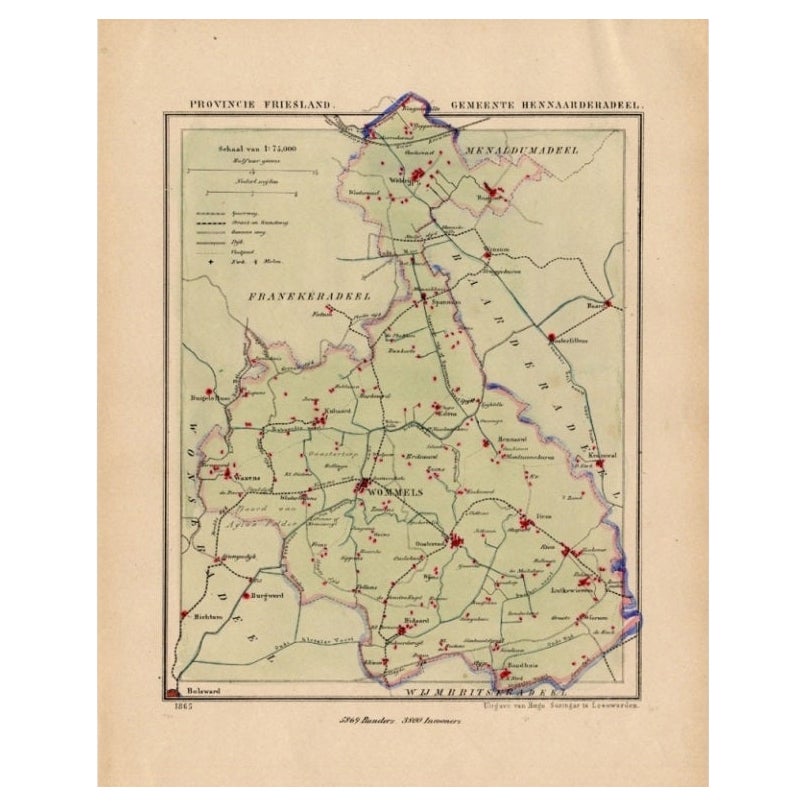
- Antique Map of Hennaarderadeel, Township in Friesland, The Netherlands, 1868Located in Langweer, NLAntique map titled 'Provincie Friesland - Gemeente Hennaarderadeel'. Map of the township of Hennarderadeel including Oosterend, Wommels and many other villages. This map originat...Category
Antique 19th Century Maps
MaterialsPaper


You May Also Like
- 1861 Topographical Map of the District of Columbia, by Boschke, Antique MapLocated in Colorado Springs, COPresented is an original map of Albert Boschke's extremely sought-after "Topographical Map of the District of Columbia Surveyed in the Years 1856 ...Category
Antique 1860s American Historical Memorabilia
MaterialsPaper
- Original Antique Map of Indonesia, 1861Located in St Annes, LancashireGreat map of Indonesia Drawn and engraved by Edward Weller Original color Published in The Weekly Dispatch Atlas, 1861 Repairs to minor e...Category
Antique 1860s English Victorian Maps
MaterialsPaper

- Original Antique Map of The Netherlands, Engraved by Barlow, Dated 1807Located in St Annes, LancashireGreat map of Netherlands Copper-plate engraving by Barlow Published by Brightly & Kinnersly, Bungay, Suffolk. Dated 1807 Unframed.Category
Antique Early 1800s English Maps
MaterialsPaper
- Original Antique Map of The Netherlands, Sherwood, Neely & Jones, Dated 1809Located in St Annes, LancashireGreat map of The Netherlands Copper-plate engraving by Cooper Published by Sherwood, Neely & Jones. Dated 1809 Unframed.Category
Antique Early 1800s English Maps
MaterialsPaper
- Original Large Antique Map of Paris, France by John Dower, 1861Located in St Annes, LancashireFabulous monochrome map of Paris. Vignettes of St Germain En Laye, Saint Cloud, Versailles and Fontainbleau. Unframed. Drawn by J.Dower. Lithography by Weller. 4 sheets j...Category
Antique 1860s English Victorian Maps
MaterialsPaper
- School Chart or Pull Down Map of Geography of the Netherlands, 1950sLocated in Hemiksem, VANA beautiful old school map of the Netherlands, painted on linen. The map shows the 3 different reliefs (low, middle, high) of the Netherlands. The beau...Category
Vintage 1950s Belgian Mid-Century Modern Maps
MaterialsLinen, Paint


Recently Viewed
View AllMore Ways To Browse
Antique The Netherlands
Antique Old Map Of The World
Netherlands Antique Map
Zak Designs
Globe Map
Map Globe
Framed Antique Map
Jacques Antiques
Africa Map
Maps Of Africa
Large Metal Cross
Map Of Africa
Antique German Map
Antique German Maps
Antique Map Germany
Antique Maps Germany
Antique Collectible Market
Antique Collectable Market