Items Similar to Antique Engraved Map of Hungary and Transylvania or Romania, c.1710


Want more images or videos?
Request additional images or videos from the seller
1 of 6
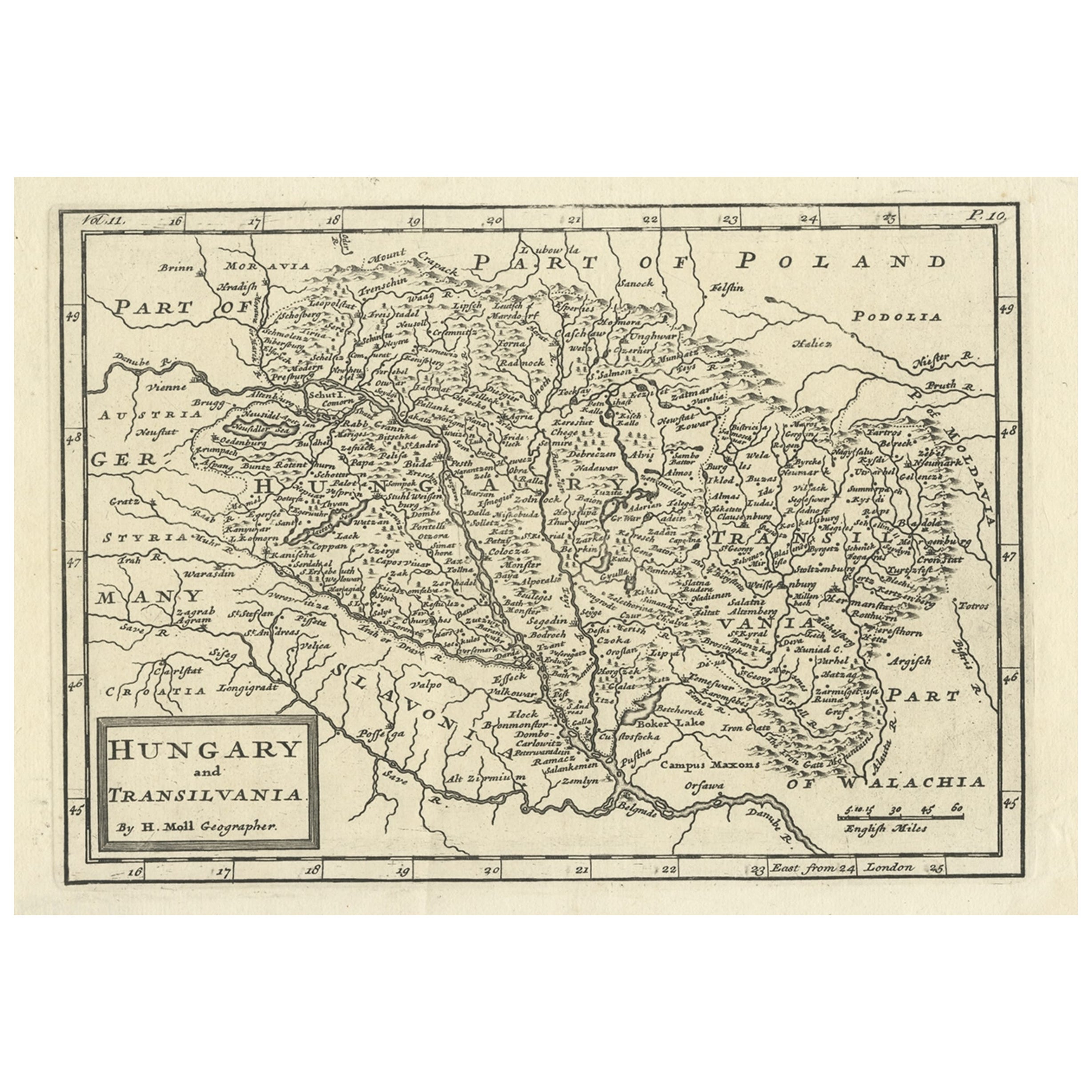
Antique Engraved Map of Hungary and Transylvania or Romania, c.1710
About the Item
Antique map titled 'Hungary and Transilvania'. Original antique map of Hungary and Transylvania (modern day Romania), centered on Budapest. Artists and Engravers: Herman Moll (1654 - 1732), was a London cartographer, engraver and publisher.
Artist: Herman Moll (1654 - 1732), was a London cartographer, engraver and publisher.
Condition: Good, stain outside image. Minor defects, please study image carefully.
Date: c.1710
Overall size: 36.5 x 24 cm.
Image size: 26 x 18 cm.
We sell original antique maps to collectors, historians, educators and interior decorators all over the world. Our collection includes a wide range of authentic antique maps from the 16th to the 20th centuries. Buying and collecting antique maps is a tradition that goes back hundreds of years. Antique maps have proved a richly rewarding investment over the past decade, thanks to a growing appreciation of their unique historical appeal. Today the decorative qualities of antique maps are widely recognized by interior designers who appreciate their beauty and design flexibility. Depending on the individual map, presentation, and context, a rare or antique map can be modern, traditional, abstract, figurative, serious or whimsical. We offer a wide range of authentic antique maps for any budget.
- Dimensions:Height: 14.38 in (36.5 cm)Width: 9.45 in (24 cm)Depth: 0 in (0.01 mm)
- Materials and Techniques:
- Period:
- Date of Manufacture:circa 1710
- Condition:
- Seller Location:Langweer, NL
- Reference Number:
About the Seller
5.0
Platinum Seller
These expertly vetted sellers are 1stDibs' most experienced sellers and are rated highest by our customers.
Established in 2009
1stDibs seller since 2017
1,929 sales on 1stDibs
Typical response time: <1 hour
- ShippingRetrieving quote...Ships From: Langweer, Netherlands
- Return PolicyA return for this item may be initiated within 14 days of delivery.
More From This SellerView All
- Original Antique Map of Hungary and Transylvania 'Modern Day Romania', C.1710Located in Langweer, NLAntique map titled 'Hungary and Transilvania'. Original antique map of Hungary and Transylvania (modern day Romania), centered on Budapest. Artists and Engravers: Herman Moll ...Category
Antique 1710s Maps
MaterialsPaper
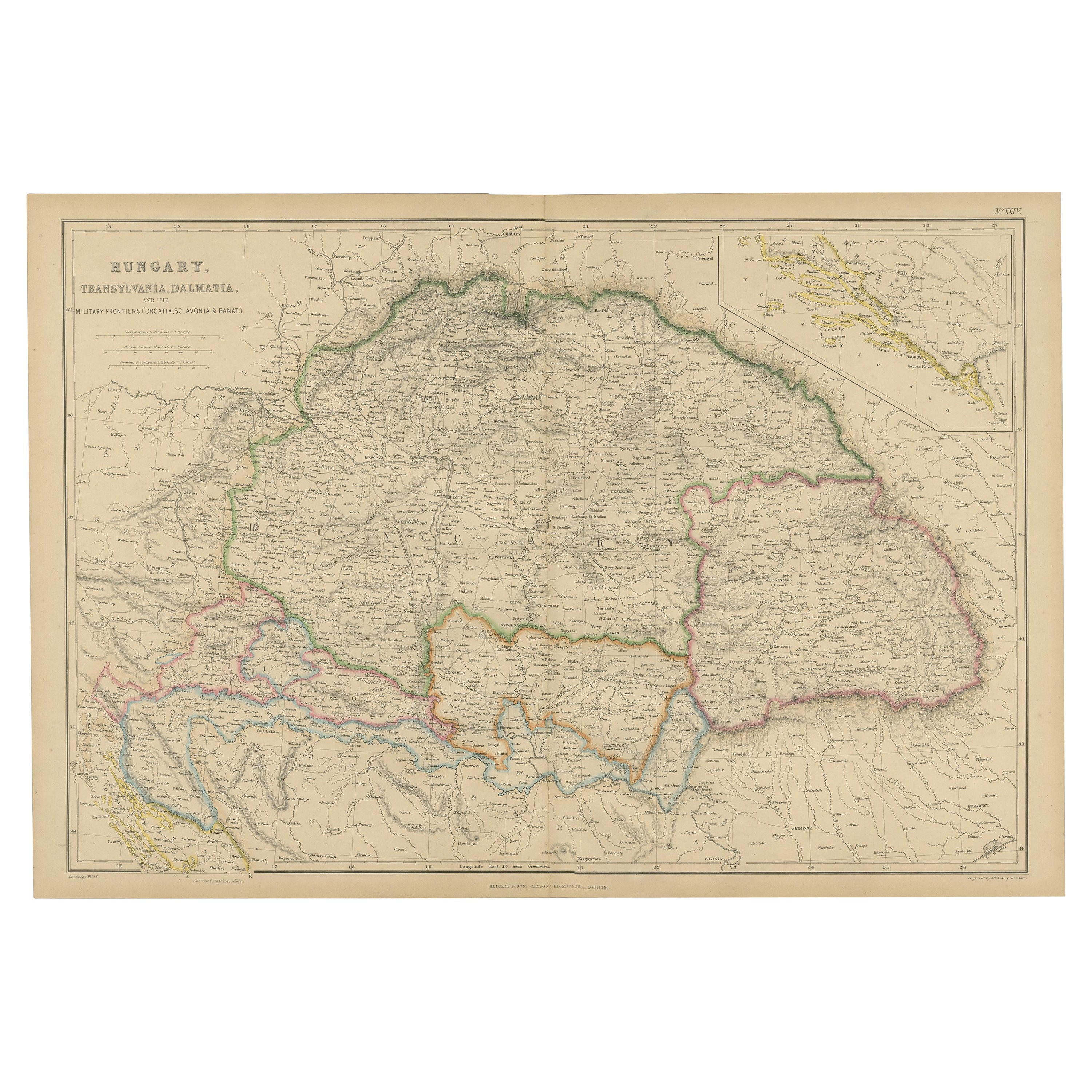
- Antique Map of Hungary, Transylvania and Dalmatia by W. G. Blackie, 1859Located in Langweer, NLAntique map titled 'Hungary, Transylvania, Dalmatia'. Original antique map of Hungary, Transylvania (Romania), Dalmatia (Croatia) and the Military Frontiers (Croatia, Slavonia & Bana...Category
Antique Mid-19th Century Maps
MaterialsPaper
- Antique Map of France by Mortier 'c.1710'Located in Langweer, NLAntique map titled 'Gallia vetus ex C. Iulii Caesaris (..)'. Original antique map of France. Published by P. Mortier, c.1710.Category
Antique Early 18th Century Maps
MaterialsPaper
- Antique Map of the Coast of France, 1710By Jacobus HarrewijnLocated in Langweer, NLAntique map titled 'Les Embouchures de la Somme et de Bresle'. Map of the coast of Northern France showing the estuaries of the Somme and the Bresle. This map is part of a serie of...Category
Antique Early 18th Century Maps
MaterialsPaper

- Old Engraved Map of Hungary with Decorative Vignettes, 1851Located in Langweer, NLAntique map titled Hungary. Includes decorative vignettes titled Hungarian Peasants, Pesth and the Fortress of Buda, on the Danube and Hungarian Nobles. Originates from 'The Illustrated Atlas, And Modern History Of The World Geographical, Political, Commercial & Statistical, Edited By R. Montgomery Martin'. Published; John Tallis London, New York, Edinburgh & Dublin. 1851. Drawn and Engraved by J. Rapkin. Artists and Engravers: John Tallis (1817-1876) was a British map publisher. Born in the Midlands, Tallis came to London in the 1840s. Tallis began his London career with a series of remarkable London street views. He began a partnership with a Frederick Tallis, possibly his brother, but their collaboration ended in 1849. For the Great Exhibition of 1851, Tallis published the Illustrated World Atlas, one of the last series of decorative world maps ever produced. The maps were engraved by John Rapkin, a skilled artisan. The maps were later reissued by the London Printing & Publishing Company, who left the Tallis imprint intact, thus ensuring his enduring fame. In 1858, he began publication of the popular Illustrated News of the World...Category
Antique 19th Century Maps
MaterialsPaper
- Antique Map of Southeast Asia by J. Ottens, 1710Located in Langweer, NLAntique map titled 'Le Royaume de Siam avec Les Royaumes Qui Luy sont Tributaries'. Influential map of Southeast Asia. Ottens incorporated information provided by the French Jesuits ...Category
Antique Early 18th Century Maps
MaterialsPaper


You May Also Like
- Original Antique Map of Hungary, Arrowsmith, 1820Located in St Annes, LancashireGreat map of Hungary Drawn under the direction of Arrowsmith. Copper-plate engraving. Published by Longman, Hurst, Rees, Orme and Brown, 1820 Unframed.Category
Antique 1820s English Maps
MaterialsPaper
- Original Antique Map of Spain and Portugal, Engraved By Barlow, 1806Located in St Annes, LancashireGreat map of Spain And Portugal Copper-plate engraving by Barlow Published by Brightly & Kinnersly, Bungay, Suffolk. 1806 Unframed.Category
Antique Early 1800s English Maps
MaterialsPaper
- Original Antique Map of Sweden, Engraved by Barlow, 1806Located in St Annes, LancashireGreat map of Sweden Copper-plate engraving by Barlow Published by Brightly & Kinnersly, Bungay, Suffolk. 1806 Unframed.Category
Antique Early 1800s English Maps
MaterialsPaper
- Original Antique Map of Switzerland, Engraved By Barlow, Dated 1807Located in St Annes, LancashireGreat map of Switzerland Copper-plate engraving by Barlow Published by Brightly & Kinnersly, Bungay, Suffolk. Dated 1807 Unframed.Category
Antique Early 1800s English Maps
MaterialsPaper
- Original Antique Map of The Netherlands, Engraved by Barlow, Dated 1807Located in St Annes, LancashireGreat map of Netherlands Copper-plate engraving by Barlow Published by Brightly & Kinnersly, Bungay, Suffolk. Dated 1807 Unframed.Category
Antique Early 1800s English Maps
MaterialsPaper
- Antique Map of Principality of MonacoBy Antonio Vallardi EditoreLocated in Alessandria, PiemonteST/619 - "Old Geographical Atlas of Italy - Topographic map of ex-Principality of Monaco" - ediz Vallardi - Milano - A somewhat special edition ---Category
Antique Late 19th Century Italian Other Prints
MaterialsPaper


Recently Viewed
View AllMore Ways To Browse
Antique Engrave
Date Engraved
Modern Hungary
Hungarian Designer
Furniture Romania
Romanian Antique Furniture
Antique Budapest
Traditional Romanian
Romanian Artist
Antique Furniture Budapest
C Moll
Hungary Map
Maps Hungary
Hungary Antique Map
Map Of Hungary
Romania Antique Map
Romania Map
Antique Maps Of United States