Items Similar to Original Antique Map of Hungary and Transylvania 'Modern Day Romania', C.1710


Want more images or videos?
Request additional images or videos from the seller
1 of 5
Original Antique Map of Hungary and Transylvania 'Modern Day Romania', C.1710
About the Item
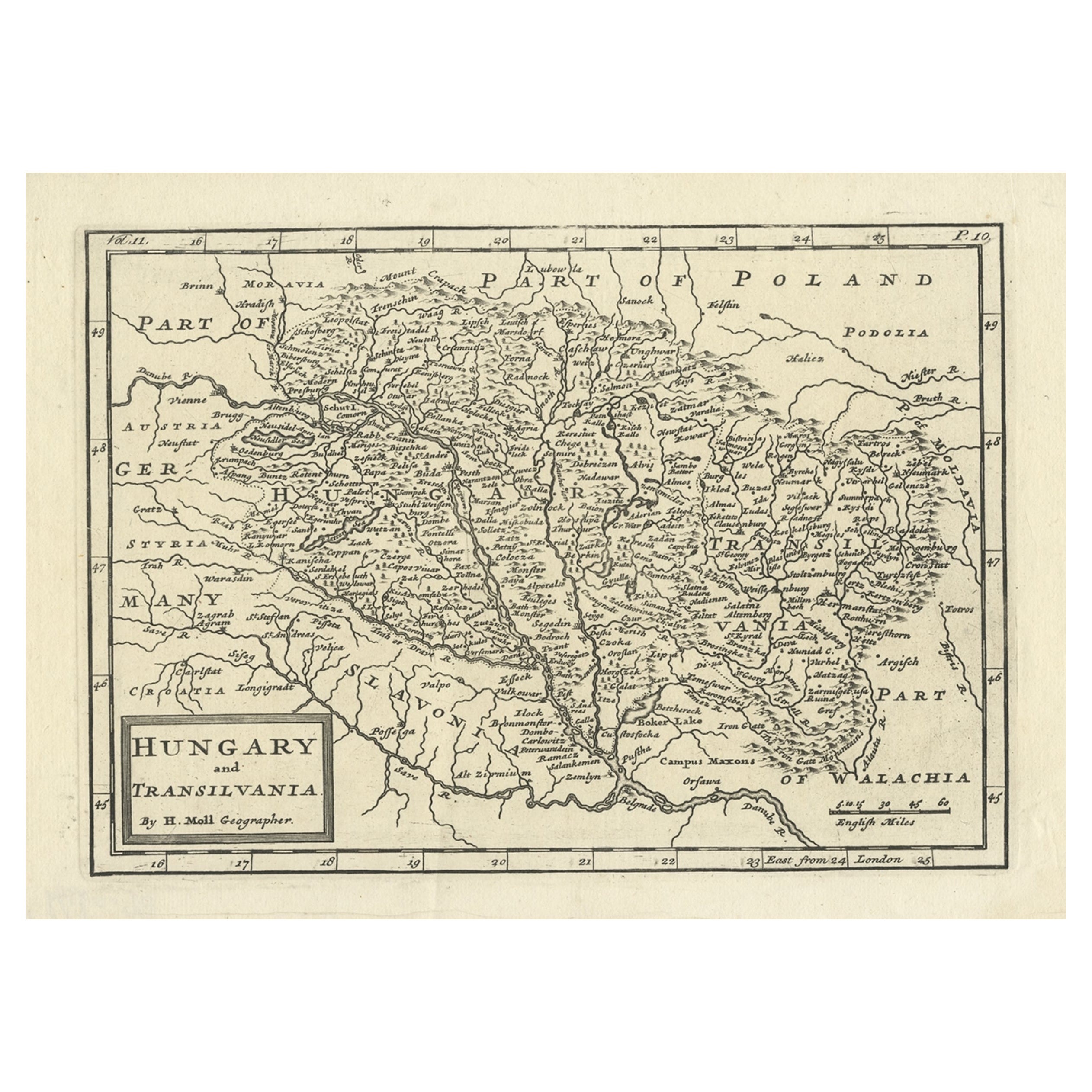
Antique map titled 'Hungary and Transilvania'.
Original antique map of Hungary and Transylvania (modern day Romania), centered on Budapest.
Artists and Engravers: Herman Moll (1654 - 1732), was a London cartographer, engraver and publisher.
- Dimensions:Height: 9.45 in (24 cm)Width: 14.38 in (36.5 cm)Depth: 0 in (0.02 mm)
- Materials and Techniques:
- Period:1710-1719
- Date of Manufacture:circa 1710
- Condition:Condition: Good, stain outside image. Minor defects, please study image carefully.
- Seller Location:Langweer, NL
- Reference Number:
About the Seller
5.0
Platinum Seller
These expertly vetted sellers are 1stDibs' most experienced sellers and are rated highest by our customers.
Established in 2009
1stDibs seller since 2017
1,932 sales on 1stDibs
Typical response time: <1 hour
- ShippingRetrieving quote...Ships From: Langweer, Netherlands
- Return PolicyA return for this item may be initiated within 14 days of delivery.
More From This SellerView All
- Antique Engraved Map of Hungary and Transylvania or Romania, c.1710Located in Langweer, NLAntique map titled 'Hungary and Transilvania'. Original antique map of Hungary and Transylvania (modern day Romania), centered on Budapest. Artists and ...Category
Antique 18th Century Maps
MaterialsPaper
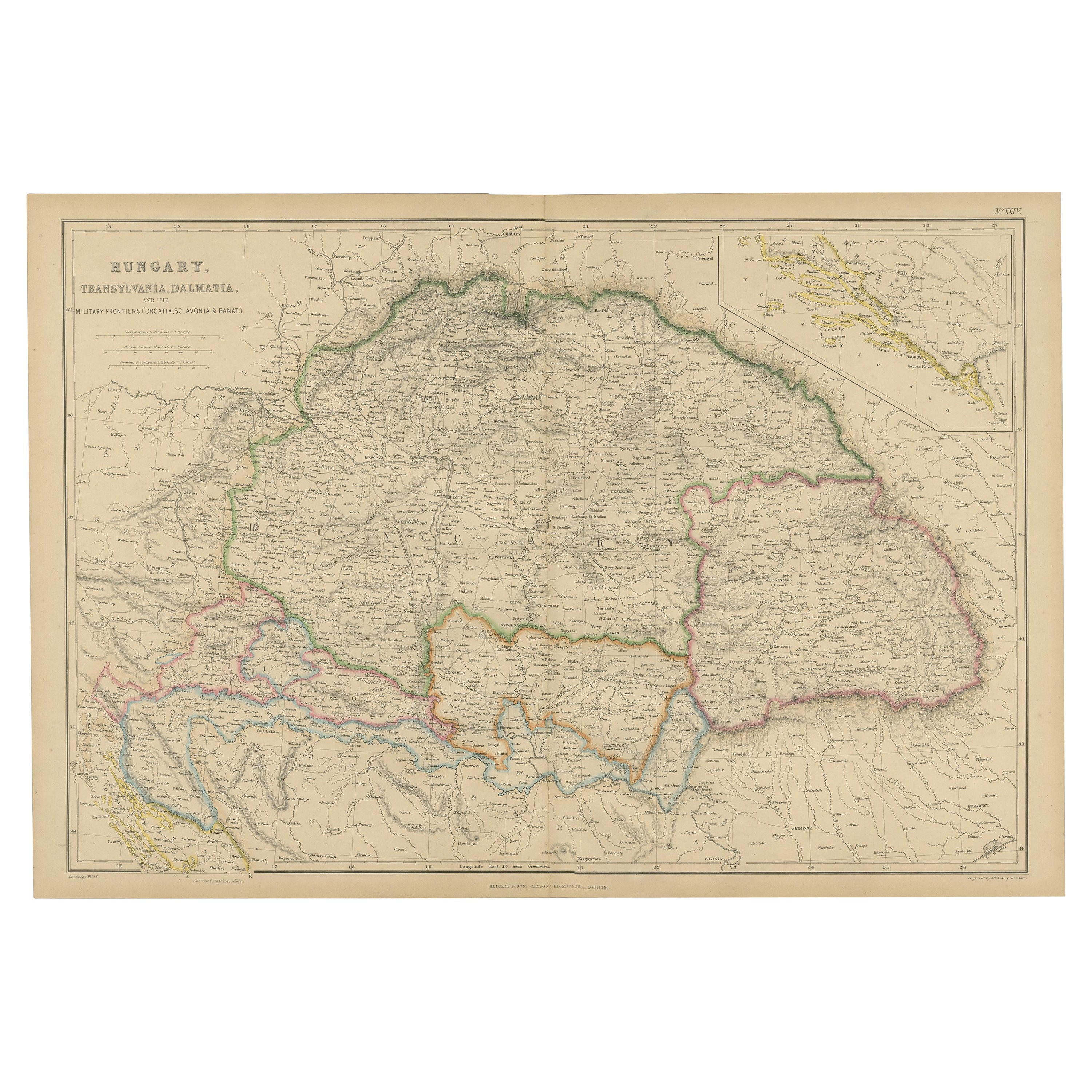
- Antique Map of Hungary, Transylvania and Dalmatia by W. G. Blackie, 1859Located in Langweer, NLAntique map titled 'Hungary, Transylvania, Dalmatia'. Original antique map of Hungary, Transylvania (Romania), Dalmatia (Croatia) and the Military Frontiers (Croatia, Slavonia & Bana...Category
Antique Mid-19th Century Maps
MaterialsPaper
- Antique Map of France by Mortier 'c.1710'Located in Langweer, NLAntique map titled 'Gallia vetus ex C. Iulii Caesaris (..)'. Original antique map of France. Published by P. Mortier, c.1710.Category
Antique Early 18th Century Maps
MaterialsPaper
- Antique Map of the Coast of France, 1710By Jacobus HarrewijnLocated in Langweer, NLAntique map titled 'Les Embouchures de la Somme et de Bresle'. Map of the coast of Northern France showing the estuaries of the Somme and the Bresle. This map is part of a serie of...Category
Antique Early 18th Century Maps
MaterialsPaper

- Antique Map of Southeast Asia by J. Ottens, 1710Located in Langweer, NLAntique map titled 'Le Royaume de Siam avec Les Royaumes Qui Luy sont Tributaries'. Influential map of Southeast Asia. Ottens incorporated information provided by the French Jesuits ...Category
Antique Early 18th Century Maps
MaterialsPaper
- Antique Map of Essex by Overton, circa 1710Located in Langweer, NLAntique map titled 'Essex, devided into Hundreds, with the most antient and fayre Towne Colchester (..)'. Map of Essex, England. Includes an inset town pl...Category
Antique Early 18th Century Maps
MaterialsPaper


You May Also Like
- Original Antique Map of Hungary, Arrowsmith, 1820Located in St Annes, LancashireGreat map of Hungary Drawn under the direction of Arrowsmith. Copper-plate engraving. Published by Longman, Hurst, Rees, Orme and Brown, 1820 Unframed.Category
Antique 1820s English Maps
MaterialsPaper
- Original Antique Map of Italy. C.1780Located in St Annes, LancashireGreat map of Italy Copper-plate engraving Published C.1780 Unframed.Category
Antique Early 1800s English Georgian Maps
MaterialsPaper

- Original Antique Map of Asia. C.1780Located in St Annes, LancashireGreat map of Asia Copper-plate engraving Published C.1780 Two small worm holes to right side of map Unframed.Category
Antique Early 1800s English Georgian Maps
MaterialsPaper

- Original Antique Map of India. C.1780Located in St Annes, LancashireGreat map of India Copper-plate engraving Published C.1780 Three small worm holes to right side of map and one bottom left corner Unframed.Category
Antique Early 1800s English Georgian Maps
MaterialsPaper

- Original Antique Map of Spain and Portugal, circa 1790Located in St Annes, LancashireSuper map of Spain and Portugal Copper plate engraving by A. Bell Published, circa 1790. Unframed.Category
Antique 1790s English Other Maps
MaterialsPaper
- Original Antique Map of Italy. Arrowsmith. 1820Located in St Annes, LancashireGreat map of Italy Drawn under the direction of Arrowsmith Copper-plate engraving Published by Longman, Hurst, Rees, Orme and Brown, 1820 Unframed.Category
Antique 1820s English Maps
MaterialsPaper


Recently Viewed
View AllMore Ways To Browse
Antique And Modern Furniture
Modern And Antique Furniture
Romanian Antique Furniture
Antique Budapest
Romanian Artist
Antique Furniture Budapest
C Moll
Hungary Map
Maps Hungary
Hungary Antique Map
Map Of Hungary
Romania Antique Map
Romania Map
Wood Carvings Of Ships
Classroom Furniture Used
Fine Antique Maps
17th Century World Map
Book Of Antique Maps