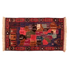
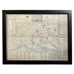
Vintage Beluch Tribal Rug depicting the Map of Afghanistan
Located in Milan, IT
A curious pictorial rug, woven by the Afghani Beluch people, illustrating a map of Afghanistan
Category
1990s Afghan Other The Vintage Map
Materials
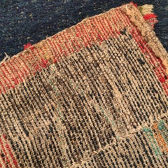
Wool
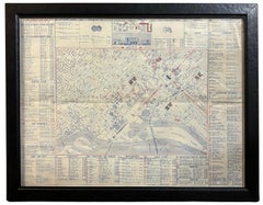
Vintage Beluch Tribal Rug depicting the Map of Afghanistan
Located in Milan, IT
A curious pictorial rug, woven by the Afghani Beluch people, illustrating a map of Afghanistan
Wool
$760Sale Price|35% Off
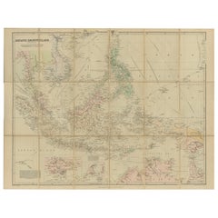
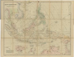
Antique Map of the Asiatic Archipelago by E. Stanford, circa 1910
Located in Langweer, NL
Antique folding map titled 'London Atlas Map of the Asiatic Archipelago'. Centered on the
Paper
$540Sale Price|20% Off
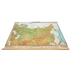
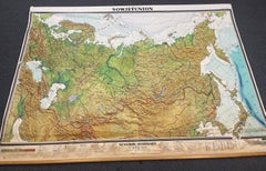
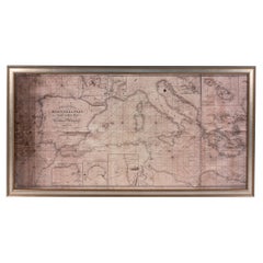
Massive Vintage Wall Map of the Soviet Union 'Sowjetunion' by Karl Wenschow
By Denoyer-Geppert
Located in San Diego, CA
A massive vintage wall map of the Soviet Union (Sowjetunion) published by Karl Wenschow in Munich
Paper, Wood
$380Sale Price|20% Off
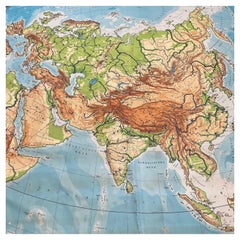
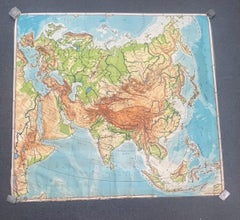
Huge Europe and Asia Vintage Wall Map
Located in San Diego, CA
A huge Europe and Asia vintage wall map, circa 1950s. The map is in fair vintage condition and
Paper
1943 "USO Map Guide to Washington"
Located in Colorado Springs, CO
This is a WWII map of Washington, DC, issued as a guide for service men and women visiting or
Paper

$945Sale Price|30% Off
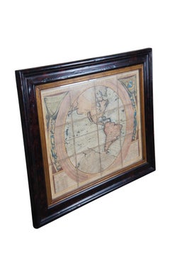
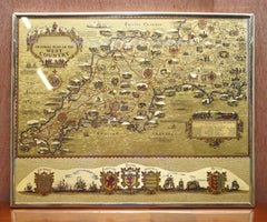
Vincenzo Coronelli's Colored Map of the New World Western Hemisphere Framed 47"
By Vincenzo Coronelli
Located in Dayton, OH
A Framed Reproduction of Coronelli's Map of the New World, Attributed to Trevor James Company. The
Paper
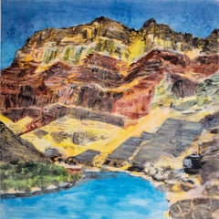
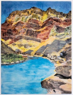
On the Map: Large scale color monotype, Western mountain landscape with blue sky
By Michele Zalopany
Located in New York, NY
. The imagery of On the Map is taken from an old picture book. Born in 1955 in Detroit Michigan
Monotype
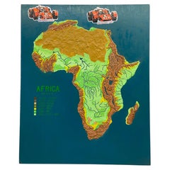
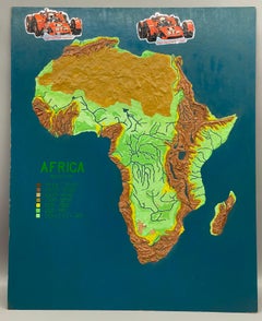
Physical Relief Map of Africa, 1970s Educational Decor
Located in New Windsor, NY
Physical relief map of Africa. Jerry, our artist, has painstakingly reproduced the desserts, rivers
Masonite, Paint
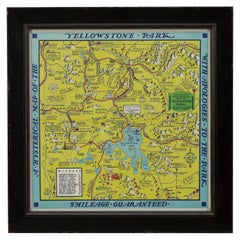
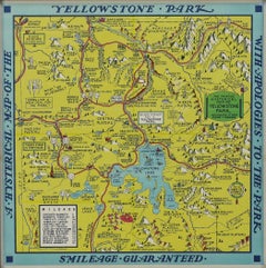
1948 "A Hysterical Map of Yellowstone National Park" by Jolly Lindgren, 2nd Ed.
Located in Colorado Springs, CO
Presented is a second edition printing of Jolly Lindgren’s “Hysterical Map of Yellowstone National
Paper
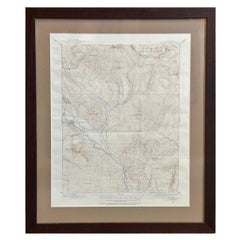
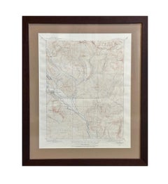
Vintage "Colorado, Crested Butte Sheet" USGS Topographical Map, 20th Century
By United States Geological Survey
Located in Colorado Springs, CO
Presented is a vintage "Colorado, Crested Butte Sheet" topographical map, first published by the
Paper

$70Sale Price|20% Off
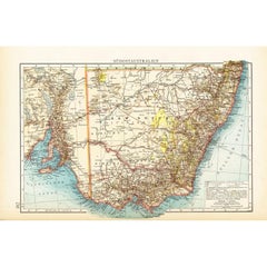
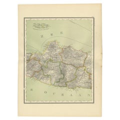
German Antique Map of Southeastern Australia, 1904
Located in Langweer, NL
This large antique map is taken from; 'Andrees Allgemeiner Handatlas in 126 Haupt-Und 139
Paper

$102Sale Price|20% Off
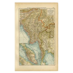
Antique Map of Burma and the Malayan Peninsula by Andree, 1904
Located in Langweer, NL
Antique map titled 'Burma und Malayische Halbinsel'. Map of Burma / Myanmar and the Malayan
Paper


Vintage Reproduction 17th Century Map of Europe, American, Cartography, Blaeuw
Located in Hele, Devon, GB
This is a vintage reproduction map of Europe. An American, paper stock cartography print in frame
Glass, Wood, Paper

$126Sale Price|20% Off
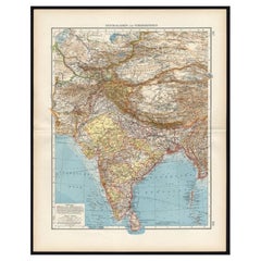
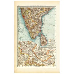
Antique Map of Central Asia and India, 1904
Located in Langweer, NL
Antique map titled 'Zentralasien und Vorderindien'. Map of Central Asia and India. This large
Paper
$84Sale Price|20% Off
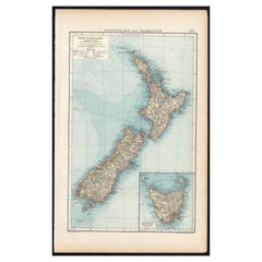
Antique Map of New Zealand and Tasmania, 1904
Located in Langweer, NL
This large antique map is taken from; 'Andrees Allgemeiner Handatlas in 126 Haupt-Und 139
Paper

$68Sale Price|20% Off
Antique Map of Southern India by Andree, 1904
Located in Langweer, NL
"Antique map titled 'Vorderindien, sudlicher Teil'. Map of India, southern part. This map
Paper
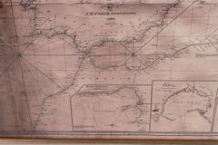
Large Framed Map of the Mediterranean
Located in Queens, NY
Large map/chart chart of The Mediterranean and the Grecian Archipelago showing Italy, Sardinia
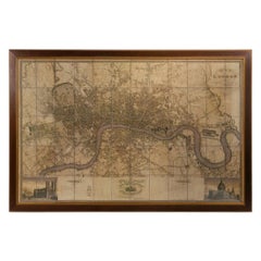
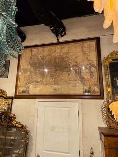
Large Scale Map of the London Metropolis
Located in Dallas, TX
The product is a large scale map of the London Metropolis, specifically focusing on the city in
Paper
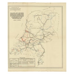
Vintage Road Map of the Netherlands '1928'
Located in Langweer, NL
Vintage map titled 'Volgens het vijfjarig Werkplan te verbeteren Rijkswegen en nieuw aan te leggen
Paper
$841Sale Price|20% Off
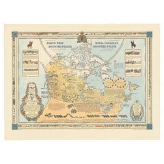
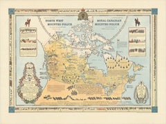
The History of the Royal Canadian Mounted Police, Published in 1966
Located in Langweer, NL
This rare pictorial map by Peter R. Furse celebrates the history of the Royal Canadian Mounted
Paper
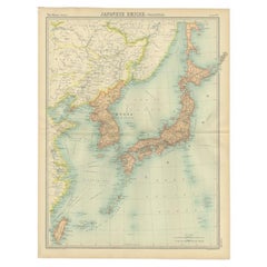
Antique Political Map of the Japanese Empire, 1922
Located in Langweer, NL
Antique map of Japan titled 'Japanese Empire - Political Map'. Old map of Japan depicting Japan
Paper
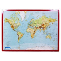
George Philip's Large Relief Map of the World 150x110cm
By George Philip & Son
Located in Linkebeek, BE
George Philip's Large Relief Map of the World 150x110cm PHILIP, George Relief Map of the World
Plastic, Wood
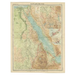

Antique Map of the Region of the Nile River by Bartholomew, 1922
Located in Langweer, NL
Antique map of Africa titled 'Egypt and the Nile'. Old map of Africa depicting Egypt, the Nile
Paper
$131Sale Price|20% Off
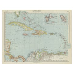
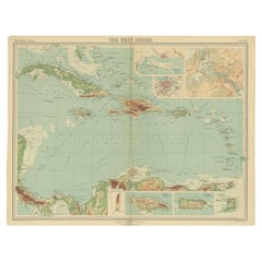
Vintage Map of the Greater Antilles and Lesser Antilles
Located in Langweer, NL
Vintage map titled 'Antilles'. Original map of the Antilles. Shows the Cayman Islands, Cuba
Paper


Antique Map of the Region of Banjarmasin, Indonesia 1900
Located in Langweer, NL
Antique Map of the Region of Banyuasin, Sumatra. Also depicting Bangka/Banka island. This map
Paper
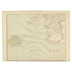

Antique Map of the Java Sea by Dornseiffen, 1900
Located in Langweer, NL
Antique map of the Java Sea. Also depicts Bilitung, the Karimata Islands and Sukadana, Borneo. This
Paper


Antique Map of the Nias Archipelago, Sumatra, Indonsia, 1900
Located in Langweer, NL
Antique map of Nias Island and surrounding islands including the Banyak islands, Pini island and
Paper
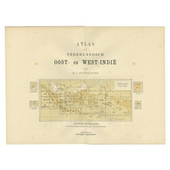

Antique Map of the East Indies by Dornseiffen, 1900
Located in Langweer, NL
of the various maps included in this atlas. Included are the Dutch East Indies and the Kingdom of the
Paper
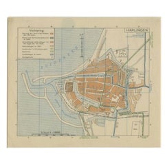

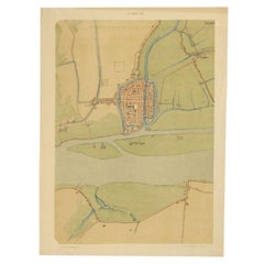
Vintage Map of the Frisian City of Harlingen, 1930
Located in Langweer, NL
Vintage map titled 'Harlingen'. Original map of the city of Harlingen, Friesland, the Netherlands
Paper

$79Sale Price|20% Off
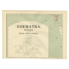
Antique Map of the Batu Islands by Dornseiffen, 1900
Located in Langweer, NL
Antique map of the Batu Islands with the large title 'Soematra, Bangka en de Riouw-Lingga Archipel
Paper
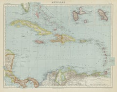
Antique Map of the West Indies in Full Color, 1922
Located in Langweer, NL
Antique map titled 'The West Indies.' A map of the West Indies, the Carribean region. This includes
Paper


Antique Map of the East Coast of Sumatra , Indonesia, 1900
Located in Langweer, NL
Antique map of the East Coast of Sumatra. Also depicting the Strait of Malacca. This map originates
Paper

Antique Map of the Region of Bengkulu in Indonesia, 1900
Located in Langweer, NL
Antique map of the region of Benkulu, Sumatra. Also depicting Enggano Island. This map originates
Paper

Antique Map of the Dutch Provinces Groningen and Friesland, 1902
Located in Langweer, NL
Antique map titled 'Groningen en Friesland'. Lithographed map of the provinces of Groningen and
Paper
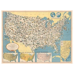
Old Decorative Pictorial Map of the United States, circa 1953
Located in Langweer, NL
Antique map titled 'A Pictorial Map of the United States of America Showing Principal Regional
Paper
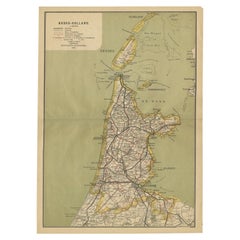

Antique Map of Noord-Holland, Province of The Netherlands, 1902
Located in Langweer, NL
Antique map titled 'Noord-Holland'. Lithographed map of the province of Noord-Holland, the
Paper

$60Sale Price|20% Off
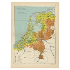
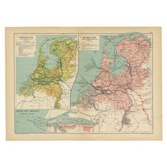
Antique Elevation Map of the Netherlands by Beekman & Schuiling, 1927
Located in Langweer, NL
Antique map titled 'Nederland Hoogtekaart'. This map originates from 'Schoolatlas der Geheele Aarde
Paper
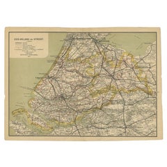

Antique Map of Zuid-Holland and Utrecht in The Netherlands, 1902
Located in Langweer, NL
Antique map titled 'Zuid-Holland en Utrecht'. Lithographed map of the provinces of Zuid-Holland and
Paper

$130Sale Price|20% Off
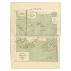
Antique Map of the West Indies and Ambon in Indonesia, 1900
Located in Langweer, NL
Two maps on one sheet titled 'De West-Indische Eilanden (Nederlandsch Gedeelte)' and 'Ambon, Leasi
Paper
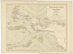
Antique Map of the Moluccas and Irian Jaya (Papua), Indonesia, 1900
Located in Langweer, NL
Antique map titled 'De Moluksche Eilanden en Nieuw Guinea'. Old map of the Moluccas or Maluku
Paper
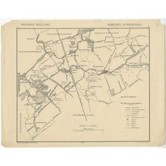
Antique Map of the Region of Utingeradeel by Meijer & Schaafsma, 1906
Located in Langweer, NL
Antique map titled 'Gemeente Friesland. Gemeente Utingeradeel'. This map illustrates part of
Paper

Antique Map of Central Java Depicting The Karimun Islands, Indonesia, 1900
Located in Langweer, NL
Antique map of Central Java, also depicting the Karimun Islands. This map originates from 'Atlas
Paper


$79Sale Price|20% Off
Old Map of the Dutch City of Megen in Holland, 1916
Located in Langweer, NL
Antique map Megen titled 'Megen'. Antique map depicting the city of Megen, Noord-Brabant, The
Paper
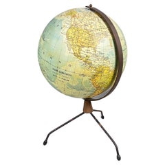
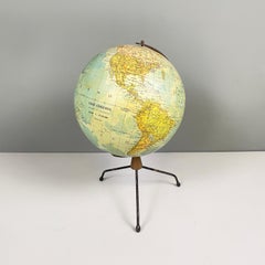
Italian modern Table globe map of the world in metal, 1960s
Located in MIlano, IT
Italian modern Table globe map of the world in metal, 1960s Table map of the world with metal
Metal
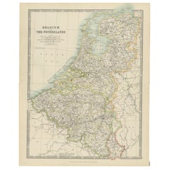

Antique Map of Belgium and the Netherlands by Johnston 'c.1920'
Located in Langweer, NL
Antique map titled 'Belgium and the Netherlands'. Original antique map of Belgium and the
Paper

$60Sale Price|20% Off
Antique Map of the Netherlands and IJmuiden by Beekman & Schuiling, 1927
Located in Langweer, NL
Two maps on one sheet titled 'Nederland Landbouwkaart' and 'Nederland Groote Verkeerswegen'. With
Paper

$79Sale Price|20% Off
Old Map of The Frisian City of Workum in Holland, 1916
Located in Langweer, NL
Antique map Workum titled 'Workum'. Antique map depicting the Frisian city of Workum, the
Paper
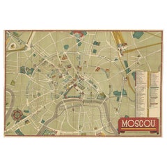
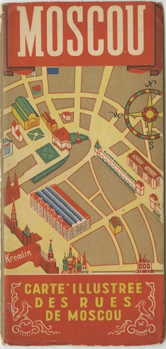
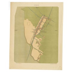
Vintage Folding Map of the Streets of Moscow, Russia, circa 1950
Located in Langweer, NL
Antique map titled 'Carte Illustree des Rues de Moscou'. Vintage folding map of the streets of
Paper

$1,123Sale Price|20% Off
Large Topographical and Geological Map of the Teshio Oil Field, '1936'
Located in Langweer, NL
Topographical and geological map of the Teshio oil field. Shows location of oil well, oil sand
Linen, Paper
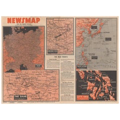
Antique Map of the War Situation in Europe and Asia, 1944
Located in Langweer, NL
Antique map titled 'Newsmap for the Armed Forces'. This "newsmap" was issued on Monday, December 18
Paper


$116Sale Price|44% Off
Antique Map of the Region of Tokyo and Nagasaki in Japan, 1922
Located in Langweer, NL
Antique map of Japan titled 'Japan - Environs of Tokio & Nagasaki'. Old map of Japan, includes
Paper

$2,193Sale Price|25% Off
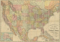
Antique Railroad Map of the United States by Rand, McNally & Co, 1900
Located in Langweer, NL
Antique map titled 'Rand, McNally & Co's New Official Railroad map of the United States with
Linen, Paper

$70Sale Price|20% Off
Antique Map of The Dutch City of Gorinchem by Smulders, Lithograph, 1916
Located in Langweer, NL
Antique map Gorinchem titled 'Gorkum'. Antique map depicting the city of Gorinchem, The Netherlands
Paper

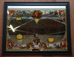
Vintage World Map Mirror Based on the Original by Johnson 1882 Military Campaign
Located in West Sussex, Pulborough
We are delighted to offer for sale this lovely Antique style pictorial plan map of the globe based
Mirror

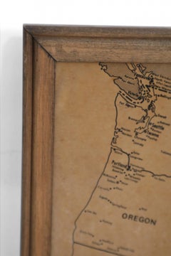
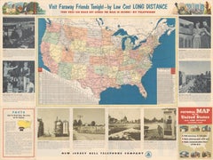
Vintage Framed United States Map
Located in Queens, NY
Vintage aged paper map of the United States mounted on particle board and framed in a simple wooden
Wood, Paper

$2,100Sale Price|30% Off
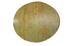
20th Century Large Vintage Oval Wall Map of the World Globe Conference Table 13'
Located in Dayton, OH
Monumental oval classroom map of the world / wall globe from the second half of the 20th century
Metal

Gold Leaf Foil Pictorial Plan Map of the West Country of England Antique Style
Located in West Sussex, Pulborough
We are delighted to offer for sale this lovely Antique style pictorial plan map of the West Country
Gold Leaf