Items Similar to Antique Map of the Asiatic Archipelago by E. Stanford, circa 1910


Want more images or videos?
Request additional images or videos from the seller
1 of 5
Antique Map of the Asiatic Archipelago by E. Stanford, circa 1910
About the Item
Antique folding map titled 'London Atlas Map of the Asiatic Archipelago'. Centered on the Philippines and Borneo, the map shows a number of different seasonal passages through the region to Hong Kong and Macao. With inset maps of Singapore and Labuan Island.
- Dimensions:Height: 20.48 in (52 cm)Width: 22.45 in (57 cm)Depth: 0.4 in (1 cm)
- Materials and Techniques:
- Period:
- Date of Manufacture:circa 1910
- Condition:Fold. cold. map in 18 sections, on linen. 57 x 52 cm. In ocl. bind. (Spine a bit worn). Minor wear and small defects, please study images carefully.
- Seller Location:Langweer, NL
- Reference Number:Seller: BG-12742-31stDibs: LU3054321596572
About the Seller
5.0
Platinum Seller
These expertly vetted sellers are 1stDibs' most experienced sellers and are rated highest by our customers.
Established in 2009
1stDibs seller since 2017
1,916 sales on 1stDibs
Typical response time: <1 hour
- ShippingRetrieving quote...Ships From: Langweer, Netherlands
- Return PolicyA return for this item may be initiated within 14 days of delivery.
Auctions on 1stDibs
Our timed auctions are an opportunity to bid on extraordinary design. We do not charge a Buyer's Premium and shipping is facilitated by 1stDibs and/or the seller. Plus, all auction purchases are covered by our comprehensive Buyer Protection. Learn More
More From This SellerView All
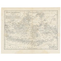
- Antique Map of the Malay Archipelago by Walker, 1911Located in Langweer, NLAntique map titled 'Malay Archipelago'. Old map of the Malay Archipelago including Borneo, Celebes, New Guinea, Java, Timor and others. This map ...Category
Early 20th Century Maps
MaterialsPaper
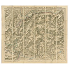
- Antique Map of the North-West Frontier by Stanford, 1895By E. StanfordLocated in Langweer, NLAntique map titled 'Stanford's Sketch Map of the North West Frontier of India from Peshawar to the Pamirs'. Linen backed folding map of the North-West Frontier of India from Peshawar...Category
Antique Late 19th Century Maps
MaterialsLinen, Paper
- Antique Map of Part of the Korean Archipelago, 1798Located in Langweer, NLAntique map titled 'Plan of Part of the Islands or Archipellago of Corea'. This map depicts part of the Korean Archipelago and originates from Charts and Plates to La Pérouse...Category
Antique Late 18th Century Maps
MaterialsPaper
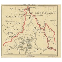
- Antique Map of Northern Natal by Stanford, 1900Located in Langweer, NLAntique map titled 'Northern Natal'. Lithograph of Northern Natal. The Colony of Natal was a British colony in south-eastern Africa. It was proclaimed a British colony on 4 May 1843 ...Category
Early 20th Century Maps
MaterialsPaper
- Antique Map of the Nias Archipelago, Sumatra, Indonsia, 1900Located in Langweer, NLAntique map of Nias Island and surrounding islands including the Banyak islands, Pini island and Simeulue Island. This map originates from 'Atlas van Nederlandsch Oost- en West-Indië...Category
20th Century Maps
MaterialsPaper
- Antique Map of the Indonesian and Philippine Archipelagos by R. de VaugondyLocated in Langweer, NLStriking and highly detailed map of the region from Sumatra and Malaca and Southern China to the Philipines, New Guinea and Northern Australia, centered on Borneo. Includes a large i...Category
Antique Mid-18th Century Maps
MaterialsPaper


You May Also Like
- Map of the Republic of GenoaLocated in New York, NYFramed antique hand-coloured map of the Republic of Genoa including the duchies of Mantua, Modena, and Parma. Europe, late 18th century. Dimension: 25...Category
Antique Late 18th Century European Maps
- Antique Map of Italy by Andriveau-Goujon, 1843By Andriveau-GoujonLocated in New York, NYAntique Map of Italy by Andriveau-Goujon, 1843. Map of Italy in two parts by Andriveau-Goujon for the Library of Prince Carini at Palazzo Carini i...Category
Antique 1840s French Maps
MaterialsLinen, Paper
- Antique Map of Principality of MonacoBy Antonio Vallardi EditoreLocated in Alessandria, PiemonteST/619 - "Old Geographical Atlas of Italy - Topographic map of ex-Principality of Monaco" - ediz Vallardi - Milano - A somewhat special edition ---Category
Antique Late 19th Century Italian Other Prints
MaterialsPaper
- Antique 18th Century Map of the Province of Pensilvania 'Pennsylvania State'Located in Philadelphia, PAA fine antique of the colony of Pennsylvania. Noted at the top of the sheet as a 'Map of the province of Pensilvania'. This undated and anonymous map is thought to be from the Gentleman's Magazine, London, circa 1775, although the general appearance could date it to the 1760's. The southern boundary reflects the Mason-Dixon survey (1768), the western boundary is placed just west of Pittsburgh, and the northern boundary is not marked. The map has a number of reference points that likely refer to companion text and appear to be connected to boundaries. The western and southern boundaries are marked Q, R, S, for example. A diagonal line runs from the Susquehanna R to the Lake Erie P. A broken line marked by many letters A, B, N, O, etc., appears in the east. There are no latitude or longitude markings, blank verso. Framed in a shaped contemporary gilt wooden frame and matted under a cream colored matte. Bearing an old Graham Arader Gallery...Category
Antique 18th Century British American Colonial Maps
MaterialsPaper
- Map "Estuary- Mouth of the Thames"Located in Alessandria, PiemonteST/426 - Antique French Map of the estuary of the Thames, map dated 1769 - "Mape of the entrance of the Thames. Designed by filing of Navy cards fo...Category
Antique Mid-18th Century French Other Prints
MaterialsPaper
- Large Antique 1859 Map of North AmericaLocated in Sag Harbor, NYThis Map was made by Augustus Mitchell in 1859 It is in amazing condition for being 163 years old. This price is for the rolled up easy to ship version of this piece. I will be Frami...Category
Antique Mid-19th Century American Maps
MaterialsCanvas, Paper


Recently Viewed
View AllMore Ways To Browse
Antique E
The Vintage Map
Stanford Furniture
Stanford Used Furniture
Hong Kong Map
Vintage Folded Map
Antique Filipino
Singapore Vintage Furniture
Map Of Singapore
Singapore Map
Filipino Map
Philippines Map
Vintage Map Of Singapore
Antique Maps Philippines
Stanford Antiques
Antique Map Singapore
Used Furniture Edinburgh
Maps Of Europe