Collectibles and Curiosities on Sale

to
3,837
1,432
5,222
75
55
503
200
171
128
93
62
48
45
35
31
26
14
12
8
8
8
4
4
1,760
1,498
1,964
130
452
789
357
58
36
71
119
63
208
135
128
76
45
2,950
1,399
773
341
267
1,498
486
401
291
265
5,352
5,327
5,348
54
53
22
21
18
Sale Items
Antique Religious Print "No. 34" Jesus Carrying the Cross, circa 1840
Located in Langweer, NL
Antique print titled ‘Histoire Sainte, Nouveau Testament, Jésus portant sa Croix, console les filles de Jérusalem.’ This plate shows a scene from the New Testament; Jesus carrying the Cross...
Category

Antique Mid-19th Century Prints

Materials

Paper

Old Decorative Map of Austria, Centered on the Danube River and Vienna, Ca.1720
Located in Langweer, NL
Antique map titled 'Archiducatus Austriae inferioris (..).' Decorative map of Austria, centered on the course of the Danube River and Vienna. Shows the region from Enss and Steyr to ...
Category

Antique 1720s Maps

Materials

Paper

French Late 19th Century Neo Gothic Gilded Metal Saint Statue
Located in Buisson, FR
Wonderful gilded metal saint statue with beautiful expression, France, circa 1880-1900. Weathered. Measurements include the wooden base.
Category

Antique Late 19th Century French Gothic Revival Religious Items

Materials

Metal

Mid-20th Century Israeli Hanukkah Lamp Menorah by Dayagi
Located in New York, NY
Hanukkah lamp menorah made in Israel, circa 1950s. Signed on the bottom Dayagi. Green patina overlay in the front with a bold Star of David. A detailed scene of the spices on the way...
Category

Mid-20th Century Israeli Religious Items

Materials

Brass

Map of Liverpool and Birkenhead by Bartholomew, circa 1880, with Key Buildings
Located in Langweer, NL
Map of Liverpool and Birkenhead by J. Bartholomew, circa 1880, with key buildings Detailed city plan titled 'Liverpool and Birkenhead with the surrounding districts', drawn by J. Ba...
Category

Antique 1880s Maps

Materials

Paper

Map of Amersfoort and Surroundings by Covens & Mortier, published in 1747
Located in Langweer, NL
Map of Amersfoort and Surroundings by Covens & Mortier, published in 1747 Hand-coloured copper engraving titled *Carte Particulière des Environs de Amersfoort*, created by Jean Cove...
Category

Antique 1740s Maps

Materials

Paper

Antique Print of Napoleon Wars of the Battle of 4 November 1812, 1845
Located in Langweer, NL
Antique print titled 'Der 4 November'. Original antique print of the battle of 4 November 1812, part of Napoleon's retreat from Moscow. This print originates from 'Der Feldzug von 18...
Category

Antique 19th Century Prints

Materials

Paper

Zebra Stone and Silver Bird Model
Located in London, GB
Zebra stone and silver bird model Height 8cm, width 9cm, depth 7cm Continental, 20th Century Expertly carved from zebra stone, the bird, most likely a wren, is sitting atop a fossi...
Category

20th Century European Other Models and Miniatures

Materials

Stone, Silver, Other

Antique Japanese Buddhism Book Edo Period, circa 1930
Located in Barcelona, ES
Antique Japanese Buddhism book Edo period, circa 1867 Woodblack print book Book dimensions: 226 mm x 159 mm There are damages because it is antique item as we show on the phot...
Category

Vintage 1930s Japanese Edo Books

Materials

Paper

Old Map of Gloucestershire by Samuel Lewis 1844 – Gloucester, Cheltenham, Bristo
Located in Langweer, NL
Title: Old Map of Gloucestershire by Samuel Lewis 1844 – Gloucester Cheltenham Bristol Cirencester Tewkesbury Description: This antique 1844 map of Gloucestershire was engraved for Samuel Lewis’ Topographical Dictionary of England. It includes major towns such as Gloucester, Cheltenham, Bristol, Cirencester, and Tewkesbury. Roads, rivers, and topographical details are finely engraved, with hand-colored borders marking the county boundaries. The map also shows neighboring counties including Herefordshire, Somerset, Wiltshire, and Oxfordshire. A decorative compass rose completes the elegant composition. Condition: The map is in good condition with slight age toning and wide clean margins. The engraved lines remain sharp and the original hand coloring is well preserved. Folding line as issued. No tears or stains are visible. Framing suggestions: Use an acid-free mat in ivory or light beige to complement the map’s aged tone. A dark wood, black, or antique gold frame will enhance the historic style. UV-protective glass is recommended for long-term preservation. Ideal for display in a home library, study, or office with a classic interior. Keywords: Gloucestershire map 1844 Samuel Lewis antique...
Category

Antique 1840s Maps

Materials

Paper

Old Map of Herefordshire 1844 – Hereford Leominster Ross-on-Wye Kington Bromyard
Located in Langweer, NL
Title: Old Map of Herefordshire by Samuel Lewis 1844 – Hereford Leominster Ross-on-Wye Kington Bromyard Description: This 1844 map of Herefordshire was drawn and engraved for Samuel Lewis’ Topographical Dictionary of England. It features major towns including Hereford, Leominster, Ross-on-Wye, Kington, and Bromyard. The map shows roads, rivers, topographical features, and surrounding counties such as Shropshire, Gloucestershire, and Monmouthshire. Hand-colored borders outline the county and a decorative compass rose enhances its historical charm. Condition: The map is in good antique condition with light even toning and wide margins. The engraving is sharp and the hand coloring remains bright. There are no tears or significant blemishes. Framing suggestions: Use an ivory or soft beige acid-free mat to complement the aged paper. A dark wood, antique gold, or soft black frame will bring out the map's classic style. UV-protective glass is recommended to preserve color and detail. A fine choice for traditional interiors, libraries, or heritage-themed décor. Keywords: Herefordshire map 1844 Samuel Lewis antique...
Category

Antique 1840s Maps

Materials

Paper

Old Map of Radnorshire 1844 – Presteigne Rhayader Knighton Llandrindod Wells
Located in Langweer, NL
Old Map of Radnorshire by Samuel Lewis 1844 – Presteigne Rhayader Knighton Llandrindod Wells Description: This original 1844 map of Radnorshire was engraved for Samuel Lewis’ Topographical Dictionary of Wales. It features key locations such as Presteigne, Rhayader, Knighton, Llandrindod Wells, and New Radnor. Hand-colored borders outline the county’s administrative divisions, and the map includes topographical shading, roads, rivers, and a decorative compass rose. A union reference key is clearly listed in the lower left. Condition: The map is in good condition with light toning and wide margins. The engraved lines remain crisp and the hand coloring is clear and unfaded. No tears or stains are present, with only minor age-related marks on the edges. Framing suggestions: Pair with an acid-free mat in cream or soft beige to match the aged tone of the paper. A dark wood or antique gold frame will enhance the historical feel. UV-protective glass is recommended. This piece is ideal for framing in a study, office, or heritage-themed space. Keywords: Radnorshire map 1844 Samuel Lewis antique...
Category

Antique 1840s Maps

Materials

Paper

Old Map of Montgomeryshire by 1844 – Welshpool Llanidloes Newtown Machynlleth
Located in Langweer, NL
Title: Old Map of Montgomeryshire by Samuel Lewis 1844 – Welshpool Llanidloes Newtown Machynlleth Description: This 1844 map of Montgomeryshire was engraved for Samuel Lewis’ Topographical Dictionary of Wales. It highlights principal towns such as Welshpool, Llanidloes, Newtown, and Machynlleth, with rivers, roads, and hill shading showing the region's terrain. The hand-colored borders mark the administrative divisions, and a decorative compass rose and union reference chart are included. Condition: The map is in good condition with light age toning and wide clean margins. The engraving is clear and the original hand coloring remains vibrant. No tears or major imperfections are present. Framing suggestions: An acid-free mat in ivory or soft beige will complement the aged paper tone. A dark wood, black, or antique gold frame will suit the historic style. UV-protective glass is recommended to preserve the colors. A beautiful display piece for those with ties to mid-Wales or an interest in antique cartography. Keywords: Montgomeryshire map 1844 Samuel Lewis antique...
Category

Antique 1840s Maps

Materials

Paper

Old Map of Cardiganshire by Lewis 1844 – Aberystwyth Cardigan Tregaron Lampeter
Located in Langweer, NL
Old Map of Cardiganshire by Samuel Lewis 1844 – Aberystwyth Cardigan Tregaron Lampeter This antique 1844 map of Cardiganshire was drawn and engraved ...
Category

Antique 1840s Maps

Materials

Paper

Map of Carmarthenshire 1844 – Carmarthen Llandeilo Llanelli Laugharne Llandovery
Located in Langweer, NL
Title: Old Map of Carmarthenshire by Samuel Lewis 1844 – Carmarthen Llandeilo Llanelli Laugharne Llandovery Description: This detailed 1844 map of Carmarthenshire was drawn and engraved for Samuel Lewis’ Topographical Dictionary of Wales. It highlights major towns such as Carmarthen, Llandeilo, Llanelli, Laugharne, and Llandovery. The county's roads, rivers, and hilly terrain are finely engraved and shaded, while original hand coloring outlines the administrative divisions. The map includes a compass rose and a reference to the seven unions within the county. Condition: The map is in very good antique condition with minimal age toning and wide clean margins. The engraving is crisp and the hand coloring remains bright and accurate. There are no tears or major defects. Framing suggestions: A cream or soft beige acid-free mat will complement the aged paper and hand coloring. Frame in dark wood, antique gold, or a muted black to highlight the historical character. Use UV-protective glass to preserve the colors. Suitable for traditional interiors, libraries, or as a heritage gift. Keywords: Carmarthenshire map 1844 Samuel Lewis antique...
Category

Antique 1840s Maps

Materials

Paper

Old Map of Merionethshire by Lewis, 1844: Barmouth, Bala, Harlech, Dolgelley
Located in Langweer, NL
Old Map of Merionethshire by Samuel Lewis 1844 – Barmouth Bala Harlech Dolgelley Description: This finely engraved hand-colored map of Merionethshire was published in 1844 for Samu...
Category

Antique 1840s Maps

Materials

Paper

Old Map of Glamorganshire by Lewis 1844 – Swansea Cardiff Merthyr Tydfil Neath
Located in Langweer, NL
Title: Old Map of Glamorganshire by Samuel Lewis 1844 – Swansea Cardiff Merthyr Tydfil Neath Description: This detailed map of Glamorganshire was published in 1844 for Samuel Lewis’ Topographical Dictionary of Wales. It showcases major towns such as Swansea, Cardiff, Merthyr Tydfil, Neath, and Bridgend. The map features original hand coloring that outlines the county borders and includes shaded topographical elements to show the landscape. A decorative compass rose and a reference to the seven unions add both style and historical context. Condition: The map is in good antique condition with minor age toning and clean margins. The engraving remains sharp and the original colors are clear and unfaded. No major damage or repairs are visible. Framing suggestions: Use a soft cream or ivory acid-free mat to match the natural tone of the paper. Choose a dark wood, antique gold, or black frame with a soft patina to enhance the historical feel. UV-protective glass is recommended to preserve the colors. This map is ideal for a home office, study, or as a thoughtful gift for those with Welsh heritage. Keywords: Glamorganshire map 1844 Samuel Lewis antique...
Category

Antique 1840s Maps

Materials

Paper

Old Map of Carnarvonshire 1844 – Caernarfon Bangor Pwllheli Beaumaris Bay
Located in Langweer, NL
Title: Old Map of Carnarvonshire by Samuel Lewis 1844 – Caernarfon Bangor Pwllheli Beaumaris Bay Description: This antique map of Carnarvonshire was published in 1844 for Samuel Lewis’ Topographical Dictionary of Wales. It features major towns and landmarks including Caernarfon, Bangor, Pwllheli, and the scenic Beaumaris Bay. The map shows shaded terrain, rivers, and coastal outlines, with hand-colored borders dividing the county’s various unions. A decorative compass rose and a reference key add historical detail and charm. Condition: The map is in very good condition with some light age toning and clean margins. The engraved lines are sharp and the original hand coloring remains bright and clear. There are no visible tears or major imperfections. Framing suggestions: Use an ivory, cream, or light tan acid-free mat to complement the aged paper and colored borders. Choose a frame in dark wood, black with a soft finish, or antique gold to enhance the historical appeal. UV-protective glass is recommended. A striking piece for a study, hallway, or as a gift for those with North Welsh heritage or an interest in vintage maps. Keywords: Carnarvonshire map 1844 Samuel Lewis antique...
Category

Antique 1840s Maps

Materials

Paper

Old Map of Anglesey 1844 – Beaumaris Holyhead Llanerchymedd Amlwch Llangefni
Located in Langweer, NL
Title: Old Map of Anglesey by Samuel Lewis 1844 – Beaumaris Holyhead Llanerchymedd Amlwch Llangefni Description: This antique 1844 map of Anglesey was drawn and engraved for Samuel ...
Category

Antique 1840s Maps

Materials

Paper

Map of Shropshire, 1844: Telford, Shrewsbury, Oswestry, Bridgnorth & Wellington
Located in Langweer, NL
Old Map of Shropshire by Samuel Lewis, 1844: Telford, Shrewsbury, Oswestry, Bridgnorth, and Wellington This 1844 map of Shropshire is an antique engraving from Samuel Lewis' Topogr...
Category

Antique 1840s Maps

Materials

Paper

Original Antique Map of Egypt by Van Dùren '1749'
Located in Langweer, NL
Decorative German antique engraving with titled 'Neue Vorstellung von Aegypten (..)'. It concerns a rare original antique map of Egypt. This map o...
Category

Antique Mid-18th Century Maps

Materials

Paper

Original Old Map Northeast India, incl Part of Himalayas and China, 1853
Located in Langweer, NL
Antique map titled 'India X'. Old map of the the northeast region of India, including part of Himalayas and China. Great detail of landforms, rivers and water bodies, cities, towns...
Category

Antique 1850s Maps

Materials

Paper

Labradorite and Silver Bird Model
Located in London, GB
Labradorite and silver bird model Continental, 20th Century Height 10cm, width 11cm, depth 12cm Crafted in the 20th century the stone model depicts a hu...
Category

20th Century European Other Models and Miniatures

Materials

Stone, Silver, Other

Greece 1660 Jan Jansson Watercolour Map Peloponesus Sive Morea I Laurenbergio
Located in West Sussex, Pulborough
We are delighted to offer for sale this Jan Jansson Date: 1660 (published) Amsterdam map of Greece. This is an authentic antique map of Peloponnese or...
Category

Antique 1660s Danish Dutch Colonial Maps

Materials

Copper

Detailed Antique Map of the Southern Part of European Russia and Ukraine, 1752
Located in Langweer, NL
Antique map titled 'Partie meridionale de la Russie Européenne'. Detailed map of the southern part of European Russia by Robert de Vaugondy. It covers from Moscow south to Georgia and from Poland east to the Volga River, including Crimea and Ukraine. Artists and engravers: Gilles Robert de Vaugondy (1688-1766) was the head of a leading family of geographers in eighteenth century France. Gilles got his start when he jointly inherited the shop of Pierre-Moullart Sanson, grandson of the famous geographer Nicholas Sanson. The inheritance included the business, its stock of plates, and a roller press...
Category

Antique 1750s Maps

Materials

Paper

Decorative Engraving of VOC Battle Ships Attacking Palembang in Sumatra, ca.1700
Located in Langweer, NL
Antique print titled 'La Ville de Palimbang dans L’Ile de Sumatra.' A very decorative, impressive engraving of Palembang in Sumatra. Two views on one sheet. In the upper part the...
Category

Antique Early 1700s Prints

Materials

Paper

Antique Victorian Nautical Gilt Bronze Clock and Barometer Pair
By Howell James & Co.
Located in London, GB
Antique Victorian nautical gilt bronze clock and barometer pair English, 19th Century Measures: height 25 cm, width 22 cm, depth 13.5 cm This elega...
Category

Antique 19th Century English Victorian Scientific Instruments

Materials

Agate, Ormolu

Vintage Swiss Mid Century Leather Medicine Ball (No.2)
Located in Bern, CH
Vintage Swiss Mid Century Leather Medicine Ball with nice patination. Weight: 2Kg's Diameter: 25cm's Great decorative item which suits all decorativ...
Category

Mid-20th Century Swiss Industrial Sports Equipment and Memorabilia

Materials

Leather

Antique Religious Print 'No. 39' the Appearance to Mary Magdalene, circa 1840
Located in Langweer, NL
Antique print titled ‘Histoire Sainte, Nouveau Testament, Apparition à la Madeleine.’ This plate shows a scene from the New Testament; The Appearance to Mary Magdelene...
Category

Antique Mid-19th Century Prints

Materials

Paper

19th Century French White Marble Statue Of Saint John
Located in Buisson, FR
Beautiful weathered white marble statue representing Saint John the Evangelist. Christian tradition says that John the Evangelist was John t...
Category

Antique 19th Century French Gothic Revival Figurative Sculptures

Materials

Marble

Antique Primitive Walnut Doll Cradle circa 1850
Located in Big Flats, NY
An antique primitive doll cradle offers walnut construction with shaped backboard, c1850 Measures - 9.25"h x 12.25"w x 22.75"d.
Category

Antique Mid-19th Century American Primitive Toys and Dolls

Materials

Walnut

Antique Map of North America by Johnson, '1872'
Located in Langweer, NL
Antique map titled 'Johnson's North America'. Original map of North America, with an inset map of the Hawaiian group or Sandwich Islands. This map originates from 'Johnson's New Illu...
Category

Antique Late 19th Century Maps

Materials

Paper

Antique Decorative Coloured Map of South Africa and Madagascar, 1882
Located in Langweer, NL
The map of South Africa is from the Blackie & Son Atlas, published in 1882. This historical map is quite interesting for several reasons: 1. **Historical Period**: This map was crea...
Category

Antique 1880s Maps

Materials

Paper

Antique Map of The United States of North America, 1882
Located in Langweer, NL
This is a historical map titled "The United States of North America, Central Part" from the 1882 Blackie Atlas. It depicts the continental United States with a high level of detail, ...
Category

Antique 1880s Maps

Materials

Paper

Old Map of Morocco, The Canary Islands, Madeira, Inset of Penon de Velez, 1605
Located in Langweer, NL
Antique map titled 'Fessae et Marocchi Regna'. Original antique map of Morocco, extending south to Cape Bojador and , north to the Spanish Coast. Inset of Penon de Velez. Artists and...
Category

Antique 17th Century Maps

Materials

Paper

Mercator's Ptolemaic Map of the Holy Land, Cyprus and Syria, circa 1580
Located in Langweer, NL
Antique map titled 'Asiae IIII Tab'. Beautiful map of Mercator's Ptolemaic map of the Holy Land, Cyprus, Syria, etc. Originates from Mercator's 'Geograph...
Category

Antique 16th Century Maps

Materials

Paper

1851 Tallis Map of China with Tibet, Formosa, and Burma – Engraved by J. Rapkin
Located in Langweer, NL
Title: 1851 Tallis Map of China with Tibet, Formosa, and Burma – Engraved by J. Rapkin Description: This is a finely engraved and delicately hand-colored map of China, published a...
Category

Antique 1850s Maps

Materials

Paper

Danish Carved Siam Teak Pipe Rest, Denmark 1960's
By Jens Quistgaard, Dansk
Located in San Juan Capistrano, CA
Danish Carved Siam Teak Pipe Rest / Holder / Rack / Stand, Denmark 1960's.
Category

20th Century Danish Mid-Century Modern Tobacco Accessories

Materials

Teak

Bonne Map of Philippines, Formosa, Siam, Indochina & South China, 1780
Located in Langweer, NL
Bonne Map of Philippines, Formosa, Siam, Indochina & South China, 1780 Les Isles Philippines, celle de Formose, le Sud de la Chine, les Royaumes de Tunkin, de Cochinchine, de Cambog...
Category

Antique 1780s Maps

Materials

Paper

Nicely Hand-Colored Print of a Belgium Army Regiment Riding Horses, 1833
Located in Langweer, NL
One nicely hand coloured print of an original serie of 23 plates, showing officers and soldiers on horses in beautiful army costumes holding spears. published in 1833. Rare. From a serie of beautiful lithographed plates with Belgian military costumes after Madou and printed by Dero-Becker. Comes from a Belgian military costume album, dedicated to the Belgian King, and financed by subscribers, some 90 Belgian nobility and officers of the Belgian Army...
Category

Antique 1830s Arms, Armor and Weapons

Materials

Paper

A Catalonian Cartographic Depiction of Tarragona Province, 1901
Located in Langweer, NL
This image depicts a historical map of the province of Tarragona, which is in the northeastern part of Spain, within the autonomous community of Catalonia. The map is dated 1901, sug...
Category

Antique Early 1900s Maps

Materials

Paper

Large Antique Map of Bass Strait, Tasmania, Australia by Cook, 1803
Located in Langweer, NL
Antique map Australia titled 'Kaart van Basses Straat tusschen Nieuw Zuid Wales en van Diemensland (..)'. Large chart of Bass Strait and one of t...
Category

Antique 19th Century Maps

Materials

Paper

"Andy Warhol A Retrospective" Art Book MOMA First Edition 1989
By Andy Warhol
Located in San Diego, CA
"Andy Warhol A Retrospective" art book first edition from his exhibit at the Museum of Modern Art (MOMA) in New York City from February 6th to May 2nd, 1989. The book is in good vint...
Category

Late 20th Century American Mid-Century Modern Books

Materials

Paper

19th Carpentry Molding Plane with Steel Blade
Located in San Francisco, CA
ABOUT Antique wooden carpentry plane with steel blade used to make trim and moldings. Stamped "E. Avery' on the side. Shown with life size hand mold for scale. CREATOR Unknown...
Category

Antique 19th Century Industrial Scientific Instruments

Materials

Walnut

Antique Map of the Region of Bourbonnais by Janssonius, circa 1640
Located in Langweer, NL
Antique map titled 'Bourbonois - Borbonium Ducatus'. Old map of the former region of Bourbonnais, France. It includes the cities of Bourbon, Moulins, Charenton, Brulles, Varennes and...
Category

Antique Mid-17th Century Maps

Materials

Paper

Antique Map of the City of Leeuwarden by Bast, 1603
Located in Langweer, NL
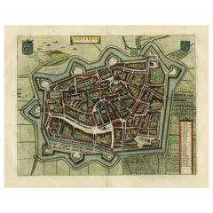
Antique map titled 'Leeuwerden de hooft stadt van Frislant. Leoverdia Metropolis Frisiae (…) 1603.' Very rare plan of Leeuwarden, Friesland, The Netherlands. With several carouches a...
Category

Antique 17th Century Maps

Materials

Paper

European Vintage Wristwatches Anker, Omega, Orion, Lanco Swiss, Chronometre
Located in Los Angeles, CA
Vintage and antique wristwatch collection. Total 23 watches . All of them in original condition. Leather bends. The watches are functional but needs...
Category

Vintage 1950s Swiss Mid-Century Modern Collectible Jewelry

Materials

Metal

Antique Brochure Weapon Catalogue for Pietro Beretta '1906'
Located in Langweer, NL
An original 1906 brochure catalogue for Pietro Beretta. A detailed catalogue offering many weapons available to purchase at the time. Incredibly rare, only a few later catalogues off...
Category

20th Century Arms, Armor and Weapons

Materials

Paper

Mid-20th Century Brutalist Iron Hanukkah Lamp Menorah by David Palombo
By David Palombo
Located in New York, NY
Hand forged, iron Hanukkah lamp Menorah in the style known as “Brutalism”, David Palombo, Jerusalem, Israel, circa 1950. David Palombo (1920-1966), was a sculptor and painter. He wa...
Category

Mid-20th Century Israeli Brutalist Religious Items

Materials

Iron

Mid-20th Century Israeli Silver Arts & Crafts Hanukkah Lamp Menorah
Located in New York, NY
Handmade silver Hanukkah lamp, Israel, circa 1940s. Beautiful Arts & Crafts Hanukkah lamp by I. Gurevitz. with great hand silver work with solid silver wires in the center, connecte...
Category

Mid-20th Century Israeli Arts and Crafts Religious Items

Materials

Silver

Map of Europe Highlighting Ancient and Modern Geographical Divisions (1794)
Located in Langweer, NL
Map of Europe Highlighting Ancient and Modern Geographical Divisions (1794). Germany, France, Italy, Spain, and the British Isles – Map by D’Anville (1794). This detailed 18th-cent...
Category

Antique 1790s Maps

Materials

Paper

Old Map of Guyana, Suriname and French Guiana with Paramaribo and Cayenne, c1760
Located in Langweer, NL
Description: Antique map titled 'Carte de la Guiane.' Antique map of the Guianas - present day Guyana, Suriname and French Guiana, including Paramaribo and Cayenne. Source unknown, to be determined. Artists and Engravers: Made by 'Jacques-Nicholas Bellin...
Category

Antique 1760s Maps

Materials

Paper

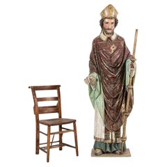
18thC Italian Oak & Polychrome Carved Bishop Statue
Located in Staffordshire, GB
Circa 1720 Large Early 18thC Italian Oak & Polychrome Carved Statue of a Bishop / Saint. Flat back with a secret panel which would have been used to hide gold. An exceptional exam...
Category

Antique 1710s Italian Sculptures and Carvings

Materials

Oak, Paint

Antique Engraving of the Statue of the Mythologic Hero Meleager, Rome. 1660
Located in Langweer, NL
Description: Antique print, titled: 'Meleager in Aedibus Pichinys.' Statue of Meleager in Rome. In Greek mythology, Meleager was a hero venerated in his temenos at Calydon in Aetolia. He was already famed as the host of the Calydonian boar hunt in the epic tradition that was reworked by Homer. From the 1660 Dutch edition of 'Icones et Segmenta Nobil. Signorum et Statuarum quae Romae extant' by Francois Perrier...
Category

Antique 1660s Prints

Materials

Paper

Santiago de Compostela Traditional Memorabilia Figure
Located in Barcelona, ES
Santiago de Compostela memorabilia metallic figure. Made Spain, circa 1950. In original condition, with minor wear consistent with age and use, preserving a beautiful patina. ...
Category

Vintage 1950s Spanish Modern Religious Items

Materials

Metal

Vintage Lucite Chess Set in Travel Case
Located in Palm Springs, CA
1970’s lucite chess set. The pieces are in a smoky brown and clear acrylic with a fitted case with a board built into the top. The case is vinyl I bel...
Category

Vintage 1970s American Games

Materials

Acrylic

Old Map of Persia, incl the Caspian Sea and Part of the Arabian Peninsula, 1726
Located in Langweer, NL
Antique map of Persia. It covers from the Gulf of Suez eastward to Ahmedabad (Amadabad) in modern day western India. This map, centered on Persia, includes the Caspian Sea and part of the Arabian...
Category

Antique 1720s Maps

Materials

Paper

Early 18th Century Map of Denmark in Old Coloring, Published in 1706
Located in Langweer, NL
Denmark. Schenk (Petrus), Dania Regnum Ducatus Holsatia. et Slesvicum Insulae Danicae et Provinciae Jutia Scania etc. Amsterdam, 1706, engraved reticulated map on thick paper with co...
Category

Antique Early 1700s Maps

Materials

Paper

Read More

Medal-Worthy Memorabilia from Epic Past Olympic Games

Get into the games! These items celebrate the events, athletes, host countries and sporting spirit.

Ahoy! You’ve Never Seen a Collection of Sailor Art and Kitsch Quite Like This

French trendsetter and serial collector Daniel Rozensztroch tells us about his obsession with objects related to seafaring men.

Pamela Shamshiri Shares the Secrets behind Her First-Ever Book and Its Effortlessly Cool Interiors

The sought-after designer worked with the team at Hoffman Creative to produce a monograph that beautifully showcases some of Studio Shamshiri's most inspiring projects.

Moroccan Artworks and Objects Take Center Stage in an Extraordinary Villa in Tangier

Italian writer and collector Umberto Pasti opens the doors to his remarkable cave of wonders in North Africa.

Montecito Has Drawn Royalty and Celebrities, and These Homes Are Proof of Its Allure

Hollywood A-listers, ex-pat aristocrats and art collectors and style setters of all stripes appreciate the allure of the coastal California hamlet — much on our minds after recent winter floods.

Whaam! Blam! Pow! — a New Book on Pop Art Packs a Punch

Publishing house Assouline and writer Julie Belcove have teamed up to trace the history of the genre, from Roy Lichtenstein, Andy Warhol and Yayoi Kusama to Mickalene Thomas and Jeff Koons.

The Sparkling Legacy of Tiffany & Co. Explained, One Jewel at a Time

A gorgeous new book celebrates — and memorializes — the iconic jeweler’s rich heritage.

What Makes a Gem-Encrusted Chess Set Worth $4 Million?

The world’s most opulent chess set, weighing in at 513 carats, is literally fit for a king and queen.

Recently Viewed

View All