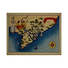
Entertainment Art

to
29
226
181
104
51
39
Overall Width
to
Overall Height
to
184
151
197
69
2
2
6
22
49
37
14
27
8
11
68
210
63
19
5
4
3
2
2
1
1
1
389
200
12
601
152,330
79,679
50,300
41,974
36,254
34,655
29,729
26,485
25,397
24,467
20,448
17,866
15,651
14,441
13,566
12,973
11,135
10,458
10,043
183
180
147
113
44
29
28
25
18
16
33
325
396
148
Art Subject: Entertainment
1943 original illustrated map of Cochinchine by Dylbert

1943 original illustrated map of Cochinchine by Dylbert

Located in PARIS, FR

The 1943 original illustrated map of Cochinchine by Dylbert is a striking example of cartographic artistry from a period steeped in global conflict and colonial influence. Created du...

Category

1940s Prints and Multiples

Materials

Linen, Paper, Lithograph

1941 original map "Les vins de Bordeaux - Loupiac, ..." by Larmat

1941 original map "Les vins de Bordeaux - Loupiac, ..." by Larmat

Located in PARIS, FR

In 1941, L. Larmat crafted an exquisite map titled Atlas de la France Vinicole: Les Vins de Bordeaux - Loupiac, Sainte-Croix-du-Mont, Ières Côtes de Bordeaux, Côtes de Bordeaux St. M...

Category

1940s Prints and Multiples

Materials

Paper, Lithograph

Map of the World - Original Etching - 1820

Map of the World - Original Etching - 1820

Located in Roma, IT

Map of the World is an Original Etching realized by an unknown artist of 19th century in 1820. Very good condition on two sheets of white paper joine...

Category

1820s Modern Figurative Prints

Materials

Etching

Map of Nubia and Abissinia - Etching by Antonio Zatta - 1784

Map of Nubia and Abissinia - Etching by Antonio Zatta - 1784

Located in Roma, IT

This Map of Nubia and Abissinia is an etching realized by Antonio Zatta in Venice in 1784. The state of preservation of the artwork is good expect for the worn paper with some littl...

Category

1770s Landscape Prints

Materials

Etching

Ancient Map of Senegal - Etching - 19th Century

Ancient Map of Senegal - Etching - 19th Century

Located in Roma, IT

Map of Senegal is an original etching realized by an anonymous engraver of the 19th Century. Printed in series of "France Pittoresque" at the top center. The state of preservation ...

Category

19th Century Figurative Prints

Materials

Etching

Map of Russia  - Original Etching - Late 19th Century

Map of Russia - Original Etching - Late 19th Century

Located in Roma, IT

This Map of Russia is an etching realized by an anonymous artist. The state of preservation of the artwork is good with some small diffused stains. Sheet dimension:27.5 x 44 At t...

Category

Late 19th Century Modern Figurative Prints

Materials

Etching

Map of Rouen - Original Etching - 19th Century

Map of Rouen - Original Etching - 19th Century

Located in Roma, IT

Map of Rouen is an original etching realized by an Anonymous engraver of the 19th Century. Printed within the series of "France Pittoresque". The state of preservation of the artwo...

Category

19th Century Figurative Prints

Materials

Etching

Map of Vendée - Etching - 19th Century

Map of Vendée - Etching - 19th Century

Located in Roma, IT

Map of Vendée is an etching realized by an anonymous engraver of the 19t century. Printed in series of "France Pittoresque" at the top center. The state of preservation of the artw...

Category

19th Century Modern Figurative Prints

Materials

Etching

original lithograph

original lithograph

By Samuel M. Adler

Located in Henderson, NV

Medium: original lithograph. This lithograph was printed in 1955 for the "Improvisations" portfolio, and published by the Artists Equity Association of New York in an edition of 2000...

Category

1950s Prints and Multiples

Materials

Lithograph

An original poster featuring an illustrated map of Tenerife - La Lucha

An original poster featuring an illustrated map of Tenerife - La Lucha

Located in PARIS, FR

A beautiful poster featuring an illustrated map of Tenerife or Tenerife, an island in Spain that forms part of the Canary Islands archipelago in the Atlantic Ocean. It is not only t...

Category

1950s Prints and Multiples

Materials

Paper, Lithograph

Ship - Red Pen Drawing on Paper - Mid 20th Century

Ship - Red Pen Drawing on Paper - Mid 20th Century

Located in Roma, IT

Ship is an original red Pen drawing on paper, realized by an anonymous artist in 1982. Titled, signed and dated in pencil on lower margin, signature not completely readable ( readabl...

Category

Mid-20th Century Modern Figurative Drawings and Watercolors

Materials

Permanent Marker

original lithograph

original lithograph

Located in Henderson, NV

Medium: original lithograph. This lithograph was printed in 1958 for the "Improvisations" portfolio, published by the Artists Equity Association of New York on the occasion of the 19...

Category

1950s Prints and Multiples

Materials

Lithograph

original lithograph

original lithograph

By Anton Refregier

Located in Henderson, NV

Medium: original lithograph. This lithograph is from the rare 1953 "Improvisations" portfolio, published by the Artists Equity Association of New York on the occasion of the 1953 Spr...

Category

1950s Prints and Multiples

Materials

Lithograph

1864 Original illustrated planisphere - World Map - Geography

1864 Original illustrated planisphere - World Map - Geography

Located in PARIS, FR

Immerse yourself in the epic journey of the past with the Illustrated Historical Planisphere of 1864 by Charpentier! 🗺️ This cartographic treasure transports you through the intrica...

Category

1860s Prints and Multiples

Materials

Linen, Paper, Lithograph

Map of Edgartown, Martha's Vineyard

Map of Edgartown, Martha's Vineyard

Located in New York, NY

Original map of Edgartown, Martha's Vineyard with recent hand-coloring, 1938. Light toning to edges; has original holes punched in left edge. From "Massach...

Category

1930s Prints and Multiples

Materials

Paper

John Speede Map The Countye of Monmouth

John Speede Map The Countye of Monmouth

By John Speed

Located in London, GB

To see our other views and maps of England - including London, Oxford and Cambridge, scroll down to "More from this Seller" and below it click on "See all from this Seller" - or send...

Category

17th Century Realist Landscape Prints

Materials

Engraving

Graphis International Poster December 1947, magazine cover design by E. Davis

Graphis International Poster December 1947, magazine cover design by E. Davis

Located in London, GB

E Davis Graphis International Poster, December 1947 Gouache 30 x 23 cm Signed to reverse Provenance: The family of A. E. Halliwell Graphis is a renowned international journal of vi...

Category

1940s Art Deco Figurative Paintings

Materials

Gouache

Wonderground Map of London by MacDonald 'Max' Gill c. 1924 original poster

Wonderground Map of London by MacDonald 'Max' Gill c. 1924 original poster

By "Leslie MacDonald ""Max"" Gill"

Located in London, GB

To see our other original vintage posters and views of London (including original paintings), scroll down to "More from this Seller" and below it click on "See all from this Seller" ...

Category

1920s Modern Landscape Prints

Materials

Lithograph

An Intimate Mappe Of Ye Fabulous L.I. North Shore

An Intimate Mappe Of Ye Fabulous L.I. North Shore

Located in Bristol, CT

Map Sz: 19 3/4"H x 23 3/4"W Frame Sz: 22 1/8"H x 26 1/8"W w/ Prominent Family names: Bostwick Chrysler Field Harriman Hearst Hitchcock Iglehart Milburn Morgan Paley Phipps Rooseve...

Category

21st Century and Contemporary More Prints

Materials

Glass, Wood, Paper

John Speede, Map of the County of Surrey, described and divided into hundreds

John Speede, Map of the County of Surrey, described and divided into hundreds

By John Speed

Located in London, GB

To see our other views and maps of England - including London, Oxford and Cambridge, scroll down to "More from this Seller" and below it click on "See all from this Seller" - or send us a message if you cannot find the view you want. John Speed/Speede (1551/2-1629) 
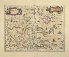
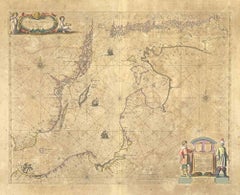
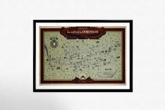
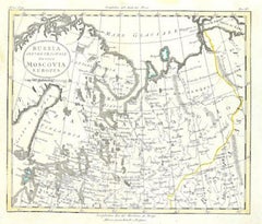
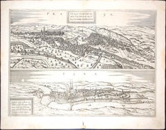
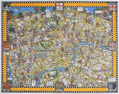
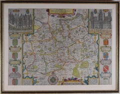
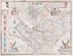
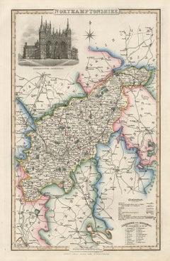
The County of Surrey Described and Divided into Hundreds 
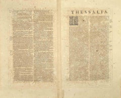
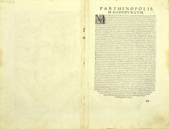
Engraving with later hand colouring and text to the reverse.  Dated to c.1650 36 x 49 cm Probably the most famous early English mapmaker, John Speed's early life is somewhat of an enigma. He is believed to have trained as a rolling-press printer, but he was at heart an historian granted a sinecure in the Customs House by Queen Elizabeth to indulge his passion, later becoming a Fellow of the Society of Antiquaries. His first maps were historical, of the Holy Land 'Canaan as it was Possessed both in Abraham and Israels Dayes' and of England and Ireland recording 'all their Civill Warres since the Conquest'. In 1611 he published his 'Hostory of Great Britaine' which he regarded as his magnum opus, but it was the companion atlas 'Theatre of the Empire of Great Britaine' that - as the first printed atlas of Great Britain - sealed his reputation. William Rogers engraved the first map, 'the County Palatine of Chester' in about 1600, but following his untimely death the task of engraving was passed to Jodocus Hondius of Amsterdam. By 1612 the atlas was complete, the maps famed for their decorative elements. Many have town plans - Britain's first series of such plans - and descriptive text was printed to the reverse until the 1676 edition. Later printings (up until 1770) were issued without this text. By 1627 it has become a part of a world atlas 'Prospect of the Most Famous Parts of the World'. During the 17th century the plates passed through the hands of a series of publishers, the 1676 edition of Thomas Bassett and Richard Chiswell being regarded as its high point with the inclusion for the first time of a series of important maps. For the first half of the eighteenth century they were firmly established in the hands of the Overton family. 
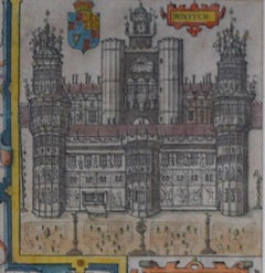
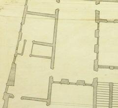
This particular edition originally featured in The Theatre Of The Empire Of Great Britaine. It features attractive inset views of the long-since destroyed Richmond...

Category

17th Century Realist Landscape Prints

Materials

Engraving

Till the bottle runs dry - Contemporary, Portrait, Women, Polaroid, Nude

Till the bottle runs dry - Contemporary, Portrait, Women, Polaroid, Nude

By Kirsten Thys van den Audenaerde

Located in Morongo Valley, CA

'Till the bottle runs dry', 2020 20x20cm, Edition 1/7 plus 2 Artist Proofs, digital C-Print based on a Polaroid, not mounted. Signed on the back and with certificate. Artist inve...

Category

2010s Contemporary Color Photography

Materials

Archival Paper, Photographic Paper, C Print, Color, Polaroid

New South Wales, Australia, antique mid 19th century engraved John Tallis map

New South Wales, Australia, antique mid 19th century engraved John Tallis map

Located in Melbourne, Victoria

'New South Wales' With decorative border surrounds and vignettes of 'Sydney Cove'. 'The Murray' and 'Xanthorrhea'. 'Drawn and engraved by J Rapkin'. Published by John Tallis. 375m...

Category

1840s Victorian Landscape Prints

Materials

Engraving

Berkshire, English County Antique map, 1847

Berkshire, English County Antique map, 1847

By Isaac Slater

Located in Melbourne, Victoria

Steel-engraved map with original outline colouring by Isaac Slater. A detailed engraved map of the English county with title, scale, and key. Decorated with an uncoloured engraved v...

Category

19th Century Naturalistic Landscape Prints

Materials

Engraving

Huntingdonshire, English County Antique map, 1847

Huntingdonshire, English County Antique map, 1847

By Isaac Slater

Located in Melbourne, Victoria

Steel-engraved map with original outline colouring by Isaac Slater. A detailed engraved map of the English county with title, scale, and key. Decorated with an uncoloured engraved vi...

Category

19th Century Naturalistic Landscape Prints

Materials

Engraving

Nottinghamshire, English County Antique map, 1847

Nottinghamshire, English County Antique map, 1847

By Isaac Slater

Located in Melbourne, Victoria

Steel-engraved map with original outline colouring by Isaac Slater. A detailed engraved map of the English county with title, scale, and key. Decorated with an uncoloured engraved vi...

Category

19th Century Naturalistic Landscape Prints

Materials

Engraving