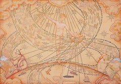
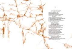
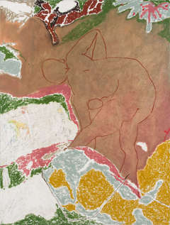
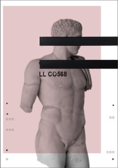
Three in One
By Allen Jones
Located in Zug, CH
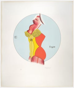
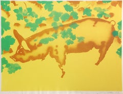
ALLEN JONES (1937) Three in One 1971 Color serigraphy 48.5 x 46 cm 19.09 x 18.11 inches Number 70 of 75 Signed and dated on the lower right
Category
20th Century Prints and Multiples
Materials
Paper
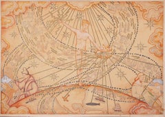
Three in One
By Allen Jones
Located in Zug, CH
ALLEN JONES (1937) Three in One 1971 Color serigraphy 48.5 x 46 cm 19.09 x 18.11 inches Number 70 of 75 Signed and dated on the lower right
Paper
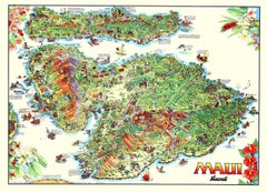
Maui, Hawaii — Kim Forrest, 1992 Illustrated Map Poster, Offset Lithograph
Located in Spokane, WA
Titled Maui, Hawaii, and created in 1992, this illustrated map by Kim Forrest presents the island through a lively, highly detailed visual language that merges cartography with story...
Offset
$80Sale Price|36% Off
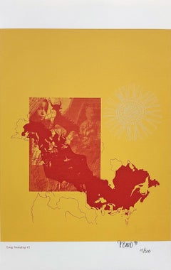
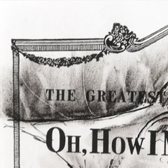
LONG STANDING #2
Located in Aventura, FL
Lithograph on paper. Sheet size 19 x 12 inches. Hand signed, dated and numbered by the artist. Edition of 300. Certificate of Authenticity Included. Artwork in Excellent Conditi...
Paper, Lithograph
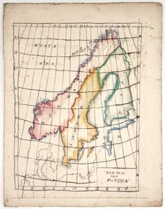
Map of Norway and Sweden
Located in Middletown, NY
Watercolor and ink on heavy gauge watercolor paper, 12 x 9 1/4 inches (305 x 235 mm), the full sheet. In very good condition with some minor age tone and scattered light areas of dis...
Watercolor
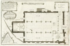
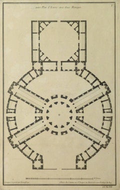
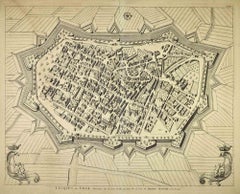
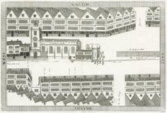
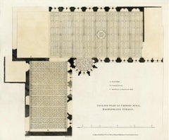
The plan of St. Martin's Church, St. Martin in the Fields
Located in Middletown, NY
London: Society of Antiqauries London, 1744. Engraving on buff wove paper with a large heraldic watermark with Strasbourg lily with a crown and shied and the letters LVG, 9 1/2 x 14 ...
Engraving, Handmade Paper
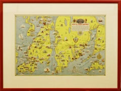
"Rhode Island Map, 1933"
Located in Bristol, CT
Classic c1933 colour (12 fold) red framed map of Rhode Island designed by H.W. Hetherington from Narragansett Bay to Buzzard's Bay Map Sz: 17 3/8"...
Lithograph
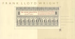
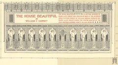
Frank Lloyd Wright 'The House Beautiful' Offset Print, 1992, Unframed
By Frank Lloyd Wright
Located in Brooklyn, NY
Original exhibition poster created for a special tribute to architect Frank Lloyd Wright on the 125th anniversary of his birth. Sponsored by the Guggenheim Museum in 1992, the poster...
Offset
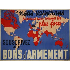
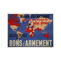
1939 Powerful WWII french poster - Subscribe to Armament Bonds
Located in PARIS, FR
Designed by J. Kap in 1939, this powerful poster titled "Souscrivez aux Bons d’Armement" (Subscribe to Armament Bonds) was a key piece of French wartime propaganda at the dawn of Wor...
Paper, Lithograph
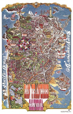
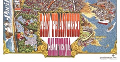
Original San Francisco, California vintage fun map poster Henry Hinton
Located in Spokane, WA
Original San Francisco, California fun map vintage poster 1970. Archival linen backed in very fine condition, ready to frame. -Artist: Henry Hinton I don’t know how much more you could include in this detailed fun map of San Francisco...
Offset
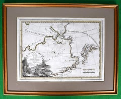

Le Coste Nord Ovest Dell' America E Nord Est Dell' Asia Delineate Sulle Ultime O
Located in Bristol, CT
Map Sz: 14 1/2"H x 19 7/8"W Frame Sz: 21"H x 26 3/8"W A fine example of Cassini's 1798 map of Alaska, the Bering Strait, and Siberia. Cassini issued this map in his 1798 atlas to illustrate the discoveries made by James Cook. Cook was the first to accurately chart the Alaskan coastline and provide a detailed mapping of the Aleutian Islands. Cook's zigzagging route is shown as he skirts the Aleutian Islands, passes through the Bering Strait into the Arctic Ocean, and then turns back to sail south along the Siberian Coast. Here the Aleutians are collectively identified as Isole Alessiane, though many of the original islands...
Paper

$2,161
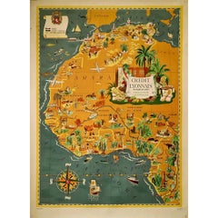
1939 original map Lucien Boucher Crédit Lyonnais Afrique Du Nord Union Française
Located in PARIS, FR
The 1939 original map by Lucien Boucher, commissioned by Crédit Lyonnais, is a remarkable piece of cartographic art that highlights the regions of North Africa within the French Unio...
Paper, Lithograph
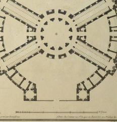
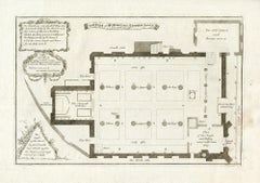
Antique French Copper Engraving - Horse Stables
Located in Houston, TX
Crisp antique copper engraving of a unique floor plan of French horse stables from Recueil d'Architecture, 1780. Original artwork on paper displayed on a...
Ink, Paper
'Study for a Mural', Maquette, Chicago, Alfred Stieglitz, Armory Show, PAFA, NAD
By Daniel Putnam Brinley
Located in Santa Cruz, CA
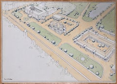
Signed lower right, 'D. Putnam Brinley' for Daniel Putnam Brinley (American, 1879–1963) and dated 1932. Artist note, lower left, 'Scale 1'' - 1'. ' American muralist and painter Dan...
Watercolor, Gouache, Illustration Board
$80Sale Price|36% Off
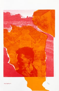
STEP LIGHTLY #3
Located in Aventura, FL
Lithograph on paper. Sheet size 19 x 12 inches. Hand signed, dated and numbered by the artist. Edition of 300. Certificate of Authenticity Included. Artwork in Excellent Conditi...
Paper, Lithograph

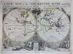
New Map of the Terraqueous Globe - WORLD MAP - CALIFORNIA AS AN ISLAND
By Edward Wells
Located in Santa Monica, CA
EDWARD WELLS (British 1667- 1727) A NEW MAP of the TERRAQUEOUS GLOBE - according to the latest Discoveries and most general Divisions of it into CONTINENTS and OCEANS, 1700-01 (Shirley 609) Engraved by Michael Burghers, Oxford. Hand-colored, Platemark 14 1/4 x 20 1/8 inches. Central cartouche flanked by figures representing the continents with dedication to William, Duke of Gloucester...
Engraving
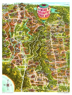
Original Wine Country Tour Map vintage California fun map, linen-backed.
Located in Spokane, WA
Original Wine Country Tour Map, archival linen backed and ready to frame. Very fine condition, Grade A-. The fold marks were restored during the backing process. No paper loss a...
Offset
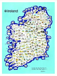
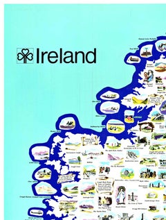
Original Ireland Pictorial Vintage Poster Travel Map linen backed
Located in Spokane, WA
Original Ireland Pictorial Map, archival linen-backed, Grade A, ready to frame. This poster has no restoration, vibrant colors, and numerous details. Browne and Nolan Limited printed...
Lithograph
(after) Jane Wilson - lithograph
By Jane Wilson
Located in Henderson, NV
Medium: lithograph. From the "In Memory of My Feelings" portfolio, printed in 1967 on Mohawk Superfine Smooth paper in a limited edition of 2500 and published in New York by The Muse...
Lithograph
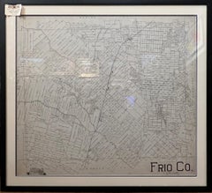
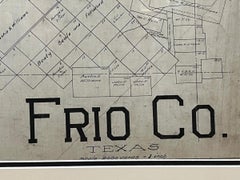
TEXAS FRIO COUNTY MAP PEARSALL TEXAS AREA 1870S-1910 ORIGINAL HAND DRAWN
Located in San Antonio, TX
Texas County Maps 1870s-1910 Image Size: 37 x 40 Frame Size: 43 x 47 Medium: Original Hand Drawn Ink "Frio County" Texas County Map Early original hand drawn Texas County Maps (1870s...
Ink
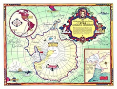
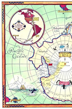
Original Byrd Map of Antartic Expedition 1934 vintage poster map
Located in Spokane, WA
Original Authorized Map of the Second BYRD Antarctic Expedition vintage poster map. Printed in 1934 by G.F. Corp. Artist: George Annand. Authentic 1934 Print: This is the genuin...
Offset
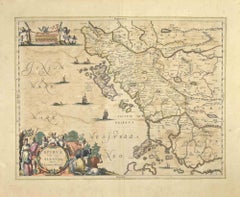
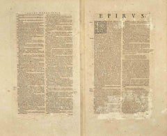
Epirus Albania - Etching by Johannes Janssonius - 1650s
Located in Roma, IT
Epirus Albania is an ancient map realized in 1650 by Johannes Janssonius (1588-1664). Good conditions. From Atlantis majoris quinta pars, Orbem maritimum [Novus Atlas, volume V: ca...
Etching

Da Te Lontano (Far From You) - Screen Print by Ennio Pouchard - 1973
Located in Roma, IT
Da Te Lontano from Diecicomeleditadiduemani is a color silk-screen print on acetates, realized in 1973 by the artist Ennio Pouchard (1928). Signed on plate in the lower right. ...
Screen
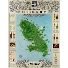
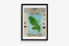
Circa 1960 original advertising poster, Old Nick: Martinique, L'île du Rhum
Located in PARIS, FR
This original advertising poster, Old Nick: Martinique, L'île du Rhum, serves as a vibrant celebration of the rich heritage of rum production on the island of Martinique. The poster ...
Paper, Lithograph
Signed Feminist LGBTQ+ Colorful Ink on Paper Drawing - Fantasia 418.029
Located in New York, NY
Linda Stein, Fantasia 418.029 - Signed Feminist LGBTQ+ Colorful Ink, Color Pencil, and Graphite on Paper Drawing Fantasia 418.029 is from Linda Stein's Profiles Notation series--d...
Paper, Ink, Color Pencil, Graphite

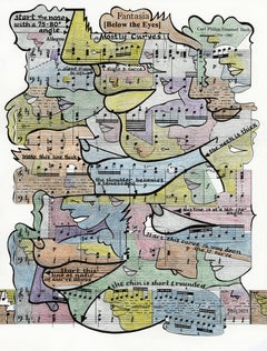
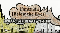
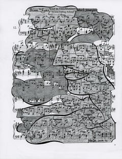
Each Moment We're Apart - Abstract Figurative Mixed Media Surrealist Art
Located in Los Angeles, CA
Robert Lebsack creates artworks using mixed media with ink, acrylic, and charcoal on archival copies of newspapers, textbooks, and sheet music. As a visionary artist, Lebsack weaves ...
Charcoal, Ink, Mixed Media, Acrylic, Archival Paper

$3,000
Signed Feminist LGBTQ+ Ink Graphite on Paper Drawing - Profile Notation 418.013
Located in New York, NY
Linda Stein, Profile Notation 418.013 - Signed Feminist LGBTQ+ Ink and Graphite on Paper Drawing Profile Notation 418.013 is from Linda Stein's Profiles series--drawings, collages ...
Paper, Ink, Graphite
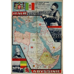

Circa 1935 propaganda poster by W. Seghers - Abyssinie
Located in PARIS, FR
This striking circa 1935 propaganda poster, created by W. Seghers, reflects the intense political climate surrounding Italy’s imperial ambitions...
Paper, Lithograph
$998
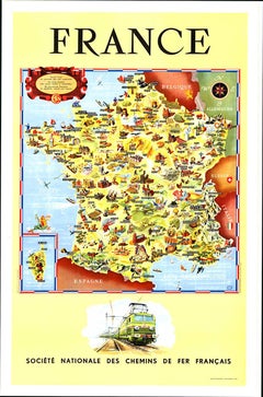
Original Societe Nationale des Chemin Map France, 1953 vintage poster on linen
Located in Spokane, WA
Original French vintage travel poster: "FRANCE, Société Nationale des Chemins de Fer Français." Printed in France by the French National Railroads. Original linen-backed poster; read...
Lithograph
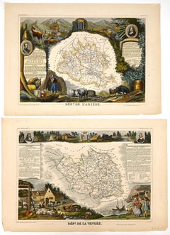
Dépt. De L’Ariège, & Dépt. De la Vendée, from Atlas National de France Illustré
By Louis Francois Couche
Located in Middletown, NY
Two (2) historiated engraved maps, each 11 1/4 x 16 7/16 inches (285 x 418 mm) with handcoloring, on wove paper, the latter engraved by C. Smith after Couché fils, published by Combe...
Watercolor, Handmade Paper, Engraving
Landscape - Lithograph by Franco Marzilli - 1980s
Located in Roma, IT
Etching hand colored realized by Franco Marzilli. Hand signed and unnumbered. Very Good condition. This delicate etching by Italian artist Franco Marzilli captures the lyricism o...
Lithograph
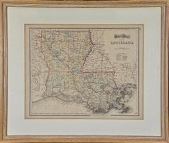
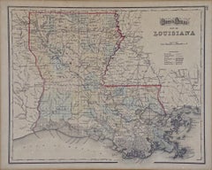
Louisiana: A Framed 19th Century Map by O.W. Gray
Located in Alamo, CA
This framed 19th century map of the Louisiana territory was published in "Gray's Atlas of the United States with General Maps of the World, accompanied by Descriptions Geographical, Historical, Scientific and Statistica" published in 1873 in Philadelphia by O.W. Gray and Son and Stedman, Brown and Lyon. It is a highly detailed map of Louisiana...
Engraving
Map of Lucca - Etching by Pierre Mortier - Early 18th Century
Located in Roma, IT
Map of Lucca is an etching realized by Pierre Mortier in the early 18th Century Good condition.
Etching
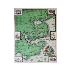
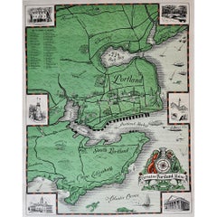
Original poster made in the 1950's of the Greater Portland Maine
Located in PARIS, FR
Original cartographic poster made in the 1950's that shows us all the monuments and different places of historical importance in the city of Portland. Portland, also known as Portla...
Linen, Paper, Lithograph
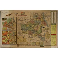
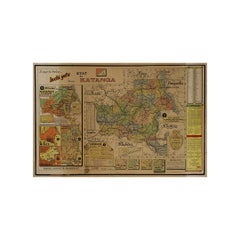
Original 1960 Map by Louis Dressen État du Katanga Congo
Located in PARIS, FR
This original 1960 poster by Louis Dressen, titled État du Katanga, is a rare and powerful visual document from one of the most turbulent moments in post-colonial African history. Pu...
Paper, Lithograph
$898
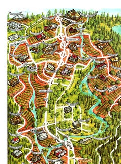
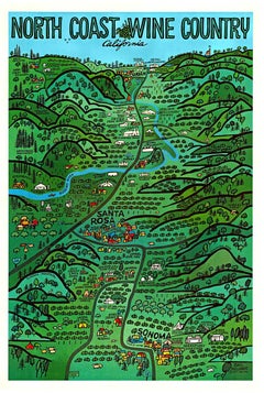
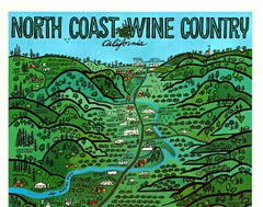
Original North Coast Wine Country California vintage vineyard travel poster
Located in Spokane, WA
Original North Coast Wine Country California vintage vineyard travel poster. The artist Earl Thollander. Size 24.25” x 30”. Archival linen backed in good condition. Grade A- A repaired tear along the bottom was restored during linen backing and is inconspicuous. Celebrate Your Passion for Wine: Show off your love for wine culture while honoring California's North Coast’s rich history as one of the world’s premier wine regions. This poster represents the artistry and heritage behind each glass of wine you enjoy. Capture the Essence of California Wine Culture in 1975 Transport yourself to the golden era of wine-making with this authentic vintage 1975 North Coast Wine Country poster, a must-have for those who love wine, history, and timeless art. Featuring a design that exudes classic California vineyard...
Lithograph
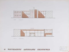
Design for Modernist Brutalist Institute IV mid-century architectural drawing
Located in London, GB
To see our other Architectural Drawings, scroll down to "More from this Seller" and below it click on "See all from this Seller"; you can also search for other drawings by this artist. V A Hards...
Ink, Watercolor, Pen
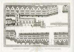
Map of Cheapside, as it Appeared in the Year 1585
Located in Middletown, NY
Bird's eye view of the old buildings in West Cheap (Cheapside) as they appeared in 1585, from Londina Illustrata. London: Robert Wilkinson, 1814 Engraving on buff wove paper, 11 ...
Handmade Paper, Engraving

$1,850
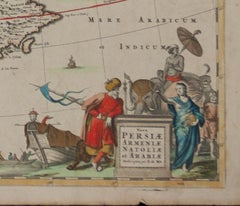
Persiae, Armeniae, Natoliae et Arabiae Descriptio per Frederick deWit 1666 map
Located in Paonia, CO
Map of Persiae, Armeniae, Natoliae et Arabiae Descriptio per F de Wit 1688 engraving from: Atlas Contractus Orbis Terrarum Praecipuas ac Novissimas Complectens Tabulas. Amsterdam, N. Visscher, 1656-77. (Koeman III, Vis5-8) This highly decorative map of the Middle East is by the Dutch engraver, publisher, and map seller...
Engraving

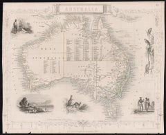
Australia, Tallis antique map, 1851
Located in Melbourne, Victoria
'Australia' With decorative border surrounds and vignettes including a view of Sydney, Kangaroos, Natives of Australia Felix, Australian Parrots and Cockatoos and Natives of the Tri...
Engraving
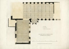
Ceiling plan of Crosby Hall, Bishopsgate Street
Located in Middletown, NY
Robert Wilkinson, 1816. Copperplate engraving on buff wove paper with hand coloring in watercolor, 10 7/8 x 13 /4 inches (275 x 336 mm), full margins. In good condition with some sc...
Handmade Paper, Engraving, Watercolor
Clam Digger
By Otis Huband
Located in Dallas, TX
This painting is included in the exhibition "Otis Huband: Recent Work," June 7 - July 19, 2014. Valley House Gallery is honored to present our first exhibition for Houston artist ...

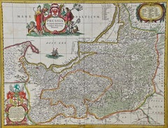
A Hand Colored 17th Century Janssonius Map of Prussia: Poland, N. Germany, etc.
Located in Alamo, CA
An attractive hand-colored copperplate engraved 17th century map of Prussia entitled "Prussia Accurate Descripta a Gasparo Henneberg Erlichensi", published in Amsterdam by Joannes Janssonius in 1664. This very detailed map from the golden age of Dutch cartography includes present-day Poland, Latvia, Lithuania, Estonia and portions of Germany. This highly detailed map is embellished by three ornate pink, red, mint green and gold...
Engraving
$1,200
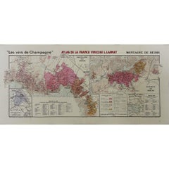
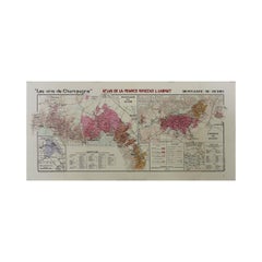
1944 original map "Les vins de Champagne – Montagne de Reims" by Louis Larmat
Located in PARIS, FR
The 1944 original map "Atlas de la France Vinicole – Les vins de Champagne – Montagne de Reims" by Louis Larmat is an exquisite piece of cartography that reflects both the history an...
Paper, Lithograph

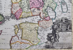
Sweden and Adjacent Portions of Scandinavia: A Hand-colored 18th C. Homann Map
Located in Alamo, CA
This hand-colored copper-plate map of Sweden and adjacent portions of Scandinavia entitled "Regni Sueciae in Omnes suas Subjacentes Provincias accurate divisi Tabula Generalis" was c...
Engraving

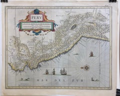
PERU
By Johannes Jansson
Located in Santa Monica, CA
JOHANNES JANSSON (1588 - 1664) PERU, engraving with early coloring. Platemark 15 1/8 x 19 3/8 inches, sheet 17 x 20 1/2 A nice example of one of the earliest maps of Peru. From the ...
Engraving
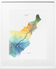
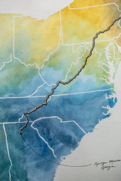
Appalachian Trail Map: Contemporary Pen and Ink with Acrylic Wash
By Sarah Kaizar
Located in Philadelphia, PA
"Appalachian Trail Map" is an original pen and ink, acrylic wash artwork by Sarah Kaizar measuring 30"h x 24"w framed. It’s an off-beat, diverse...
Ink, Paper, Acrylic, Pen

Shade of a Tree, Signed Modern Screenprint by Shoichi Ida
By Shoichi Ida
Located in Long Island City, NY
Shade of a Tree Shoichi Ida, Japanese (1941–2006) Date: 1970 Screenprint, signed, titled, numbered and dated in pencil Edition of 1/30 Image Size: 21.25 x 27.25 inches Size: 22 x 28 ...
Screen

$364Sale Price|20% Off
Finely Detailed British Watercolor Topographical of Civic Centre Madras
Located in Cirencester, Gloucestershire
Medium: Watercolour on paper, unframed Size: 10 inches (height) x 14 inches (width) Signed: Yes Condition: Sound condition, with some minor signs of foxing visible Provenance: Privat...
Watercolor
Barbarga - Etching by Johannes Janssonius - 1650s
Located in Roma, IT
Barbarga is an ancient map realized in 1650 by Johannes Janssonius (1588-1664). Good conditions. From Atlantis majoris quinta pars, Orbem maritimum [Novus Atlas, volume V: carte ma...
Etching
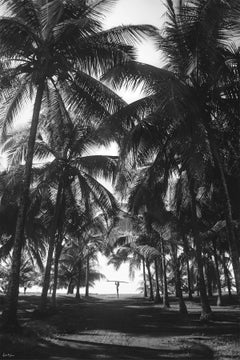
Single and Ready to Slide
Located in New York, NY
It doesn’t matter if it’s Bermuda, Hawaii or Costa Rica, if there are palm trees and crystal clear water you’re daydreaming of hopping on the next flight out. However, your daily lif...
Archival Pigment
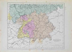
South Germany - Lithograph - 1872
Located in Roma, IT
South Germany is a map realized by an artist during the 19th century. Lithograph, printed in 1872 by Milliam Mackenzie, London. Good condition.
Lithograph
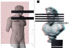
Untitled IX and VIII, Diptych. From The Balance Series
Located in Miami Beach, FL
With Balance the artist starts exploring more deeply the boundaries of the photographic media by mixing it with different techniques on a very traditional subject (classic sculptures...
Acrylic, Archival Pigment, Paper, Ink, Mixed Media
Indie - II Sheet
Located in Roma, IT
Etching hand colored realized by Antonio Zatta in 1785, and published by G. Pitteri. It depicts the Eastern Indian Ocean & its islands. Southern India, Sri Lanka, the Maldives, The ...
Etching
$3,000
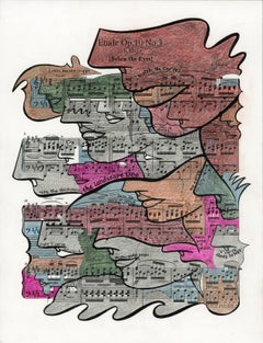
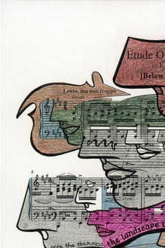
Signed Feminist LGBTQ+ Colorful Ink on Paper Drawing - Etude Op. 10 No. 418.032
Located in New York, NY
Linda Stein, Etude Op. 10 No. 418.032 - Signed Feminist LGBTQ+ Colorful Ink, Color Pencil, and Graphite on Paper Drawing Etude Op. 10 No. 418.032 is from Linda Stein's Profiles No...
Paper, Ink, Color Pencil, Graphite
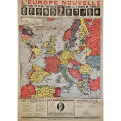
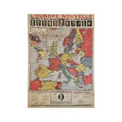
Original poster, titled “L’Europe Nouvelle” - political map of Europe
Located in PARIS, FR
This fascinating original poster, titled “L’Europe Nouvelle”, presents a vivid political map of Europe and the world as reshaped by the Treaty of Versailles, signed in 1919 at the co...
Linen, Paper, Lithograph

L'Herault, France. Antique map of a French department, 1856
Located in Melbourne, Victoria
'Dept. de Saone et Loire', steel engraving with original outline hand-colouring., 1856, from Levasseur's Atlas National Illustre. This area is home to a wide variety of vineyards a...
Engraving
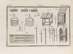
Ceraria - Etching - 18th Century
Located in Roma, IT
Etching realized in 19th century in Italy, showing the technologies and methodologies in vogue at the time for managing production in various manufacturing plants. Good condition wi...
Etching
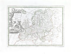
Map of Europe
Located in Roma, IT
Etching hand colored realized by Giovanni Maria Cassini in 1788. Table from "Nuovo Atlante Geografico Universale", published in Rome in 1788 at Calcografia Camerale. Very good cond...
Etching
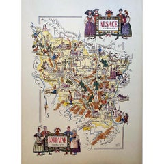
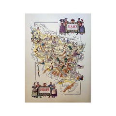
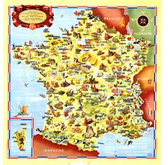
Jacques Liozu's 1951 illustrated map of Alsace and Lorraine in France
Located in PARIS, FR
Jacques Liozu's 1951 illustrated map of Alsace and Lorraine is a remarkable work of cartography that blends art and geography to offer a poetic and moving vision of these emblematic ...
Paper, Lithograph
$250Sale Price|50% Off
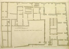
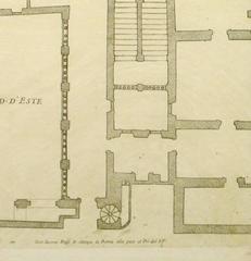
Antique Italian Engraving - Cardinal Este Palace
Located in Houston, TX
Over 350 year old antique copper engraving of the floor plan to the Palace of Cardinal Este located in Tivoli, Italy by Italian Giovanni Giacomo de Rossi, 1650. Original artwork on ...
Ink, Paper