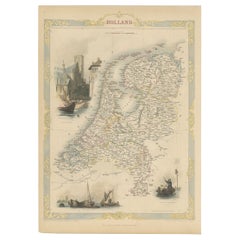
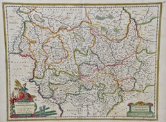
Antique Map of Holland with Colorful Vignettes, 1851
Located in Langweer, NL
Antique map titled 'Holland'. Decorative map of Holland. Includes vignettes of Rotterdam, Dutch
Category
Antique 19th Century Maps
Materials
Paper
Antique Map of Holland with Colorful Vignettes, 1851
Located in Langweer, NL
Antique map titled 'Holland'. Decorative map of Holland. Includes vignettes of Rotterdam, Dutch
Paper
$179Sale Price|20% Off
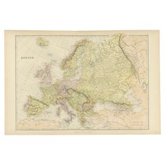
Colorful Detailed Antique Map of Europe, Published in 1882
Located in Langweer, NL
"The Antique Map of Europe from 'The Comprehensive Atlas and Geography of the World,' published in
Paper
$161Sale Price|20% Off
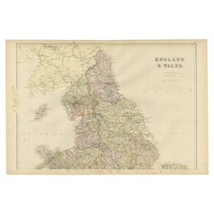
Colorful Detailed Antique Map of England and Wales, 1882
Located in Langweer, NL
Explore the Historic Splendor of 'England and Wales' with this Antique Map! Part of a distinguished
Paper
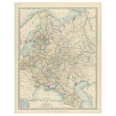
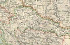
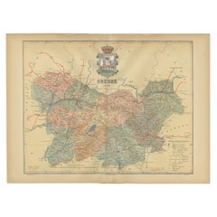
Antique Map of European Russia, 1903, with Colorful Provincial Boundaries
Located in Langweer, NL
Title: Antique Map of European Russia, 1903, with Colorful Provincial Boundaries Description: This
Paper
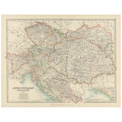
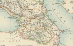
Antique Map of the Austro-Hungarian Monarchy, 1903, with Colorful Borderlines
Located in Langweer, NL
Title: Antique Map of the Austro-Hungarian Monarchy, 1903, with Colorful Provincial Borders
Paper
$161Sale Price|20% Off
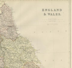
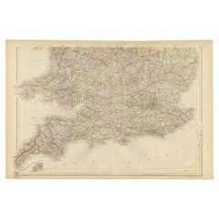
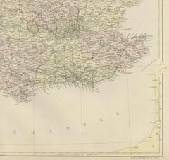
Colorful Detailed Antique Map of England and Wales (South Part), 1882
Located in Langweer, NL
Map! This map provides a vivid portrayal of the captivating landscapes and cultural heritage of the
Paper
$236Sale Price|20% Off
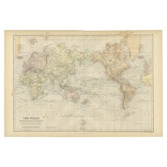
Colorful Detailed Antique Map of The World on Mercators Projection, 1882
Located in Langweer, NL
The 'World of Mercator's Projection' is a map with a stunning portrayal of global geography and
Paper
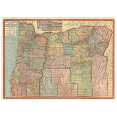
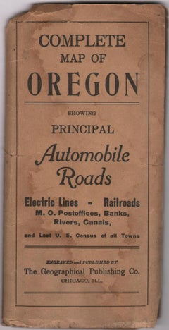
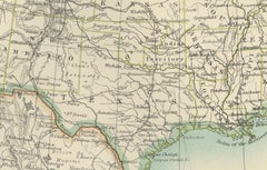
Colorful 1915 Road Map of Oregon with Portland Inset & Index – Geographical Pub.
Located in Langweer, NL
Colorful 1915 Road Map of Oregon with Portland Inset & Index – Geographical Pub. Description: This
Paper
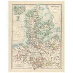
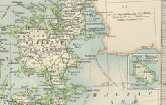
Antique Map of Denmark and German Empire Regions, 1903, Intricate and Colorful
Located in Langweer, NL
Title: Antique Map of Denmark and German Empire Regions, 1903, Intricate and Colorful Description
Paper
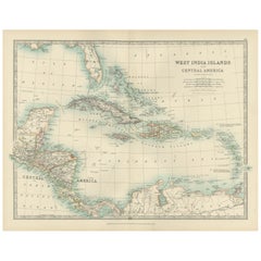

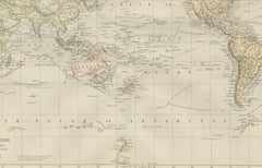
Map of the West India Islands and Central America – Colorful 1903 Engraving
Located in Langweer, NL
Map of the West India Islands and Central America – Colorful 1903 Engraving This vibrant engraved
Paper
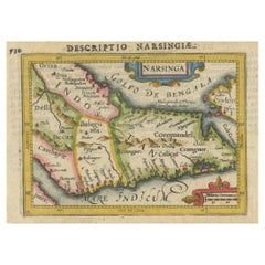
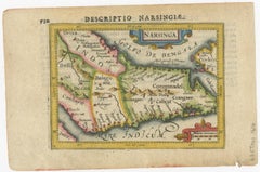
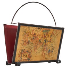
Colorful and Decorative Miniature Map of India, Ceylon by Bertius 1616
Located in Langweer, NL
Old 17th century miniature antique map of India - Ceylon from the 1616 edition of Jadocus Hondius
Paper

$445Sale Price|20% Off
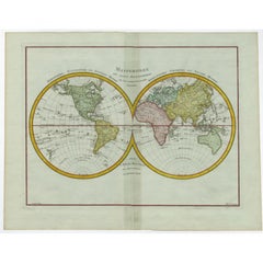
Original Engraved Antique Map of the World, Colorful and Decorative, C.1780
By Pierre François Tardieu
Located in Langweer, NL
Antique map titled 'Mappemonde en Deux Hemispheres ou l'on a Indique les Nouvelles Decouvertes
Paper

$179Sale Price|20% Off
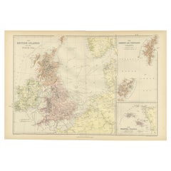
Colorful Detailed Antique Map of The British Islands and `The North Sea, 1882
Located in Langweer, NL
Discover 'The British Islands and The North Sea' Map with Insets of Orkney, Shetland, and Channel
Paper
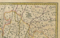
Map of Blaisois by Janssonius, 1633, Decorative Antique Map of Loire Valley
Located in Langweer, NL
and colorfully embellished map titled 'Description du Blaisois' was published in 1633 by Johannes
Paper
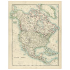
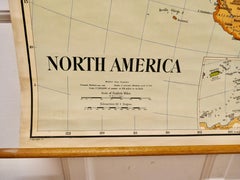
Explore North America in 1903 - Intricately Detailed Antique Map
Located in Langweer, NL
North America, 1903 - A Colorful Historical Map with Detailed Borders This attractive map of North
Paper
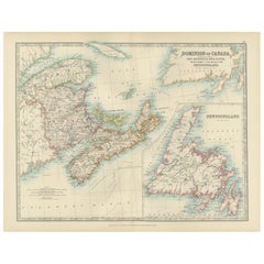
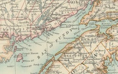
Canada Dominion Map 1903 - A Detailed View of Eastern Canada and Newfoundland
Located in Langweer, NL
North America, 1903 - A Colorful Historical Map with Detailed Borders This attractive map of North
Paper
$293Sale Price|20% Off
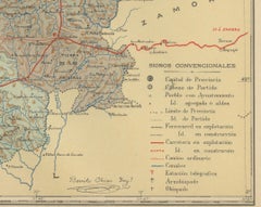
Orense in Depth: A 1902 Topographical Map of Galicia's Mountainous Province
Located in Langweer, NL
the map: Description: - The map is a colorful, topographic illustration, highlighting the varied
Paper

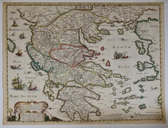
Greece, "Graeciae Antiquae"" A 17th Century Hand-colored Map by Sanson
By Nicolas Sanson
Located in Alamo, CA
. There is a large paper watermark. This attractive colorful map is presented in a cream-colored mat
Paper
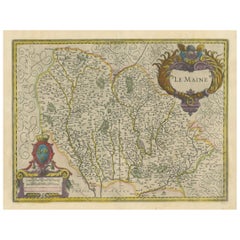
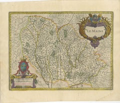
Map of Le Maine by H. Hondius, 1633, Hand-Colored, Decorative and Historic
Located in Langweer, NL
to highlight the map’s warm patina and colorful detailing. Conservation glass is advised to prevent
Paper

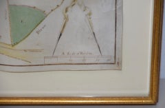
Mid-18th Century Hand Drawn English Farm Map on Vellum, circa 1740s
Located in San Francisco, CA
Mid-18th century hand drawn English farm map on Vellum circa 1740s Henry Maxted & Isaac Terry
Lambskin
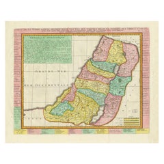
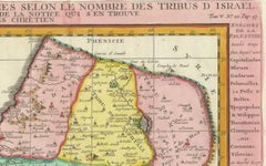
1732 Henri Chatelain Map of the Holy Land Divided Among the Tribes of Israel
Located in Langweer, NL
Title: 1732 Henri Chatelain Map of the Holy Land Divided Among the Tribes of Israel This
Paper
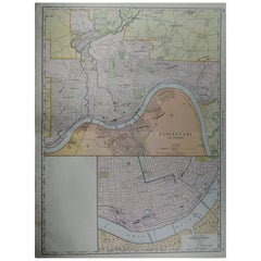
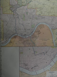
Large Original Antique City Plan of Cincinnati, USA, circa 1900
By Rand McNally & Co.
Located in St Annes, Lancashire
Fabulous colorful map of Cincinnati, Ohio. Original color By Rand, McNally & Co
Paper
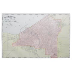
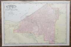
Original Antique City Plan of Cleveland, Ohio, USA, circa 1900
By Rand McNally & Co.
Located in St Annes, Lancashire
Fabulous colorful map of Cleveland Original color By Rand, McNally & Co. Published, circa 1900
Paper
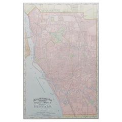

Original Antique City Plan of Buffalo, New York, USA, circa 1900
By Rand McNally & Co.
Located in St Annes, Lancashire
Fabulous colorful map of Buffalo Original color By Rand, McNally & Co. Published, circa 1900
Paper
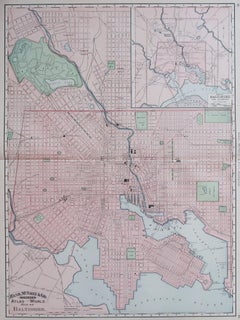
Large Original Antique City Plan of Baltimore, USA, 1894
By Rand McNally & Co.
Located in St Annes, Lancashire
Fabulous colorful map of Baltimore Original color By Rand, McNally & Co. Published, 1894
Paper
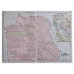
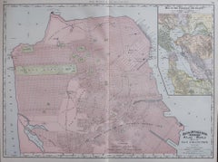
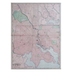
Large Original Antique City Plan of San Francisco, USA, 1894
By Rand McNally & Co.
Located in St Annes, Lancashire
Fabulous colorful map of San Francisco Original color By Rand, McNally & Co. Published
Paper

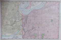
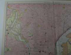
Original Antique City Plan of Kansas City, USA. 1894
By Rand McNally & Co.
Located in St Annes, Lancashire
Fabulous colorful map of Kansas City Original color By Rand, McNally & Co. Published, 1894
Paper

Large Original Antique City Plan of Philadelphia, USA, circa 1900
By Rand McNally & Co.
Located in St Annes, Lancashire
Fabulous colorful map of Philadelphia Original color By Rand, McNally & Co. Published
Paper

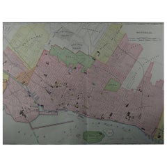
Large Original Antique City Plan of Montreal, Canada, circa 1900
By Rand McNally & Co.
Located in St Annes, Lancashire
Fabulous colorful map of Montreal Original color By Rand, McNally & Co. Published, circa 1900
Paper
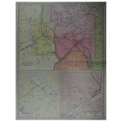
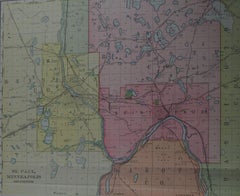
Large Original Antique City Plan of Minneapolis and St Paul, USA, circa 1900
By Rand McNally & Co.
Located in St Annes, Lancashire
Fabulous colorful map of Minneapolis and St Paul, Minnesota. Original color By Rand, McNally & Co
Paper

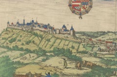
Limburg Cityscape 1580: Historical Copper Engraving by Braun and Hogenberg
Located in Langweer, NL
Limburg Verso: Contains Latin text Margins: Narrow This map is a detailed and colorful illustration of
Paper

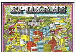
Original Spokane (WA.) Colorful Capital Fun Map vintage poster
Located in Spokane, WA
Original Spokane (Washington), The Colorful Capital of the Inland Empire vintage travel fun map
Lithograph
$700
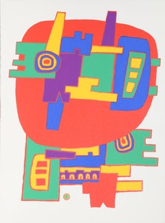
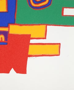
Robot Map, Red Colorful Abstract Psychedelic Screenprint by Jacques Soisson
Located in Long Island City, NY
Artist: Jacques Soisson Title: Untitled 12 Year: 1978 Medium: Screenprint, signed and numbered in pencil Edition: 150 Paper Size: 30 x 25 inches
Screen
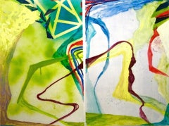
"Map Voice #9, 10" Expressionist Abstract Green Colorful Gouache Modern Bold
By Susan Sharp
Located in Wellesley, MA
"Map Voice #9, 10"" 2020, Gouache and Spray Paint on Yupo (2 Panels, Diptych). Abstraction in
Mixed Media

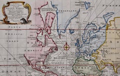
Map of the World: An Original 18th Century Hand-colored Map by E. Bowen
Located in Alamo, CA
and Travels". This highly detailed and colorful map depicts the world. as it was known in the mid 18th
Engraving

$1,275
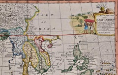
Map of the East Indies: An Original 18th Century Hand-colored Map by E. Bowen
Located in Alamo, CA
Collection of Voyages and Travels". This highly detailed and colorful map depicts the East Indies, as it was
Engraving

$675
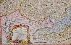
Map of the Russian Empire: An Original 18th Century Hand-colored Map by E. Bowen
Located in Alamo, CA
Voyages and Travels". This highly detailed and colorful map depicts the Russian Empire, as it was known in
Engraving

Butterfly Map II, Painting, Acrylic on Canvas
By Karin Goeppert
Located in Yardley, PA
Butterfly Map II" is a bright, colorful, lively and energetic artwork on canvas - ready to hang
Acrylic

Butterfly Map I, Painting, Acrylic on Canvas
By Karin Goeppert
Located in Yardley, PA
"Butterfly Map I" is a bright, colorful, lively and energetic artwork on canvas - ready to hang
Acrylic

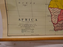
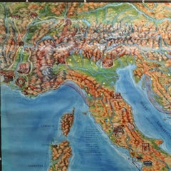
Large University Chart “Physical Map of Africa” by Bacon
Located in Godshill, Isle of Wight
Maps By G W Bacon, This is colorful Physical map of North America, it is large lithograph set on
Linen
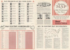
American Election Map and 1960 Presidential Fact Sheet, Published 1960
Located in Langweer, NL
: 1960 (dated) Color: Printed Color Size: 24.9 x 17.9 inches (63.2 x 45.5 cm) This colorful map of
Paper

Large University Chart “Political Map of North America” by Bacon
Located in Godshill, Isle of Wight
Political Maps by G W Bacon, This is colorful Physical map of North America, it is large lithograph set
Linen
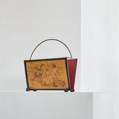
Jacques Liozu Magazine Rack with Whimsical Silk Screened Maps France 1950s
Located in Meer, VAN
stone-red inside is a very nice contrast with the colorful maps on both sides. A great modernist design
Metal

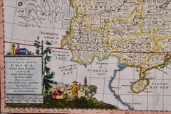
China: An Original 18th Century Hand-colored Map by E. Bowen
Located in Alamo, CA
detailed and colorful map depicts China, Korea, Taiwan (Formosa), the Yangtze and Yellow Rivers, the great
Engraving

$1,175
West Germany: Original Hand Colored 17th Century Map by Johannes Janssonius
By Johannes Janssonius
Located in Alamo, CA
colorful map with its beautiful cartouche has a central fold, as issued. There is minimal color offset in
Engraving
$1,750Sale Price|22% Off
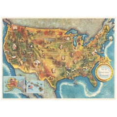
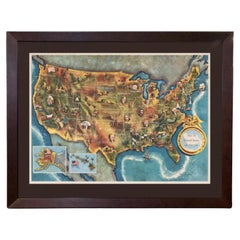
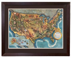
1960 "The 50 United States of America" Pictorial Map by Lorin Thompson
Located in Colorado Springs, CO
This colorful map of the United States was drawn by Lorin Thompson and published by the General
Paper

$1,275
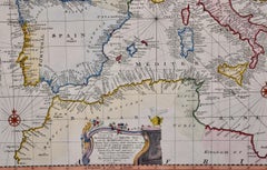
Mediterranean and Adriatic Seas: Original 18th Century Hand-colored Map by Bowen
Located in Alamo, CA
and Travels". This highly detailed and colorful map depicts the Mediterranean and Adriatic Sea's and
Engraving

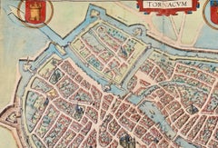
Tournai (Tournay), Belgium: A 16th Century Hand-colored Map by Braun & Hogenberg
By Franz Hogenberg
Located in Alamo, CA
in the key corresponding to their locations on the map. This colorful map of Tournai (Tornacum or
Engraving

Religious Bible Mural Journey of Apostle Paul Rollable Vintage Map Wall Chart
Located in Berghuelen, DE
A colorful picturous map showing the journey of the apostle Paul, published by Becker´s Hamburg
Canvas, Wood, Paper

$475
Siberia as Explored by Behring: Original 18th Century Hand-colored Map by Bowen
Located in Alamo, CA
Bibliotheca" or "A Complete Collection of Voyages and Travels". This highly detailed and colorful map is the
Engraving
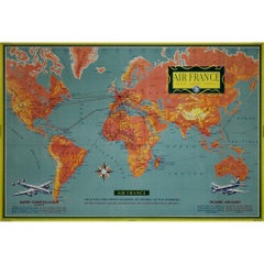
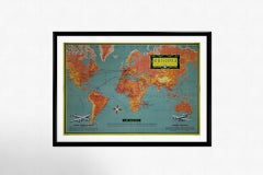
1956 original Air France poster “Réseau Aérien Mondial” (World Air Network)
Located in PARIS, FR
, showcasing Air France’s extensive international network. The map-based design features a colorful, stylized
Paper, Lithograph

$1,800
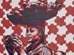
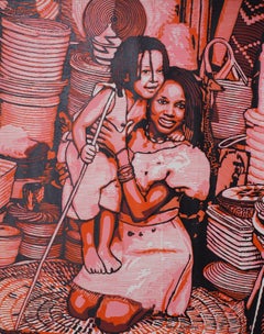
This or That (Ona Kan O Woja) - 21st Century, Contemporary Figurative, Linocut
Located in Ibadan, Oyo
perspective while facial contours are colorfully mapped out with divisive lines. This technique is a
Canvas, Linocut


$1,750
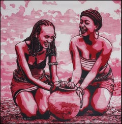
Iwoye (Perception 2) - 21st Century, Contemporary Figurative, Africa Linocut
Located in Ibadan, Oyo
perspective while facial contours are colorfully mapped out with divisive lines. This technique is a
Canvas, Linocut
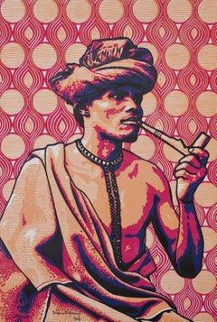
$1,750
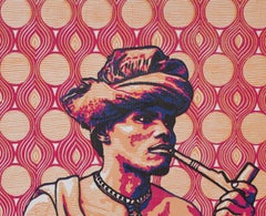
Amukoko (Enjoyment Galore -21st Century, Contemporary Figurative, Africa Linocut
Located in Ibadan, Oyo
perspective while facial contours are colorfully mapped out with divisive lines. This technique is a
Canvas, Linocut

$2,000
Dual Treasure - 21st Century, Contemporary, Figurative, Africa, Linocut, Women
Located in Ibadan, Oyo
perspective while facial contours are colorfully mapped out with divisive lines. This technique is a
Canvas, Linocut

$2,250
At Prime (Igba Ara) - 21st Century, Contemporary, Figurative, Africa, Linocut
Located in Ibadan, Oyo
perspective while facial contours are colorfully mapped out with divisive lines. This technique is a
Canvas, Linocut
$239Sale Price|20% Off
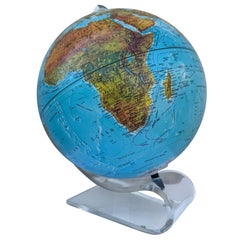
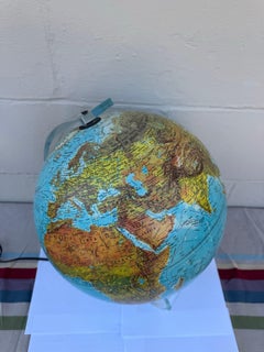
Vintage 1987 Scan-Globe Illuminated World Globe on Lucite Base, Denmark
Located in San Carlos, CA
, this stunning piece features a colorful topographical map showcasing the geopolitical landscape of the
Lucite