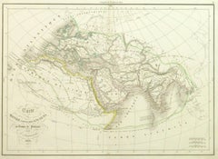
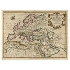
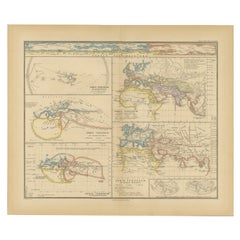
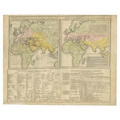
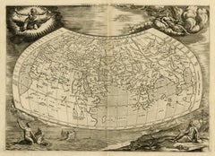
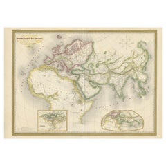
Ancient World Map
Located in Houston, TX
Over 150 year old engraved map of the world as it was known during the antiquities by cartographer
Category
1830s More Prints
Materials
Ink, Watercolor, Handmade Paper
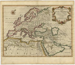
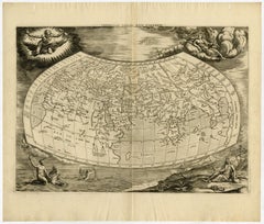
Ancient World Map
Located in Houston, TX
Over 150 year old engraved map of the world as it was known during the antiquities by cartographer
Ink, Watercolor, Handmade Paper
$1,622
H 21.42 in W 29.77 in D 0.01 in
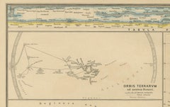
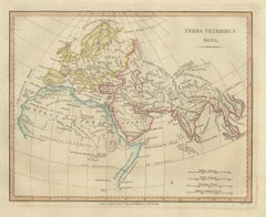
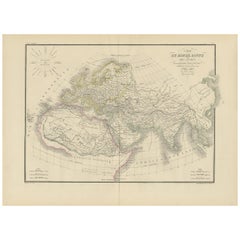
Antique Ancient World Map – Orbis Veteribus Notus, Engraving c.1818
Located in Langweer, NL
Antique Ancient World Map – Orbis Veteribus Notus, Engraving c.1818 Striking antique map depicting
Paper
$536
H 9.45 in W 14.57 in D 0 in
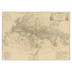
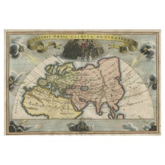
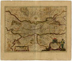
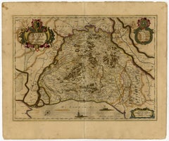
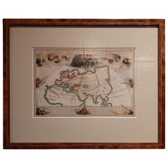
Veteris Orbis Climata – Ancient World Map after Strabo by Cellarius, 1731
Located in Langweer, NL
Veteris Orbis Climata – Ancient World Map after Strabo by Cellarius, 1731 This fascinating hand
Paper
$423Sale Price|20% Off
H 16.3 in W 22.33 in D 0.01 in
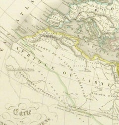
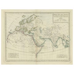
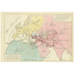
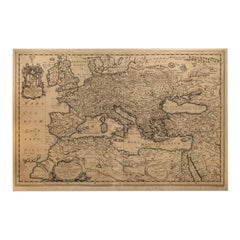
Ancient World Map: Europe, Africa & Asia - 1802 Tardieu Atlas
Located in Langweer, NL
Revolutionary Calendar) Geographical Scope: This antique map illustrates the "known world" of the ancients
Paper
$1,126Sale Price|25% Off
H 15.75 in W 18.51 in D 0.01 in
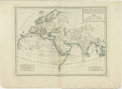
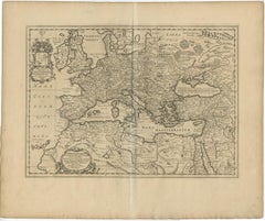
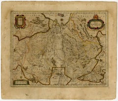
Ancient World Map of Europe, Asia & Northern Africa with Ancient Names, 1725
Located in Langweer, NL
ancient world depicting Europe, Asia, and northern Africa with ancient place names. This map originates
Paper
$583
H 9.73 in W 14.02 in D 0.01 in
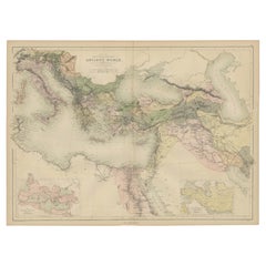
Ancient World Map, Roman Macedonian Persian Empires, Ferrario 1815
Located in Langweer, NL
Antique Map of Asia 1815 – Carta Generale dell’Asia, Ferrario, Italy This refined early 19th
Paper
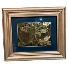
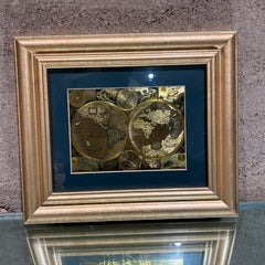
Late 20th Century Gold Foil World Map Double Hemisphere
Located in Chula Vista, CA
Late 20th Century Gold Foil Ancient World Map Double Hemisphere Gold Foil Old World Framed Map
Gold
$834
H 20.79 in W 25.04 in D 0.02 in
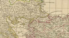
Ancient Europe Map 1652, Europa Antiqua – Nicolas Blancardus, Roman World
Located in Langweer, NL
Ancient Europe Map 1652, Europa Antiqua – Nicolas Blancardus, Roman World Description: This
Paper
$352Sale Price|20% Off
H 15.56 in W 18.51 in D 0 in
Original Old Composite of Several Maps of the Ancient World on One Sheet, 1880
Located in Langweer, NL
Theodorus Menke. The map is a detailed depiction of the ancient world. The atlas it comes from is known for
Paper
$352Sale Price|20% Off
H 15.56 in W 18.51 in D 0 in
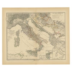
Roman Italy and Provinces: A Cartographic Snapshot, 1880
Located in Langweer, NL
designed to aid in the study of Roman history, providing a visual tool for understanding the ancient world
Paper
$312
H 11.03 in W 13.47 in D 0.01 in
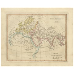
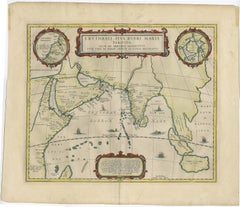
Terra Veteribus Nota — Classical World Map of Antiquity, Wilkinson 1814
Located in Langweer, NL
visible on the map): Terra Veteribus Nota, classical world map, ancient geography, Roman world, Greek
Paper
$1,442
H 28.55 in W 21.46 in D 0.01 in
Eastern Roman World Map, Black Sea & Levant, Antique Engraving c.1818
Located in Langweer, NL
world map, ancient geography, classical cartography, d’anville map, laurie and whittle, 19th century map
Paper
$1,310
H 19.49 in W 22.45 in D 0 in
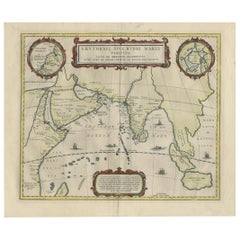
Old Map of Ancient Times covering Egypt Towards Arabia and India to Java, c.1660
Located in Langweer, NL
cities of the world"" (Townatlas), of the waterworld (Atlas Maritimus in 33 maps), and of the Ancient
Paper
$1,429
H 28.55 in W 21.46 in D 0.01 in
Antique Roman Empire Map – Western Mediterranean & Europe, Engraving c.1818
Located in Langweer, NL
reconstructions of the ancient world defined classical cartography for generations. Unlike earlier decorative maps
Paper
$629Sale Price|20% Off
H 14.57 in W 18.12 in D 0 in
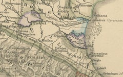
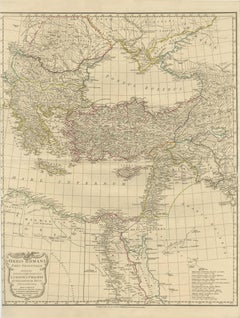
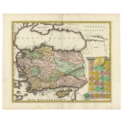
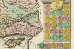
Decorative Antique Map of Cyprus and Asia Minor by Christoph Weigel, Circa 1720
Located in Langweer, NL
cartographer map - Rare map of ancient world - 18th-century German maps - Collectible map of Asia Minor
Paper

$417
H 13.86 in W 17.13 in D 0.01 in
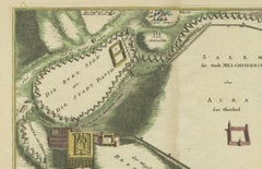
1720 Weigel Engraving of Jerusalem: A Biblical View from Josephus' Perspective
Located in Langweer, NL
of the ancient world. Central to the map are the cities of Melchizedek and David, surrounded by
Paper

$1,502
H 18.71 in W 22.64 in D 0 in
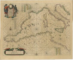
Original Antique Engraving of a Sea Chart of the Western Mediterranean, ca.1650
Located in Langweer, NL
), and of the Ancient World (60 maps). The eleventh volume was the Atlas of the Heavens by Andreas
Paper
Maps of the Ancient World and the Posterity of Noah, 1820
Located in Langweer, NL
Two maps on one sheet. Hhand colored engraved lithograph, depicting the world as known to the
Paper
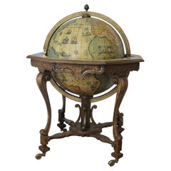
Vintage globe bar, 1950s
Located in Leuven, Vlaams Gewest
Vintage globe bar on wheels with an old world map and ancient drawings troughout. Brass casters
Brass
Unavailable
H 17.72 in W 20.48 in
Very decorative world map of the ancient world by Mercator - Engraving - 17th c.
By Gerard Mercator
Located in Zeeland, Noord-Brabant
of the ancient world. Surrounded by allegorical figures representing the four elements: Fire (Zeus
Engraving
Unavailable
H 19.61 in W 23.23 in
Ducatus Gelriae pars prima quae est Neomagensis.
By Johannes Janssonius
Located in Zeeland, Noord-Brabant
in 33 maps), and of the Ancient World (60 maps). The eleventh volume was the Atlas of the Heavens by
Engraving, Etching
Trasisalania vulgo Overyssel.
Located in Zeeland, Noord-Brabant
cities of the world" (Townatlas), of the waterworld (Atlas Maritimus in 33 maps), and of the Ancient
Engraving, Etching
Unavailable
H 19.61 in W 23.35 in
Ducatus Gelriae pars quarta quae est Arnhemiensis, sive Velavia.
By Johannes Janssonius
Located in Zeeland, Noord-Brabant
" (Townatlas), of the waterworld (Atlas Maritimus in 33 maps), and of the Ancient World (60 maps). The eleventh
Engraving, Etching
![Tabula Castelli ad Sandflitam, qua simul inundati agri, alluviones, [...].](https://a.1stdibscdn.com/archivesE/upload/a_5923/1509441013669/cb3408_master.jpg?width=240)
Unavailable
H 19.53 in W 23.31 in
Tabula Castelli ad Sandflitam, qua simul inundati agri, alluviones, [...].
By Johannes Janssonius
Located in Zeeland, Noord-Brabant
in 33 maps), and of the Ancient World (60 maps). The eleventh volume was the Atlas of the Heavens by
Engraving, Etching
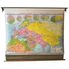
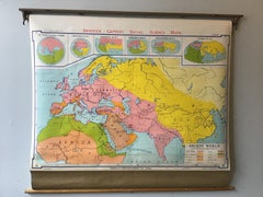
1968 Ancient World School Map
Located in Tarrytown, NY
Pull down school map of the ancient world made, in Chicago in the 1960s.
Paper
Sold
H 37.41 in Dm 27.56 in
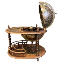
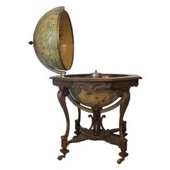
1960s Large Italian World Map Globe Bar Cart or Drinks Trolley with Zodiac Signs
Located in London, England
ancient world map with different colours for each country. The sphere world globe rotates around its
Walnut

Sold
H 25.25 in W 30.25 in D 2 in
Rare 17th Century American Map of Virginia and Florida by Jan Janssonius
By Jan Johansson
Located in Wiscasset, ME
cities of the world" (Townatlas), of the waterworld (Atlas Maritimus in 33 maps), and of the Ancient

Sold
H 17.92 in W 22.52 in D 0 in
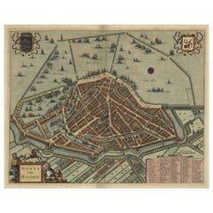
Original Antique Bird's Eye View Plan of Hoorn, The Netherlands by Blaeu, c.1700
Located in Langweer, NL
waterworld (Atlas Maritimus in 33 maps), and of the Ancient World (60 maps). The eleventh volume was the
Paper
Very Large Antique Brass and Mahogany Atlas Coffee Table
Located in London, GB
edge which holds in a glass top over an ancient map of the world. The map is typical of the way the
Brass

Antique Map of the Ancient World 'c.1860'
Located in Langweer, NL
Antique map titled 'Monde connu des Anciens'. Large, original antique map of the Ancient World
Paper

Antique Map of the Ancient World by Lapie, 1842
Located in Langweer, NL
Antique map titled 'Carte du Monde Connu des Anciens'. Map of the Ancient World. This map
Paper

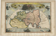
Antique Map of the Ancient World by Cellarius, 1703
Located in Langweer, NL
Antique map titled 'Veteris Orbis Climata ex Strabone'. Interesting map of the ancient world
Paper

Antique Map of the Ancient World by A & C. Black, 1870
Located in Langweer, NL
Antique map titled 'Map of the Principal Countries of the Ancient World'. Original antique map of
Paper