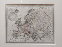
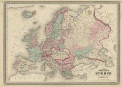
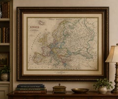
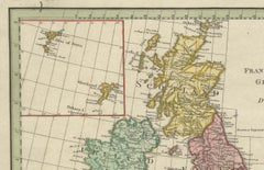
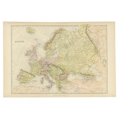
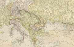
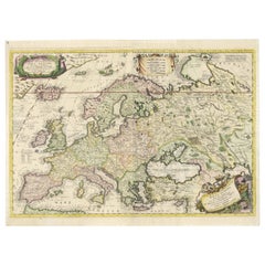
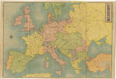
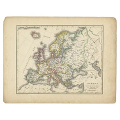
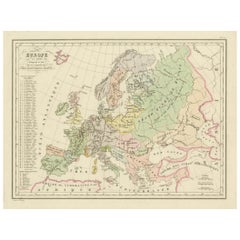
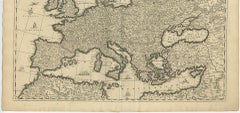
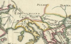
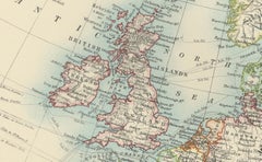
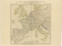
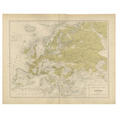
Antique Map of Europe by Lapie, '1809'
Located in Langweer, NL
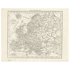
Antique map titled 'Europe'. Original antique map of Europe by P.
Category
Antique Early 19th Century Maps
Materials
Paper
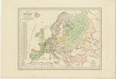
Antique Map of Europe by Lapie, '1809'
Located in Langweer, NL
Antique map titled 'Europe'. Original antique map of Europe by P.
Paper


$186Sale Price|20% Off
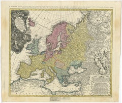
Antique Rain Map of Europe by Johnston '1850'
Located in Langweer, NL
Antique map titled 'Hyetographic or Rain Map of Europe'.
Paper

$140Sale Price|20% Off
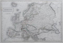
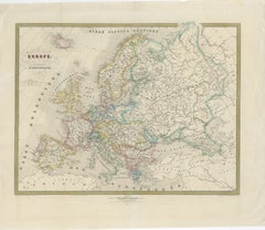
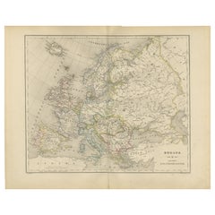
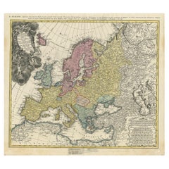
Antique Map of Europe by Balbi '1847'
Located in Langweer, NL
Antique map titled 'Europe'. Original antique map of Europe.
Paper

$28Sale Price|20% Off
Original Antique Map of Europe, Arrowsmith, 1820
Located in St Annes, Lancashire
Great map of Europe Drawn under the direction of Arrowsmith.
Paper

$327Sale Price|20% Off
Antique Map of Europe by Johnson, '1872'
Located in Langweer, NL
Antique map titled 'Johnson's Europe'. Original map of Europe.
Paper

$350Sale Price|40% Off
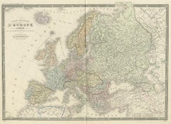
Antique Map of Europe by Levasseur, '1875'
Located in Langweer, NL
Antique map titled 'Carte générale de l'Europe'. Large map of Europe.
Paper


$140Sale Price|20% Off
Antique Map of Europe by Lowry, 1852
Located in Langweer, NL
Antique map titled 'Europe'. Original map of Europe. This map originates from 'Lowry's Table Atlas constructed and engraved from the most recent authorities' by J.W.
Paper


$140Sale Price|20% Off
Antique Map of Europe by Wyld '1845'
Located in Langweer, NL
Antique map titled 'Europe'. Original antique map of Europe.
Paper
Antique Map of Europe by Levasseur 'c.1840'
Located in Langweer, NL
Antique map titled 'Europe'. Original antique map of Europe.
Paper


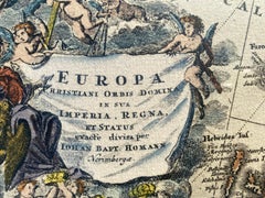
Antique Map of Europe by Hederichs, circa 1740
Located in Langweer, NL
Antique map titled 'Europa Christiani Orbis Domina'. Rare miniature map of Europe.
Paper


$147Sale Price|30% Off
Antique Map of Europe by R. Bonne, 1780
Located in Langweer, NL
A fine example of Rigobert Bonne and Guilleme Raynal’s 1780 map of Europe. Drawn by R. Bonne for G. Raynal’s Atlas de Toutes les Parties Connues du Globe Terrestre, Dressé pour l'His...
Paper


$233Sale Price|20% Off
Antique Map of Europe by W. G. Blackie, 1859
Located in Langweer, NL
Antique map titled 'Europe'. Original antique map of Europe.
Paper


$373Sale Price|20% Off
Antique Map of Europe by Keizer & de Lat, 1788
Located in Langweer, NL
Antique map titled 'Kaartje van Europa (..)'. Uncommon original antique map of Europe.
Paper
$2,044Sale Price|30% Off
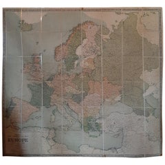
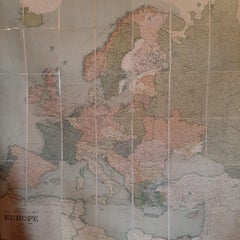
Large Wall Map of Europe by George Philip & Son, circa 1920
Located in Langweer, NL
Antique map titled 'Philips' New Commercial Map of Europe'.
Paper, Linen

$40Sale Price|20% Off
Large Original Antique Map of Europe by Sidney Hall, 1847
Located in St Annes, Lancashire
Great map of Europe Drawn and engraved by Sidney Hall Steel engraving Original colour outline Published by A & C Black. 1847 Unframed Free shipping.
Paper

Map of Europe, 1844
Located in Houston, TX
Over 150 year old engraved map of Europe by Olney from 1844. Original hand color.
Ink, Watercolor, Handmade Paper


$985Sale Price|20% Off
Vintage Reproduction 17th Century Map of Europe, American, Cartography, Blaeuw
Located in Hele, Devon, GB
This is a vintage reproduction map of Europe. An American, paper stock cartography print in frame after the work by Blaeuw, dating to the late 20th century, circa 1970.
Glass, Wood, Paper

$430Sale Price|20% Off
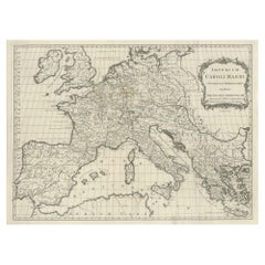
Antique Map of Europe by T. Kitchin, Charlemagne's Empire, Circa 1779
Located in Langweer, NL
Antique map titled 'Imperium Caroli Magni (..)'. Large antique map of Europe, showing the Empire of Charlemagne in the 8th Century.
Paper

1849 Map of "Europaische Russland", 'Meyer Map of European Russia', Ric. R017
Located in Norton, MA
1849 Map of "Europaische Russland" ( Meyer Map of European Russia) Ric.r017 A lovely map of European Russia dating to 1849 by Joseph Meyer.
Paper


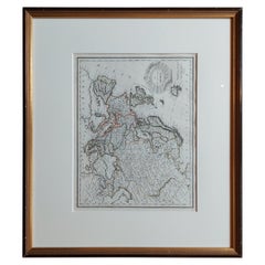
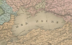
Antique Map of Europe by Pierre M. Lapie, Engraved, France, 1842
Located in Langweer, NL
Antique map titled 'Carte de l'Europe'. Map of Europe. This map originates from 'Atlas universel de géographie ancienne et moderne (..)' by Pierre M.
Paper

Nice Decorative Black and White Small Antique Map of Europe, 'circa 1834'
Located in Langweer, NL
Antique French map titled 'Europe par A.H. Dufour'. Uncommon map of Europe.
Paper
French Map of Europe by Cortambert – Russia, Scandinavia & Balkans, 1864
Located in Langweer, NL
French Map of Europe by Cortambert – Russia, Scandinavia & Balkans 1864 A large and finely detailed antique map of Europe published in Paris in 1864 under the direction of the Frenc...
Paper
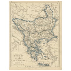
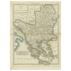
1852 Antique Map of European Turkey and Greece by J.W. Lowry
Located in Langweer, NL
Antique map titled 'European Turkey and Greece with the Ionian Islands'.
Paper
$850Sale Price|35% Off
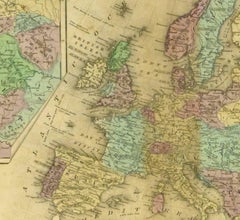
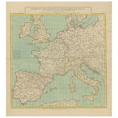
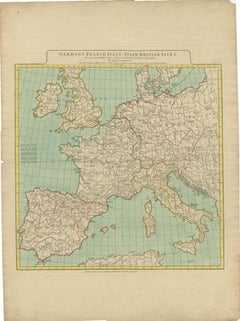
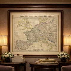
1788 Map of Europe - France, Italy, Spain, Germany, Great Britain & Ireland
Located in Langweer, NL
Title: "1788 Map of Europe - France, Italy, Spain, Germany, Great Britain & Ireland by D'Anville" Description: This detailed map of Europe, titled "First Part of the Map of Eu...
Paper
$177Sale Price|20% Off
Colorful Detailed Antique Map of Europe, Published in 1882
Located in Langweer, NL
"The Antique Map of Europe from 'The Comprehensive Atlas and Geography of the World,' published in 1882 by Blackie & Son, is a testament to meticulous cartography and scholarly preci...
Paper

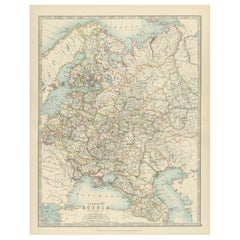
Antique Map of European Russia by Tirion, c.1725
Located in Langweer, NL
Detailed map of European Russia. Artists and Engravers: Isaak Tirion, a Dutch publisher in Amsterdam, was born 1705.
Paper
$2,711Sale Price|20% Off
17th-Century Coronelli Map of Europe, Engraved Detail, Venice 1692
Located in Langweer, NL
Large 17th-Century Coronelli Map of Europe with Mythical Islands and Rich Detail This exceptional two-sheet map of Europe by Vincenzo Maria Coronelli, published in Venice in 1692,...
Paper
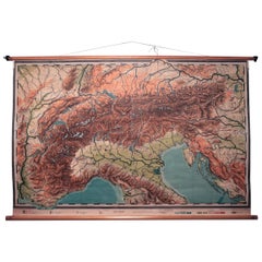

Vintage Swedish Topographic School Map of European Alps, Made in Sweden 1922
Located in Los Angeles, CA
Vintage Swedish Topographic School map of European Alps, Made in Sweden 1922 This vintage Swedish school map is so unique and a great example of why these are so collectible.
Linen, Wood, Paper
Antique Japanese Map of Europe, Russo-Japanese War, Meiji 1904
Located in Langweer, NL
Antique Japanese Map of Europe, Russo-Japanese War, Meiji 1904 This striking and historically charged Japanese map of Europe was issued in 1904 (Meiji 37) at the outbreak of the Rus...
Paper
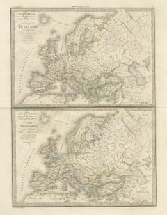
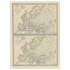
Antique Double Map of Europe, Barbarian Invasions – Lapie, Paris, 1838
Located in Langweer, NL
Antique Double Map of Europe, Barbarian Invasions – Lapie, Paris, 1838 This striking double-sheet map of Europe was published in Paris in 1838 as part of the Atlas Universel de Géog...
Paper
Antique Map of Europe – Political Divisions by Andriveau-Goujon, Paris 1861
Located in Langweer, NL
Antique Map of Europe – Political Divisions by Andriveau-Goujon, Paris 1861 This beautifully engraved and hand-colored antique map of Europe was published in 1861 by the Parisian ca...
Paper

Antique Map of Europe from an Old Dutch School-Atlas, 1852
Located in Langweer, NL
Antique map titled 'Europa'. Map of Europe. This map originates from 'School-Atlas van alle deelen der Aarde' by Otto Petri.
Paper

Two Antique Maps of Europe on One Sheet in Different Time Periods, 1842
Located in Langweer, NL
Antique map titled 'Carte de l'Europe'. Two maps of Europe.
Paper

Political Map of Europe – Nieuwe Hand-Atlas by Frijlink & van Otterloo, 1876
Located in Langweer, NL
Title: Political Map of Europe – Nieuwe Hand-Atlas by Frijlink & van Otterloo, 1876 Description: This 19th-century Dutch map titled “Europa” was published in 1876 in the Nieuwe Hand...
Paper
$1,382Sale Price|30% Off
Map of Europe Highlighting Ancient and Modern Geographical Divisions (1794)
Located in Langweer, NL
Map of Europe Highlighting Ancient and Modern Geographical Divisions (1794).
Paper
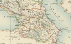
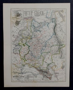
Antique Map of European Russia, 1903, with Colorful Provincial Boundaries
Located in Langweer, NL
Title: Antique Map of European Russia, 1903, with Colorful Provincial Boundaries Description: This antique map, titled "European Russia," was engraved and published in 1903 by W. & ...
Paper
Antique Map of Europe in the 12th Century - Malte-Brun & Sarrazin, 1880
Located in Langweer, NL
Title: Antique Map of Europe in the 12th Century - Malte-Brun & Sarrazin, 1880 Description: This is an antique map titled "Europe en 1100," depicting Europe as it was around the 12...
Paper
Map of Europe
Located in Roma, IT
Etching hand colored realized by Giovanni Maria Cassini in 1788. Table from "Nuovo Atlante Geografico Universale", published in Rome in 1788 at Calcografia Camerale. Very good cond...
Etching
Grand Map of Europe by Frederick de Wit, Circa 1690: A Baroque Era Masterpiece.
Located in Langweer, NL
This is an attractive historical map of Europe created by Frederick de Wit, published around 1690.
Paper
Antique Map of Europe with Elaborate Title Cartouche, c.1750
Located in Langweer, NL
Ordin des Mathematiques: Publiee par les Heritiers d'Homann L'An 1743'. This map depicts all of Europe including Iceland and parts of North Africa and Asia.
Paper
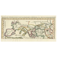
Phoenician Trade Routes – Antique Map of Europe and the Mediterranean, 1748
Located in Langweer, NL
Phoenician Trade Routes – Antique Map of Europe and the Mediterranean, 1748 This antique German map titled Vorstellung von Europa zur Erläuterung der Schifffahrt der Phönicier auf d...
Paper


Antique Map of Europe Stretching from Northern Africa to the Baltic Sea, 1719
Located in Langweer, NL
Original antique map of Europe stretching from northern Africa to the Baltic Sea.
Paper

Majestic Map of Europe by Andriveau-Goujon - Complete Continental View - ca.1849
Located in Langweer, NL
Majestic 19th Century Map of Europe by Andriveau-Goujon - Complete Continental View - Circa 1849 This magnificent and intricately detailed map of Europe, titled "Carte Physique et...
Paper
Antique Map of Europe in the Year 800 and 1500, Published in 1842
Located in Langweer, NL
Antique map titled 'Carte de l'Europe'. Two maps of Europe.
Paper

Antique Map of Europe, 1903, with Intricate Political Boundaries and Rich Detail
Located in Langweer, NL
Title: Antique Map of Europe, 1903, with Intricate Political Boundaries and Rich Detail Description: This antique map, titled "Europe," is a finely engraved and beautifully colored ...
Paper
$355Sale Price|20% Off
Antique Map of European Russia with Picture Frame Border
Located in Langweer, NL
Antique map titled 'La Moscovie Septentrionale (..)'. Decorative example of van der Aa's map of the northern part of European Russia.
Paper

$1,700Sale Price|33% Off
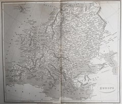
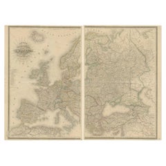
Two-Part Large Hand-Colored Map of Europe from 1798
By Thomas Kitchin
Located in New York, NY
Map of Europe printed on two separate sheets from A New Universal Atlas by Thomas Kitchin.
Paper
Antique Map of Europe – Roman to Medieval Transition, d’Anville, c.1818
Located in Langweer, NL
Particularly effective when grouped with Roman and early medieval European maps. Technique: Engraving with original outline color Maker: Jean-Baptiste Bourguignon d’Anville (after),...
Paper

Vintage Map of Europe Italian Framed Print in Freijo Wood with Brass Rosettes
Located in Miami, FL
Vintage Map of Europe Italian Framed Print in Freijo Wood with Brass Rosettes Offered for sale is a vintage map of Europe beautifully framed under glass in Brazilian freijo wood ado...
Glass, Wood, Paper

$317Sale Price|20% Off
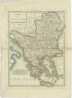
Antique Map of European Turkey and Greece, Copperplate Engraving, 1857
Located in Langweer, NL
European Turkey and Greece Map – Balkans and Ionian Islands 1857 This detailed antique print shows “Die Europäische Türkei, Griechenland und die Ionischen Inseln” meaning “European ...
Paper

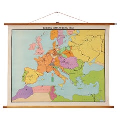
Vintage school wall map of Europe 1815-1871, Belgium 1950s
Located in Meulebeke, BE
Belgium / 1950 / school map Europe 1815-1871 / canvas, wood / Mid-century / vintage Vintage school map of Europe between 1815 and 1871, designed by C.J.P.
Canvas, Wood
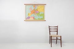
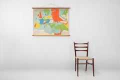
Vintage historical wall map of Europe around 1812, Belgium 1950s
Located in Meulebeke, BE
Belgium / 1950 / school map Europe 1812 / canvas, wood / Mid-century / vintage Beautiful vintage wall-mounted historical map of Europe around 1812, designed by Inst.
Canvas, Wood
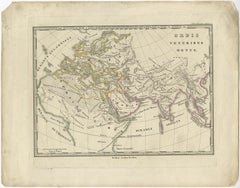
Antique Map of Europe and Part of Asia and Africa, 1848
Located in Langweer, NL
Antique map titled 'Orbis Veteribus Notus'. Old map of the European continent, also depicting a portion of Asia and Africa.
Paper
Genuine Antique Map of European Turkey by Pierre Antoine Tardieu, 1802
Located in Langweer, NL
This is an original antique map titled "Carte de la Turquie d'Europe," which depicts the European territories of the Ottoman Empire.
Paper
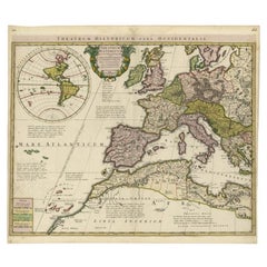
Finely Engraved Antique Map of Europe with inset of America, c.1745
By Guillaume De L'Isle
Located in Langweer, NL
Finely engraved historical map with a profusion of details. It shows western Europe and the northern Mediterranean basin as far as Crete.
Paper
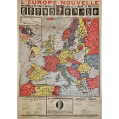
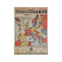
Original poster, titled “L’Europe Nouvelle” - political map of Europe
Located in PARIS, FR
This fascinating original poster, titled “L’Europe Nouvelle”, presents a vivid political map of Europe and the world as reshaped by the Treaty of Versailles, signed in 1919 at the co...
Linen, Paper, Lithograph

Physical Map of Europe – Nieuwe Hand-Atlas by Frijlink & van Otterloo, 1876
Located in Langweer, NL
The map uses fine lithographic lines with delicate hand-coloring to outline political boundaries—yellow for the Americas, pink for Asia, and blue for Europe.
Paper
It's hard to resist the allure of a beautiful pool. So, go ahead and daydream about whiling away your summer in paradise.
It’s never too early for good design. These interiors combine elevated furnishings and a youthful spirit, resulting in spaces that are at once elegant and whimsical.
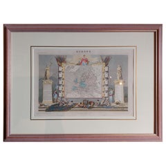
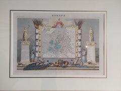
Produced in 1843, the well-preserved volume is evidence of the author's exacting specifications.
New or old, the coverlets add old-time charm to any space.
Get into the games! These items celebrate the events, athletes, host countries and sporting spirit.
French trendsetter and serial collector Daniel Rozensztroch tells us about his obsession with objects related to seafaring men.
The sought-after designer worked with the team at Hoffman Creative to produce a monograph that beautifully showcases some of Studio Shamshiri's most inspiring projects.
Italian writer and collector Umberto Pasti opens the doors to his remarkable cave of wonders in North Africa.