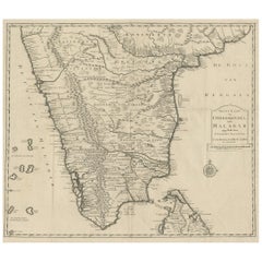
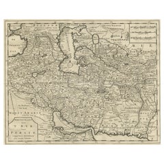
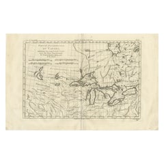
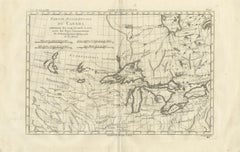
Great Lakes Antique Map — Canada, Midwest USA, Enlightenment Era, Bonne c.1780
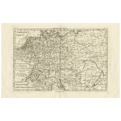
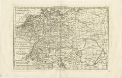
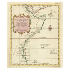
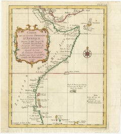
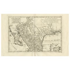
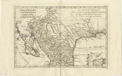
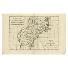
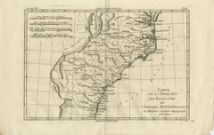
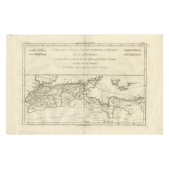
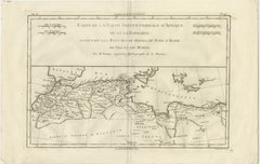
This finely engraved eighteenth-century map by Rigobert Bonne presents a detailed depiction of the western part of Canada centered on the Great Lakes region, including Lakes Superior, Michigan, Huron, Erie, and Ontario together with surrounding territories and indigenous lands. Engraved circa 1780, the map reflects Bonne’s influential position as Ingénieur-Hydrographe de la Marine and chief cartographer at the Dépôt de la Marine in Paris, where he succeeded Jacques-Nicolas Bellin and helped define Enlightenment-era cartography through scientific precision, clarity of layout, and systematic geographic representation.
Titled “Partie Occidentale du Canada, contenant les cinq Grands Lacs avec les Pays Circonvoisins,” the map illustrates the strategic and geographic importance of the Great Lakes basin during the late eighteenth century. The interconnected lake system is rendered with remarkable clarity, showing major waterways, portages, settlements, and indigenous territories. Numerous tribal and regional names appear across the landscape, reflecting contemporary European knowledge derived from exploration, trade networks, and colonial mapping efforts. River systems connecting the interior to the St. Lawrence basin and Mississippi watershed are carefully delineated, underscoring the importance of these routes for fur trade commerce, military movement, and geographic exploration.
Bonne’s restrained engraving style is evident throughout. Delicate linework and subtle hachuring convey relief without excessive ornamentation, while grid lines and structured typography emphasize scientific readability. The wide horizontal composition allows viewers to grasp the vast geographic relationships between the Great Lakes, inland territories, and surrounding regions. Produced during a period of shifting colonial control following the Seven Years’ War, the map offers valuable insight into European understanding of North American geography during a transformative historical era.
Highly sought after for both historical and decorative qualities, Bonne’s maps combine scholarly credibility with elegant visual balance. This example appeals equally to collectors of early North American cartography and to interior designers seeking refined historical wall pieces with strong geographic presence.
Condition report: Good antique condition with age-related toning, visible central fold as issued, light scattered spotting, and minor handling wear consistent with eighteenth-century paper; margins remain adequate for framing.
Framing tips: Particularly effective in a dark walnut or black frame with an ivory or warm off-white mat; the panoramic horizontal format makes it ideal for placement above desks, consoles, or as part of a coordinated gallery wall featuring related North American or exploration maps.
Technique: Copperplate engraving
Maker: Rigobert Bonne, France, circa 1780
Keyword block: Great Lakes antique map, Rigobert Bonne map, Canada antique map, Lake Superior Lake Michigan map, Lake Huron Erie Ontario map, Enlightenment cartography North America, French hydrographic chart Canada, Dépôt de la Marine map, 18th century Great Lakes engraving, early Midwest USA map, indigenous territories map antique, fur trade routes map, historical Canada USA borderlands map, antique French cartography, North American exploration map, Bonne engraving map, colonial North America cartography, antique navigation...
Category
Late 18th Century French Antique Engraved Furniture