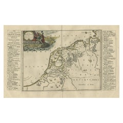
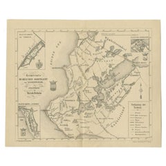
Antique Map of Friesland During Its Widest Spread, 1718
Located in Langweer, NL
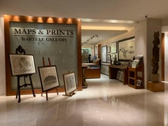
We offer a wide range of authentic antique maps for any budget.
Category
18th Century Authentic Antique Maps
Materials
Paper
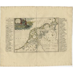
Antique Map of Friesland During Its Widest Spread, 1718
Located in Langweer, NL
We offer a wide range of authentic antique maps for any budget.
Paper
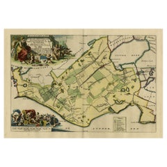
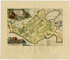
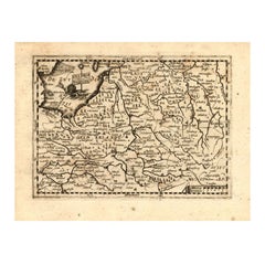
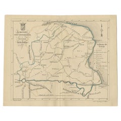
Antique Map of Gaasterland in Friesland, the Netherlands, 1718
Located in Langweer, NL
We offer a wide range of authentic antique maps for any budget.
Paper
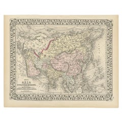

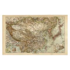
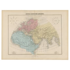
Antique Map of Asia Showing Its Political Divisions, 1874
Located in Langweer, NL
We offer a wide range of authentic antique maps for any budget.
Paper
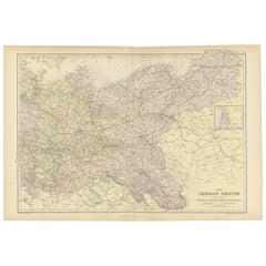
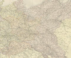
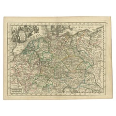
Antique Map of The German Empire (East Sheet), 1882
Located in Langweer, NL
Step into history with an authentic Antique Map of The German Empire (East Sheet) from the esteemed 'Comprehensive Atlas and Geography of the World,' meticulously crafted in 1882.
Paper


Antique Map of the Maine Region by Janssonius, 1657
By Johannes Janssonius
Located in Langweer, NL
We offer a wide range of authentic antique maps for any budget.
Paper


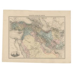
Antique Map of the Middle East by Mortier, 1700
Located in Langweer, NL
We offer a wide range of authentic antique maps for any budget.
Paper

$120Sale Price|53% Off
H 10.63 in W 8.47 in D 0 in
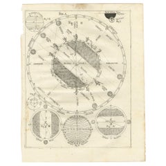
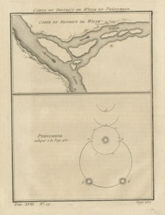
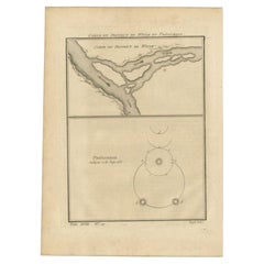
Antique Map Illustrating Solar Eclipses by Scherer, C.1703
Located in Langweer, NL
We offer a wide range of authentic antique maps for any budget.
Paper
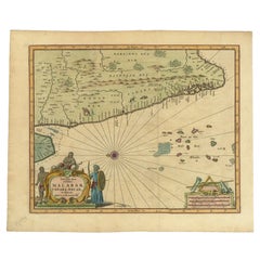

Antique Map of the Malabar Coast by Baldaeus, 1744
By Philip Baldaeus
Located in Langweer, NL
We offer a wide range of authentic antique maps for any budget.
Paper
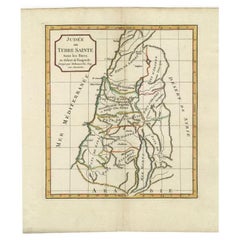

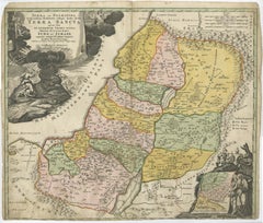
Antique Map of the Holy Land by Delamarche, 1806
By Charles Francois Delamarche
Located in Langweer, NL
We offer a wide range of authentic antique maps for any budget
Paper

Antique Map of South America Depicting Guayana, c.1780
Located in Langweer, NL
We offer a wide range of authentic antique maps for any budget.
Paper


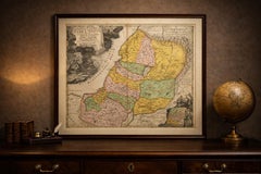
Antique Map of the Holy Land by Schut, 1710
Located in Langweer, NL
We offer a wide range of authentic antique maps for any budget
Paper


Antique Map of the Pacific Ocean by Anson, 1765
Located in Langweer, NL
We offer a wide range of authentic antique maps for any budget.
Paper


Antique Map of Friesland by De Wit, c.1690
Located in Langweer, NL
We offer a wide range of authentic antique maps for any budget.
Paper
$234
H 13.39 in W 9.45 in D 0 in
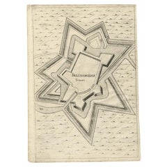
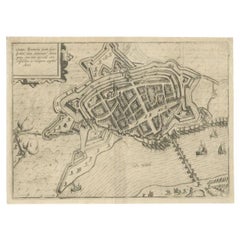
Antique Map of Fortification of Bellingwolderschans, The Netherlands, 1673
Located in Langweer, NL
We offer a wide range of authentic antique maps for any budget.
Paper

$79Sale Price|20% Off
H 9.8 in W 12.4 in D 0.001 in
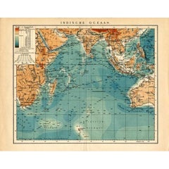
German Antique Map of the Indian Oceaan, Meyers, 1895
Located in Langweer, NL
We offer a wide range of authentic antique maps for any budget.
Paper
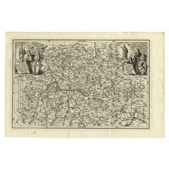

Antique Map of the Franconia Region by Scherer, 1699
Located in Langweer, NL
We offer a wide range of authentic antique maps for any budget.
Paper

Antique Map of China and Japan by Meyer, 1895
Located in Langweer, NL
We offer a wide range of authentic antique maps for any budget.
Paper
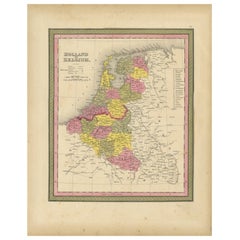

Antique Nicely Colored Map of Holland and Belgium, 1846
Located in Langweer, NL
We offer a wide range of authentic antique maps for any budget.
Paper
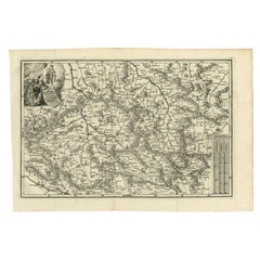

Antique Uncommon Map of Bohemia, Moravia and Silesia, 1699
Located in Langweer, NL
We offer a wide range of authentic antique maps for any budget.
Paper


Antique Map of East Frisia by Ortelius, c.1595
Located in Langweer, NL
We offer a wide range of authentic antique maps for any budget.
Paper


Antique Map of Banten Bay, Java, Indonesia, c.1725
Located in Langweer, NL
We offer a wide range of authentic antique maps for any budget.
Paper

$299Sale Price|20% Off
H 8.51 in W 11.42 in D 0 in
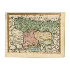
Antique Map of Barbary and Biledulgerid by Sanson, 1705
Located in Langweer, NL
Our collection includes a wide range of authentic antique maps from the 16th to the 20th centuries.
Paper

$824Sale Price|20% Off
H 20.67 in W 24.81 in D 0.02 in
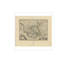
Antique Map of Greece by J. Jansson, circa 1653
Located in Langweer, NL
This is an authentic antique map of the Greece by Jan Jansson.
Paper
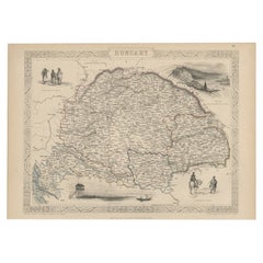
Old Engraved Map of Hungary with Decorative Vignettes, 1851
Located in Langweer, NL
We offer a wide range of authentic antique maps for any budget.
Paper
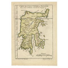

Antique Map of Celebes 'Sulawesi', Island in Indonesia, 1754
By Jacques-Nicolas Bellin
Located in Langweer, NL
We offer a wide range of authentic antique maps for any budget.
Paper

$515
H 5.91 in W 7.72 in D 0.01 in
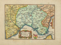
Antique Map of Andalusia Spain – Hand-Coloured Tassin Engraving 1651
Located in Langweer, NL
This is a rare opportunity to acquire an authentic 17th-century map by Nicolas Tassin, an elegant addition to any serious map collection or classic European-themed interior.
Paper

$262Sale Price|20% Off
H 6.89 in W 9.26 in D 0 in
Antique Map of Gelderland and Overijssel by Guicciardini, 1613
Located in Langweer, NL
Our collection includes a wide range of authentic antique maps from the 16th to the 20th centuries.
Paper
$398
H 19.49 in W 22.84 in D 0.01 in
Holy Land Map Judaea Palestina, Homann Engraving, Hand Colored c.1710
Located in Langweer, NL
Holy Land Map Judaea Palestina, Homann Hand Colored, c.1710 Authentic early 18th c. decorative map with restorations.
Paper


Antique Map of the City of Kampen by Guicciardini, 1613
Located in Langweer, NL
We offer a wide range of authentic antique maps for any budget
Paper

$131Sale Price|20% Off
H 9.65 in W 8.63 in D 0 in
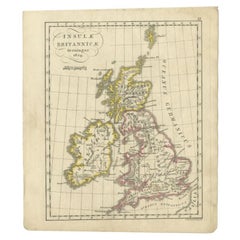
Antique Map of the United Kingdom and Ireland, circa 1825
Located in Langweer, NL
We offer a wide range of authentic antique maps for any budget.
Paper


Antique Map of Turkey and Greece by Petri, c.1873
Located in Langweer, NL
We offer a wide range of authentic antique maps for any budget.
Paper
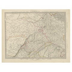

Antique Map of the Region of Delhi in India, 1833
Located in Langweer, NL
We offer a wide range of authentic antique maps for any budget.
Paper

$318Sale Price|20% Off
H 7.88 in W 11.03 in D 0 in
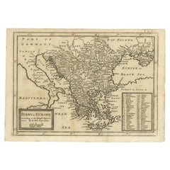
Detailed Original Antique Map of Turkey in Europe, circa 1740
Located in Langweer, NL
We offer a wide range of authentic antique maps for any budget.
Paper
$374
H 8 in W 6.42 in D 0.01 in
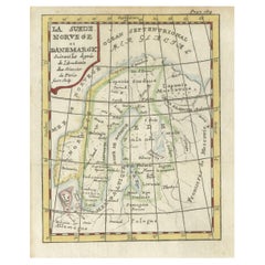
La Suede, Norvege et Danemarck – Decorative Antique Scandinavian Map, ca.1750
Located in Langweer, NL
The pleasing age patina contributes to the map’s authentic antique presence. Original fold lines, as issued, remain visible and serve as evidence of its historical format.
Paper
$262Sale Price|20% Off
H 9.85 in W 7.09 in D 0 in
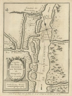
Antique Map of the Yenisei River in Siberia, Russia, 1768
By Prevost
Located in Langweer, NL
We offer a wide range of authentic antique maps for any budget.
Paper

$224Sale Price|20% Off
H 13.59 in W 18.71 in D 0 in
Antique World Map before the Voyages of Christopher Columbus, 1880
Located in Langweer, NL
We offer a wide range of authentic antique maps for any budget.
Paper


$444
H 19.89 in W 26.78 in D 0.01 in
Antique Map by Pierre M. Lapie, Turkey, Persia, Afghanistan, 1842
By Pierre M. Lapie
Located in Langweer, NL
We offer a wide range of authentic antique maps for any budget.
Paper

Antique Map of Zaltbommel in the Netherlands, by Guicciardini, 1613
Located in Langweer, NL
We offer a wide range of authentic antique maps for any budget.
Paper

$444
H 10.24 in W 16.15 in D 0.01 in
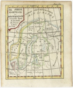
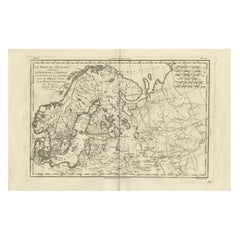
Northern Europe & Arctic Regions – Rigobert Bonne’s Map of Scandinavia, c.1780
Located in Langweer, NL
This example offers both historical depth and strong visual balance, making it equally attractive as a scholarly object and as a decorative wall map. It is especially appealing to c...
Paper
$117Sale Price|58% Off
H 9.85 in W 7.09 in D 0 in
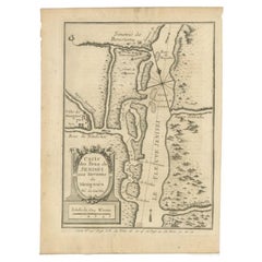
Antique Map of the Vitim and Lena Rivers, Russia, 1768
By Prevost
Located in Langweer, NL
We offer a wide range of authentic antique maps for any budget.
Paper

$393Sale Price|20% Off
H 21.07 in W 26.38 in D 0 in
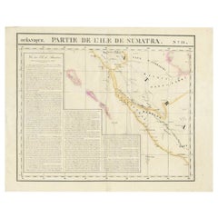
Detailed Antique Map of the Western Sumatra, Indonesia, circa 1825
Located in Langweer, NL
We offer a wide range of authentic antique maps for any budget.
Paper
$122Sale Price|72% Off
H 15.36 in W 20.08 in D 0 in
Antique Map of the Turkish Empire and Persia, circa 1890
By J. Migeon
Located in Langweer, NL
We offer a wide range of authentic antique maps for any budget.
Paper

$215Sale Price|20% Off
H 8.27 in W 10.63 in D 0.01 in
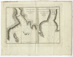
Antique Map of Port Pallisers & Kersmis by Cook, c.1781
Located in Langweer, NL
We offer a wide range of authentic antique maps for any budget.
Paper
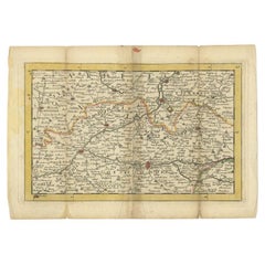

Antique Map of the Region of Soissons in France, 1737
Located in Langweer, NL
We offer a wide range of authentic antique maps for any budget.
Paper
$131Sale Price|20% Off
H 2.76 in W 5.12 in D 0 in
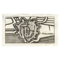
Antique Map of Harlingen, Harbour City in the Netherlands, 1691
Located in Langweer, NL
We offer a wide range of authentic antique maps for any budget.
Paper

Antique Map of the German Empire by Le Rouge, 1743
Located in Langweer, NL
We offer a wide range of authentic antique maps for any budget.
Paper
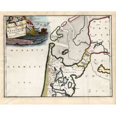

Antique Map of Westfriesland in Ancient Times by Alting, 1697
Located in Langweer, NL
We offer a wide range of authentic antique maps for any budget.
Paper

Antique Map of the Region of Oranjewoud by Kuyper, 1868
Located in Langweer, NL
We offer a wide range of authentic antique maps for any budget.
Paper
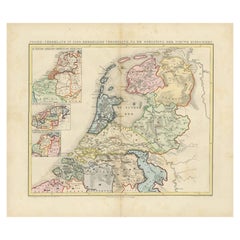

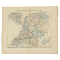
Antique Map of the Netherlands in 1560 by Mees, 1853
Located in Langweer, NL
We offer a wide range of authentic antique maps for any budget.
Paper
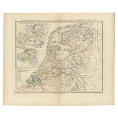

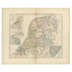
Antique Map of the Netherlands in 1530 by Mees, 1852
Located in Langweer, NL
We offer a wide range of authentic antique maps for any budget.
Paper
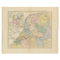

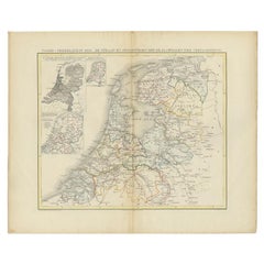
Antique Map of the Netherlands in 1811 by Mees, 1858
Located in Langweer, NL
We offer a wide range of authentic antique maps for any budget.
Paper
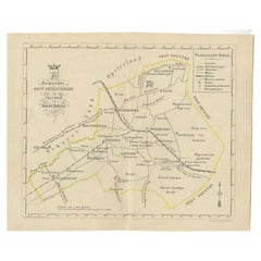

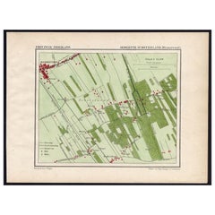
Antique Map of the Oost-Stellingwerf Township by Behrns, 1861
Located in Langweer, NL
We offer a wide range of authentic antique maps for any budget.
Paper

Antique Map of the Netherlands in 1839 by Mees, 1860
Located in Langweer, NL
We offer a wide range of authentic antique maps for any budget.
Paper

Antique Map of the Netherlands in 1590 by Mees, 1854
Located in Langweer, NL
We offer a wide range of authentic antique maps for any budget.
Paper
Antique Map of the Netherlands in 1859 by Mees, 1861
Located in Langweer, NL
We offer a wide range of authentic antique maps for any budget.
Paper

Antique Map of the Hemelumer Oldeferd Township by Behrns, 1861
Located in Langweer, NL
We offer a wide range of authentic antique maps for any budget
Paper

Antique Map of the Oost-Dongeradeel Township by Behrns, 1861
Located in Langweer, NL
We offer a wide range of authentic antique maps for any budget.
Paper