Items Similar to Antique Map of the German Empire by Le Rouge, 1743


Want more images or videos?
Request additional images or videos from the seller
1 of 5
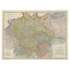
Antique Map of the German Empire by Le Rouge, 1743
About the Item
Antique map Germany titled 'L'Empire d'Allemagne dedie a Monseigneur Amelot (..)'. Antique map of the German Empire, with outline coloring.
Artists and Engravers: Published by G.L. le Rouge, Paris.
Condition: Good, general age-related toning. Please study image carefully.
Date: 1743
Overall size: 29.5 x 23 cm.
Image size: 27 x 20 cm.
We sell original antique maps to collectors, historians, educators and interior decorators all over the world. Our collection includes a wide range of authentic antique maps from the 16th to the 20th centuries. Buying and collecting antique maps is a tradition that goes back hundreds of years. Antique maps have proved a richly rewarding investment over the past decade, thanks to a growing appreciation of their unique historical appeal. Today the decorative qualities of antique maps are widely recognized by interior designers who appreciate their beauty and design flexibility. Depending on the individual map, presentation, and context, a rare or antique map can be modern, traditional, abstract, figurative, serious or whimsical. We offer a wide range of authentic antique maps for any budget.
- Dimensions:Height: 9.06 in (23 cm)Width: 11.62 in (29.5 cm)Depth: 0 in (0.01 mm)
- Materials and Techniques:
- Period:
- Date of Manufacture:1743
- Condition:
- Seller Location:Langweer, NL
- Reference Number:
About the Seller
5.0
Platinum Seller
These expertly vetted sellers are 1stDibs' most experienced sellers and are rated highest by our customers.
Established in 2009
1stDibs seller since 2017
1,929 sales on 1stDibs
Typical response time: <1 hour
- ShippingRetrieving quote...Ships From: Langweer, Netherlands
- Return PolicyA return for this item may be initiated within 14 days of delivery.
More From This SellerView All
- Large Antique Map of the German EmpireLocated in Langweer, NLAntique map titled 'A Map of Germany (..)'. Large antique map of the German Empire, highly detailed. Engraved by T. Kitchin. Published J. Blair, cir...Category
Antique Late 18th Century Maps
MaterialsPaper
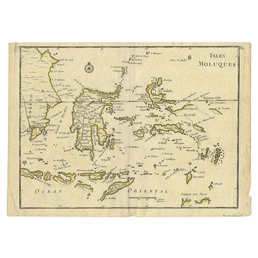
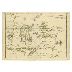
- Antique Map of the Maluku Islands by Le Rouge, c.1750By George Louis Le RougeLocated in Langweer, NLAntique map Moluccas/Spice Islands titled 'Isles Moluques'. Detailed map of the famous Spice Islands (Maluku Islands or the Moluccas). Includes also Sulawesi, Bali, Timor, part of Bo...Category
Antique 18th Century Maps
MaterialsPaper
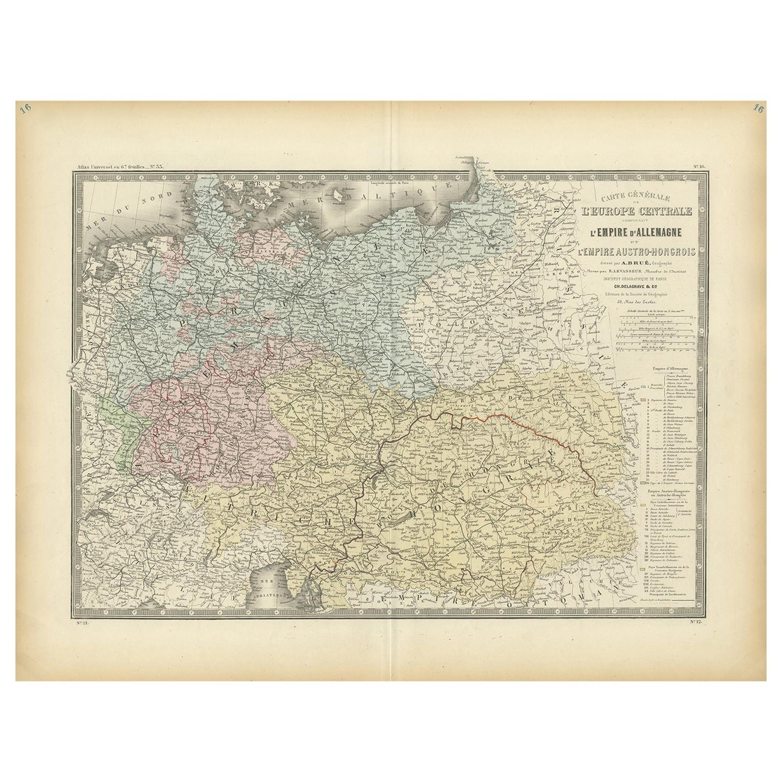
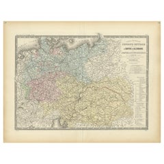
- Antique Map of the German Empire by Levasseur, '1875'Located in Langweer, NLAntique map titled 'Carte générale de l'Europe Centrale (..)'. Large map of the German Empire. This map originates from 'Atlas de Géographie Moderne Phys...Category
Antique Late 19th Century Maps
MaterialsPaper
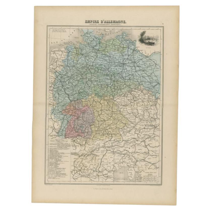
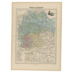
- Antique Map of the German Empire by Migeon, 1880Located in Langweer, NLAntique map titled 'Empire d'Allemagne'. Old map of Germany. With decorative vignette of Mainz. This map originates from 'Géographie Universelle Atlas-Migeon' by J. Migeon. Artist...Category
Antique 19th Century Maps
MaterialsPaper
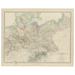
- Antique Map of the German Empire by Johnston, 1882By Alexander Keith JohnstonLocated in Langweer, NLAntique map titled 'Empire of Germany'. Old map of the German Empire with an inset map of Berlin and Potsdam. This map originates from 'The Royal Atlas o...Category
Antique 19th Century Maps
MaterialsPaper
- Antique Map of the German Empire by Johnston, '1909'Located in Langweer, NLAntique map titled 'Empire of Germany'. Original antique map of the German Empire. With inset maps of Berlin and Potsdam. This map originates from the ‘R...Category
Early 20th Century Maps
MaterialsPaper

You May Also Like
- 1861 Topographical Map of the District of Columbia, by Boschke, Antique MapLocated in Colorado Springs, COPresented is an original map of Albert Boschke's extremely sought-after "Topographical Map of the District of Columbia Surveyed in the Years 1856 ...Category
Antique 1860s American Historical Memorabilia
MaterialsPaper
- Super Rare Antique French Map of Chine and the Chinese Empire, 1780Located in Amsterdam, Noord HollandSuper Rare Antique French Map of Chine and the Chinese Empire, 1780 Very nice map of Asia. 1780 Made by Bonne. Additional information: Type: Map ...Category
Antique 18th Century European Maps
MaterialsPaper
- Le Cercle RougeLocated in London, GBOriginal Japanese poster for the Le Cercle Rouge, 1970. This film was written and directed by Jean-Pierre Melville and starred Alain Delon, Bourvil an...Category
Vintage 1970s Japanese Posters
MaterialsPaper
- Antique Carte de L'Inde Myanmar, Malaysia Vietnam Map of Asia the Chinese EmpireLocated in Amsterdam, Noord HollandAntique Carte de L'Inde Myanmar, Malaysia Vietnam Map of Asia the Chinese Empire Very nice map of Asia. Additional information: Type: Map Country of Man...Category
Antique 18th Century European Maps
MaterialsPaper
- East German MapBy VEB Hermann HaackLocated in Baltimore, MDA brilliantly colourful map of the Leipzig, Karl Marx Stadt and Dresden area in the former German Democratic Republic by VEB Hermann Haack of Gotha.Category
Vintage 1970s German Maps
- Original Antique Map of The World by Thomas Clerk, 1817Located in St Annes, LancashireGreat map of The Eastern and Western Hemispheres On 2 sheets Copper-plate engraving Drawn and engraved by Thomas Clerk, Edinburgh. Published by Mackenzie And Dent, 1817 ...Category
Antique 1810s English Maps
MaterialsPaper


Recently Viewed
View AllMore Ways To Browse
For The Empire
German Empire Furniture
German Empire
Historical Maps Germany
A D Allemagne
Antique Map German Empire
Premier Antiques
Compass 18th Century
18th Century Compass
Antique Furniture Building Plans
Antique Spain Map
Large City Maps
Spain Antique Map
Antique Japanese Map
Antique Maps Of Spain
Antique Map Of Spain
Military Map
Antique Japanese Maps