Items Similar to Antique Map of Barbary and Biledulgerid by Sanson, 1705


Want more images or videos?
Request additional images or videos from the seller
1 of 6
Antique Map of Barbary and Biledulgerid by Sanson, 1705
About the Item
Antique map, titled: 'Gedeelte van Barbaryen (…).' - Decorative hand colored map of a part of Barbary (Algeria) and Biledulgerid (Tegoryn, Zeb etc.), North Africa. Source unknown, to be determined.
Artists and Engravers: Made by 'Nicholas Sanson d'Abbeville' after an anonymous artist. Nicholas Sanson d'Abbeville (1600 - 1667) and his descendents were important French cartographer's active through the 17th century. Sanson started his career as a historian where, it is said, he turned to cartography as a way to illustrate his historical studies. In the course of his research some of his fine maps came to the attention of King Louis XIII who, admiring the quality of his work, appointed Sanson 'Geographe Ordinaire du Roi'. Sanson's duties in this coved position included advising the King on matters of Geography and compiling the royal cartographic archive. Sanson's corpus of some three hundred maps initiated the golden age of French Cartography.
Condition: Good, given age. Damp stained upper left. Some staining in the margins. Original folds as issued. General age-related toning and/or occasional minor defects from handling. Please study scan carefully.
Date: 1705
Overall size: 29 x 21.6 cm.
We sell original antique maps to collectors, historians, educators and interior decorators all over the world. Our collection includes a wide range of authentic antique maps from the 16th to the 20th centuries. Buying and collecting antique maps is a tradition that goes back hundreds of years. Antique maps have proved a richly rewarding investment over the past decade, thanks to a growing appreciation of their unique historical appeal. Today the decorative qualities of antique maps are widely recognized by interior designers who appreciate their beauty and design flexibility. Depending on the individual map, presentation, and context, a rare or antique map can be modern, traditional, abstract, figurative, serious or whimsical.
- Dimensions:Height: 8.51 in (21.6 cm)Width: 11.42 in (29 cm)Depth: 0 in (0.01 mm)
- Materials and Techniques:
- Period:
- Date of Manufacture:1705
- Condition:Condition: Good, given age. Damp stained upper left. Some staining in the margins. Original folds as issued. General age-related toning and/or occasional minor defects from handling. Please study scan carefully.
- Seller Location:Langweer, NL
- Reference Number:
About the Seller
5.0
Platinum Seller
These expertly vetted sellers are 1stDibs' most experienced sellers and are rated highest by our customers.
Established in 2009
1stDibs seller since 2017
1,932 sales on 1stDibs
Typical response time: <1 hour
- ShippingRetrieving quote...Ships From: Langweer, Netherlands
- Return PolicyA return for this item may be initiated within 14 days of delivery.
More From This SellerView All
- Antique Map of Russia by N. Sanson, 1705Located in Langweer, NLA strongly engraved map of European Russia showing its political divisions, major topographical features, cities and towns. Extends to the Sea of Azov and the tip of the Caspian Sea ...Category
Antique Early 18th Century Maps
MaterialsPaper
- Antique Map of Asia by Sanson, circa 1705By Nicolas SansonLocated in Langweer, NLDutch edition of Sanson's map of Asia. Shows a large, dramatic version of Terre de Jesso, drawn from the discoveries of the Maarten de Vries expedition of 1643.Category
Antique Early 18th Century Dutch Maps
MaterialsPaper
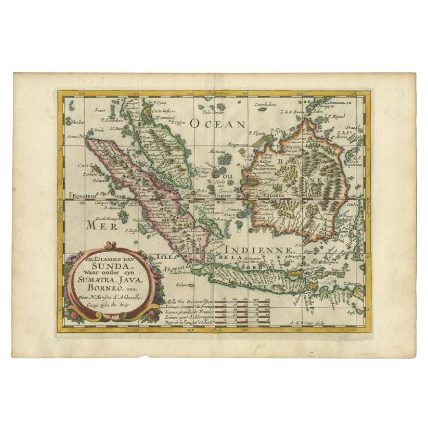
- Antique Map of the Bangka Belitun Island by Sanson, 1705Located in Langweer, NLAntique map Sunda Islands titled 'De Eilanden van Sunda, waar onder zyn Sumatra, Java, Borneo enz'. Old map of the Bangka Belitun Islands, part of the Greater Sunda Islands, includin...Category
Antique 18th Century Maps
MaterialsPaper
- Antique Map of Japan and Korea by Sanson, 'c.1690'Located in Langweer, NLAntique map titled 'Les Iles du Iapon (..)'. Original antique map, with beautiful (later) hand coloring, of Japan and the Island of Corey (Korea). Uncommon edition, with '234' at top...Category
Antique Late 17th Century Maps
MaterialsPaper
- Antique Map of Madagascar by N. Sanson, circa 1680By Nicolas SansonLocated in Langweer, NLAntique map titled 'Isle de Madagascar ou de St. Laurens. Tiree de Sanutu &c'. Antique map of Madagascar, first published by Sanson in 1657. Sanson n...Category
Antique Late 17th Century Maps
MaterialsPaper
- Antique Map of India and Southeast Asia by Sanson '1654'Located in Langweer, NLAntique map titled 'Partie Meridionale de l'Inde'. Early map of India and Southeast Asia. The map shows most of modern India, Bangladesh and Burma, the whole of Sri Lanka, Thailand, ...Category
Antique Mid-17th Century Maps
MaterialsPaper


You May Also Like
- 1705 Golfe de Mexico and Florida Framed MapLocated in Stamford, CTFramed map of Mexico & Florida circa 1705, Paris. Small map with Mexico and the Gulf Coast. Inset text indicating Panama, Acapulco, Mexico City and the Mississippi. Extends North to ...Category
Antique Early 1700s French Spanish Colonial Maps
MaterialsGlass, Wood, Paper
- The Normandy Region of France: A 17th C. Hand-colored Map by Sanson and JaillotBy Nicolas SansonLocated in Alamo, CAThis large hand-colored map entitled "Le Duché et Gouvernement de Normandie divisée en Haute et Basse Normandie en divers Pays; et par evêchez, avec le Gouvernement General du Havre ...Category
Antique 1690s French Maps
MaterialsPaper
- "Africa Vetus": a 17th Century Hand-Colored Map by SansonBy Nicolas SansonLocated in Alamo, CAThis original hand-colored copperplate engraved map of Africa entitled "Africa Vetus, Nicolai Sanson Christianiss Galliar Regis Geographi" was originally created by Nicholas Sanson d...Category
Antique Late 17th Century French Maps
MaterialsPaper
- 17th Century Map of Denmark by French Cartographer Sanson, Dated 1658By Nicolas SansonLocated in Copenhagen, K17th century map of Denmark by French cartographer Sanson. Nicolas Sanson (20 December 1600-7 July 1667) was a French cartographer, termed by some the creator of French geography an...Category
Antique 17th Century French Maps
MaterialsPaper
- Portugal: A Large 17th Century Hand-colored Map by Sanson and JaillotBy Nicolas SansonLocated in Alamo, CAThis large hand-colored map entitled "Le Royaume de Portugal et des Algarves Divisee en see Archeveches, Eveches et Territoires Par le Sr Sanson" was originally created by Nicholas S...Category
Antique 1690s French Maps
MaterialsPaper
- Africa: A Large 17th Century Hand-Colored Map by Sanson and JaillotBy Nicolas SansonLocated in Alamo, CAThis large original hand-colored copperplate engraved map of Africa entitled "L'Afrique divisee suivant l'estendue de ses principales parties ou sont distingues les uns des autres, L...Category
Antique 1690s French Maps
MaterialsPaper


Recently Viewed
View AllMore Ways To Browse
Antique Cartography
King Size Antique French
North Africa Map
Antique Corpus
16th Century Hand Colored Map
17th Century Corpus
Algeria Antique Map
Hand Painted Antique Map
Antique Furniture Depot
17th Century Scottish
Antique Road Maps
Antique Road Map
Antique Map Of Mexico
Antique Maps Of Mexico
Antique Style Atlas
Nautical Map
Nautical Maps
Antique Ship Decor