
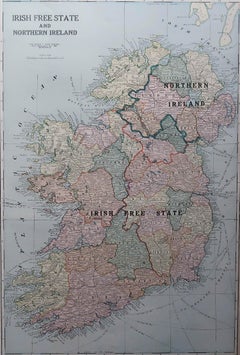
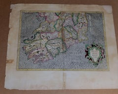
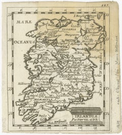
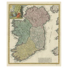
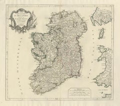
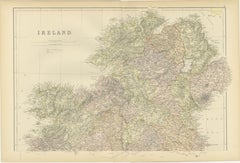
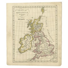
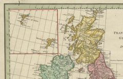
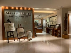
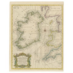
Large Original Antique Map of Ireland. C.1900
Located in St Annes, Lancashire
Fabulous map of Ireland Original color. Engraved and printed by the George F. Cram Company
Category
Antique 1890s American Maps
Materials
Paper
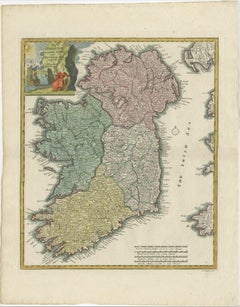
Large Original Antique Map of Ireland. C.1900
Located in St Annes, Lancashire
Fabulous map of Ireland Original color. Engraved and printed by the George F. Cram Company
Paper
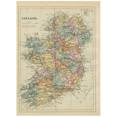
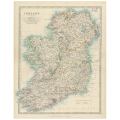
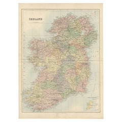
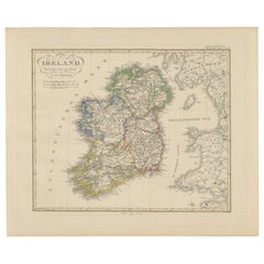
Antique Map of Ireland, 1885 – County Colors, Railways & Coastal Detail
Located in Langweer, NL
Title: Antique Map of Ireland, 1885 – County Colors, Railways & Coastal Detail Description: This
Paper
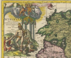
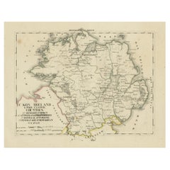
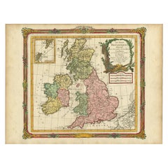
1585 Mercator Map of Ireland, Entitled "Irlandiae Regnvm, " Hand Colored Ric0006
Located in Norton, MA
1585 Mercator map of Ireland, entitled "Irlandiae Regnvm." Hand Colored Description
Paper
Antique Map of Ireland, 1903, with Intricate County Boundaries & Coastal Details
Located in Langweer, NL
Title: Antique Map of Ireland, 1903, with Intricate County Boundaries and Coastal Detail
Paper

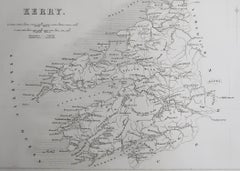
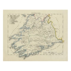
Original Antique Map of Ireland- Kerry. C.1840
Located in St Annes, Lancashire
Great map of Kerry Steel engraving Drawn under the direction of A.Adlard Published by How and
Paper

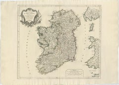
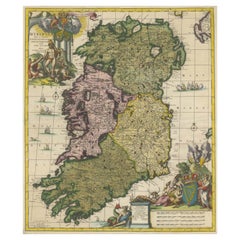
Irlandia – Antique Miniature Map of Ireland, Latin Cartography by Du Val c.1679
Located in Langweer, NL
Title: IRLANDIA – Antique Map of Ireland, Latin Cartography by Du Val c.1650 Description: This
Paper

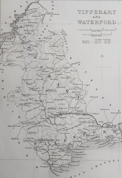
Original Antique Map of Ireland- Tipperary and Waterford. C.1840
Located in St Annes, Lancashire
Great map of Tipperary and Waterford Steel engraving Drawn under the direction of A.Adlard
Paper

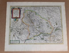
1636 Jansson Map of Ireland Entitled "Comitatus Lageniae, " Ric.a007
Located in Norton, MA
1646 Jansson map entitled "Procinvia connactiae," Ric.a006 Description: The PROVINCE of
Paper

$415Sale Price|20% Off
Map of Ireland: Early 19th Century - from the 1802 Tardieu Atlas
Located in Langweer, NL
Revolutionary Calendar) **Geographical Scope:** This antique map illustrates Ireland, providing a detailed
Paper
$2,281Sale Price|25% Off
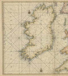
Large 1693 Maritime Map of Irish Sea, West Coasts of Ireland, England, Scotland
Located in Langweer, NL
Ireland together with the western coasts of England and Wales and parts of western Scotland. It was first
Paper
$1,002
Circa 1960 Historical Map of Ireland by Leslie George Bullock
Located in PARIS, FR
This richly detailed Historical Map of Scotland, created around circa 1960 by Leslie George Bullock
Paper
Decorative Hand-Coloured Antique Map of the Four Irish Provinces, Ireland, c1718
Located in Langweer, NL
Title: Regni Hiberniae Accurata Tabula per Hermanum Moll Decorative map of the four Irish
Paper

Antique Ireland Map with County Divisions – Decorative Wall Chart, 1884
Located in Langweer, NL
Antique Map of Ireland with Counties – Black’s Atlas, 1884 Description: This finely detailed
Paper
Ireland Antique Map – Royaume d’Irlande, De Vaugondy, Venice 1778
Located in Langweer, NL
Antique Map of Ireland – Royaume d’Irlande, Robert de Vaugondy, Venice 1778 Description: This
Paper
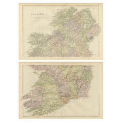
Ireland Map – Provincial and County Divisions 1851
Located in Langweer, NL
Ireland Map – Provincial and County Divisions 1851 This fine antique print shows Ireland titled
Paper
$1,981Sale Price|30% Off
Hibernia Regnum Map by Carel Allard, 1700: Hand-Colored Provinces of Ireland
Located in Langweer, NL
This is a historical map of Ireland created by Carel Allard around 1700, titled "Hibernia Regnum in
Paper
1882 Cartographic Views of Ireland's North and South Regions
Located in Langweer, NL
Title: 1882 Maps of Ireland: Northern and Southern Regions These two maps provide a detailed
Paper

$271Sale Price|20% Off
Antique Map of New Ireland, 1774
Located in Langweer, NL
Antique print titled 'Neu Irrland (..)'. Antique map of New Ireland with 7 coastal profiles, Papua
Paper
$216Sale Price|20% Off
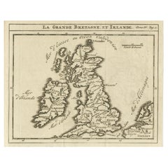
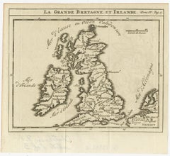
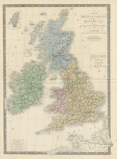
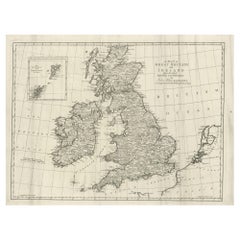
Rare Small Antique Map of Great Britain and Ireland
Located in Langweer, NL
Antique map titled 'La Grande Bretagne et Irlande'. Small antique map of Great Britain and Ireland
Paper

$271Sale Price|20% Off
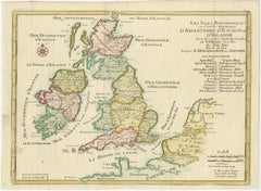
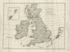
Original Antique Map of England, Ireland, Scotland and Wales
Located in Langweer, NL
Antique map titled 'Les Isles Britanniques, ou sont les Royaumes d Angleterre (..)'. Detailed map
Paper


$122Sale Price|20% Off
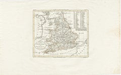
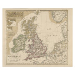
Antique Map of the United Kingdom and Ireland, 1852
Located in Langweer, NL
Antique map titled 'Groot-Brittanje en Ierland'. Map of the United Kingdom and Ireland. This map
Paper


Antique Map of England and Ireland by Lattre, 1789
Located in Langweer, NL
Antique map titled 'Les Royaumes d'Angleterre d'Ecosse et d'Irlande'. Original antique map of
Paper


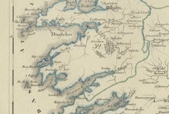
Lakes of Killarney Map, County Kerry Ireland, Bacon London, 1885
Located in Langweer, NL
Lakes of Killarney Map, County Kerry Ireland, Bacon London 1885 Description: This finely engraved
Paper

$245Sale Price|20% Off
Detailed Antique Map of Britain, Wales and the Coast of Ireland
Located in Langweer, NL
and the coast of Ireland with a list of counties. This map originates from 'Nuovo Atlante Di Geografia
Paper

$132Sale Price|20% Off
Antique Map of the United Kingdom and Ireland, circa 1825
Located in Langweer, NL
Antique map titled 'Insula Britannicae'. Old map of the United Kingdom and Ireland originating from
Paper


$116Sale Price|20% Off
Antique Map of the United Kingdom and Ireland, c.1873
Located in Langweer, NL
Antique map titled 'Groot Brittanje en Ierland'. Old map depicting the United Kingdom and Ireland
Paper
Antique Map of Britain & Ireland with North Sea Detail – 1856 Stülpnagel
Located in Langweer, NL
prominently marked. Ireland is shown in full with its provincial boundaries, while Scotland is mapped with
Paper
$858Sale Price|35% Off
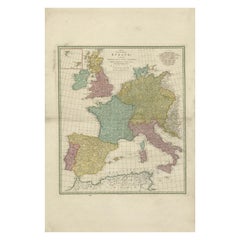
1788 Map of Europe - France, Italy, Spain, Germany, Great Britain & Ireland
Located in Langweer, NL
Title: "1788 Map of Europe - France, Italy, Spain, Germany, Great Britain & Ireland by
Paper
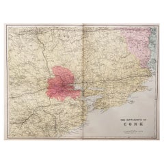
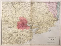
Large Original Antique Map of the Environs of Cork, Ireland, circa 1880
Located in St Annes, Lancashire
Great map of The Environs of Cork Published circa 1880 Unframed Free shipping.
Paper
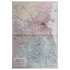
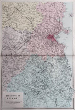
Large Original Antique Map of The Environs of Dublin, Ireland, circa 1880
Located in St Annes, Lancashire
Great map of The Environs of Dublin Published circa 1880 Unframed Free shipping.
Paper
Antique 1830 Map of Leinster, Ireland with Dublin, Kilkenny, Wexford and Kildare
Located in Langweer, NL
Title: Antique 1830 Map of Leinster, Ireland with Dublin, Kilkenny, Wexford, and Kildare
Paper

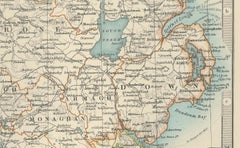
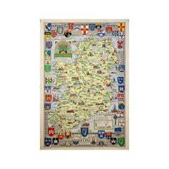
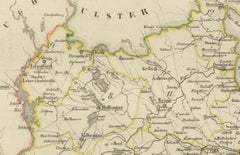
Antique 1830 Map of Ulster, Ireland with Armagh, Down, Antrim, Donegal, Tyrone
Located in Langweer, NL
Title: Antique 1830 Map of Ulster, Ireland with Armagh, Down, Antrim, Donegal, and Tyrone
Paper
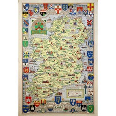
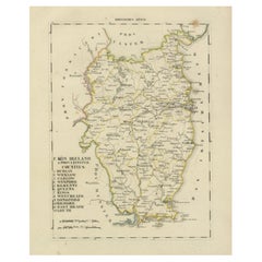
Antique 1830 Map of Munster, Ireland with Limerick, Cork, Kerry and Tipperary
Located in Langweer, NL
Title: Antique 1830 Map of Munster, Ireland with Limerick, Cork, Kerry, and Tipperary
Paper

Antique Map of New Ireland (Pacific) with Coastal Profiles – Cook Voyages, 1774
Located in Langweer, NL
Antique Pacific Map of New Ireland with Coastal Profiles – Cook Voyages, 1774 Antique engraved map
Paper


$433Sale Price|20% Off
Small Antique Map of England, Wales, Scotland and Ireland with Original Coloring
Located in Langweer, NL
Antique map titled 'Les Royaumes d'Angleterre d'Escosse et d'Irlande (..)'. A lovely, small map of
Paper

$288Sale Price|30% Off
Original Antique Map of the United Kingdom and Ireland, Published in 1875
Located in Langweer, NL
United Kingdom and Ireland. This map originates from 'Atlas de Géographie Moderne Physique et Politique
Paper

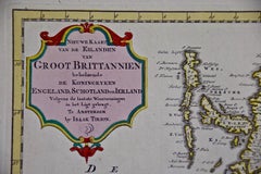
England, Scotland & Ireland: A Hand Colored Map of Great Britain by Tirion
By Isaak Tirion
Located in Alamo, CA
This is a hand-colored double page copperplate map of Great Britain entitled "Nieuwe Kaart van de
Paper

Antique Map of the Coast of New Ireland, Earlier Part of German New Guinea, 1833
Located in Langweer, NL
. New Ireland, also New Mecklenburg, is the Northeastern Province of Papua New Guinea. Map no. 26 from
Paper

Old Map of the UK & Ireland, Insets of Orkney, Shetland and Faroe Islands, 1786
Located in Langweer, NL
". Hand-colored engraved map with 2 (large) decorative cartouches, inset map of the Orkney, Shetland and
Paper
Antique Map of New Ireland Island in the Bismarck Archipelago, New Guinea, 1772
Located in Langweer, NL
Antique map titled 'Nova Hibernia'. Antique map of New Ireland, an island in the Bismarck
Paper
Antique Map of Great Britain and Ireland by Brion de la Tour, 1766
Located in Langweer, NL
Antique map titled 'Les Isles Britanniques (..).' Attractive map of Great Britain surrounded by
Paper

1633 Map Entitled "Beauvaisis Comitatus Belova Cium, Ric.0002
Located in Norton, MA
. 1591-92 Hiberniae novissima descrzptio: Boazio\\\\\\\\\\\\\\\'s map of Ireland: Engraved by Pieter van
Paper


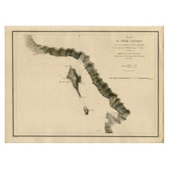
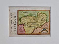
Southeastern Ireland: A 17th Century Hand Colored Map by Mercator and Hondius
By Gerard Mercator
Located in Alamo, CA
A 17th century copperplate hand-colored map entitled "The Second Table of Ireland, Udrone" by
Paper
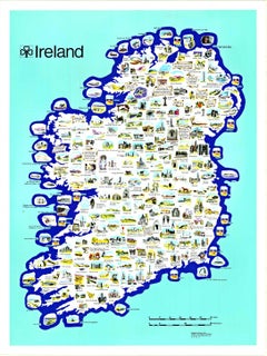
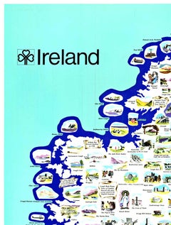
Original Ireland Pictorial Vintage Poster Travel Map linen backed
Located in Spokane, WA
Original Ireland Pictorial Map, archival linen-backed, Grade A, ready to frame. This poster has no
Lithograph
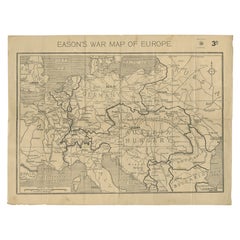

Eason's War Map of Europe, circa 1914
Located in Langweer, NL
Antique map titled 'Eason's War Map of Europe'. Printed in Ireland. Source unknown, to be
Paper
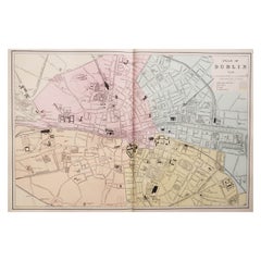
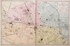
Large Original Antique City Plan of Dublin, Ireland, circa 1880
Located in St Annes, Lancashire
Great city plan of Dublin Published circa 1880 Unframed Free shipping. .
Paper
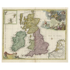
Large Antique Map of the British Isles, inset of the Orkneys and Shetlands, 1779
Located in Langweer, NL
Antique map titled 'A Map of Great Britain and Ireland (..)'. Large antique map of the British
Paper
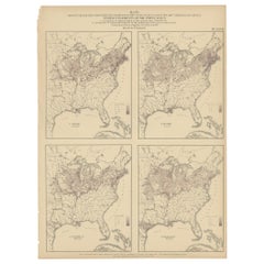
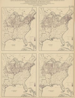
Antique Chart of the US Irish and German Population in 1870, '1874'
Located in Langweer, NL
Antique chart titled 'Maps showing the distribution, within the territory of the United States
Paper

$205Sale Price|20% Off
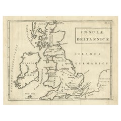
Antique Map of the British Isles with Walls, Settlements and Other Features
Located in Langweer, NL
Antique map titled 'Insulae Britannicae'. Interesting map of Britain, Scotland, and Ireland. It
Paper
$168Sale Price|20% Off
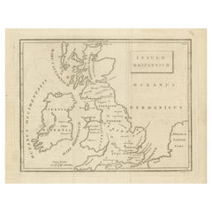
Old Map of British Isles According to the Geography of the Roman Empire, ca.1790
Located in Langweer, NL
Antique map titled 'Insulae Britannicae'. Interesting map of Britain, Scotland, and Ireland. It
Paper
$622Sale Price|20% Off
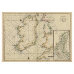
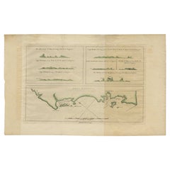
Hand-colored Nautical Chart: St. George's Channel and the Irish Sea, 1744
Located in Langweer, NL
. Here are the key details and features of the map: The map covers the region of the Irish Sea
Paper
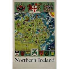
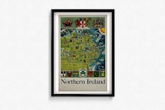
Griffin's 1955 Northern Ireland original map - Tourism - Geography
Located in PARIS, FR
Griffin's 1955 Northern Ireland map stands out as a captivating representation of the region's
Linen, Paper, Lithograph
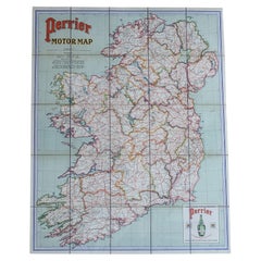
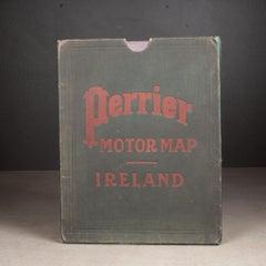
Early 20th c. Ireland Perrier Motor Map c.1910
Located in San Francisco, CA
ABOUT Large bright vivid color-printed Perrier Motor Map, featuring the motoring roads of Ireland
Linen, Paper

$675
Southeastern Ireland: A 17th Century Hand Colored Map by Mercator and Hondius
By Gerard Mercator
Located in Alamo, CA
A 17th century copperplate hand-colored map entitled "The Second Table of Ireland, Udrone" by
Engraving
$1,002
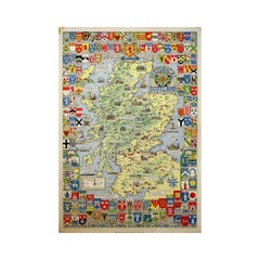
Circa 1960 Historical Map of Scotland by Leslie George Bullock
Located in PARIS, FR
This richly detailed Historical Map of Scotland, created around circa 1960 by Leslie George Bullock
Paper
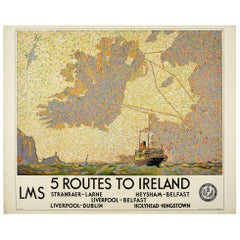
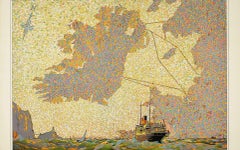
Original Vintage LMS London Midland Scottish Railway Poster 5 Routes To Ireland
Located in London, GB
sailing boats near the rocky coast and a colourful map image of Ireland showing the sailing routes to or
Paper
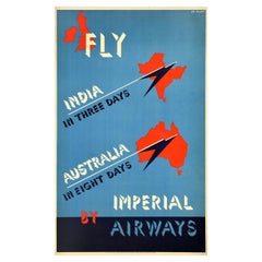
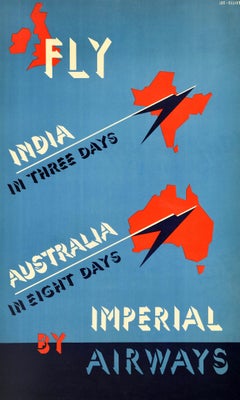
Original Vintage Travel Advertising Poster Fly Imperial Airways India Australia
By David Lee Theyre Elliott
Located in London, GB
in eight days - featuring the stylised bold text over red map shapes of the UK and Ireland at the top
Paper
Produced in 1843, the well-preserved volume is evidence of the author's exacting specifications.
New or old, the coverlets add old-time charm to any space.
Get into the games! These items celebrate the events, athletes, host countries and sporting spirit.
French trendsetter and serial collector Daniel Rozensztroch tells us about his obsession with objects related to seafaring men.
It's hard to resist the allure of a beautiful pool. So, go ahead and daydream about whiling away your summer in paradise.
The sought-after designer worked with the team at Hoffman Creative to produce a monograph that beautifully showcases some of Studio Shamshiri's most inspiring projects.
Italian writer and collector Umberto Pasti opens the doors to his remarkable cave of wonders in North Africa.
Hollywood A-listers, ex-pat aristocrats and art collectors and style setters of all stripes appreciate the allure of the coastal California hamlet — much on our minds after recent winter floods.