
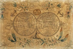
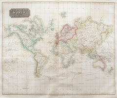
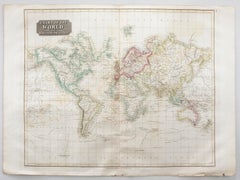
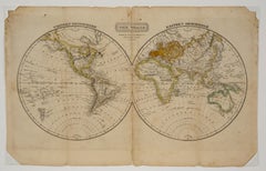
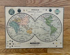
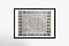
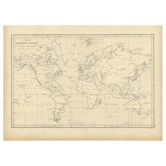
Map of the World - Original Etching - 1820
Located in Roma, IT
Map of the World is an Original Etching realized by an unknown artist of 19th century in 1820.
Category
1820s Modern Antique World Maps
Materials
Etching
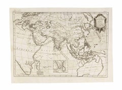
Map of the World - Original Etching - 1820
Located in Roma, IT
Map of the World is an Original Etching realized by an unknown artist of 19th century in 1820.
Etching

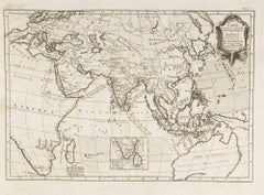
Antique Map of the World by Ferrario '1831'
Located in Langweer, NL
Original antique map of the world. This print originates from 'Costume Antico e Moderno: Palestine, China, India, Oceania' by Ferrario.
Paper
$1,287
H 12.6 in Dm 7.88 in
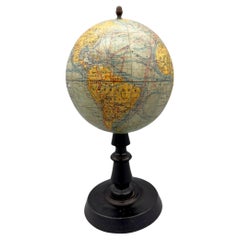
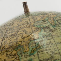
Small terrestrial globe by Joseph Forest, Paris, France, circa 1890 / 1900
Located in Paris, FR
In 1886, at 17-19 rue de Buci, he founded his own publishing house for maps and plans, world maps, globes, terrestrial and celestial spheres, charts and wall maps for educational use.
Wood, Paper

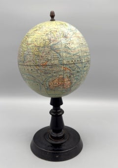
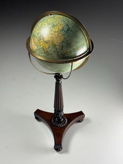
Large terrestrial globe by Joseph Forest, Paris, France, circa 1890
Located in Paris, FR
In 1886, at 17-19 rue de Buci, he founded his own publishing house for maps and plans, world maps, globes, terrestrial and celestial spheres, charts and wall maps for educational use.
Brass
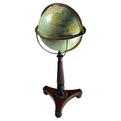
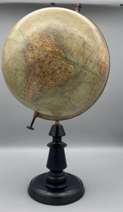
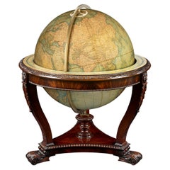
Terrestrial Globe William IV
Located in MILL, NL
The globe itself shows a world map by Columbus Jordglobe of Sweden (c. 1938), depicting shipping lanes and ocean currents, making it both educational and visually captivating.
Wood

$1,275
H 15.75 in W 19.63 in
Map of the World: An Original 18th Century Hand-colored Map by E. Bowen
By Emanuel Bowen 1
Located in Alamo, CA
This highly detailed and colorful map depicts the world. as it was known in the mid 18th century.
Engraving
19th Century Embroidered Silk Panel Map Of The World
Located in Forney, TX
Exquisitely hand-crafted in Continental Europe in the 19th century, depicting map of the world, double hemisphere, having a highly attractive appearance, with finely worked details, ...
Silk, Thread
$877
H 14.69 in W 19.77 in D 0.04 in
Carte Pour Servir a l'Histoire Philosophique.. - Etching by Rigobert Bonne- 1780
Located in Roma, IT
From Guillaume-Thomas Raynal, Histoire philosophique et politique des établissemens et du commerce des Européens dans les deux Indes, Geneva 1780. This interesting world map covers ...
Etching
$6,845 / set
H 23.23 in W 28.35 in D 1.97 in
G De l'Isle- Ieremiah Wolff- 6 Engravings On The Continents, 18th Century
Located in MARSEILLE, FR
A beautiful set of six framed engravings depicting geographical maps of the five continents and a world map, enhanced with color.
Paper
$395
H 20.48 in W 24.41 in
John Thomson (1777-1840) - 1830 Map Engraving, Chart of the World
By John Thomson
Located in Corsham, GB
A fine engraved map of the world on Mercator's projection, from the second edition of John Thomson's 'New General Atlas' published in 1830.
Engraving
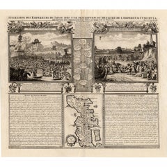
Maps of the Ancient World and the Posterity of Noah, 1820
Located in Langweer, NL
Two maps on one sheet. Hhand colored engraved lithograph, depicting the world as known to the Ancients on Mercator's projection and the Posterity of Noah.
Paper
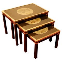
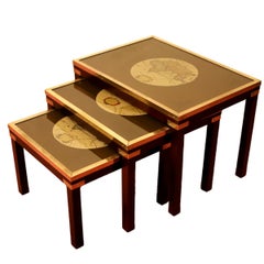
Beautiful Brass Bound Military Campaign Nesting Tables
Located in Crawley, GB
Beautiful Brass Bound Military Campaign Nesting Tables with glass top and decorative antique world map. Don't hesitate to contact me if you have any questions.
Brass
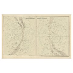

Antique Print of Celestial Hemispheres, 1854
Located in Langweer, NL
Antique world map titled 'Northern Celestial Hemisphere - Southern Celestial Hemisphere'.
Paper
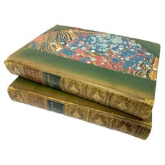
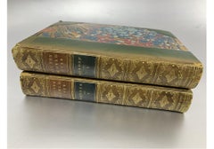
All The World Over By Edwin Hodder, 2 Vol Set 1876 With Maps
Located in Bridgeport, CT
"All the World Over" published in two volumes in 1875-1876 by T.
Leather, Paper
$437
H 20.08 in W 25.6 in
John Thomson (1777-1840) - 1830 Map Engraving, The Rivers of the World
By John Thomson
Located in Corsham, GB
A fine engraved chart table showing the lengths of the principal rivers across the world, from the second edition of John Thomson's 'New General Atlas' published in 1830. On paper.
Engraving

$304 / item
H 10.79 in W 13.59 in D 0.01 in
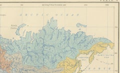
River Systems Map of the World by A.K. Johnston – Educational Print 1852
Located in Langweer, NL
River Systems Map of the World by A.K. Johnston – Educational Print 1852 This striking 1852 map titled "The River Systems of the World" was created by the noted Scottish geographer ...
Paper


$3,239
H 35.44 in W 24.02 in D 0.04 in
Original Antique Cruise Travel Poster Nippon Yusen Kaisha Japan Mail Steamship
Located in London, GB
Original antique cruise travel poster issued by the Nippon Yusen Kaisha shipping company to promote its home and foreign passenger services with its fleet of 80 vessels featuring a l...
Paper
$304 / item
H 10.79 in W 13.59 in D 0.01 in
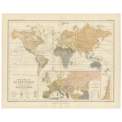
Ethnographic Map of the World by A.K. Johnston – Races of Man Chart 1852
Located in Langweer, NL
Ethnographic Map of the World by A.K. Johnston – Races of Man Chart 1852 This antique map titled "Ethnographic Map of the World Showing the Present Distribution of the Leading Races...
Paper

$1,950
H 20.13 in W 23.88 in D 0.94 in
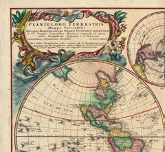
Planiglobii Terrestris Mappa Universalis / Mappe Monde
By Homann Heirs
Located in New York, NY
An attractive double hemisphere map of the world by the famous German cartographic family, Homann.
Engraving
$11,409Sale Price|25% Off
H 13.78 in W 15.36 in D 4.73 in
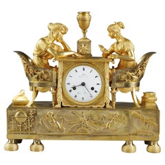
Empire Clock, "The Astronomy Lesson", early 19th century
Located in Paris, FR
A mercury gilt bronze clock depicting two young women dressed in antique style sitting in Etruscan-style shepherdesses on either side of a draped table with claw feet, studying a map...
Bronze
$1,638
H 28.75 in W 35.44 in
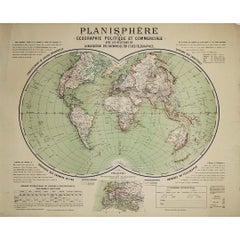
Circa 1900 original poster Planisphère de géographie politique et commercial
Located in PARIS, FR
The poster presents a detailed world map, rendered in a projection style that emphasizes the geopolitical and commercial landscapes of the era.
Paper, Lithograph

$19,000
H 24 in W 29 in D 1.25 in
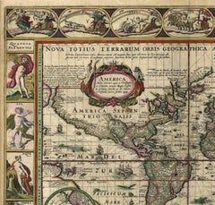
Nova Totius Terrarum Orbis Geographica Ac Hydrographica Tabula
Located in New York, NY
A classic example of a world map based on Mercator's projection. This beautiful carte-a-figures map of the world by Pieter van den Keere was based on Blaeu's almost identical map tha...
Engraving

Terrestrial Globe by W. & A.K. Johnston
By W. & A.K. Johnston
Located in New Orleans, LA
Spheres of such grand scale were incredibly expensive to create. At a time when the world’s map was constantly changing, it proved to be much more cost-effective to update one's plat...
Brass
$360Sale Price|20% Off
H 6.75 in W 7.5 in D 7.5 in
Italian Old World Desk Top Globe With Figural Brass Base 19thC
Located in Big Flats, NY
An antique Italian desk globe, dating to the 19th century, featuring an 'Old World' style map and presented on a decorative figural brass base.
Brass
$595
H 1.18 in W 0.77 in D 0.63 in
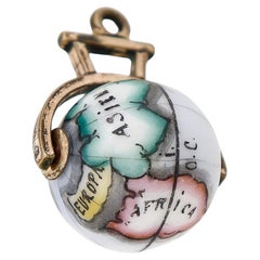
Antique Victorian Gold Plate & Porcelain Globe/World Spinner Charm or Pendant
Located in Philadelphia, PA
In the form of a porcelain bead decorated with a polychrome, simplified map of the world. Set with a gold plated yoke.
Gold Plate

$280Sale Price|20% Off
H 17.92 in W 14.18 in D 0.02 in
Antique Print of the World's Time Zones by Johnson, 1872
Located in Langweer, NL
Original print of the World's time zones. This map originates from 'Johnson's New Illustrated Family Atlas of the World' by A.J.
Paper
$500
H 20 in W 24 in D 0.5 in
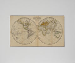
"The World" Published by Cummings & Hilliard, No. 1, Cornhill, Boston
Located in Soquel, CA
"The World" Published by Cummings & Hilliard, No. 1, Cornhill, Boston Early 19th century engraved double hemisphere Atlas Map, titled "The World."
Paper, Printer's Ink, Etching
$975
H 20 in W 22.63 in D 0.88 in
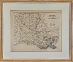
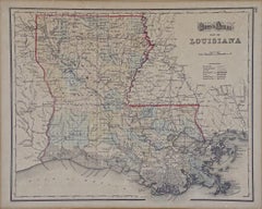
Louisiana: A Framed 19th Century Map by O.W. Gray
Located in Alamo, CA
This framed 19th century map of the Louisiana territory was published in "Gray's Atlas of the United States with General Maps of the World, accompanied by Descriptions Geographical, ...
Engraving
$750
H 2 in W 11 in D 8 in
Atlas Geographique Boxed French Geography Game Complete with 6 Maps Circa 1890
Located in San Francisco, CA
This extraordinary and complete puzzle set consists of maps of the world, Americas, Africa, Asia, Europe and France.
Pine, Paint, Paper

$1,975
H 21.5 in W 28 in D 0.75 in
Northern Italy: A 16th Century Hand-colored Map by Abraham Ortelius
By Abraham Ortelius
Located in Alamo, CA
He rapidly became proficient at mapmaking and printing, completing his “Mappemonde", a large and ambitious eight-sheet wall map of the world in 1564. Ortelius also published a map of...
Engraving

$468Sale Price|20% Off
H 18.71 in W 24.02 in D 0.02 in
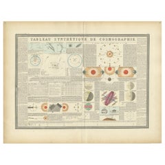
Antique Print of the Planetary Systems of the World by Levasseur, '1875'
Located in Langweer, NL
Large print depicting the planetary systems of the world. This map originates from 'Atlas de Géographie Moderne Physique et Politique' by A.
Paper

$1,850
H 20 in W 23.25 in
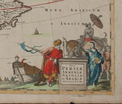
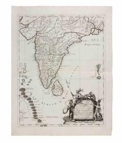
Persiae, Armeniae, Natoliae et Arabiae Descriptio per Frederick deWit 1666 map
Located in Paonia, CO
His works included sea and world atlases, wall maps, and town books containing plans of Dutch and European cities.
Engraving

$1,755
H 30.71 in W 39.38 in
1851 Original map by Maillard - Plan de Paris et ses Fortifications
Located in PARIS, FR
In the world of cartography, maps transcend mere geography; they are historical records and works of art, encapsulating the essence of a place at a specific moment in time.
Linen, Paper, Lithograph
$304 / item
H 10.79 in W 13.59 in D 0.01 in
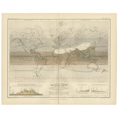
Rain and Snow Map by A.K. Johnston – Global Precipitation Chart 1852
Located in Langweer, NL
The map divides the world into meteorological zones based on the frequency and regularity of rainfall.
Paper

$1,053
H 23.63 in W 16.93 in
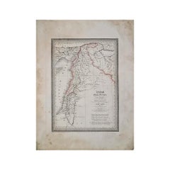
Circa 1825 original engraving of the map of Syria by Giraldon Bovinet
Located in PARIS, FR
Published as Numéro 47 by Ménard & Desenne, prominent French publishers at the time, this engraving is part of a broader series of maps that depicted the ancient and contemporary reg...
Paper, Engraving
$588
H 16.74 in W 18.71 in D 0 in
Antique Engravings of Japan incl a Map and the Arrival of the Dutch, 1732
Located in Langweer, NL
We sell original antique maps to collectors, historians, educators and interior decorators all over the world.
Paper
$497,332
H 67.72 in W 148.82 in D 0.79 in
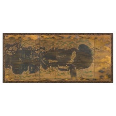
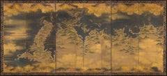
Paravents -A pair of six-fold screens depicting maritime routes in Seto sea, Edo
Located in Brussels, BE
After the introduction of the compass and astrolabe by the Portuguese during the Momoyama period (1573–1615), map making became considerably more accurate. The daimyo Oda Nobunaga (1...
Gold Leaf
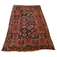
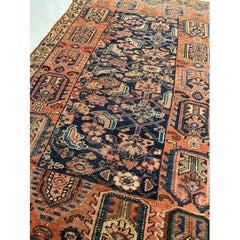
Mid-19th Century Persian Tribal Bidjar Rug
Located in Los Angeles, US
The city’s untimely establishment on the world’s maps coincided with the re-establishment of shipping ports and the gradual decline of the Silk Road.
Wool, Cotton

$19,775
H 37.6 in W 30.52 in D 2.76 in
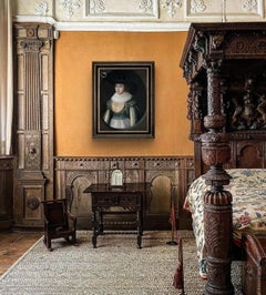
Rare Jacobean Portrait on Panel Lady Elizabeth Wheeler née Cole 1623 Historical
By Cornelius Johnson
Located in London, GB
Fourth, the social logic: Johnson’s clientele maps onto the world now revealed by the heraldry and biography.
Oil, Panel
$1,404
H 24.18 in W 18.71 in D 0.04 in
Penisola dell'India... - Etching by Giacomo Cantelli da Vignola - 1683
Located in Roma, IT
It is part of the Series "Mercurio Geografico or Geographical Guide to All Parts of the World...", collection of maps published in Rome by de Rossi between 1660 and 1730.
Etching

$205Sale Price|20% Off
H 12.33 in W 17.41 in D 0 in
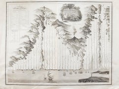
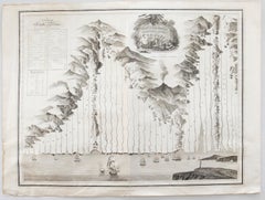
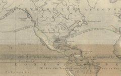
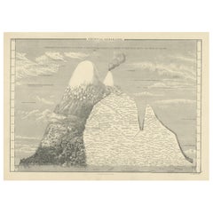
Antique Print of an Elevational Profile Near the Equator, 1854
Located in Langweer, NL
This map orginates from 'General Atlas Of The World: Containing Upwards Of Seventy Maps (..)' by Adam & Charles Black.
Paper
$1,111
H 25.6 in W 29.14 in D 1.19 in
Dutch Print “Description Du Blaisois” In Italian Frame With Mirrors
Located in Prato, Tuscany
After the great fire that destroyed the Blaeu family's headquarters in 1672, Valck and Schenk acquired many of the family's copperplates and used them to produce new editions of maps...
Paper

$124Sale Price|20% Off
H 12.33 in W 17.41 in D 0 in
Antique Chart with Isomagnetic Lines by Black, 1854
Located in Langweer, NL
Chart with isomagnetic lines on continents, except for North America. This map orginates from 'General Atlas Of The World: Containing Upwards Of Seventy Maps (..)' by Adam & Charles ...
Paper
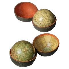
Pair of George III 3 inch pocket globes by J & W Cary, one dated 1791
Located in Lymington, Hampshire
It is housed in a hinged shagreen case closed by a brass hook and lined with a hand-coloured engraved map of the ‘world as known in CÆSAR’s Time agreeable to D’Anville’ and ‘A Table ...
Shagreen
It's hard to resist the allure of a beautiful pool. So, go ahead and daydream about whiling away your summer in paradise.
It’s never too early for good design. These interiors combine elevated furnishings and a youthful spirit, resulting in spaces that are at once elegant and whimsical.
Produced in 1843, the well-preserved volume is evidence of the author's exacting specifications.
New or old, the coverlets add old-time charm to any space.
Get into the games! These items celebrate the events, athletes, host countries and sporting spirit.
French trendsetter and serial collector Daniel Rozensztroch tells us about his obsession with objects related to seafaring men.
The sought-after designer worked with the team at Hoffman Creative to produce a monograph that beautifully showcases some of Studio Shamshiri's most inspiring projects.
Italian writer and collector Umberto Pasti opens the doors to his remarkable cave of wonders in North Africa.