Duval Asia Map 1663 China Japan Korea Great Wall Antique French Cartography
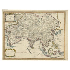
This elegant 17th-century map titled “L’Asie” is a finely executed French representation of the Asian continent by Pierre Duval, one of the foremost cartographers of Louis XIV’s France. Published in Paris in 1663, the map reflects a significant stage in European geographic knowledge, presenting Asia with increasing accuracy at a moment when global exploration, trade, and diplomatic contact were rapidly transforming Western understanding of the East.
Most of the place names shown represent geographical entities that still exist today or once existed historically, giving the map strong continuity between early modern geography and the modern world. Particularly notable is the improved rendering of Japan and the Korean peninsula, both shown with greater accuracy than in earlier 16th-century maps. The lower islands of Japan are better proportioned, and Korea is clearly depicted as a peninsula rather than an island, marking an important correction in European cartography.
China dominates the interior of the continent and is richly detailed with provinces, river systems, and cities. One of the most appealing features is the visible tracing of the Great Wall of China...
Category
Mid-17th Century Antique French Wall Decorations