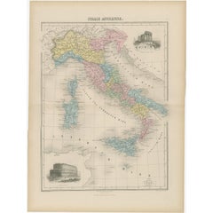
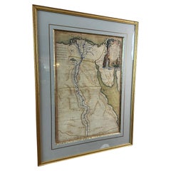
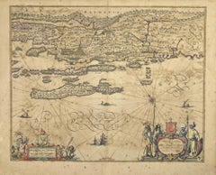
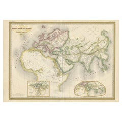
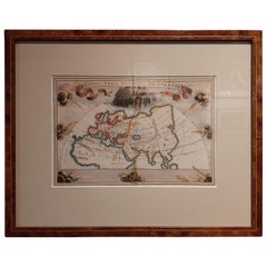
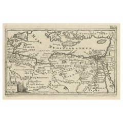
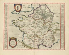
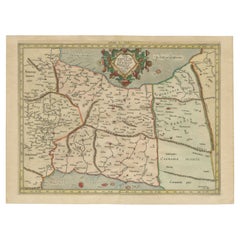
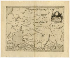
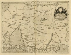
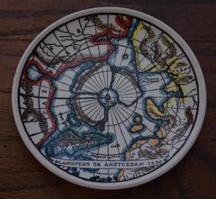
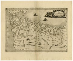
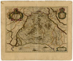
Ancient Maps

to
59
172
13
97
83
49
44
43
26
21
20
17
13
13
11
9
6
6
6
5
4
4
4
4
4
4
3
3
3
3
3
3
2
2
2
2
2
2
1
1
1
1
1
1
1
1
1
1
1
1
1
19
2
2
2
2
Li Governi di Borgogna - Ancient Map - 1777

Li Governi di Borgogna - Ancient Map - 1777

Located in Roma, IT

Projezione. An ancient very detailed map of France, in very good conditions, except for the sign of

Category

1770s Modern Landscape Prints

Materials

Etching

Ancient Map of Africa - Etching - 19th century

Ancient Map of Africa - Etching - 19th century

Located in Roma, IT

This Map of Africa is an etching realized in the 19th century. The state of preservation of the

Category

19th Century More Prints

Materials

Etching

Ancient Map of Guyane - Original Etching - 19th Century

Ancient Map of Guyane - Original Etching - 19th Century

Located in Roma, IT

Map of Guyane is an original etching realized by an anonymous engraver of the 19th Century

Category

19th Century Modern Figurative Prints

Materials

Etching

Hemisphere Of The New Continent - Ancient Map by J.G. Heck - 1834.

Hemisphere Of The New Continent - Ancient Map by J.G. Heck - 1834.

By Johann Georg Heck

Located in Roma, IT

Hemisphere Of The New Continent - West is an artwork realized in 1834 by Johann Georg Heck Original colored print. Good conditions except for yellowing of the paper and very littl...

Category

1830s Modern Figurative Prints

Materials

Etching

Hemisphere Of The New Continent - Ancient Map by J.G. Heck - 1834.

Hemisphere Of The New Continent - Ancient Map by J.G. Heck - 1834.

By Johann Georg Heck

Located in Roma, IT

Hemisphere Of The New Continent is an artwork realized around 1760 by Johann Georg Heck Original colored print. Good conditions except for yellowing of paper and tears along the m...

Category

1830s Modern Figurative Prints

Materials

Etching

Original Antique Map of the Region Between the Gulf of Lybia and the Red Sea

Original Antique Map of the Region Between the Gulf of Lybia and the Red Sea

$404Sale Price / item|20% Off

H 7.56 in W 11.15 in D 0.02 in

Original Antique Map of the Region Between the Gulf of Lybia and the Red Sea

Located in Langweer, NL

Original antique map titled 'Aegyptus et Cyrene'. Detailed ancient map of the region between the

Category

Antique Early 18th Century Maps

Materials

Paper

Antique Map of Ancient Greece – Classical Balkans & Aegean, Engraving c.1818

Antique Map of Ancient Greece – Classical Balkans & Aegean, Engraving c.1818

Located in Langweer, NL

Antique Map of Ancient Greece – Classical Balkans & Aegean, Engraving c.1818 Elegant antique map

Category

Antique Early 19th Century British Maps

Materials

Paper

Steel Engraved Map of Ancient Britain

Steel Engraved Map of Ancient Britain

$115Sale Price|20% Off

H 10.24 in W 8.31 in D 0.02 in

Steel Engraved Map of Ancient Britain

Located in Langweer, NL

Antique map titled 'Angleterre Ancienne'. Original old map of Ancient Britain. Source unknown, to

Category

Antique Late 19th Century Maps

Materials

Paper

Peloponnesus Classical Map — Travels of Anacharsis Greece, Wilkinson c1818

Peloponnesus Classical Map — Travels of Anacharsis Greece, Wilkinson c1818

Located in Langweer, NL

and inspired a series of scholarly maps visualizing the ancient world. Wilkinson’s edition reflects

Category

Antique Early 19th Century British Maps

Materials

Paper

Antique Map of the Ancient Greek Colonization

Antique Map of the Ancient Greek Colonization

$173Sale Price|20% Off

H 11.54 in W 17.33 in D 0.02 in

Antique Map of the Ancient Greek Colonization

Located in Langweer, NL

'. Original antique map of the ancient Greek colonization. Frontispiece map of 'The History of Ancient Greece

Category

Antique Late 18th Century Maps

Materials

Paper

Original Antique Map of Ancient Asia, 1847

Original Antique Map of Ancient Asia, 1847

$253

H 10.63 in W 14.85 in D 0.01 in

Original Antique Map of Ancient Asia, 1847

Located in Langweer, NL

Description: Antique map Asia titled 'Asie Ancienne'. This is an original antique map of Ancient

Category

Antique 1840s French Maps

Materials

Paper

Ancient World Map of Europe, Asia & Northern Africa with Ancient Names, 1725

Ancient World Map of Europe, Asia & Northern Africa with Ancient Names, 1725

$1,129Sale Price|25% Off

H 15.75 in W 18.51 in D 0.01 in

Ancient World Map of Europe, Asia & Northern Africa with Ancient Names, 1725

Located in Langweer, NL

ancient world depicting Europe, Asia, and northern Africa with ancient place names. This map originates

Category

Antique 1720s French Maps

Materials

Paper

Ancient Sarmatia & Eastern Europe Map — Classical Geography, Wilkinson 1801

Ancient Sarmatia & Eastern Europe Map — Classical Geography, Wilkinson 1801

Located in Langweer, NL

Ancient Sarmatia & Eastern Europe Map — Classical Geography, Wilkinson 1801 This elegant hand

Category

Antique Early 19th Century British Maps

Materials

Paper

Ancient Germania Map — Roman Germany & Danube Frontier, Wilkinson 1822

Ancient Germania Map — Roman Germany & Danube Frontier, Wilkinson 1822

Located in Langweer, NL

Ancient Germania Map — Roman Germany & Danube Frontier, Wilkinson 1822 This detailed antique

Category

Antique Early 19th Century British Maps

Materials

Paper

Ancient Macedonia & Thrace Map — Classical Greece, Wilkinson London 1819

Ancient Macedonia & Thrace Map — Classical Greece, Wilkinson London 1819

Located in Langweer, NL

Ancient Macedonia & Thrace Map — Classical Greece, Wilkinson London 1819 This finely engraved

Category

Antique Early 19th Century British Maps

Materials

Paper

Ancient Pannonia & Dacia Map — Roman Balkans Provinces, Wilkinson 1823

Ancient Pannonia & Dacia Map — Roman Balkans Provinces, Wilkinson 1823

Located in Langweer, NL

Ancient Pannonia & Dacia Map — Roman Balkans Provinces, Wilkinson 1823 This finely engraved

Category

Antique Early 19th Century British Maps

Materials

Paper

Ancient Raetia & Noricum Map — Roman Alpine Provinces, Wilkinson 1823

Ancient Raetia & Noricum Map — Roman Alpine Provinces, Wilkinson 1823

Located in Langweer, NL

Ancient Raetia & Noricum Map — Roman Alpine Provinces, Wilkinson 1823 This finely engraved

Category

Antique Early 19th Century British Maps

Materials

Paper

Antique Map of ancient France by Zannoni, 1765

Antique Map of ancient France by Zannoni, 1765

$385

H 15.75 in W 18.9 in D 0 in

Antique Map of ancient France by Zannoni, 1765

Located in Langweer, NL

Antique map France titled 'Galliae Veteris (..)'. Beautiful old map of France. This map originates

Category

Antique 18th Century Maps

Materials

Paper

Ancient World Map: Europe, Africa & Asia - 1802 Tardieu Atlas

Ancient World Map: Europe, Africa & Asia - 1802 Tardieu Atlas

$424Sale Price|20% Off

H 16.3 in W 22.33 in D 0.01 in

Ancient World Map: Europe, Africa & Asia - 1802 Tardieu Atlas

Located in Langweer, NL

knowledge and ancient texts. Map Features: - Continents Displayed: Europe, Northern Africa, and parts of

Category

Antique Early 1800s Maps

Materials

Paper

Ancient Syria & Assyria Map — Biblical Near East, Wilkinson London 1815

Ancient Syria & Assyria Map — Biblical Near East, Wilkinson London 1815

Located in Langweer, NL

Ancient Syria & Assyria Map — Biblical Near East, Wilkinson London 1815 This finely engraved and

Category

Antique Early 19th Century British Maps

Materials

Paper

Ancient Asia Minor Map — Classical Anatolia & Pontus, Wilkinson London 1815

Ancient Asia Minor Map — Classical Anatolia & Pontus, Wilkinson London 1815

Located in Langweer, NL

Ancient Asia Minor Map — Classical Anatolia & Pontus, Wilkinson London 1815 This finely engraved

Category

Antique Early 19th Century British Maps

Materials

Paper

Antique Ancient World Map – Orbis Veteribus Notus, Engraving c.1818

Antique Ancient World Map – Orbis Veteribus Notus, Engraving c.1818

Located in Langweer, NL

Antique Ancient World Map – Orbis Veteribus Notus, Engraving c.1818 Striking antique map depicting

Category

Antique Early 19th Century British Maps

Materials

Paper

Ancient Achaia Map — Travels of Anacharsis Classical Greece, Wilkinson 1818

Ancient Achaia Map — Travels of Anacharsis Classical Greece, Wilkinson 1818

Located in Langweer, NL

Ancient Achaia Map — Travels of Anacharsis Classical Greece, Wilkinson 1818 A finely engraved and

Category

Antique Early 19th Century British Maps

Materials

Paper

Antique Map of Asia Minor & the Levant – Anatolia, Syria & Cyprus, c.1818

Antique Map of Asia Minor & the Levant – Anatolia, Syria & Cyprus, c.1818

Located in Langweer, NL

the atlas A Complete Body of Ancient Geography. Produced during the neoclassical period, the map

Category

Antique Early 19th Century British Maps

Materials

Paper

Original Antique Map of Ancient Greece- Boeotia, Thebes, 1787

Original Antique Map of Ancient Greece- Boeotia, Thebes, 1787

Located in St Annes, Lancashire

Great map of Ancient Greece. Showing the region of Boeotia, including Thebes Drawn by J.D

Category

Antique 1780s French Other Maps

Materials

Paper

Original Antique Map of Ancient Greece, Achaia, Corinth, 1786

Original Antique Map of Ancient Greece, Achaia, Corinth, 1786

Located in St Annes, Lancashire

Great map of Ancient Greece. Showing the region of Thessaly, including Mount Olympus Drawn by

Category

Antique 1780s French Other Maps

Materials

Paper

Antique Map of France in Ancient Roman Times, 1880

Antique Map of France in Ancient Roman Times, 1880

Located in Langweer, NL

Antique map titled 'Gaule indépendante et Romaine'. Old map of Gaul or France in ancient Roman

Category

Antique 19th Century Maps

Materials

Paper

Mercator's Ptolemaic Map of Ancient Assyria, Media, and Persia

Mercator's Ptolemaic Map of Ancient Assyria, Media, and Persia

$1,099Sale Price|20% Off

H 15.36 in W 20.87 in D 0 in

Mercator's Ptolemaic Map of Ancient Assyria, Media, and Persia

Located in Langweer, NL

This map, "Asiae I Tab:", features the region corresponding to modern-day Iran and Iraq

Category

Antique 16th Century Maps

Materials

Paper

Ancient Europe Map 1652, Europa Antiqua – Nicolas Blancardus, Roman World

Ancient Europe Map 1652, Europa Antiqua – Nicolas Blancardus, Roman World

Located in Langweer, NL

Ancient Europe Map 1652, Europa Antiqua – Nicolas Blancardus, Roman World Description: This

Category

Antique Mid-17th Century Dutch Maps

Materials

Paper

Antique Holy Land Map, Terrae Sanctae Tabula – Guillaume De L’Isle, 1782

Antique Holy Land Map, Terrae Sanctae Tabula – Guillaume De L’Isle, 1782

Located in Langweer, NL

, Palestine map, Israel antique map, Jerusalem cartography, Damascus Sidon map, Dead Sea ancient map

Category

Antique Late 18th Century French Maps

Materials

Paper

Cairo, Babylon & Heliopolis – Antique Map of Ancient Memphis Region, 1776

Cairo, Babylon & Heliopolis – Antique Map of Ancient Memphis Region, 1776

Located in Langweer, NL

Cairo, Babylon & Heliopolis – Antique Map of Ancient Memphis Region, 1776 This antique map is an

Category

Antique Late 18th Century Dutch Maps

Materials

Paper

1710 Edward Wells Detailed Ancient Greece Map with Ornate Cartouche

1710 Edward Wells Detailed Ancient Greece Map with Ornate Cartouche

$742Sale Price|20% Off

H 17.92 in W 23.23 in D 0 in

1710 Edward Wells Detailed Ancient Greece Map with Ornate Cartouche

Located in Langweer, NL

"1710 Edward Wells Map of Ancient Greece: A New Map of Antient Greece, Tirana, Morea, Ilyricum

Category

Antique 1710s Maps

Materials

Paper

Map of Europe Highlighting Ancient and Modern Geographical Divisions (1794)

Map of Europe Highlighting Ancient and Modern Geographical Divisions (1794)

$1,425Sale Price|30% Off

H 28.75 in W 21.38 in D 0.01 in

Map of Europe Highlighting Ancient and Modern Geographical Divisions (1794)

Located in Langweer, NL

Map of Europe Highlighting Ancient and Modern Geographical Divisions (1794). Germany, France, Italy

Category

Antique 1790s French Maps

Materials

Paper

Antique Map of Ancient Italy – Roman Peninsula & Sicily, Engraving c.1818

Antique Map of Ancient Italy – Roman Peninsula & Sicily, Engraving c.1818

Located in Langweer, NL

Antique Map of Ancient Italy – Roman Peninsula & Sicily, Engraving c.1818 Elegant antique map

Category

Antique Early 19th Century British Maps

Materials

Paper

Ancient Iberia: Hispania Map from Spruner-Menke Atlas Antiquus, 1880

Ancient Iberia: Hispania Map from Spruner-Menke Atlas Antiquus, 1880

$356Sale Price|20% Off

H 15.56 in W 18.51 in D 0 in

Ancient Iberia: Hispania Map from Spruner-Menke Atlas Antiquus, 1880

Located in Langweer, NL

This map is titled "HISPANIA," indicating it is a historical map of ancient Spain. It is an

Category

Antique 1880s Maps

Materials

Paper

Antique Map of Ancient Britain – Roman England, Wales & Scotland, c.1818

Antique Map of Ancient Britain – Roman England, Wales & Scotland, c.1818

Located in Langweer, NL

Antique Map of Ancient Britain – Roman England, Wales & Scotland, c.1818 Elegant antique map

Category

Antique Early 19th Century British Maps

Materials

Paper

Aegyptus Antiqua — Ancient Egypt Classical Map of the Nile, Wilkinson 1823

Aegyptus Antiqua — Ancient Egypt Classical Map of the Nile, Wilkinson 1823

Located in Langweer, NL

Aegyptus Antiqua — Ancient Egypt Classical Map of the Nile, Wilkinson 1823 This finely engraved

Category

Antique Early 19th Century British Maps

Materials

Paper

Antique Map of Westfriesland in Ancient Times by Alting, 1697

Antique Map of Westfriesland in Ancient Times by Alting, 1697

Located in Langweer, NL

Westfriesland in ancient times. This copper engraved map shows part of Holland as it was in ancient times. It

Category

Antique 17th Century Maps

Materials

Paper

Original Hand-Colored Antique Map of Ancient Germany, circa 1630

Original Hand-Colored Antique Map of Ancient Germany, circa 1630

$809Sale Price|20% Off

H 18.9 in W 21.5 in D 0.02 in

Original Hand-Colored Antique Map of Ancient Germany, circa 1630

Located in Langweer, NL

Antique map titled 'Germaniae Veteris typus'. Very attractive map of ancient Germany. Published by

Category

Antique Mid-17th Century Maps

Materials

Paper

Antique Map of Edom, an Ancient Kingdom in Transjordan, 1773

Antique Map of Edom, an Ancient Kingdom in Transjordan, 1773

Located in Langweer, NL

Antique print titled 'Idumea, of thet Land der Philistynen'. Old map of Edom, an ancient kingdom in

Category

Antique 18th Century Maps

Materials

Paper

Hand-Colored Antique Map of Ancient Gaul, Roman Provinces, Circa 1748

Hand-Colored Antique Map of Ancient Gaul, Roman Provinces, Circa 1748

Located in Langweer, NL

Title: FRANCE – Ancient Gaul, Roman Provinces and Tribal Regions, Hand-Colored Map c.1748

Category

Antique Mid-18th Century British Maps

Materials

Paper

Antique Map of Italy and Corse in Ancient Times, 1848

Antique Map of Italy and Corse in Ancient Times, 1848

Located in Langweer, NL

Antique map titled 'Italia Superior et Corsica'. Old map of northern Italy and Corse

Category

Antique 19th Century Maps

Materials

Paper

Antique Hand-Coloured Miniature Map of Ancient Europe, c.1685

Antique Hand-Coloured Miniature Map of Ancient Europe, c.1685

Located in Langweer, NL

Antique map of Europe titled 'Europe Ancienne, Das alte Europa'. Hand-coloured miniature map with

Category

Antique 17th Century Maps

Materials

Paper

17th Century Framed Map of Ancient France Titled "Typus Galliae Veteris"

17th Century Framed Map of Ancient France Titled "Typus Galliae Veteris"

Located in Dallas, TX

Decorate an office or a library with this elegant historic map. Crafted in the Netherlands circa

Category

Antique 17th Century Dutch Baroque Maps

Materials

Glass, Giltwood, Paper

  • 1

Recent Sales

Framed French Color Engraving of a 1575 Ancient Map of Paris

Framed French Color Engraving of a 1575 Ancient Map of Paris

Unavailable

H 15.5 in W 19.5 in D 0.01 in

Framed French Color Engraving of a 1575 Ancient Map of Paris

Located in Petaluma, CA

This is a lovely framed French color engraving is of a 1575 ancient map of Paris (Lutetia

Category

Late 20th Century French Prints

Materials

Paper

Antique Rand McNally & Company Schoolmap. Ancient Oriental Empires. Historical

Antique Rand McNally & Company Schoolmap. Ancient Oriental Empires. Historical

By Rand McNally & Co.

Located in ROTTERDAM, ZH

made in the late 1920's. The map of all the Ancient Oriental Empires shows the world as it was ruled

Category

Vintage 1920s American American Classical Maps

Materials

Fabric, Paper

Vintage Fornasetti "Antichi Planisferi" Coasters

Vintage Fornasetti "Antichi Planisferi" Coasters

By Fornasetti

Located in Princeton, NJ

featuring ancient maps. Made in Italy by Piero Fornasetti and signed to reverse. Original orange box

Category

Vintage 1960s Italian Mid-Century Modern Porcelain

Materials

Porcelain

"Graecia Antiqua" (Ancient Greece Map)

"Graecia Antiqua" (Ancient Greece Map), 1870

Unavailable

H 15 in W 12.75 in D 0.63 in

"Graecia Antiqua" (Ancient Greece Map)

Located in New York, NY

Original 1870 map of Ancient Greece from Chambers's Encyclopædia. Presented in a new gold wood

Category

1870s Realist Landscape Prints

Materials

Lithograph

Territori Hand-Knotted Bamboo Silk Rug

Territori Hand-Knotted Bamboo Silk Rug

Unavailable

W 118.12 in L 98.43 in

Territori Hand-Knotted Bamboo Silk Rug

By Studio Zero

Located in Como, CO

As in an ancient map that depicts lost lands, reliefs and depressions, on this carpet they follow

Category

2010s Indian Modern Western European Rugs

Materials

Silk

1784 Map of Egypt
1784 Map of Egypt

1784 Map of Egypt

Located in New York, NY

1784 D'Anville map of Ancient Egypt, full title: "AEgyptus Antiqua. Mandato Serenissimi Delphini

Category

1780s Realist Landscape Prints

Materials

Engraving

Four Fold Screen
Four Fold Screen

Four Fold Screen

Unavailable

H 59.06 in W 78.75 in D 0.99 in

Four Fold Screen

Located in Alicante, ES

Orbis Terrarum Descriptio Duobuis Planis Hemisphaeriis Comprehesa. Great quality map of the ancient

Category

Vintage 1960s Screens and Room Dividers

Ducatus Gelriae pars prima quae est Neomagensis.

Ducatus Gelriae pars prima quae est Neomagensis.

By Johannes Janssonius

Located in Zeeland, Noord-Brabant

in 33 maps), and of the Ancient World (60 maps). The eleventh volume was the Atlas of the Heavens by

Category

Mid-17th Century More Prints

Materials

Engraving, Etching

De oude Wereldt tot beter verstandt der oude geschiedenissen.

De oude Wereldt tot beter verstandt der oude geschiedenissen.

By Jacob Keyser

Located in Zeeland, Noord-Brabant

, for a better understanding of ancient history. This map shows Europe, North Africa, and the Middle

Category

Early 18th Century More Prints

Materials

Engraving, Etching

Trasisalania vulgo Overyssel.

Trasisalania vulgo Overyssel., 1646

Unavailable

H 19.53 in W 23 in

Trasisalania vulgo Overyssel.

Located in Zeeland, Noord-Brabant

cities of the world" (Townatlas), of the waterworld (Atlas Maritimus in 33 maps), and of the Ancient

Category

Mid-17th Century More Prints

Materials

Engraving, Etching

Denderah (Tentyris) Plan des Ruines

Denderah (Tentyris) Plan des Ruines

Located in New York, NY

right. Represented is an overview map of the ancient site of the Egyptian temples and the walled

Category

Early 19th Century Realist Landscape Prints

Materials

Engraving

1968 Ancient World School Map

1968 Ancient World School Map

Sold

H 48 in W 3 in D 3.5 in

1968 Ancient World School Map

Located in Tarrytown, NY

Pull down school map of the ancient world made, in Chicago in the 1960s.

Category

Vintage 1960s Maps

Materials

Paper

Antique Map of Ancient Italy and the Islands Corsica, Sicily and Sardinia

Antique Map of Ancient Italy and the Islands Corsica, Sicily and Sardinia

Located in Langweer, NL

Antique map titled 'Italia Antiqua of Oud Italje (..)'. Very decorative map of ancient Italy and

Category

Antique Early 18th Century Maps

Materials

Paper

Antique Map of Ancient Italy with Inset of the Colosseum in Rome, 1880

Antique Map of Ancient Italy with Inset of the Colosseum in Rome, 1880

Located in Langweer, NL

Antique map titled 'Italie Ancienne'. Old map of ancient Italy. With decorative vignettes of the

Category

Antique 19th Century Maps

Materials

Paper

Rare 17th Century American Map of Virginia and Florida by Jan Janssonius

Rare 17th Century American Map of Virginia and Florida by Jan Janssonius

By Jan Johansson

Located in Wiscasset, ME

cities of the world" (Townatlas), of the waterworld (Atlas Maritimus in 33 maps), and of the Ancient

Category

Antique 18th Century and Earlier Dutch Rococo Maps

Piero Fornasetti Rosenthal Temi E Variazioni 'Themes & Variations' Plate

Piero Fornasetti Rosenthal Temi E Variazioni 'Themes & Variations' Plate

By Piero Fornasetti

Located in Downingtown, PA

the face of Lina Cavalieri overlaid with an ancient map. This is a rare example from this series

Category

Vintage 1980s Mid-Century Modern Porcelain

Materials

Porcelain

Topographical Survey Ceramic Wall Sculpture

Topographical Survey Ceramic Wall Sculpture

Sold

H 18 in W 1.75 in L 18 in

Topographical Survey Ceramic Wall Sculpture

Located in Los Angeles, CA

artist conjured up with his mind rather than referring to ancient maps. This snapshot of a real or

Category

Mid-20th Century American Modern Wall-mounted Sculptures

Materials

Walnut, Ceramic

Antique Persian Sultanabad Oriental Rug

Antique Persian Sultanabad Oriental Rug

Located in New York, NY

Visions of ancient maps and spirited adventures come to mind when gazing upon the gorgeous patterns

Category

Early 20th Century Persian Sultanabad Persian Rugs

Materials

Wool

Very Large Antique Brass and Mahogany Atlas Coffee Table

Very Large Antique Brass and Mahogany Atlas Coffee Table

Located in London, GB

edge which holds in a glass top over an ancient map of the world. The map is typical of the way the

Category

Vintage 1950s English Coffee and Cocktail Tables

Materials

Brass

17th century Ancient and Modern Egyptian Map, 1762s

17th century Ancient and Modern Egyptian Map, 1762s

Sold

H 23.23 in W 21.26 in D 0.79 in

17th century Ancient and Modern Egyptian Map, 1762s

Located in LEGNY, FR

Very beautiful map of ancient and modern Egypt in French dating from 1762 very well framed by a

Category

Antique 1660s French Posters

Materials

Paper

Italian Art Deco Desk, 1930s

Italian Art Deco Desk, 1930s

Sold

H 31.5 in W 55.91 in D 31.5 in

Italian Art Deco Desk, 1930s

Located in Montelabbate, PU

thirties. On the work surface the subject is in color and reproduces the detail of an ancient map depicting

Category

Vintage 1930s Italian Art Deco Desks and Writing Tables

Materials

Chestnut, Burl

French topographic embossed map in three dimensions of ancient Jerusalem - 19th

French topographic embossed map in three dimensions of ancient Jerusalem - 19th

Located in Bruxelles, BE

French topographic embossed map in three dimensions of Ancient Jerusalem 19th century wood and hand

Category

Antique 19th Century French Belle Époque Models and Miniatures

Materials

Plaster, Wood

1960s Large Italian World Map Globe Bar Cart or Drinks Trolley with Zodiac Signs

1960s Large Italian World Map Globe Bar Cart or Drinks Trolley with Zodiac Signs

Located in London, England

ancient world map with different colours for each country. The sphere world globe rotates around its

Category

Vintage 1960s Italian Mid-Century Modern Carts and Bar Carts

Materials

Walnut

Lost Cities
Lost Cities

Heidi WhitmanLost Cities, 2014

Sold

H 27 in W 36.5 in D 3 in

Lost Cities

By Heidi Whitman

Located in Riverdale, NY

. Contemporary city grids and maps of ancient ruins are primary references. Whitman’s work was featured in

Category

21st Century and Contemporary Contemporary Mixed Media

Materials

Acrylic, Gouache, Ink, Paper

Piero Fornasetti Ceramic Coaster Plates Antichi Planisferi-Ancient Maps

Piero Fornasetti Ceramic Coaster Plates Antichi Planisferi-Ancient Maps

By Piero Fornasetti

Located in Downingtown, PA

Fornasetti complete set of eight barware coaster depicting different ancient maps. The maps include

Category

Mid-20th Century Italian Mid-Century Modern Barware

Materials

Ceramic

1940s Desk in Oak and Brass with an Ancient Map of Paris and Suburb in Front

1940s Desk in Oak and Brass with an Ancient Map of Paris and Suburb in Front

By Paul Dupré-Lafon

Located in Paris, FR

Interesting 1940s desk in varnished oak veneer with an ancient plan of Ile de France in the front

Category

Vintage 1940s French Desks and Writing Tables

Materials

Brass

Antique Map of the Ancient World 'c.1860'

Antique Map of the Ancient World 'c.1860'

Sold

H 24.02 in W 33.08 in D 0.02 in

Antique Map of the Ancient World 'c.1860'

Located in Langweer, NL

Antique map titled 'Monde connu des Anciens'. Large, original antique map of the Ancient World

Category

Antique Mid-19th Century Maps

Materials

Paper

Original Antique Map of Ancient Greece, Messenia, 1786

Original Antique Map of Ancient Greece, Messenia, 1786

Located in St Annes, Lancashire

Great map of Ancient Greece. Showing the region of Messenia Drawn by J.D. Barbie Du Bocage Copper

Category

Antique 1780s French Other Maps

Materials

Paper

Antique Map of the Ancient World by Lapie, 1842

Antique Map of the Ancient World by Lapie, 1842

Sold

H 19.89 in W 26.78 in D 0.02 in

Antique Map of the Ancient World by Lapie, 1842

Located in Langweer, NL

Antique map titled 'Carte du Monde Connu des Anciens'. Map of the Ancient World. This map

Category

Antique Mid-19th Century Maps

Materials

Paper

Original Antique Map of Ancient Greece Attica, Athens, 1785

Original Antique Map of Ancient Greece Attica, Athens, 1785

Located in St Annes, Lancashire

Great map of Ancient Greece. Showing the region of Attica and Athens Drawn by J.D. Barbie Du

Category

Antique 1780s French Other Maps

Materials

Paper

Antique Map of the Ancient World by Cellarius, 1703

Antique Map of the Ancient World by Cellarius, 1703

Located in Langweer, NL

Antique map titled 'Veteris Orbis Climata ex Strabone'. Interesting map of the ancient world

Category

Antique Early 18th Century Maps

Materials

Paper

Original Antique Map of Ancient Greece, Thessaly, Mount Olympus, 1788

Original Antique Map of Ancient Greece, Thessaly, Mount Olympus, 1788

Located in St Annes, Lancashire

Great map of Ancient Greece. Showing the region of Thessaly, including Mount Olympus Drawn by

Category

Antique 1780s French Other Maps

Materials

Paper

Original Antique Map of Ancient Greece, Acarnania & Aetolia, Ithaca, 1785

Original Antique Map of Ancient Greece, Acarnania & Aetolia, Ithaca, 1785

Located in St Annes, Lancashire

Great map of Ancient Greece. Showing the region of Acanania and Aetolia including the islands of

Category

Antique 1780s French Other Maps

Materials

Paper

Antique Map of the Ancient World by A & C. Black, 1870

Antique Map of the Ancient World by A & C. Black, 1870

Located in Langweer, NL

Antique map titled 'Map of the Principal Countries of the Ancient World'. Original antique map of

Category

Antique Late 19th Century Maps

Materials

Paper

Get Updated with New Arrivals
Save "Ancient Maps", and we’ll notify you when there are new listings in this category.

Ancient Maps For Sale on 1stDibs

An assortment of ancient maps is available at 1stDibs. The range of distinct ancient maps — often made from paper, brass and metal — can elevate any home. There are all kinds of ancient maps available, from those produced as long ago as the 18th Century to those made as recently as the 20th Century. There have been many well-made ancient maps over the years, but those made by Johann Georg Heck, Alessandro Moschetti and Karl Spruner von Merz are often thought to be among the most beautiful.

How Much are Ancient Maps?

The average selling price for at 1stDibs is $298, while they’re typically $67 on the low end and $9,198 highest priced.