Items Similar to Antique Map of the Ancient Greek Colonization


Want more images or videos?
Request additional images or videos from the seller
1 of 7
Antique Map of the Ancient Greek Colonization
About the Item
Antique map titled 'Map I containing the Western Division of the Grecian Colonies & Conquests'. Original antique map of the ancient Greek colonization. Frontispiece map of 'The History of Ancient Greece, Its Colonies, and Conquests
From the Earliest Accounts Till the Division of the Macedonian Empire in the East : Including the History of Literature, Philosophy, and the Fine Arts' by John Gillies. Published 1792.
- Dimensions:Height: 11.54 in (29.3 cm)Width: 17.33 in (44 cm)Depth: 0.02 in (0.5 mm)
- Materials and Techniques:
- Period:
- Date of Manufacture:1792
- Condition:Age-related toning. Original folding lines. Some defects in margins. Shows some wear and foxing. Tape on verso, no text. Please study image carefully.
- Seller Location:Langweer, NL
- Reference Number:
About the Seller
5.0
Platinum Seller
These expertly vetted sellers are 1stDibs' most experienced sellers and are rated highest by our customers.
Established in 2009
1stDibs seller since 2017
1,916 sales on 1stDibs
Typical response time: <1 hour
- ShippingRetrieving quote...Ships From: Langweer, Netherlands
- Return PolicyA return for this item may be initiated within 14 days of delivery.
More From This SellerView All
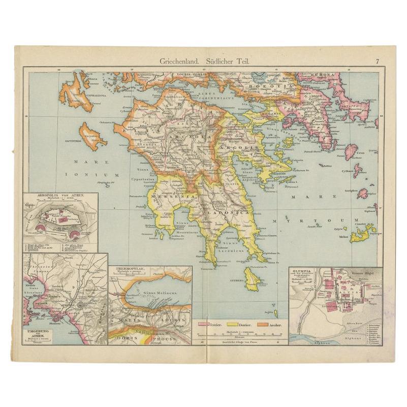
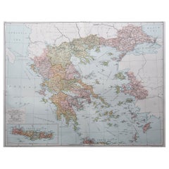
- Antique Map of Southern Greece, 1892Located in Langweer, NLAntique map of Greece titled 'Griechenland. Südlicher Theil'. Old map of Southern Greece with inset maps of the Acropolis of Athens, the region of Athens, Thermopylae and Olympia. So...Category
Antique 19th Century Maps
MaterialsPaper
- Antique Map of Greece with an Inset Map of the Upper Danube Region, c.1720Located in Langweer, NLAntique map titled 'Fluviorum in Europa principis Danubii cum adiacentibus Regnis.' Detailed map of Greece, the Balkans and contiguous parts of the Adriatic and Aegean Seas. The ma...Category
Antique 18th Century Maps
MaterialsPaper
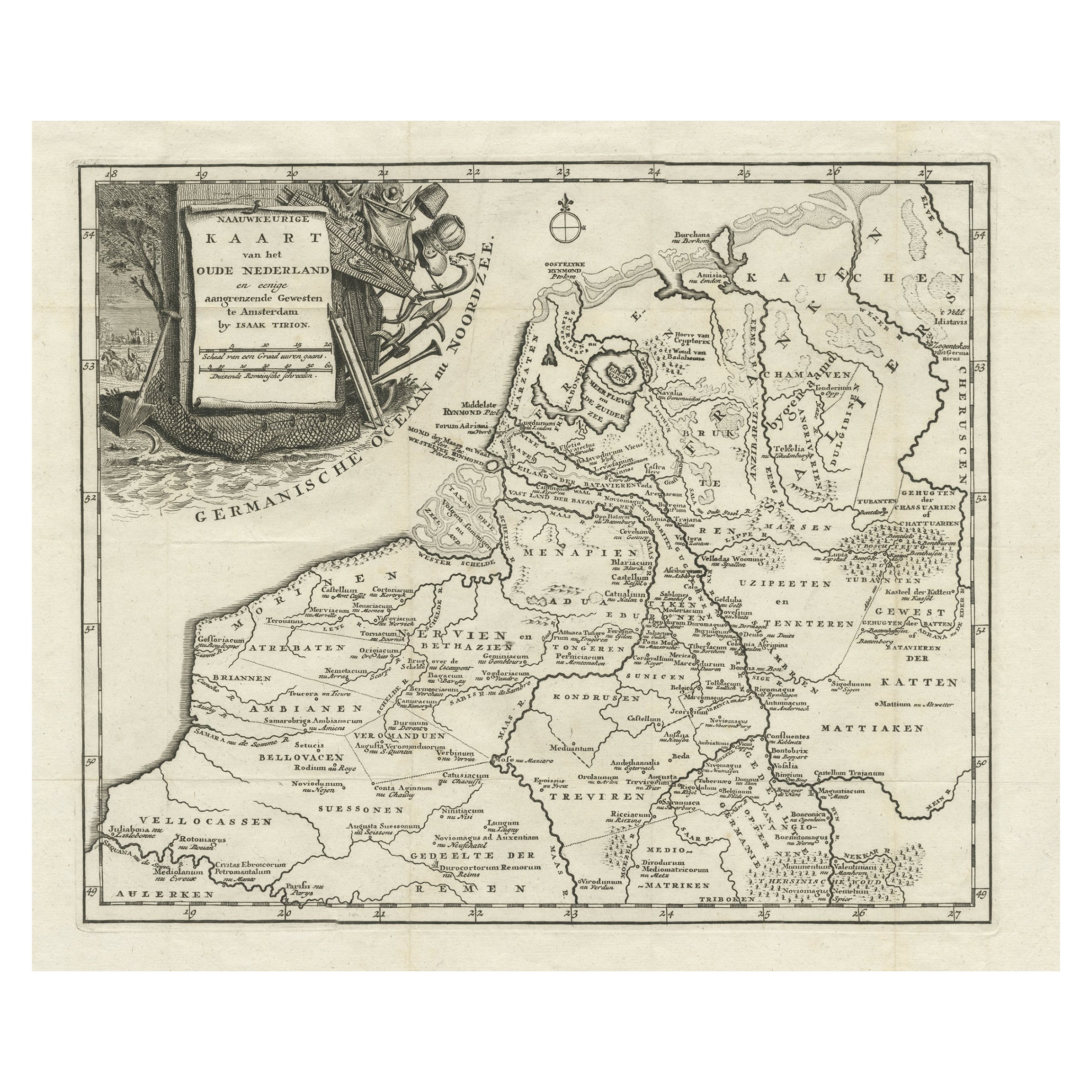
- Original Antique Map of the Ancient Netherlands and Belgium, c.1750Located in Langweer, NLDescription: Antique map titled 'Naauwkeurige Kaart van het Oude Nederland (..)'. Original antique map of the Netherlands and Belgium. This map originates from 'Vaderlandsche his...Category
Antique 1750s Maps
MaterialsPaper
- Antique Map of Ancient Jerusalem, depicting The Temple of Solomon, c.1725Located in Langweer, NLAntique map titled 'Nieuwe Plattegrond van het Oude Jeruzalem Volgens den Schryver.' Bird's-eye view of the ancient city of Jerusalem shows its divisions with prominent depiction...Category
Antique 18th Century Maps
MaterialsPaper
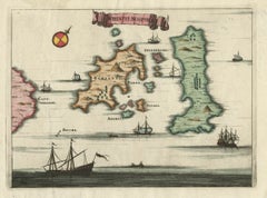
- Antique Map of the Islands of Schiatti and Scopoli, Greece, 1687Located in Langweer, NLAntique map titled 'Schiatti - Scopoli.' This original antique map shows the islands Schiatti and Scopoli in Greece. Source unknown, to be determined. Artists and Engravers: Made by...Category
Antique 17th Century Maps
MaterialsPaper
- Original Antique Map of Ancient Asia, 1847Located in Langweer, NLDescription: Antique map Asia titled 'Asie Ancienne'. This is an original antique map of Ancient Asia and originates from 'Atlas de la Geographie ...Category
Antique 1840s Maps
MaterialsPaper


You May Also Like
- Original Antique Map of Ancient Greece, Achaia, Corinth, 1786Located in St Annes, LancashireGreat map of Ancient Greece. Showing the region of Thessaly, including Mount Olympus Drawn by J.D. Barbie Du Bocage Copper plate engraving by P.F Tardieu Original hand color...Category
Antique 1780s French Other Maps
MaterialsPaper
- Original Antique Map of Ancient Greece- Boeotia, Thebes, 1787Located in St Annes, LancashireGreat map of Ancient Greece. Showing the region of Boeotia, including Thebes Drawn by J.D. Barbie Du Bocage Copper plate engraving by P.F T...Category
Antique 1780s French Other Maps
MaterialsPaper
- Original Antique Map of Ancient Greece, Phocis, Gulf of Corinth, 1787Located in St Annes, LancashireGreat map of Ancient Greece. Showing the region of Phocis, including the Gulf of Corinth Drawn by J.D. Barbie Du Bocage Copper plate engraving by P.F Tardieu Original hand c...Category
Antique 1780s French Other Maps
MaterialsPaper
- 1861 Topographical Map of the District of Columbia, by Boschke, Antique MapLocated in Colorado Springs, COPresented is an original map of Albert Boschke's extremely sought-after "Topographical Map of the District of Columbia Surveyed in the Years 1856 ...Category
Antique 1860s American Historical Memorabilia
MaterialsPaper
- Large Original Vintage Map of Greece, circa 1920Located in St Annes, LancashireGreat map of Greece Original color. Good condition Published by Alexander Gross Unframed.Category
Vintage 1920s English Maps
MaterialsPaper
- Hand-Colored 18th Century Homann Map of the Danube, Italy, Greece, CroatiaBy Johann Baptist HomannLocated in Alamo, CA"Fluviorum in Europa principis Danubii" is a hand colored map of the region about the Danube river created by Johann Baptist Homann (1663-1724) in his 'Atlas Novus Terrarum', publish...Category
Antique Early 18th Century German Maps
MaterialsPaper


Recently Viewed
View AllMore Ways To Browse
Map Of German
Keith Johnston
1500 Map
Magellan Map
Chinese Plague
Antique Map Mexico City
Tartar Map
Antique Maps Of Kansas
Nova Scotia Map
Map Of Kentucky
Vintage Road Maps Collectables
Cornelius And Company
Pirate Map
Knoop Pomologia
Antique Map Delaware
David Kleyne
Furniture From Portugal Antique
Vintage Maps Of England