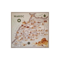
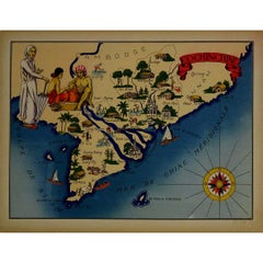
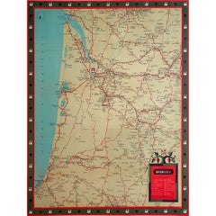
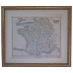
illustrated map of Morocco created in 1950 by Delaye
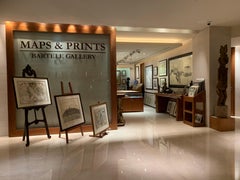
Located in PARIS, FR
Beautiful illustrated map of Morocco created in 1950 by Delaye.
Category
1950s Prints and Multiples
Materials
Paper, Lithograph
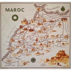
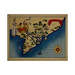
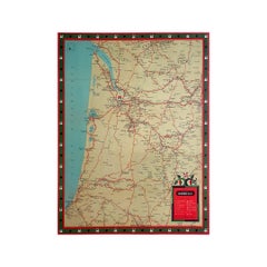
illustrated map of Morocco created in 1950 by Delaye
Located in PARIS, FR
Beautiful illustrated map of Morocco created in 1950 by Delaye.
Paper, Lithograph
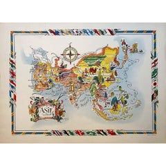
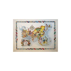
Jacques Liozu's 1951 illustrated map of Asia
By Jacques Liozu
Located in PARIS, FR
Jacques Liozu's 1951 illustrated map of Asia is an exceptional work of cartography that combines art and geography to offer a captivating vision of this vast continent.
Paper, Lithograph
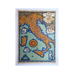
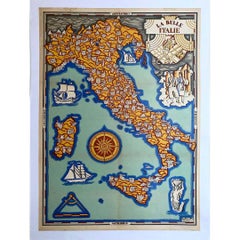
Illustrated map of Italy by Umberto Zimelli dating from 1933
Located in PARIS, FR
Very nice illustrated map of Italy dating from 1933. Italy - Tourism
Linen, Paper, Lithograph
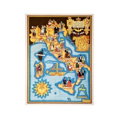
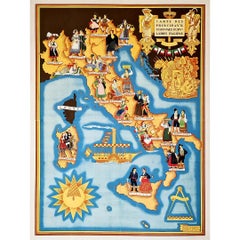
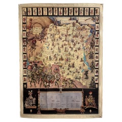
Illustrated map from 1934 of the main Italian popular costumes - Old map
Located in PARIS, FR
Very beautiful illustrated map from 1934 of the main Italian popular costumes.
Linen, Paper, Lithograph

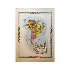
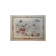
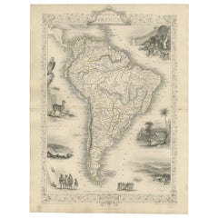
Jacques Liozu's 1951 illustrated map of South America
By Jacques Liozu
Located in PARIS, FR
Jacques Liozu's 1951 illustrated map of South America is an exceptional work of cartography that skilfully blends art and geography.
Paper, Lithograph
1943 original illustrated map of Cochinchine by Dylbert
Located in PARIS, FR
Dylbert’s map exemplifies mid-20th-century illustrated cartography, a style where maps were not only functional but also aesthetic.
Linen, Paper, Lithograph
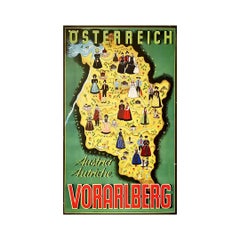
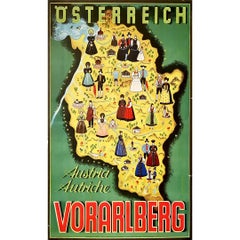
Original poster of Thurnher Weiss representing an illustrated map of Vorarlberg
Located in PARIS, FR
Original poster of Thurnher Weiss representing an illustrated map of Vorarlberg which is a region of Austria.
Paper, Lithograph
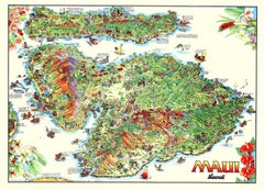
Maui, Hawaii — Kim Forrest, 1992 Illustrated Map Poster, Offset Lithograph
Located in Spokane, WA
Titled Maui, Hawaii, and created in 1992, this illustrated map by Kim Forrest presents the island through a lively, highly detailed visual language that merges cartography with story...
Offset

Circa 1950 original illustrated map "Carte des Montagnes Suisses"
Located in PARIS, FR
The circa 1950 original illustrated map "Carte des Montagnes Suisses" by L.
Linen, Paper, Lithograph
Circa 1950 original illustrated map for "Carte France autour de Bordeaux"
Located in PARIS, FR
Illustrated document Tourism - Bordeaux - Map
Linen, Paper
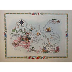
Jacques Liozu's 1951 illustrated map of Australia and Oceania
By Jacques Liozu
Located in PARIS, FR
Jacques Liozu's 1951 illustrated map of Australia and Oceania is a remarkable cartographic work that combines art and geography to offer an enchanting representation of this part of ...
Paper, Lithograph
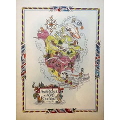
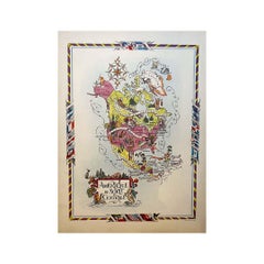
Jacques Liozu's 1951 illustrated map of North and Central America
By Jacques Liozu
Located in PARIS, FR
Jacques Liozu's 1951 illustrated map of North and Central America is an exceptional work of cartography that combines geographical precision with artistic aesthetics.
Paper, Lithograph
$315Sale Price|20% Off
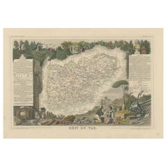
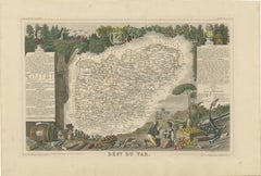
The Illustrated Map of the Var Department from the Atlas National Illustré, 1856
Located in Langweer, NL
This original hand-colored map is from the "Atlas National Illustré," a work by Victor Levasseur, a French geographer and cartographer known for his richly illustrated maps.
Paper
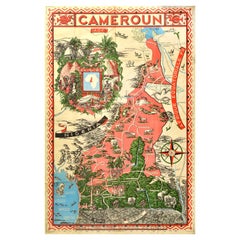

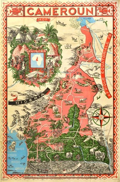
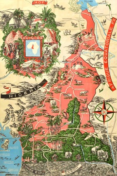
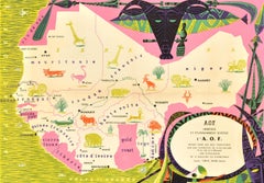
Original Vintage Illustrated Map Poster Afrique Equatoriale Francaise Cameroon
Located in London, GB
Original vintage illustrated map poster for Cameroun AOF Afrique Occidentale Francaise / Cameroon French West Africa showing the Central African country of Cameroon in pink and green...
Paper
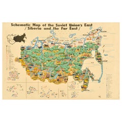

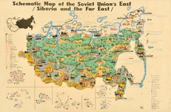
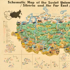
Original Vintage Illustrated Map Poster Schematic Map Soviet Union USSR Russia
Located in London, GB
Original vintage illustrated map poster - Schematic Map of the Soviet Union's East Siberia and the Far East - featuring forests, rivers, mountains, cattle and other animals, shipping...
Paper
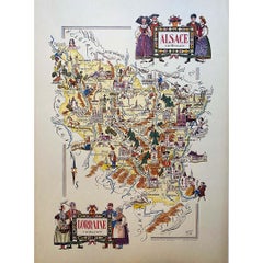
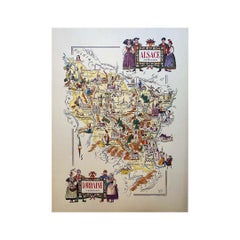
Jacques Liozu's 1951 illustrated map of Alsace and Lorraine in France
By Jacques Liozu
Located in PARIS, FR
Jacques Liozu's 1951 illustrated map of Alsace and Lorraine is a remarkable work of cartography that blends art and geography to offer a poetic and moving vision of these emblematic ...
Paper, Lithograph
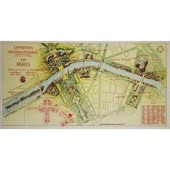
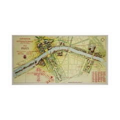
1937 original poster illustrated map of the Exposition Internationale
Located in PARIS, FR
This 1937 original poster presents a detailed illustrated map of the Exposition Internationale des Arts et Techniques dans la Vie Moderne, held in Paris.
Paper, Lithograph, Linen
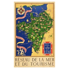

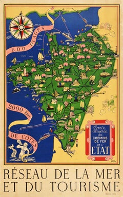
Original Vintage Illustrated Map Poster Railway Travel Normandy Brittany Paris
By Lucien Boucher
Located in London, GB
Original vintage travel poster featuring a colourful Illustrated Map of the State Railways Sea and Tourism Network / Carte Illustre des Chemins de Fer de l'Etat Reseau de la Mer et d...
Paper
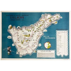
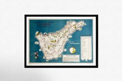
An original poster featuring an illustrated map of Tenerife - La Lucha
Located in PARIS, FR
A beautiful poster featuring an illustrated map of Tenerife or Tenerife, an island in Spain that forms part of the Canary Islands archipelago in the Atlantic Ocean.
Paper, Lithograph
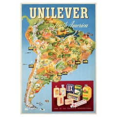

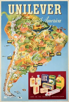
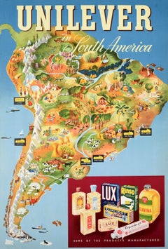
Original Vintage Advertising Poster Unilever South America Illustrated Map Art
Located in London, GB
Original vintage advertising poster for Unilever in South America featuring a colourful illustrated map marking the factories - Lever & Atkinson Lima Peru / Atkinson Santiago Chile /...
Paper
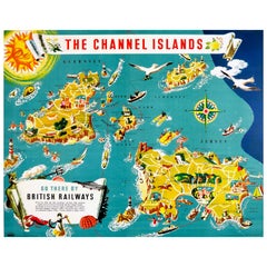
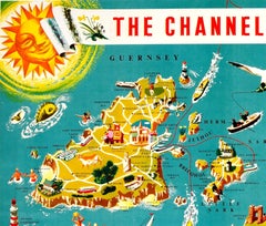
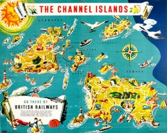
Original Vintage British Railways Poster Illustrated Map of the Channel Islands
Located in London, GB
Original vintage travel advertising poster for The Channel Islands - Go there by British Railways published by the Southern Region of British Railways. Colourful illustrated map of t...
Paper
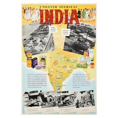
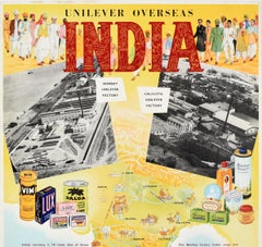
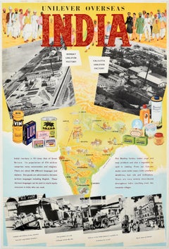
Original Vintage Advertising Poster Unilever Overseas India Illustrated Map
Located in London, GB
Original vintage advertising poster for Unilever Overseas India. Great illustrated map of India showing the industry production for Unilever with images including a tiger in a jungle...
Paper
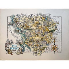
Jacques Liozu's 1951 illustrated map of the region of Pays d'Ouest
By Jacques Liozu
Located in PARIS, FR
Jacques Liozu's 1951 illustrated map of the Pays d'Ouest is a remarkable cartographic work that skilfully combines art and geography.
Paper, Lithograph
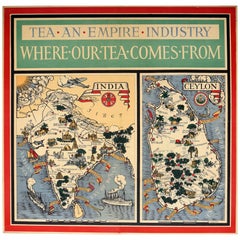
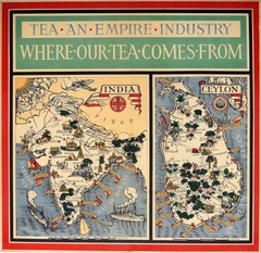
Original Vintage Illustrated Map Poster Empire Industry Where Our Tea Comes From
Located in London, GB
Rare small version depicting colourful illustrated maps of India and Ceylon (now Sri Lanka) featuring the city names in decorative banners as well as images of people, historical pla...
Paper
$638
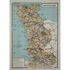
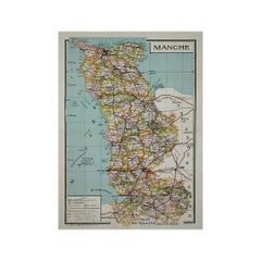
Circa 1950 original illustrated map by André Lesot for "Carte de la Manche"
Located in PARIS, FR
The circa 1950 original illustrated map by André Lesot for "Carte de la Manche" is a significant piece that highlights both artistic design and geographic representation.
Linen, Paper, Lithograph
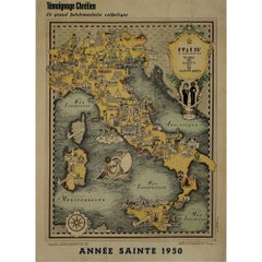
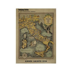
1950 illustrated map Italy, Land of Saints and Sanctuaries
Located in PARIS, FR
Churches, monasteries, and cathedrals populate the map, illustrating Italy’s deep religious heritage.
Linen, Paper, Lithograph
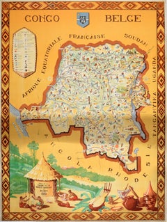
Colonial Poster – Large Illustrated Map of the Belgian Congo and Ruanda-Urundi
Located in NANTES, FR
**Colonial Poster – Large Illustrated Map of the Belgian Congo and Ruanda-Urundi, 1930 This colonial poster bears the following inscriptions: **“Lithographie ‘LINSMO’ S.A.
Paper
Original WWII Illustrated Map Poster - Time And Tide Map Of The Atlantic Charter
By "Leslie MacDonald ""Max"" Gill"
Located in London, GB
Original vintage illustrated map poster in Spanish by the notable graphic designer, cartographer and artist MacDonald Gill (Leslie MacDonald Gill aka Max Gill; 1884-1947) commissione...
Paper

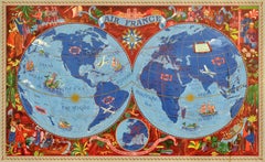
Original Vintage Travel Poster Air France Planisphere Illustrated Map Boucher
By Lucien Boucher
Located in London, GB
Original vintage travel poster advertising Air France featuring a stunning planisphere design by the French artist Lucien Boucher (1889-1971). Colourful depiction of the world featur...
Paper


Original Vintage Poster sle Of Skye Illustrated Map Scotland Macleod Macdonald
Located in London, GB
Original vintage pictorial map poster for the Isle of Skye featuring detailed fun and colourful illustrations with a railway and route map on the islands and places marked on scrolls...
Paper
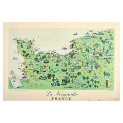

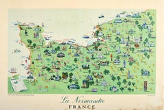
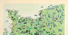
Original Vintage Travel Poster For La Normandie France Normandy Illustrated Map
Located in London, GB
Original vintage travel poster for Normandy - La Normandie France - featuring a pictorial map showing people, historical places of interest, hills and trees, horses, sailing boats an...
Paper

$315Sale Price|20% Off
1852 Map of Haut-Rhin: An Illustrated Gateway to Alsace's Viticultural Splendors
Located in Langweer, NL
This original hand-colored map is from the "Atlas National Illustré," a work by Victor Levasseur, a French geographer and cartographer known for his richly illustrated maps.
Paper

$315Sale Price|20% Off
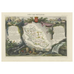
Old Map of Vaucluse, France: A Cartographic Celebration of Viticulture, 1852
Located in Langweer, NL
This original hand-colored map is from the "Atlas National Illustré," a work by Victor Levasseur, a French geographer and cartographer known for his richly illustrated maps.
Paper
Ornate 1850s Map of South America: A Masterpiece of Exploration & Art by Rapkin
Located in Langweer, NL
Rogers, Victorian engraving, British cartographers, antique maps for collectors, decorative wall art, historical prints, cartographic art, exploration and discovery maps, illustrated...
Paper
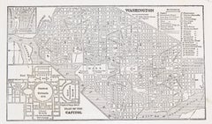
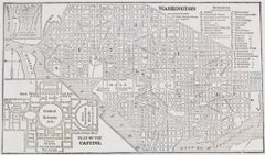
1853 “ Washington” Engraved DC Map from Fanning's Illustrated Gazetteer
Located in Colorado Springs, CO
Presented is an original engraved map of Washington, DC, from 1853. The map was published in Fanning’s Illustrated Gazetteer of the United States.
Paper
$119Sale Price|53% Off
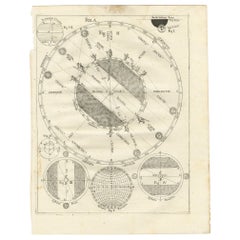
Antique Map Illustrating Solar Eclipses by Scherer, C.1703
Located in Langweer, NL
Antique map of an hemisphere and several figures illustrating the position of the earth, moon and sun.
Paper

$176Sale Price|20% Off
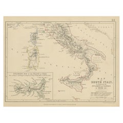
Antique Map of South Italy, illustrating the Invasion of Naples in, 1806
Located in Langweer, NL
Antique battle map titled 'Map of South Italy, to illustrate the invasion of Naples in 1806 etc'.
Paper
$315Sale Price|20% Off
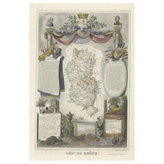
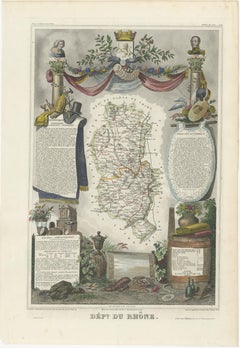
Map of Rhône: Culture and Commerce in Lyon's Silk and Wine Legacy, 1852
Located in Langweer, NL
This original hand-colored map is from the "Atlas National Illustré," a work by Victor Levasseur, a French geographer and cartographer known for his richly illustrated maps.
Paper
Original Vintage Advertising Poster Tahiti New Caledonia Illustrated Route Map
By Hervé Baille
Located in London, GB
Caledonien Tahitien. Fantastic illustrated map design by Herve Baille (1896-1974) depicting the ships sailing at sea with sailing boats, mythical nautical images, fish, an octopus an...
Paper
Old Map of Ancient Rome Illustrating Major Monuments and the Seven Hills, c.1704
Located in Langweer, NL
Map of Ancient Rome Illustrating Major Monuments and the Seven Hills.
Paper
$419Sale Price|20% Off
Antique Map Made After a Roman Papyrus Travel Map, Known as Peutinger Map, 1773
Located in Langweer, NL
Tabula Peutingeriana (Latin for "The Peutinger Map"), also referred to as Peutinger's Tabula or Peutinger Table, is an illustrated itinerarium (ancient Roman road map) showing the la...
Paper
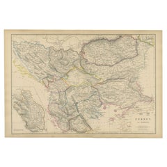
Turkey in Europe & Balkans Map, Antique Hand-Colored Map, 1860
Located in Langweer, NL
Turkey in Europe & Balkans Map, Antique Hand-Colored Map, 1860 This finely detailed antique map illustrates Turkey in Europe together with the broader Balkan Peninsula, presenting a...
Paper
1847 Amerique Septentrionale Framed Map
Located in Stamford, CT
1847 Amerique Septentrionale Framed Map Illustrated by Raimond Bonheur. As found framed condition.
Glass, Wood, Paper

Antique Map of the Holy Land and Paradise – Terrae Canaan Map, c.1720
Located in Langweer, NL
The map illustrates the biblical lands of Canaan, Mesopotamia, Arabia, and Syria with remarkable detail and artistry.
Paper
Map of the Persian Empire circa 1750 by Tirion – Hand-Colored Dutch Map
Located in Langweer, NL
Printed from a copperplate engraving and beautifully hand-colored at the time of publication, the map illustrates the administrative divisions, cities, rivers, and mountain ranges of...
Paper
$213Sale Price|20% Off
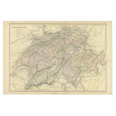
Original Antique Map of Switzerland, 1882
Located in Langweer, NL
This exquisite map intricately illustrates Switzerland's charming landscapes, cities, rivers, and topography, encapsulating the essence of this picturesque country in vibrant detail.
Paper


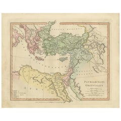
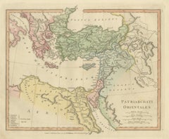
Patriarchatus Occidentalis — Western Patriarchate Map, Wilkinson 1822
Located in Langweer, NL
The map illustrates the geographical extent of the Western Christian patriarchate within the Roman world, presenting a visual interpretation of ecclesiastical organization across Wes...
Paper


Worcestershire & Gloucestershire South Sheet Map – Edward Weller, 1885
Located in Langweer, NL
Among the principal towns and cities shown are Gloucester, known as the "Cathedral City"; Cheltenham, celebrated as one of England's finest Regency spa towns; Cirencester, often call...
Paper

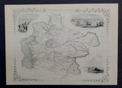
1851 Map of "Independent Tartary", Ric. R018
Located in Norton, MA
Rapkin for John Tallis's 1851 Illustrated Atlas . Tartary Antique Map Tartaria Russia by Tallis Rakin 1851 Title: Independent Tartarie Description: Fine antique map of Tartaria.
Paper
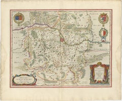
Patriarchati Orientales — Early Christian Patriarchates Map, Wilkinson 1822
Located in Langweer, NL
Maps illustrating early Christian patriarchates hold particular appeal among collectors because they bridge sacred history, classical geography, and church history.
Paper
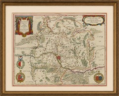
Metz, Lorraine & Verdun Antique Blaeu Atlas Map, France, 1642
Located in Langweer, NL
Published by Willem Janszoon Blaeu in Amsterdam in the 1642 edition of his celebrated atlas Toonneel des Aerdrycx, the map illustrates one of the most strategically important frontie...
Paper
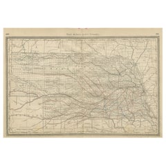
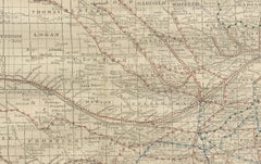
Nebraska Railroad Map 1888 – Rand McNally Antique Lithograph
Located in Langweer, NL
Produced during the great railroad expansion era, the map illustrates the rapidly growing network of rail lines crisscrossing the plains, helping to transform Nebraska from a frontie...
Paper
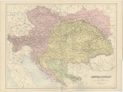
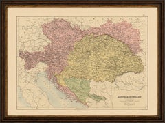
Antique Austria-Hungary Map, Austro-Hungarian Empire, Bartholomew, 1884
Located in Langweer, NL
The map illustrates the Austro-Hungarian Empire in remarkable detail, including present-day Austria, Hungary, Croatia, Slovenia, Bosnia and Herzegovina, Slovakia, the Czech Republic,...
Paper
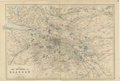
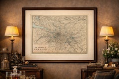
Decorative Glasgow Map, Victorian City and Surroundings Plan, 1885
Located in Langweer, NL
Decorative Glasgow Map, Victorian City and Surroundings Plan, 1885 A finely detailed Victorian map illustrating Glasgow and its surrounding districts, offering a sweeping view of th...
Paper
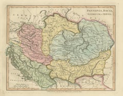
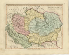
Ancient Pannonia & Dacia Map — Roman Balkans Provinces, Wilkinson 1823
Located in Langweer, NL
Published in London in 1823 by the noted English cartographer Robert Wilkinson, the map forms part of his celebrated classical atlas illustrating the geography of the ancient world t...
Paper
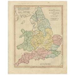
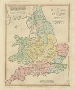
Dioceses of England — Ecclesiastical Map of England, Wilkinson 1801
Located in Langweer, NL
The map presents a detailed ecclesiastical overview of England, illustrating the historical organization of Anglican dioceses and their development over time within a geographic fram...
Paper
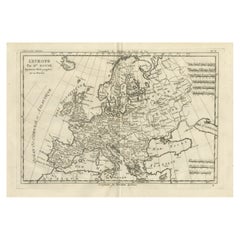
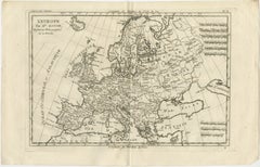
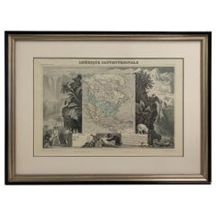
Europe Map by Rigobert Bonne – Enlightenment Cartography c.1780
Located in Langweer, NL
Europe Map by Rigobert Bonne – Enlightenment Cartography c.1780 DESCRIPTION This detailed map of Europe illustrates political and geographic divisions prior to the Napoleonic era.
Paper

Illustrated Map of London from Exhibtion
Located in Alton, GB
Detailed illustrated map of London from the great exhibition of industry of all nations 1851.
Paper
Unavailable
H 47.25 in W 30.71 in
Original Vintage Illustrated Map Poster Afrique Equatoriale Francaise Cameroon
Located in London, GB
Original vintage illustrated map poster for Cameroun AOF Afrique Occidentale Francaise / Cameroon French West Africa showing the Central African country of Cameroon in pink and green...
Paper
Unavailable
H 25.2 in W 38.19 in
Original Vintage Illustrated Map Poster Schematic Map Soviet Union USSR Russia
Located in London, GB
Original vintage illustrated map poster - Schematic Map of the Soviet Union's East Siberia and the Far East - featuring forests, rivers, mountains, cattle and other animals, shipping...
Paper

Unavailable
H 44.1 in W 33.08 in
Original Vintage Africa Travel Poster Belgian Congo Congo Belge Illustrated Map
Located in London, GB
Design by Frans Laboulais (1903-1988) features an illustrated map depicting roads, railways, flight routes, national parks, Catholic churches, protestant churches, hydroelectric dams...
Paper
Unavailable
H 39.38 in W 24.61 in
Original Vintage Illustrated Map Poster Railway Travel Normandy Brittany Paris
By Lucien Boucher
Located in London, GB
Original vintage travel poster featuring a colourful Illustrated Map of the State Railways Sea and Tourism Network / Carte Illustre des Chemins de Fer de l'Etat Reseau de la Mer et d...
Paper
Unavailable
H 33.08 in W 42.52 in
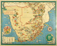
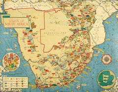
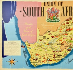
Original Vintage Illustrated Map Poster Union Of South Africa MacDonald Gill
By "Leslie MacDonald ""Max"" Gill"
Located in London, GB
Original vintage illustrated map poster for the Union of South Africa - Philips pictorial map based upon original drawings by notable British graphic designer, cartographer, artist a...
Paper
Unavailable
H 29.93 in W 20.48 in
Original Vintage Advertising Poster Unilever South America Illustrated Map Art
Located in London, GB
Original vintage advertising poster for Unilever in South America featuring a colourful illustrated map marking the factories - Lever & Atkinson Lima Peru / Atkinson Santiago Chile /...
Paper

Unavailable
H 40.16 in W 50.01 in
Original Vintage British Railways Poster Illustrated Map Of The Channel Islands
Located in London, GB
Original vintage travel advertising poster for The Channel Islands - Go there by British Railways published by the Southern Region of British Railways. Colourful illustrated map of t...
Paper

Unavailable
H 29.53 in W 20.08 in
Original Vintage Advertising Poster Unilever Overseas India Illustrated Map
Located in London, GB
Original vintage advertising poster for Unilever Overseas India. Great illustrated map of India showing the industry production for Unilever with images including a tiger in a jungle...
Paper

Unavailable
H 24.02 in W 24.81 in
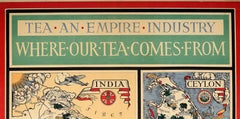
Original Vintage Illustrated Map Poster Empire Industry Where Our Tea Comes From
Located in London, GB
Rare small version depicting colourful illustrated maps of India and Ceylon (now Sri Lanka) featuring the city names in decorative banners as well as images of people, historical pla...
Paper
Unavailable
H 44.89 in W 34.85 in
Original WWII Illustrated Map Poster - Time And Tide Map Of The Atlantic Charter
By "Leslie MacDonald ""Max"" Gill"
Located in London, GB
Original vintage illustrated map poster in Spanish by the notable graphic designer, cartographer and artist MacDonald Gill (Leslie MacDonald Gill aka Max Gill; 1884-1947) commissione...
Paper
Unavailable
H 20.08 in W 28.35 in
Original Vintage Travel Poster Air France Planisphere Illustrated Map Boucher
By Lucien Boucher
Located in London, GB
Original vintage travel poster advertising Air France featuring a stunning planisphere design by the French artist Lucien Boucher (1889-1971). Colourful depiction of the world featur...
Paper
Unavailable
H 24.02 in W 35.83 in
Original Vintage Travel Poster For La Normandie France Normandy Illustrated Map
Located in London, GB
Original vintage travel poster for Normandy - La Normandie France - featuring a pictorial map showing people, historical places of interest, hills and trees, horses, sailing boats an...
Paper

Unavailable
H 22.84 in W 35.04 in
Original Vintage Advertising Poster Tahiti New Caledonia Illustrated Route Map
By Hervé Baille
Located in London, GB
Caledonien Tahitien. Fantastic illustrated map design by Herve Baille (1896-1974) depicting the ships sailing at sea with sailing boats, mythical nautical images, fish, an octopus an...
Paper
Unavailable
H 26.75 in W 31.25 in D 1 in
Early 19th Century Map of Revolutionary France with 13 Belgian and Six Piedmont
By Kirkwood
Located in Pataskala, OH
This framed, hand colored map of France illustrates the departments during the Revolutionary period.
Unavailable
H 35.04 in W 43.71 in
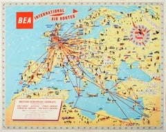
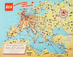
Original Vintage Poster BEA British European Airways International Air Route Map
Located in London, GB
Original vintage travel advertising poster for BEA British European Airways International Air Routes featuring an illustrated map showing the airline route lines and associated links...
Paper
Unavailable
H 40.16 in W 50.01 in
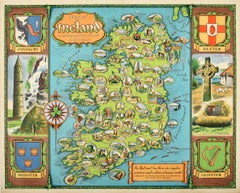
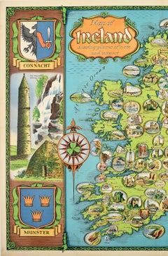
Original Vintage Travel Poster Map Of Ireland Showing Places Of Note & Interest
Located in London, GB
Colourful illustrated map of Ireland by David William Burley (1901-1990) including images of historic architecture such as bridges, castles and churches as well as people swimming, p...
Paper
Unavailable
H 22.84 in W 35.24 in
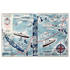
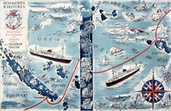
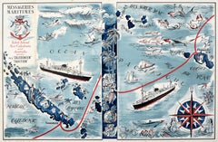
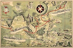
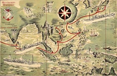
Original Vintage Advertising Poster Messageries Maritimes Far East Map H Baille
By Hervé Baille
Located in London, GB
Original vintage advertising poster for Messageries Maritimes Viet-Nam / Vietnam Cambodge / Cambodia Laos Courriers d'Extreme Orient / Far East featuring a fantastic illustrated map ...
Paper
Unavailable
H 13.39 in W 16.93 in
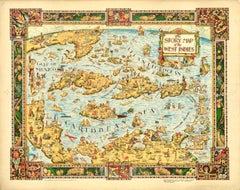
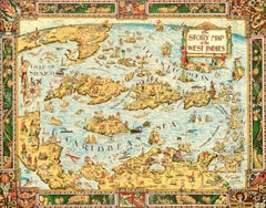
Original Vintage Poster The Story Map Of The West Indies Native Handicraft Motif
Located in London, GB
Original vintage poster - The Story Map of the West Indies - featuring a colourful illustrated map of the islands located on the Gulf of Mexico, Caribbean Sea and Atlantic Ocean mark...
Paper
Unavailable
H 19.69 in W 29.53 in
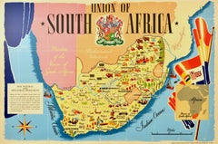
Original Vintage Poster Union Of South Africa Map Natural & Industrial Resources
Located in London, GB
Original vintage illustrated map poster for the Union of South Africa Her Natural and Industrial Resources featuring colourful images of the main cities including Cape Town, Pretoria...
Paper
Unavailable
H 39.38 in W 24.41 in
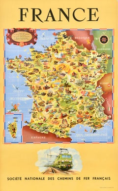
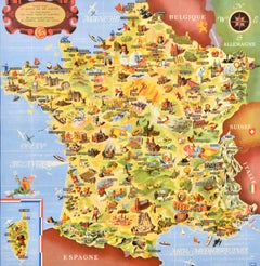
Original Vintage Rail Travel Map Poster France Map SNCF National French Railway
Located in London, GB
Original vintage rail travel map poster - France Societe Nationale des Chemins de Fer Francais - featuring a colourful illustrated map by Jean Cheval and Alex Batany (as Cheval-Batan...
Paper
Unavailable
H 40.16 in W 49.61 in
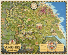
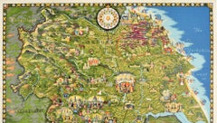
Original Vintage Poster Pictorial Map Of Yorkshire British Railways Train Travel
By E.H. Spencer
Located in London, GB
Original vintage train travel poster - Pictorial Map of Yorkshire by British Railways - featuring a colourful and detailed illustrated map of the historic county of Yorkshire in nort...
Paper
Unavailable
H 80 in W 120 in
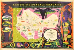
Original Vintage Poster French West Africa Map Afrique Occidentale Francaise Art
By Alain Cornic 1
Located in London, GB
Original vintage poster featuring an illustrated map of French West Africa / Afrique Occidentale Francaise marking the capital cities, towns, ports, Sahara Desert and rivers in Mauri...
Paper
Unavailable
H 27.56 in W 38.39 in
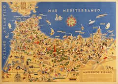
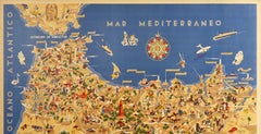
Original Vintage Map Poster Marruecos Espanol Spanish Morocco Illustrated Design
Located in London, GB
Original vintage travel map poster for Marruecos Espanol / Spanish Morocco featuring a great illustration of an outline of the Africa continent marking the major cities and locations...
Paper
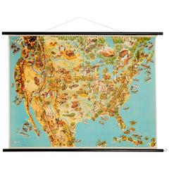
Agricultural Usa School Map, 1960s
Located in Dusseldorf, NRW
Wonderfully detailed school map, fondly illustrating the regional agriculture.
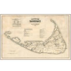
Original Antique 1869 Wall Map of Nantucket
Located in La Jolla, CA
The map illustrates the various place names, roads and townships on the island, along with extensive historic Native American and European settler's information.
Paper

Unavailable
H 78.75 in W 78.75 in D 1.19 in
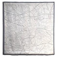
Embroidered Map of London Wall Hanging (custom made)
By Ekta Kaul
Located in Shaftesbury, Dorset
It should be noted that the map illustrated can be customized (at extra cost).
Linen

Unavailable
H 78.75 in W 78.75 in D 1.19 in
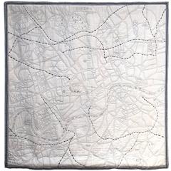
Embroidered Map of London Wall Hanging 'Customizable with Details'
By Ekta Kaul
Located in Blandford Forum, Dorset
It should be noted that the map illustrated can be customized (at extra cost).
Linen