Items Similar to Antique Map of South Italy, illustrating the Invasion of Naples in, 1806


Want more images or videos?
Request additional images or videos from the seller
1 of 6
Antique Map of South Italy, illustrating the Invasion of Naples in, 1806
About the Item
Antique battle map titled 'Map of South Italy, to illustrate the invasion of Naples in 1806 etc'. Map of South Italy illustrating the invasion of Naples. With inset map of the island of Elba. This print originates from 'Atlas to Alison's history of Europe: constructed and arranged under the direction of Sir Archibald Alison (..)' by W. & A.K. Johnston. Published 1852.
- Dimensions:Height: 7.09 in (18 cm)Width: 8.98 in (22.8 cm)Depth: 0.02 in (0.5 mm)
- Materials and Techniques:
- Period:
- Date of Manufacture:1852
- Condition:General age-related toning. Defects in left margin. Shows some wear and foxing, blank verso. Please study image carefully.
- Seller Location:Langweer, NL
- Reference Number:
About the Seller
5.0
Platinum Seller
These expertly vetted sellers are 1stDibs' most experienced sellers and are rated highest by our customers.
Established in 2009
1stDibs seller since 2017
1,929 sales on 1stDibs
Typical response time: <1 hour
- ShippingRetrieving quote...Ships From: Langweer, Netherlands
- Return PolicyA return for this item may be initiated within 14 days of delivery.
More From This SellerView All
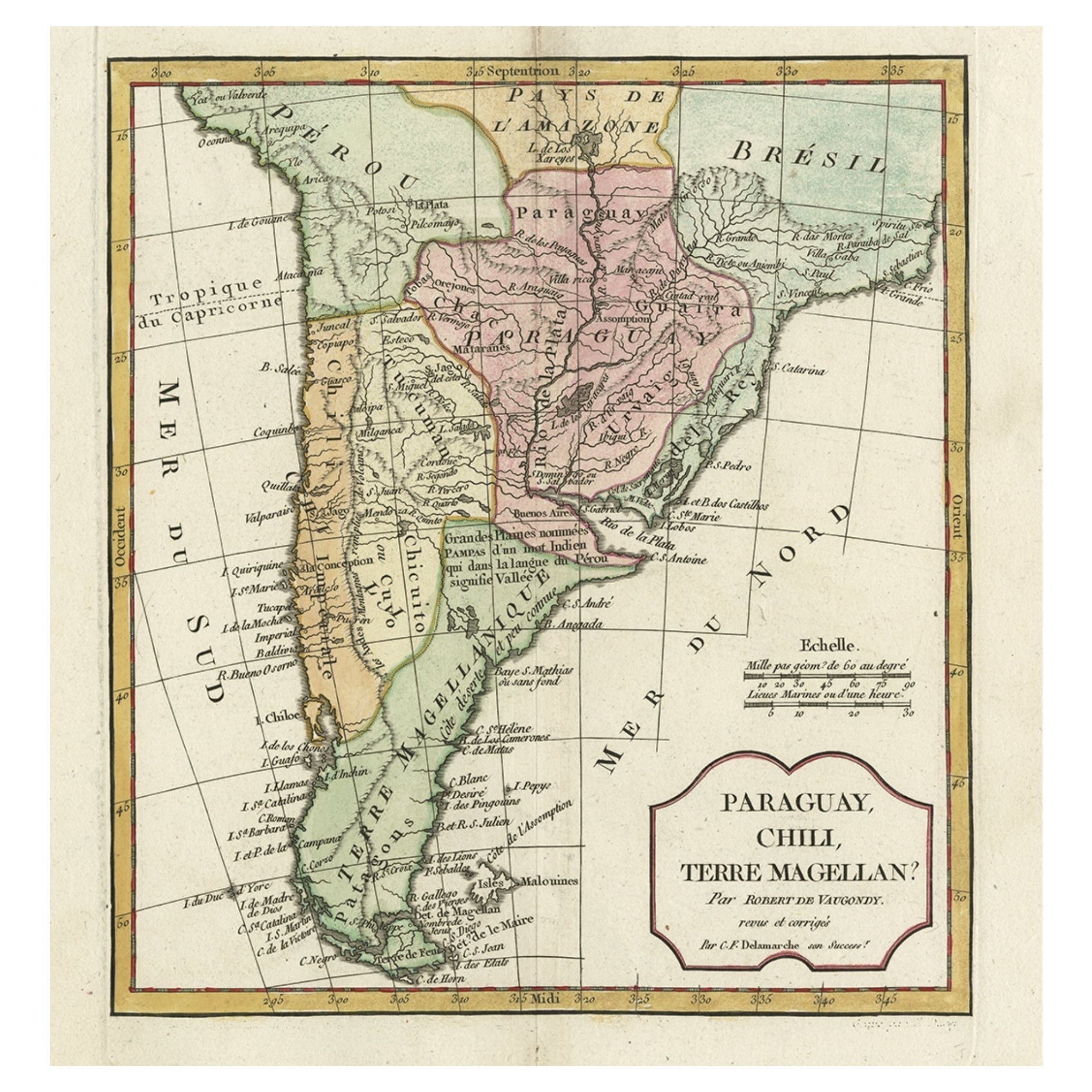
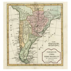
- Decorative Antique Map of the Southern Part of South America, 1806Located in Langweer, NLDescription: Antique map titled 'Paraguay, Chili, Terre Magellan?' Decorative map of the southern part of South America by Robert de Vaugondy, revised and published by Delamarche. Source unknown, to be determined. Artists and Engravers: Charles Francois Delamarche (1740-1817) founded the important and prolific Paris based Maison Delamarche map publishing firm in the late 18th century. A lawyer by trade Delamarche entered the map business with the acquisition from Jean-Baptiste Fortin of Robert de Vaugondy's map plates...Category
Antique Early 1800s Maps
MaterialsPaper
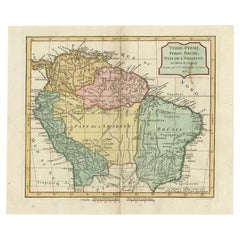
- Antique Map of the Northern Part of South America by Delamarche, 1806Located in Langweer, NLAntique map titled 'Terre-Ferme, Perou, Bresil, Pays de L'Amazone.' This map shows the northern part of South America with Peru, Brazil, Guyana etc. By Robert de Vaugondy, revised an...Category
Antique 19th Century Maps
MaterialsPaper
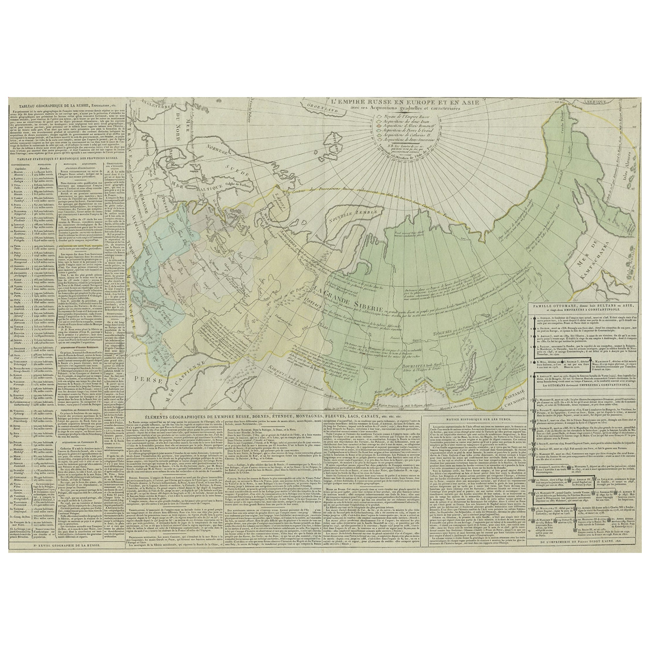
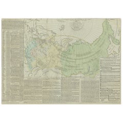
- Antique Map of the Extension of the Russian Empire in the XIXth Century, 1806Located in Langweer, NLAntique map titled 'L'Empire Russe en Europe et en Asie'. Map showing the extension of the Russian Empire at the beginning of the XIXth century. Several letterpress notations are...Category
Antique Early 1800s Maps
MaterialsPaper
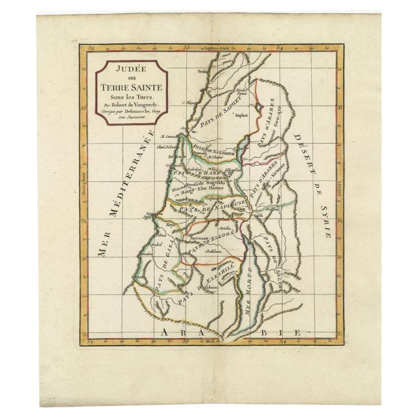
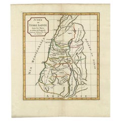
- Antique Map of the Holy Land by Delamarche, 1806By Charles Francois DelamarcheLocated in Langweer, NLAntique map titled 'Judee ou Terre Sainte sous les Turcs.' This map shows the holy land under the Turcs. By Robert de Vaugondy, revised and published by ...Category
Antique 19th Century Maps
MaterialsPaper
- Antique Map of the British Isles by Delamarche, 1806Located in Langweer, NLAntique map titled 'Les Isles Britanniques.' Decorative map of the British Isles by Robert de Vaugondy, revised and published by Delamarche. Source unkno...Category
Antique 19th Century Maps
MaterialsPaper
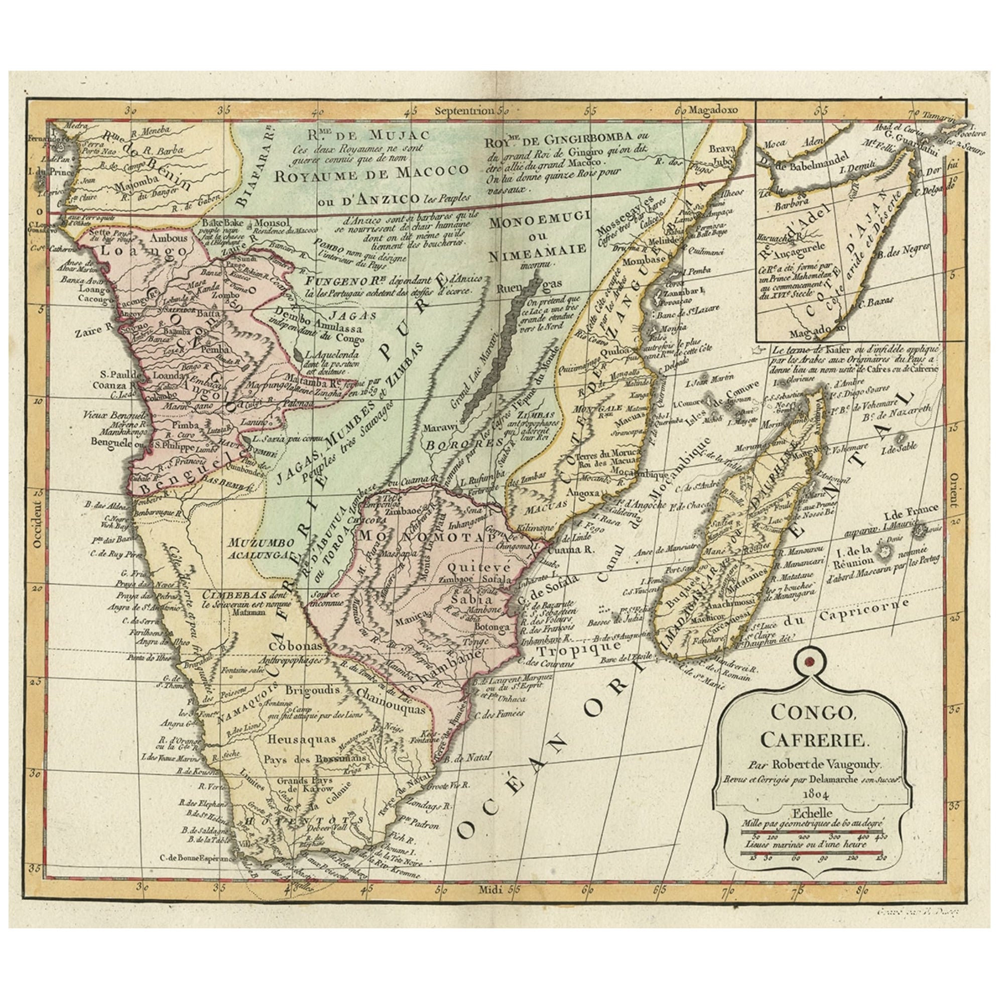
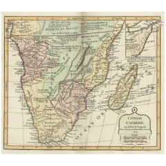
- Decorative Antique Map of the Southern Part of Africa, 1806Located in Langweer, NLAntique map titled 'Congo, Cafrerie.' Decorative map of the southern part of Africa by Robert de Vaugondy, revised and published by Delamarche. Source unknown, to be determined. Artists and Engravers: Charles Francois Delamarche (1740-1817) founded the important and prolific Paris based Maison Delamarche map publishing firm in the late 18th century. A lawyer by trade Delamarche entered the map business with the acquisition from Jean-Baptiste Fortin of Robert de Vaugondy's map plates...Category
Antique Early 1800s Maps
MaterialsPaper

You May Also Like
- Original Antique Map of Sweden, Engraved by Barlow, 1806Located in St Annes, LancashireGreat map of Sweden Copper-plate engraving by Barlow Published by Brightly & Kinnersly, Bungay, Suffolk. 1806 Unframed.Category
Antique Early 1800s English Maps
MaterialsPaper
- Illustrated Map of London from ExhibtionLocated in Alton, GBDetailed illustrated map of London from the great exhibition of industry of all nations 1851.Category
Antique 19th Century Maps
MaterialsPaper
- Original Antique Map of Spain and Portugal, Engraved By Barlow, 1806Located in St Annes, LancashireGreat map of Spain And Portugal Copper-plate engraving by Barlow Published by Brightly & Kinnersly, Bungay, Suffolk. 1806 Unframed.Category
Antique Early 1800s English Maps
MaterialsPaper
- The Kingdom of Naples and Southern Italy: A Hand-Colored 18th Century Homann MapBy Johann Baptist HomannLocated in Alamo, CA"Novissima & exactissimus Totius Regni Neapolis Tabula Presentis Belli Satui Accommo Data" is a hand colored map of southern Italy and the ancient Kingdom of Naples created by Johann...Category
Antique Early 18th Century German Maps
MaterialsPaper
- Original Antique Map of South America, circa 1830Located in St Annes, LancashireGreat map of South America Copper plate engraving Published by Butterworth, Livesey & Co., circa 1830 Unframed.Category
Antique Early 1800s English Other Maps
MaterialsPaper
- Original Antique Map of South Africa, Arrowsmith, 1820Located in St Annes, LancashireGreat map of South Africa. Drawn under the direction of Arrowsmith. Copper-plate engraving. Published by Longman, Hurst, Rees, Orme and Br...Category
Antique 1820s English Maps
MaterialsPaper


Recently Viewed
View AllMore Ways To Browse
Nebraska Map
Antique Map Of Massachusetts
Cornwall Map
Jeffery Brown
Antique Maps Kansas City
Hawaii Map Vintage
Hawaii Vintage Map
Vintage Hawaiian Map
Vintage Hawaiian Maps
Wyoming Map
Antique Montana Maps
Larousse Universel
Lebanon Antique Map
Livonia Map
Map Of Native American Tribes
Native American Tribes Map
Tanzania Antique Map
1847 Rio