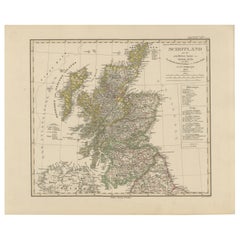
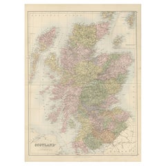
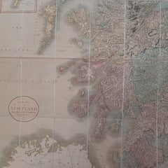
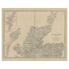
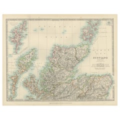
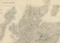
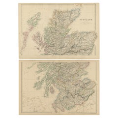
Scotland Map – Highlands, Islands, and Northern England 1858
Located in Langweer, NL
Scotland Map – Highlands, Islands, and Northern England 1858 This attractive antique print shows
Category
Antique Mid-19th Century German Maps
Materials
Paper
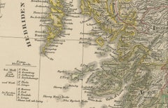
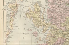
Scotland Map – Highlands, Islands, and Northern England 1858
Located in Langweer, NL
Scotland Map – Highlands, Islands, and Northern England 1858 This attractive antique print shows
Paper
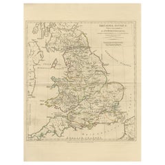
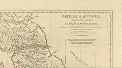
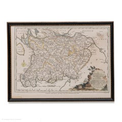
Antique Map of Ancient Britain – Roman England, Wales & Scotland, c.1818
Located in Langweer, NL
Antique Map of Ancient Britain – Roman England, Wales & Scotland, c.1818 Elegant antique map
Paper
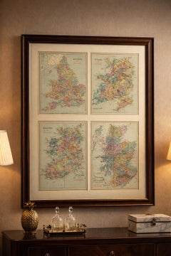
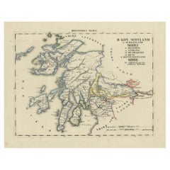
Antique Map of Scotland with Counties and Islands – Black’s Atlas, 1884
Located in Langweer, NL
Here is a catalogue entry in your preferred format for the Scotland map you uploaded: --- Title
Paper
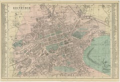
Antique Edinburgh City Map 1885, Victorian Ordnance Atlas Plan by G.W. Bacon
Located in Langweer, NL
Ordnance and actual surveys, the map documents the Scottish capital during a period of remarkable
Paper
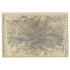
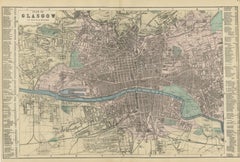
Plan of Glasgow – Large Scale Victorian City Map, George W. Bacon, 1885
Located in Langweer, NL
decorative artwork, this map appeals to collectors of Scottish history, industrial-era cartography, and
Paper

$758Sale Price|20% Off
Antique Map of Scotland by Cary, '1811'
Located in Langweer, NL
Antique map titled 'A New Map of Scotland from the Latest Authorities': **Title**: A New Map of
Linen, Paper
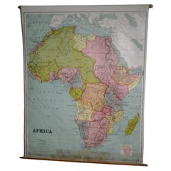
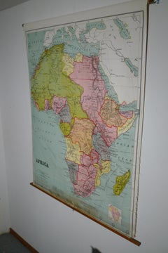
Map of Africa, archival. Printed in Edinburgh, Scotland, 1916. Free Delivery
Located in Madison, WI
Map of Africa from the geography classroom, 1916 edition. Printed in Edinburgh, Scotland. Mounted
Wood, Paper
$237Sale Price|20% Off
Antique Map of Scotland 'Northern' by Johnston, '1909'
Located in Langweer, NL
Antique map titled 'Scotland'. Original antique map of Scotland. With inset map of the Shetland
Paper
$128Sale Price|20% Off
Antique Map of Southern Scotland by Johnston, 1882
Located in Langweer, NL
"Antique map titled 'Scotland'. Old map of Southern Scotland. This map originates from 'The Royal
Paper

$99Sale Price|20% Off
Antique Map of Northern Scotland by Johnston, 1882
Located in Langweer, NL
Antique map titled 'Scotland'. Old map of Northern Scotland. This map originates from 'The Royal
Paper

Map Southern Scotland Thomas Conder Alex Hogg 1795
Located in BUNGAY, SUFFOLK
A new map of the southern part of Scotland containing the counties of Stirling, Lanerk, Renfrew
Paper
British Isles – England, Scotland & Ireland Antique Map, Bonne c1780
Located in Langweer, NL
British Isles – England, Scotland & Ireland Map, Bonne c1780 Description: This elegant map depicts
Paper

Antique Map of Scotland, 1885 – Highlands, Counties & Coastal Detail
Located in Langweer, NL
Antique Map of Scotland, 1885 – Highlands, Counties & Coastal Detail This striking antique map of
Paper

Antique Map of Scotland With an Inset Map of the Shetland Islands, 1854
Located in Langweer, NL
Stunning Map of Scotland that will look beautiful in any setting framed on the wall. Description
Paper


Original Antique Map of Scotland by Dower, circa 1835
Located in St Annes, Lancashire
Nice map of Scotland Drawn and engraved by J.Dower Published by Orr & Smith. C.1835 Unframed
Paper

$274Sale Price|20% Off
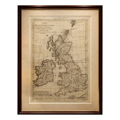
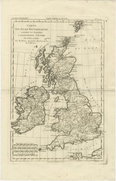
Original Antique Map of England, Ireland, Scotland and Wales
Located in Langweer, NL
Antique map titled 'Les Isles Britanniques, ou sont les Royaumes d Angleterre (..)'. Detailed map
Paper
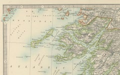
Antique Map of Northern Scotland, 1903, with Intricate Coastal Features
Located in Langweer, NL
Title: Antique Map of Northern Scotland and Islands, 1903, with Intricate Coastal Features
Paper

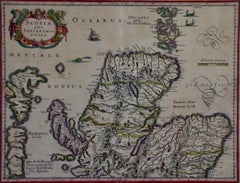
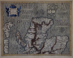
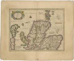
Northern Scotland: A 17th Century Hand-colored Map by Mercator
By Gerard Mercator
Located in Alamo, CA
This is a framed hand-colored 17th century map of Northern Scotland by Gerard Mercator entitled
Paper
Northern Scotland: A 16th Century Hand-colored Map by Mercator
By Gerard Mercator
Located in Alamo, CA
A framed hand-colored 16th century map of Northern Scotland by Gerard Mercator entitled "Scotiae
Paper

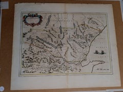
1654 Joan Blaeu Map the Sutherland, Scotland, Entitled "Southerlandia, "Ric0007
Located in Norton, MA
1654 Joan Blaeu map of the Sutherland, Scotland, entitled "Southerlandia," Hand Colored
Paper
Antique Map of Southern Scotland, 1903, with Coastal and Inland Details
Located in Langweer, NL
Title: Antique Map of Southern Scotland, 1903, with Coastal and Inland Details Description: This
Paper

Antique Map of the Northern Part of Scotland by Black '1854'
Located in Langweer, NL
Antique map titled 'Scotland'. Original map of the northern part of Scotland. With an inset map of
Paper
$834Sale Price|20% Off
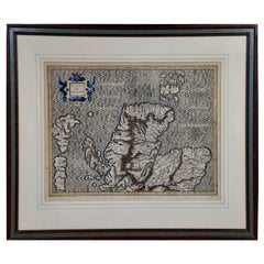
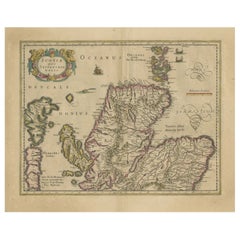
Original Antique Map of the Northern Part of Scotland, circa 1640
Located in Langweer, NL
The antique map, titled 'Scotiae pars septentrionalis,' depicts the northern part of Scotland
Paper
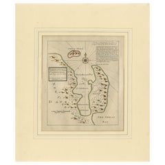
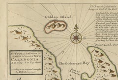
Rare 1699 Map of the Failed Scottish Colony of Caledonia in Panama
Located in Langweer, NL
Rare 1699 Map of the Failed Scottish Colony of Caledonia in Panama This scarce and historically
Paper
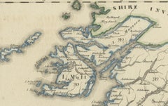
Antique 1830 Map of Scotland with Counties Renfrew, Stirling, Dumbarton and Bute
Located in Langweer, NL
Title: Antique 1830 Map of Scotland with Counties Renfrew, Stirling, Dumbarton, and Bute
Paper
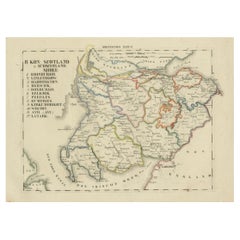
Antique 1830 Map of Southern Scotland with Edinburgh, Berwick, Ayr, and Dumfries
Located in Langweer, NL
Title: Antique 1830 Map of Southern Scotland with Edinburgh, Berwick, Ayr, and Dumfries
Paper

$308Sale Price / set|35% Off
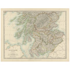
Set of 2 Antique Maps of Scotland by W. G. Blackie, 1859
Located in Langweer, NL
Antique map titled 'Scotland'. Original antique map of Scotland. This map originates from ‘The
Paper


$436Sale Price|20% Off
Small Antique Map of England, Wales, Scotland and Ireland with Original Coloring
Located in Langweer, NL
Scotland on the left and the kings of England on the right, ending with King George I. This map
Paper

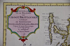
England, Scotland & Ireland: A Hand Colored Map of Great Britain by Tirion
By Isaak Tirion
Located in Alamo, CA
This is a hand-colored double page copperplate map of Great Britain entitled "Nieuwe Kaart van de
Paper
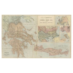
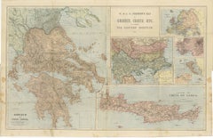
Johnston Map of Greece & Crete 1897 – The Eastern Question Antique Map
Located in Langweer, NL
Here’s a catalogue entry for your **Johnston map of Greece and Crete**: --- **Main Title
Paper
$2,311Sale Price|25% Off
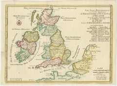
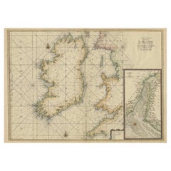
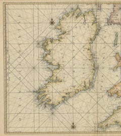
Large 1693 Maritime Map of Irish Sea, West Coasts of Ireland, England, Scotland
Located in Langweer, NL
Ireland together with the western coasts of England and Wales and parts of western Scotland. It was first
Paper
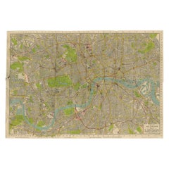
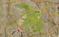
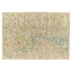
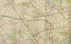
Vintage Map of London – Phillips’ Tape Indicator Map of Central London, c.1930
Located in Langweer, NL
Phillips Tape Indicator Map of London c.1930 – Antique City Plan This large and detailed map of
Paper
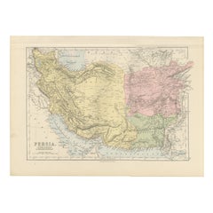
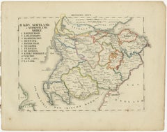
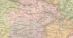
Antique Map of Persia, Afghanistan and Beloochistan – Black’s Atlas, 1884
Located in Langweer, NL
Here is a catalogue entry in your preferred format for the Persia map you uploaded, in plain text
Paper
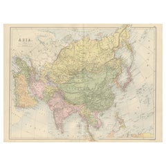
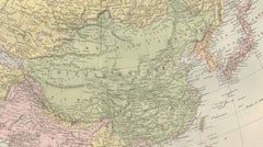
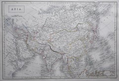
Antique Map of Asia with Political Divisions – Black’s Atlas, 1884
Located in Langweer, NL
Antique Map of Asia with Political Divisions – Black’s Atlas, 1884 This finely engraved and hand
Paper
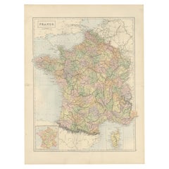
Decorative Antique Map of France in Departments – Collectible Print, 1884
Located in Langweer, NL
Antique Map of France in Departments – Black’s Atlas, 1884 This finely engraved and hand-colored
Paper

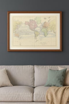
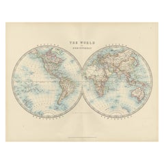
1884 Antique Decorative World Map – Mercator Projection, Victorian Era Print
Located in Langweer, NL
Antique World Map on Mercator’s Projection – Black’s Atlas, 1884 This finely engraved and colored
Paper
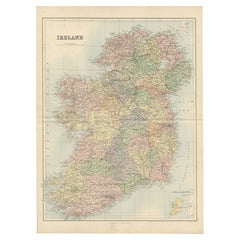

Antique Ireland Map with County Divisions – Decorative Wall Chart, 1884
Located in Langweer, NL
Antique Map of Ireland with Counties – Black’s Atlas, 1884 Description: This finely detailed
Paper
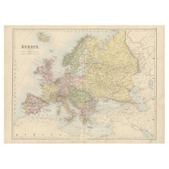
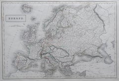
Antique Europe Map with Political Boundaries – Collectible Wall Art, 1884
Located in Langweer, NL
Antique Map of Europe with Political Divisions – Black’s Atlas, 1884 This detailed engraved map of
Paper
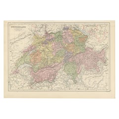
1884 Antique Map of Switzerland – Canton Divisions, Victorian Wall Art
Located in Langweer, NL
Antique Map of Switzerland with Cantons – Black’s Atlas, 1884 This beautifully engraved and hand
Paper
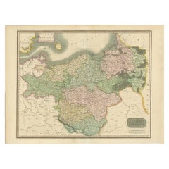
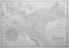
Prussian Dominions Map by John Pinkerton, 1818 - Detailed Copperplate Engraving
Located in Langweer, NL
Prussian Dominions Map by John Pinkerton, 1818 - Detailed Copperplate Engraving Description: This
Paper
Antique World Map in Hemispheres with Delicate Pastel Coloring, 1903
Located in Langweer, NL
Title: Antique World Map in Hemispheres with Delicate Pastel Coloring, 1903 Description: This
Paper

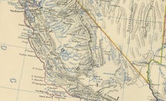
1874 Map of Western United States – Detailed Atlas by Keith Johnston
Located in Langweer, NL
Johnston (1804–1871) was a leading Scottish cartographer known for his precise and elegant maps, and his
Paper
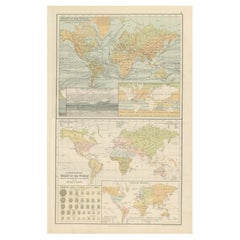
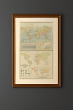
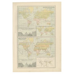
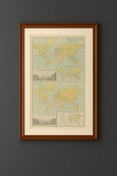
Antique Charts of the World – Physical Features and Ethnographical Map, 1884
Located in Langweer, NL
Antique Charts of the World – Physical Features and Ethnographical Map, 1884 Description: This
Paper
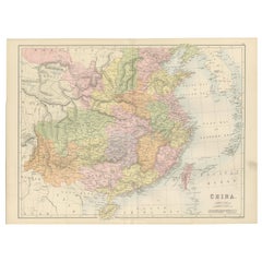
Antique Map of China with Provinces and Treaty Ports – Black’s Atlas, 1884
Located in Langweer, NL
Antique Map of China with Provinces and Treaty Ports – Black’s Atlas, 1884 Description: This
Paper

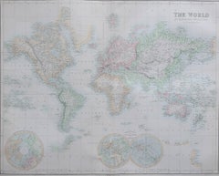
Large Original Antique Map of the World, Fullarton, circa 1870
Located in St Annes, Lancashire
Great map of the World. From the celebrated Royal Illustrated Atlas Lithograph. Original color
Paper

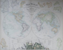
Large Original Antique Map of The World, Fullarton, C.1870
Located in St Annes, Lancashire
Great map of the World. Showing both hemispheres From the celebrated Royal Illustrated Atlas
Paper
Antique Zoological and Botanical Chart of the World – Decorative Map, 1884
Located in Langweer, NL
of the Principal Members of the Animal Kingdom,” maps out the regions where different mammals and
Paper
Vintage Map of London – Bartholomew’s Plan of Central London, c.1929
Located in Langweer, NL
London Central Map c.1929 – Bartholomew Antique City Plan This detailed city plan, titled
Paper

Large Original Antique Map of Europe by Sidney Hall, 1847
Located in St Annes, Lancashire
Great map of Europe Drawn and engraved by Sidney Hall Steel engraving Original colour
Paper

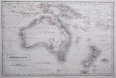
Large Original Antique Map of Australia by Sidney Hall, 1847
Located in St Annes, Lancashire
Great map of Australia Drawn and engraved by Sidney Hall Steel engraving Original colour
Paper

Large Original Antique Map of Asia by Sidney Hall, 1847
Located in St Annes, Lancashire
Great map of Asia Drawn and engraved by Sidney Hall Steel engraving Original colour
Paper

Large Original Antique Map of Poland by Sidney Hall, 1847
Located in St Annes, Lancashire
Great map of Poland Drawn and engraved by Sidney Hall Steel engraving Original colour
Paper

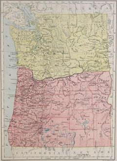
Original Antique Map of the American State of Washington, 1889
Located in St Annes, Lancashire
Great map of Washington Drawn and Engraved by W. & A.K. Johnston Published By A & C Black
Paper

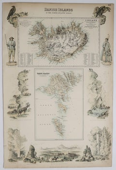
Original Antique Decorative Map of Iceland & Faroe, Fullarton, C.1870
Located in St Annes, Lancashire
Great map of Iceland and The Faroe Islands Wonderful figural border From the celebrated Royal
Paper
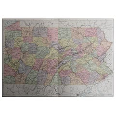
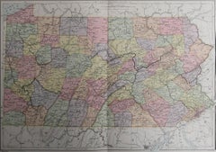
Original Antique Map of the American State of Pennsylvania, 1889
Located in St Annes, Lancashire
Great map of Pennsylvania Drawn and Engraved by W. & A.K. Johnston Published By A & C Black
Paper
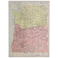
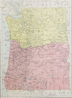
Original Antique Map of the American State of Oregon, 1889
Located in St Annes, Lancashire
Great map of Oregon Drawn and Engraved by W. & A.K. Johnston Published By A & C Black, Edinburgh
Paper
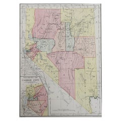
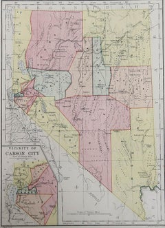
Original Antique Map of the American State of Nevada, 1889
Located in St Annes, Lancashire
Great map of Nevada Drawn and Engraved by W. & A.K. Johnston Published By A & C Black
Paper
Antique and vintage collectibles and curiosities can bring whimsy and wonder to any interior.
Decorating with old scientific instruments, historical memorabilia and vintage musical instruments, as well as other authentic collectibles and curiosities that can be found on 1stDibs, presents an opportunity to create a unique, natural history museum-like atmosphere in your home that can provoke conversation as often as it pays tribute to how far we’ve come in understanding our world.
And bringing collectibles and curiosities into your space is actually on trend — Wunderkammern, or curiosity cabinets, were all the rage in Europe during the 1500s and continued to have adherents there and in the U.S. in the following centuries. Today, however, they’re experiencing a real surge in popularity and influencing how many interior designers are furnishing and decorating homes — combining contemporary with antique, scientific with tribal, earthly with extraterrestrial, Les Lalanne tables with Flemish tapestries.
The original Wunderkammern were entire rooms filled with objects demonstrating their owners’ worldly knowledge: A proper one included artificiala or preciosa (objets d’art); naturalia (such as skeletons, shells, minerals); exotica (taxidermy or dried plants); and scientifica (scientific instruments), frequently alongside religious relics and ancient artifacts.
Pay tribute to a history of rich and diverse musical traditions that have taken shape all over the world by decorating your home with a collection of antique and vintage musical instruments — with a little help from strong hanging wire or some wall hooks, vintage brass instruments such as a gong, French horn or trumpet can help elevate a home office or complement the efforts you’ve made to ensure a welcoming vibe in your home’s entryway. Bells or antique wind instruments can add provocative metallic contrasts to dark woods as tabletop decorative objects.
Create an intriguing focal point with Georgian scientific instruments, such as stick barometers with mahogany cases or lacquered brass telescopes. These items stem from an era named for the monarchies of the four King Georges, who ruled England in succession starting in 1714 (plus King William’s reign, which lasted until 1837). Just as there was beautiful jewelry produced during the period that today is coveted by collectors, there is much to be found in the collectibles and curiosities realm too.
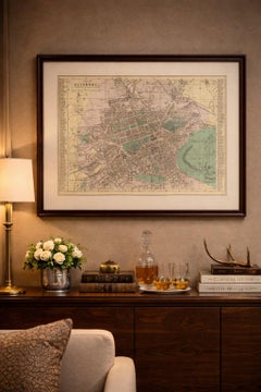
Wanderlust, nostalgia and a shared love of good design are contributing factors to certain trends in decorating — just as vintage trunks and luggage have reappeared as furniture or home accents in a bedroom or foyer, decorating with globes, maps or nautical objects is similarly rooted in the allure of travel and a penchant for the stylish finishing touch that collectibles bring to our homes.
Find a wide range of antique and vintage collectibles and curiosities on 1stDibs.
Produced in 1843, the well-preserved volume is evidence of the author's exacting specifications.
New or old, the coverlets add old-time charm to any space.
Get into the games! These items celebrate the events, athletes, host countries and sporting spirit.
French trendsetter and serial collector Daniel Rozensztroch tells us about his obsession with objects related to seafaring men.
It's hard to resist the allure of a beautiful pool. So, go ahead and daydream about whiling away your summer in paradise.
The sought-after designer worked with the team at Hoffman Creative to produce a monograph that beautifully showcases some of Studio Shamshiri's most inspiring projects.
Italian writer and collector Umberto Pasti opens the doors to his remarkable cave of wonders in North Africa.
Hollywood A-listers, ex-pat aristocrats and art collectors and style setters of all stripes appreciate the allure of the coastal California hamlet — much on our minds after recent winter floods.