
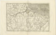
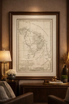
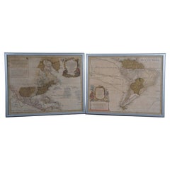
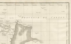
The Americas - Vintage Map - 18th century
Located in Roma, IT
The Americas is a very beautiful vintage map realized in the 18th century by an Italian
Category
18th Century Antique Maps 18th Century
Materials
Paper, Etching
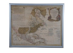
The Americas - Vintage Map - 18th century
Located in Roma, IT
The Americas is a very beautiful vintage map realized in the 18th century by an Italian
Paper, Etching
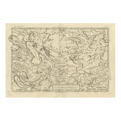
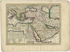
Antique Map of Persia and Georgia by Rigobert Bonne, Circa 1780
Located in Langweer, NL
work. Keywords: Persia map, Iran antique map, Central Asia, Georgia map, 18th century geography
Paper
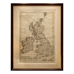
British Isles – England, Scotland & Ireland Antique Map, Bonne c1780
Located in Langweer, NL
Scotland Ireland, antique UK map, 18th century cartography, Rigobert Bonne Technique: Copper engraving
Paper
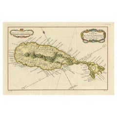
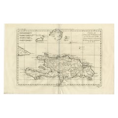
1758 Map of Saint Kitts – St. Christophe, Antique French Engraving
Located in Langweer, NL
. Christophe Bellin map, Caribbean island maps, 18th century French engravings, nautical chart Saint
Paper

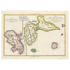
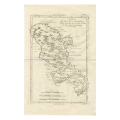
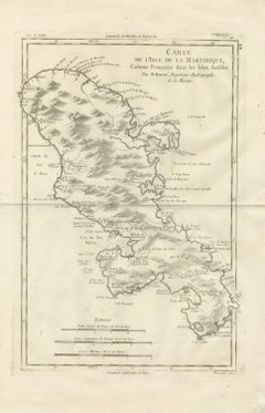
Martinique Map by Rigobert Bonne – French Antique Map, c.1768
Located in Langweer, NL
. Keywords: Rigobert Bonne, antique map, Martinique, French Caribbean, colonial map, 18th century, atlas
Paper

Map of Martinique, Guadeloupe, Marie-Galante, Désirade & Saintes by Bonne, 1788
Located in Langweer, NL
, Martinique, Guadeloupe, Marie-Galante, La Désirade, Les Saintes, French Caribbean, colonial map, 18th century
Paper
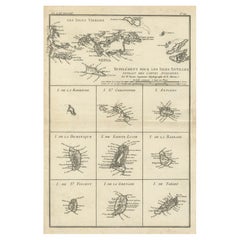
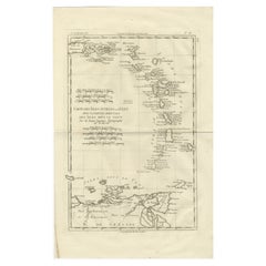
Map of Virgin Islands and Lesser Antilles by Rigobert Bonne, c. 1780
Located in Langweer, NL
antique map, Lesser Antilles maps 18th century, West Indies colonial cartography, Barbuda Antigua St
Paper
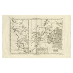

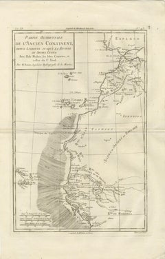
Mozambique Channel & Madagascar – Antique African Sea Chart, Bonne c1780
Located in Langweer, NL
, Madagascar map, East Africa map, Indian Ocean chart, antique sea chart, African coast map, 18th century
Paper
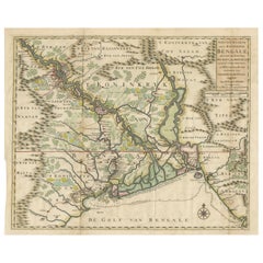
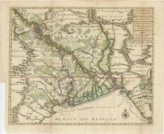
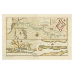
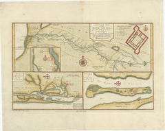
1726 Map of Bengal by Van der Aa after Valentijn – Dutch East Indies
Located in Langweer, NL
, 18th century india map, antique bengal map, orissa map, assam map, tripura map, historical map of india
Paper
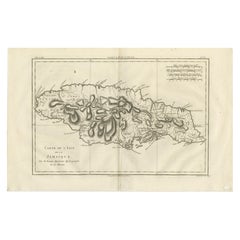
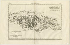
Jamaica – Original Antique Island Map by Rigobert Bonne, c.1780
Located in Langweer, NL
keywords Jamaica antique map, Isle de la Jamaïque map, 18th century Jamaica map, Caribbean island map
Paper
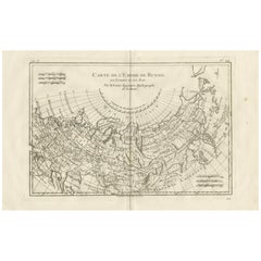
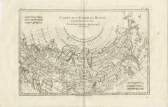
Russian Empire in Europe & Asia – Enlightenment Map by Rigobert Bonne, c.1780
Located in Langweer, NL
in the late 18th century. Restrained in tone yet commanding in presence, the map’s wide horizontal
Paper
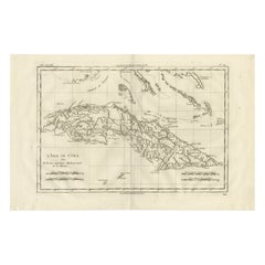
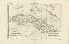
Cuba – Enlightenment Island Map by Rigobert Bonne, c.1780
Located in Langweer, NL
Cuba – Enlightenment Island Map by Rigobert Bonne, c.1780 This finely engraved late-18th-century
Paper
Antique Map Martinique Caribbean Island Chart, Rigobert Bonne French Map, c.1780
Located in Langweer, NL
, Dépôt de la Marine cartography, Enlightenment era map, 18th century Caribbean engraving, West Indies map
Paper
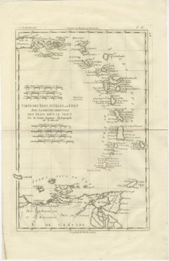
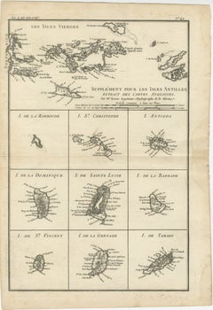
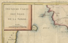
Caribbean & Lesser Antilles – Enlightenment Map by Rigobert Bonne, c.1780
Located in Langweer, NL
late-18th-century map depicts the Lesser Antilles and the eastern Caribbean, titled Carte des Isles
Paper
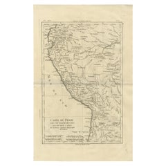
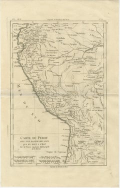
Peru & Upper Amazon – Enlightenment Map by Rigobert Bonne, c.1780
Located in Langweer, NL
-18th-century map depicts Peru and the adjoining regions to the east, titled Carte du Pérou avec une
Paper
Ottoman Empire Map 1719 – Europe Asia Africa, Jean Chiquet, Paris
Located in Langweer, NL
early-18th-century engraved map titled Estats de l’Empire du Grand Seigneur, depicting the Ottoman
Paper
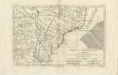
Northern Brazil & Amazon Basin – Enlightenment Map by Rigobert Bonne, c.1780
Located in Langweer, NL
engraved late-18th-century map depicts northern Brazil and the greater Amazon basin, titled Carte de la
Paper
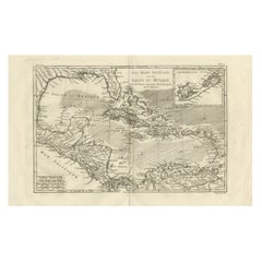
The Caribbean & Gulf of Mexico – Rigobert Bonne’s Antilles Map, c.1780
Located in Langweer, NL
late 18th-century map depicts the Caribbean region and the Gulf of Mexico at a moment of intense
Paper
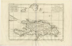
Hispaniola St Domingue – French & Spanish Antilles Map by Rigobert Bonne, c.1780
Located in Langweer, NL
engraved late-18th-century map depicts the island of Hispaniola, titled Carte de l’Isle de St. Domingue
Paper
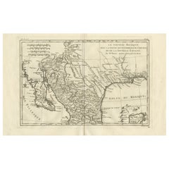
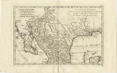
New Mexico & Northern New Spain – Enlightenment Map by Rigobert Bonne, c.1780
Located in Langweer, NL
finely engraved late-18th-century map depicts New Mexico and the northern regions of New Spain, titled Le
Paper
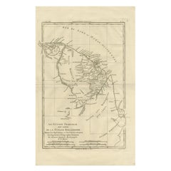
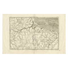
French Guiana & Suriname – Rigobert Bonne’s Colonial Map of the Guianas, c.1780
Located in Langweer, NL
detailed late 18th-century map depicts the Caribbean region and the Gulf of Mexico at a moment of intense
Paper
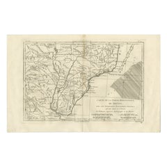
Southern Brazil & Río de la Plata – Enlightenment Map by Rigobert Bonne, c.1780
Located in Langweer, NL
: This finely engraved late-18th-century map depicts southern Brazil and the adjoining Spanish
Paper
Antique Map of the Location of the Garden of Eden and Travels of the Patriarchs
Located in Langweer, NL
map Holy Land cartography Middle East map 18th-century cartography Antique map Travels of
Paper
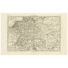
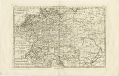
Germany, Bohemia & Hungary – Enlightenment Map by Rigobert Bonne, c.1780
Located in Langweer, NL
-18th-century map depicts Germany, Bohemia, Hungary, and adjoining parts of Central and Eastern Europe
Paper
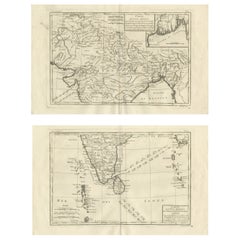
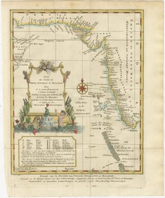
India & Bengal after Bonne – Enlightenment French Cartography, Two-Map Set, 1780
Located in Langweer, NL
regional maps, together offering a coherent late-18th-century French view of the Indian subcontinent at a
Paper
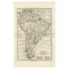
South America – Original Antique Enlightenment Map by Rigobert Bonne, c.1780
Located in Langweer, NL
South America – Enlightenment Map by Rigobert Bonne, c.1780 This finely engraved late-18th-century
Paper
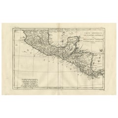
Southern Mexico & New Spain – Enlightenment Map by Rigobert Bonne, c.1780
Located in Langweer, NL
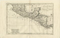
late-18th-century map depicts southern Mexico and Central America, titled Partie Méridionale de
Paper
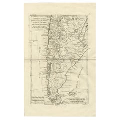
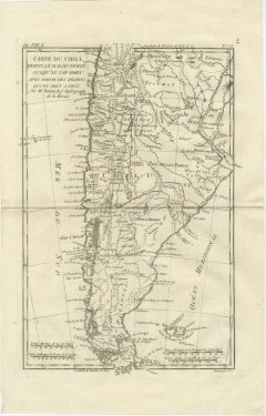
Chile from Peru to Cape Horn – Enlightenment Map by Rigobert Bonne, c.1780
Located in Langweer, NL
late-18th-century map depicts Chile from southern Peru to Cape Horn, titled Carte du Chili, depuis le
Paper
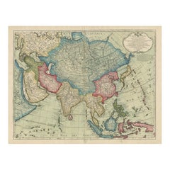
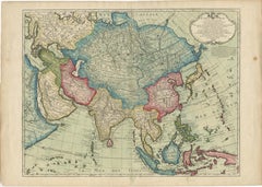
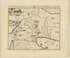
1723 Antique Map of Asia – Carte d’Asie by Guillaume Delisle, Paris
Located in Langweer, NL
'Guillaume Delisle' and published in Paris in 1723, is one of the most influential 18th-century maps of Asia
Paper
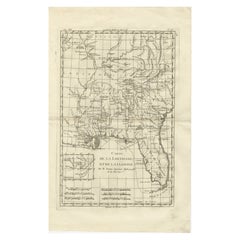
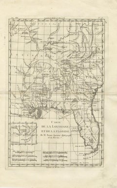
Antique Map Louisiana & Mississippi Valley — Florida Region, Bonne c.1780
Located in Langweer, NL
, Enlightenment cartography USA, Dépôt de la Marine map, 18th century America engraving, Gulf Coast historical map
Paper
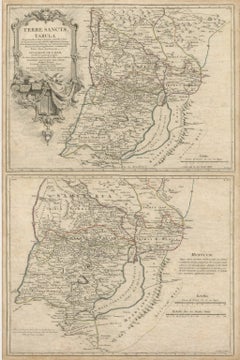
Antique Holy Land Map, Terrae Sanctae Tabula – Guillaume De L’Isle, 1782
Located in Langweer, NL
historically significant late-18th century map of the Holy Land by Guillaume De L’Isle, one of the most
Paper
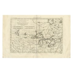
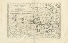
Great Lakes Antique Map — Canada, Midwest USA, Enlightenment Era, Bonne c.1780
Located in Langweer, NL
map, 18th century Great Lakes engraving, early Midwest USA map, indigenous territories map antique
Paper
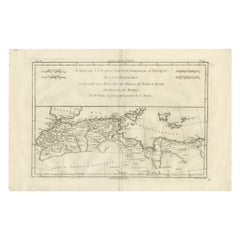
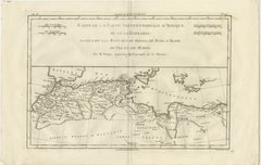
Antique Map North Africa Barbary Coast with Morocco Algeria Tunisia, Bonne c1780
Located in Langweer, NL
historical map, Barbary states cartography, French colonial geography map, 18th century Africa map
Paper
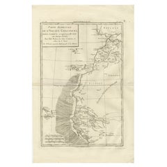
Antique Map West Africa Morocco Canary Islands Lisbon Sierra Leone Bonne, c1780
Located in Langweer, NL
cartography France, Dépôt de la Marine map, 18th century Africa engraving, Lisbon Portugal antique map
Paper

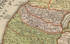
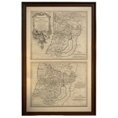
1718 Holy Land Map - Twelve Tribes, Six Provinces, Hand-Colored, Antique Map
Located in Langweer, NL
Land map - Antique biblical map - 18th-century cartography - Terra Sancta - Map of Twelve
Paper
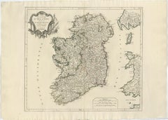
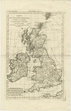
Ireland Antique Map – Royaume d’Irlande, De Vaugondy, Venice 1778
Located in Langweer, NL
finely engraved 18th-century map depicts the Kingdom of Ireland under the title Royaume d’Irlande divisé
Paper
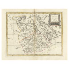
Nubia and Abyssinia – Venetian Map of Northeast Africa, Zatta, 1784
Located in Langweer, NL
, African exploration map, 18th century map Africa, Venetian map, Antonio Zatta, Atlante Novissimo
Paper
River Sanaga, West Africa – Elegant French Exploration Map, c.1750
Located in Langweer, NL
, African exploration map, 18th century map Africa, Venetian map, Antonio Zatta, Atlante Novissimo
Paper
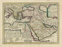
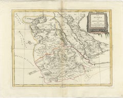
1773 Map of Persia, Gujarat & Malabar Coasts – Arabia to India, Hand-Colored
Located in Langweer, NL
finely engraved and delicately hand-colored 18th-century map titled Kaart van de Kusten van Persië
Paper
$2,400Sale Price|20% Off
18th Century Antique Conrad Lotter Septentrionalis Meridionalis American Maps
Located in Dayton, OH
, becoming one of the most prominent mid-18th century map publishers working in the German school. After T.C
Paper

Antique 18th Century Map of the Province of Pensilvania 'Pennsylvania State'
Located in Philadelphia, PA
A fine antique of the colony of Pennsylvania. Noted at the top of the sheet as a 'Map of the
Paper
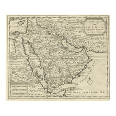
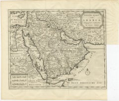
18th Century Map of Arabia – Tirion, Amsterdam c.1730
Located in Langweer, NL
detailed 18th-century map, titled “Nieuwe Kaart van Arabia,” was published in Amsterdam by Isaak Tirion
Paper
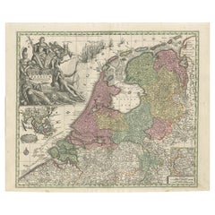
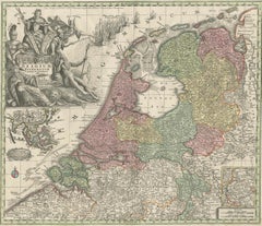
Dutch Republic & East Indies, Belgium Foederatum Map by Seutter, 18th Century
Located in Langweer, NL
Dutch Republic & East Indies, Belgium Foederatum Map by Seutter, 18th Century This impressive
Paper
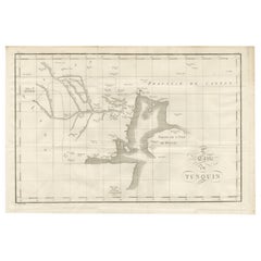
Antique Map of Tonkin and Hainan Island – 18th Century French Engraving
Located in Langweer, NL
Antique Map of Tonkin and Hainan Island – 18th Century French Engraving This is the “5me Carte du
Paper
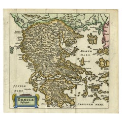

Charming 18th Century Miniature Map of Greece, 1685
Located in Langweer, NL
antique maps from the 16th to the 20th centuries. Buying and collecting antique maps is a tradition that
Paper

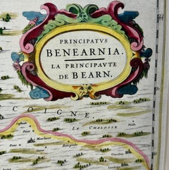
18th Century Map of French Pyrenees Region of France
Located in Haddonfield, NJ
An antique map titled "Principatus Benearnia, La Principaute De Bearn" created by the renowned
Wood, Paper
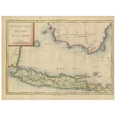
Java and Bali with Borneo Coast – 18th Century French Colonial Map
Located in Langweer, NL
Java and Bali with Borneo Coast – 18th Century French Colonial Map This original copperplate
Paper
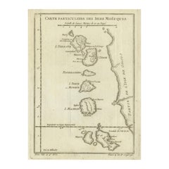

Antique Map of the Moluccas (Maluku Islands), Indonesia – Bellin, 18th Century
Located in Langweer, NL
Antique Map of the Moluccas (Maluku Islands), Indonesia – Bellin, 18th Century Original antique
Paper
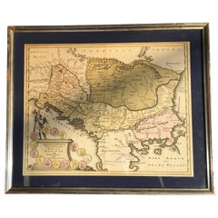
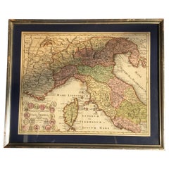
Four 18th Century Engraved and Hand-Colored Maps by Weigel
By Christoph Weigel
Located in Copenhagen, K
Small collection of four engraved maps of Italy, Balkan and of Central Asia. Two are of Italy
Paper
Rare 1791 von Reilly Map of Friesland Province, Netherlands, 18th Century
Located in Langweer, NL
Antique General Map of Friesland by von Reilly, 1791 Original engraved map titled *Friesland
Paper

$795Sale Price|36% Off
18th Century Map of the Southern Balkans by Giovanni Maria Cassini
By Giovanni Maria Cassini
Located in Hamilton, Ontario
18th century map by Italian engraver Giovanni Maria Cassini (Italy 1745-1824). Map of the Southern
Paper

18th Century Emanuel Bowen Map of County of York, c.1740
By Emanuel Bowen
Located in Royal Tunbridge Wells, Kent
Antique 18th century British rare and original Emanuel Bowen (1694-1767) map of the County of York
Paper

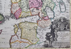
Scandinavia & Portions of Eastern Europe: 18th Century Hand-Colored Homann Map
By Johann Baptist Homann
Located in Alamo, CA
An early 18th century hand-colored copper-plate map entitled "Regni Sueciae in omnes suas
Paper

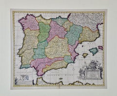
18th Century Hand Colored Map of Spain and Portugal by Visscher
By Nicolaes Visscher II
Located in Alamo, CA
This is an early 18th century map of Spain and Portugal, with attractive original hand-coloring
Paper

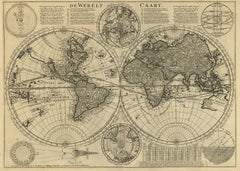
Mid-18th Century Antique World Map by R. & J. Wetstein, Netherlands
Located in Langweer, NL
Antique world map titled 'De Werelt Caart'. A scarce and richly detailed double hemisphere world
Paper

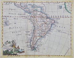
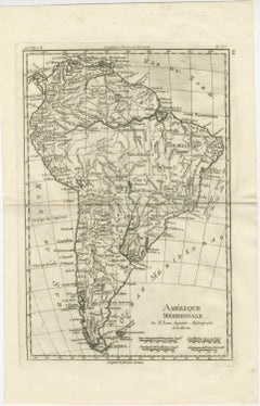
South America: Hand-colored 18th Century Framed Map by Thomas Jefferys
By Thomas Jefferys
Located in Alamo, CA
This detailed hand-colored map of South America by Thomas Jefferys was published in London in 1750
Paper
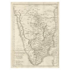
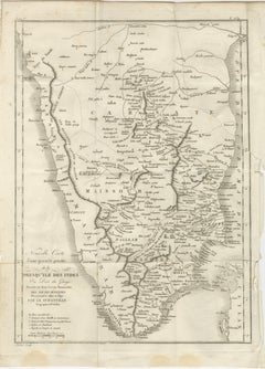
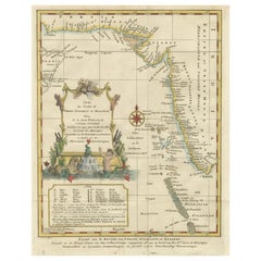
Antique Map of Southern India – French Engraving by D’Anville, 18th Century
Located in Langweer, NL
This finely detailed antique map presents the southern portion of India, engraved in the 18th
Paper
Antique and vintage collectibles and curiosities can bring whimsy and wonder to any interior.
Decorating with old scientific instruments, historical memorabilia and vintage musical instruments, as well as other authentic collectibles and curiosities that can be found on 1stDibs, presents an opportunity to create a unique, natural history museum-like atmosphere in your home that can provoke conversation as often as it pays tribute to how far we’ve come in understanding our world.
And bringing collectibles and curiosities into your space is actually on trend — Wunderkammern, or curiosity cabinets, were all the rage in Europe during the 1500s and continued to have adherents there and in the U.S. in the following centuries. Today, however, they’re experiencing a real surge in popularity and influencing how many interior designers are furnishing and decorating homes — combining contemporary with antique, scientific with tribal, earthly with extraterrestrial, Les Lalanne tables with Flemish tapestries.
The original Wunderkammern were entire rooms filled with objects demonstrating their owners’ worldly knowledge: A proper one included artificiala or preciosa (objets d’art); naturalia (such as skeletons, shells, minerals); exotica (taxidermy or dried plants); and scientifica (scientific instruments), frequently alongside religious relics and ancient artifacts.
Pay tribute to a history of rich and diverse musical traditions that have taken shape all over the world by decorating your home with a collection of antique and vintage musical instruments — with a little help from strong hanging wire or some wall hooks, vintage brass instruments such as a gong, French horn or trumpet can help elevate a home office or complement the efforts you’ve made to ensure a welcoming vibe in your home’s entryway. Bells or antique wind instruments can add provocative metallic contrasts to dark woods as tabletop decorative objects.
Create an intriguing focal point with Georgian scientific instruments, such as stick barometers with mahogany cases or lacquered brass telescopes. These items stem from an era named for the monarchies of the four King Georges, who ruled England in succession starting in 1714 (plus King William’s reign, which lasted until 1837). Just as there was beautiful jewelry produced during the period that today is coveted by collectors, there is much to be found in the collectibles and curiosities realm too.
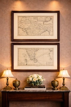
Wanderlust, nostalgia and a shared love of good design are contributing factors to certain trends in decorating — just as vintage trunks and luggage have reappeared as furniture or home accents in a bedroom or foyer, decorating with globes, maps or nautical objects is similarly rooted in the allure of travel and a penchant for the stylish finishing touch that collectibles bring to our homes.
Find a wide range of antique and vintage collectibles and curiosities on 1stDibs.
Produced in 1843, the well-preserved volume is evidence of the author's exacting specifications.
New or old, the coverlets add old-time charm to any space.
Get into the games! These items celebrate the events, athletes, host countries and sporting spirit.
French trendsetter and serial collector Daniel Rozensztroch tells us about his obsession with objects related to seafaring men.
It's hard to resist the allure of a beautiful pool. So, go ahead and daydream about whiling away your summer in paradise.
The sought-after designer worked with the team at Hoffman Creative to produce a monograph that beautifully showcases some of Studio Shamshiri's most inspiring projects.
Italian writer and collector Umberto Pasti opens the doors to his remarkable cave of wonders in North Africa.
Hollywood A-listers, ex-pat aristocrats and art collectors and style setters of all stripes appreciate the allure of the coastal California hamlet — much on our minds after recent winter floods.