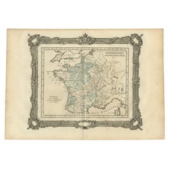

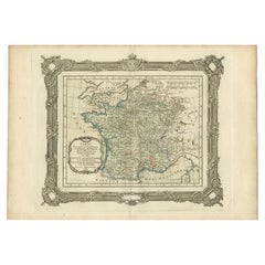
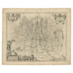
Antique Map of France under the Reign of St. Louis by Zannoni, 1765
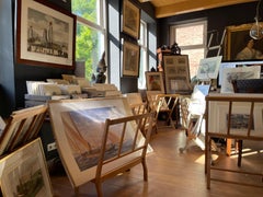
Located in Langweer, NL
We offer a wide range of authentic antique maps for any budget.
Category
18th Century Authentic Antique Maps
Materials
Paper
Antique Map of France under the Reign of St. Louis by Zannoni, 1765
Located in Langweer, NL
We offer a wide range of authentic antique maps for any budget.
Paper
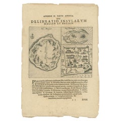
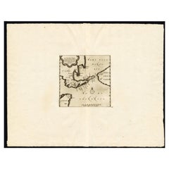
Antique Map of the Islands of Macian and Bacian by De Bry, 1619
Located in Langweer, NL
We offer a wide range of authentic antique maps for any budget.
Paper
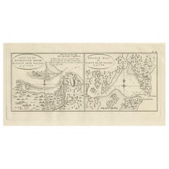
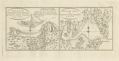
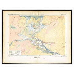
Antique Map of Endeavour River and Botany Bay, New South Wales, Australia, 1803
Located in Langweer, NL
We offer a wide range of authentic antique maps for any budget.
Paper
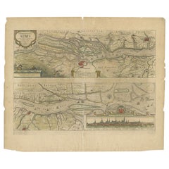

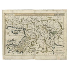
Antique Map of the Course of the Elbe River by Janssonius, c.1650
By Johannes Janssonius
Located in Langweer, NL
We offer a wide range of authentic antique maps for any budget
Paper
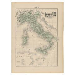

Antique Map of Italy with Vignette of Saint Angu Castle in Rome, 1880
Located in Langweer, NL
We offer a wide range of authentic antique maps for any budget.
Paper
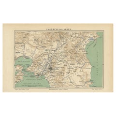

Antique Map of the Region of Athens from a German Atlas of 1893
Located in Langweer, NL
We offer a wide range of authentic antique maps for any budget.
Paper
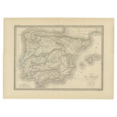

Antique Map of Iberia or the Iberian Peninsula with Portugal and Spain, 1842
Located in Langweer, NL
We offer a wide range of authentic antique maps for any budget.
Paper

Antique Map of France up-to the Peace of Ryswick by Zannoni, 1765
Located in Langweer, NL
We offer a wide range of authentic antique maps for any budget.
Paper


$419Sale Price|20% Off
Large Antique Map of the Lower Nile Valley Including Egypt and Nubia, 1842
Located in Langweer, NL
We offer a wide range of authentic antique maps for any budget.
Paper

Antique Map of the Mouth of the Amu Darya River by Reclus, 1881
Located in Langweer, NL
We offer a wide range of authentic antique maps for any budget
Paper
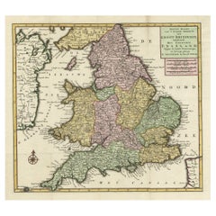
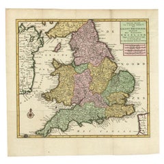
Antique Map of the South Part of Great Britain by Tirion, c.1750
By Isaak Tirion
Located in Langweer, NL
We offer a wide range of authentic antique maps for any budget.
Paper


$409Sale Price|20% Off
Antique Map of the Vermandois Region 'Picardy' in France by Janssonius, C.1640
Located in Langweer, NL
We offer a wide range of authentic antique maps for any budget.
Paper
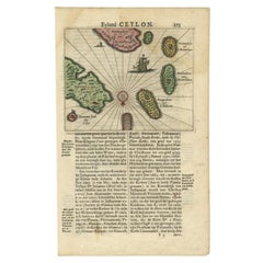

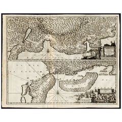
Antique 17th Century Map of the Islands Near Ceylon or Sri Lanka, 1672
Located in Langweer, NL
We offer a wide range of authentic antique maps for any budget.
Paper
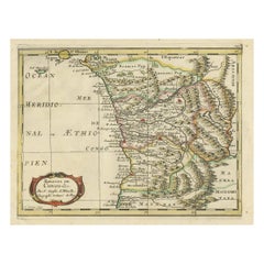
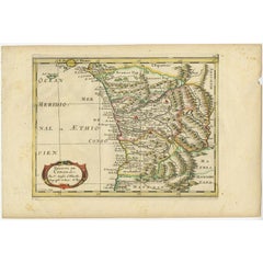
Antique Map of Gabon, Angola and the Congo Region in Africa c.1680
Located in Langweer, NL
We offer a wide range of authentic antique maps for any budget.
Paper

Antique Map of the Region of Aire-sur-L'Adour by Janssonius, 1657
Located in Langweer, NL
We offer a wide range of authentic antique maps for any budget.
Paper

$2,095Sale Price|20% Off
Rare Antique Map of Japan with Place Names Given in Dutch Nomenclature, 1726
Located in Langweer, NL
We offer a wide range of authentic antique maps for any budget.
Paper


Antique Map of England and London with Two Large Allegorical Views, c.1720
Located in Langweer, NL
We offer a wide range of authentic antique maps for any budget.
Paper


Antique Map of The Nile, Egypt and the Red Sea by Bachiene, 1765
Located in Langweer, NL
We offer a wide range of authentic antique maps for any budget.
Paper
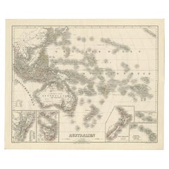

Map of Australia, New Zealand, Part of China, Japan and Southeast Asia, 1857
Located in Langweer, NL
We offer a wide range of authentic antique maps for any budget.
Paper

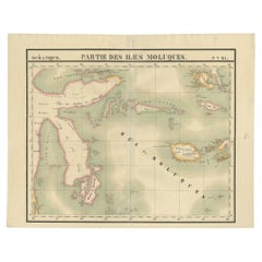
Antique Map of Ambelau and Buru Island, Maluku or Moluccas in Indonesia, 1726
Located in Langweer, NL
We offer a wide range of authentic antique maps for any budget.
Paper

Antique Map of the Mediterranean and the Persian Gulf by Danckerts, c.1718
Located in Langweer, NL
We offer a wide range of authentic antique maps for any budget.
Paper

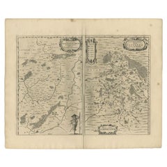
Antique Map of the Region of Étampes and Sens by Janssonius, c.1650
Located in Langweer, NL
We offer a wide range of authentic antique maps for any budget.
Paper
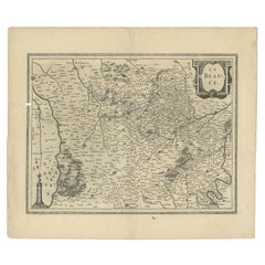
Antique Map of the Region of Beauce in France by Janssonius, c.1650
Located in Langweer, NL
We offer a wide range of authentic antique maps for any budget.
Paper
$214Sale Price|20% Off
Antique Map of the Passage Between the Atlantic and Pacific Oceans, circa 1753
Located in Langweer, NL
We offer a wide range of authentic antique maps for any budget.
Paper
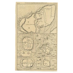

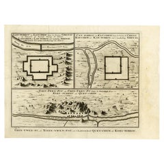
Antique Map of Cities of the Province of Che-Kyang in China, 1738
Located in Langweer, NL
We offer a wide range of authentic antique maps for any budget.
Paper

Antique Map of the Region of Zutphen in The Netherlands by Janssonius, 1647
By Johannes Janssonius
Located in Langweer, NL
We offer a wide range of authentic antique maps for any budget.
Paper
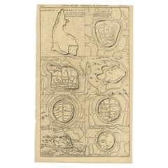

Antique Map of Cities of the Province of Che-Kiang in China, 1738
Located in Langweer, NL
We offer a wide range of authentic antique maps for any budget.
Paper
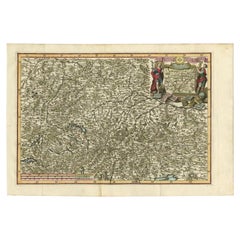

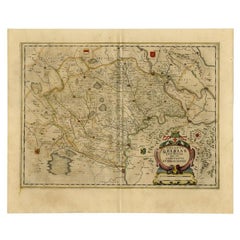
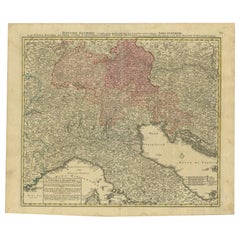
Very Detailed Antique Map of the Jesuit Province of Bavaria, Germany, c.1700
Located in Langweer, NL
We offer a wide range of authentic antique maps for any budget.
Paper

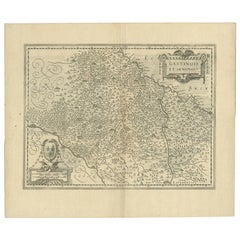
Antique Map of the Region of Vermandois and Cappelle, France by Janssonius, 1657
By Johannes Janssonius
Located in Langweer, NL
We offer a wide range of authentic antique maps for any budget.
Paper
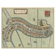

Antique Hand-Colored Map of the Frisian City of IJlst, The Netherlands, 1649
Located in Langweer, NL
We offer a wide range of authentic antique maps for any budget.
Paper

Antique Map of the Region of Osaka and Hirado Island in Japan, 1725
By Pieter Van Der Aa
Located in Langweer, NL
We offer a wide range of authentic antique maps for any budget.
Paper
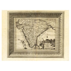

Rare Engraved Antique Map of India with Elephants in the Cartouche, c.1725
Located in Langweer, NL
We offer a wide range of authentic antique maps for any budget.
Paper


Antique Map of Denmark with Details of Fortresses, Cities, Towns Etc, c.1680
Located in Langweer, NL
We offer a wide range of authentic antique maps for any budget.
Paper

Antique Map of Three Chinese Cities in Chensi and Koei Tcheou, c.1758
Located in Langweer, NL
We offer a wide range of authentic antique maps for any budget.
Paper


$419Sale Price|20% Off
Antique Map of Italy, Showing Corsica, Sardinia, Croatia, Malta and More, C.1740
Located in Langweer, NL
We offer a wide range of authentic antique maps for any budget.
Paper

Antique Map of the Region of Calais and The Vermandois Region by Ortelius
Located in Langweer, NL
We offer a wide range of authentic antique maps for any budget.
Paper
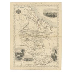
Antique Map of British Guayana with Insets of Georgetown, Devil's Rock Etc, 1851
Located in Langweer, NL
We offer a wide range of authentic antique maps for any budget.
Paper
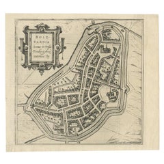

Antique Map of the City of Bolsward, Friesland in The Netherlands, c.1598
Located in Langweer, NL
We offer a wide range of authentic antique maps for any budget.
Paper


Antique Map of Cities in the Hubei and Hunan Provinces of China, 1755
By Jacques-Nicolas Bellin
Located in Langweer, NL
We offer a wide range of authentic antique maps for any budget.
Paper
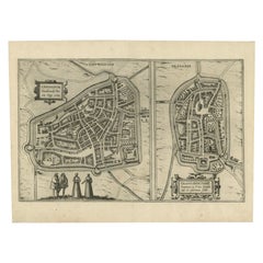

Antique Map of the City of Leeuwarden and Franeker by Braun & Hogenberg, 1580
Located in Langweer, NL
We offer a wide range of authentic antique maps for any budget.
Paper
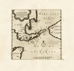
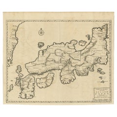
Extremely Rare Map of The land of Eso or Hokkaido in Japan, 1725
Located in Langweer, NL
We offer a wide range of authentic antique maps for any budget.
Paper


Antique Map of India as Described It Was before the 5th Century, 1744
Located in Langweer, NL
We offer a wide range of authentic antique maps for any budget.
Paper
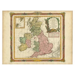

Antique Map of Great Britain and Ireland by Brion de la Tour, 1766
Located in Langweer, NL
We offer a wide range of authentic antique maps for any budget.
Paper
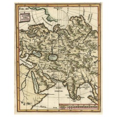

Antique Map of Central Asia Wiht Nova Zembla as an Island, C.1700
Located in Langweer, NL
We offer a wide range of authentic antique maps for any budget.
Paper

Antique Map of the Danube River and Surroundings by Homann Heirs, c.1730
By Homann Heirs
Located in Langweer, NL
We offer a wide range of authentic antique maps for any budget.
Paper
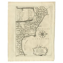

Antique Map of the City of Algiers and Surroundings in Northern Africa, 1773
Located in Langweer, NL
We offer a wide range of authentic antique maps for any budget.
Paper
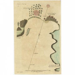

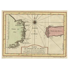
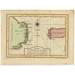
Antique Map of the Harbour of Praia, Santiago Island, Cape Verde, c.1750
Located in Langweer, NL
We offer a wide range of authentic antique maps for any budget
Paper
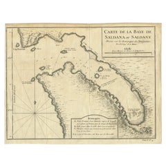

Antique Map of Saldanha Bay 'Near Cape Town, South Africa' by Bellin, 1750
By Jacques-Nicolas Bellin
Located in Langweer, NL
We offer a wide range of authentic antique maps for any budget.
Paper


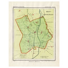
Antique Map of The Dutch Province of Groningen by De Wit, c.1680
Located in Langweer, NL
We offer a wide range of authentic antique maps for any budget.
Paper

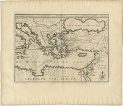
Antique Map of Eastern Mediterranean and Asia Minor by a Benedictine, c.1725
Located in Langweer, NL
We offer a wide range of authentic antique maps for any budget.
Paper
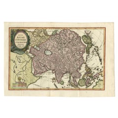

Antique Map of Continental Asia, with Japan, Arabia, India, Russia, etc c.1702
Located in Langweer, NL
We offer a wide range of authentic antique maps for any budget.
Paper
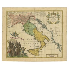

Unusual Benedictine Map of Italy, Showing Various States of the Church, C.1745
Located in Langweer, NL
We offer a wide range of authentic antique maps for any budget.
Paper
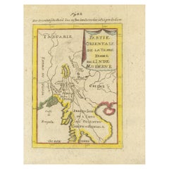
Antique Map of India and the Gulf of Bengal by Mallet, c.1686
Located in Langweer, NL
We offer a wide range of authentic antique maps for any budget.
Paper

$149Sale Price|20% Off
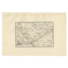
Antique Map of the Region of Twente, in The East of The Netherlands, 1884
Located in Langweer, NL
We offer a wide range of authentic antique maps for any budget.
Paper

Old Map of the Moluccas and Part of Sulawesi Indonesia by Vandermaelen, c 1825
Located in Langweer, NL
We offer a wide range of authentic antique maps for any budget.
Paper
$130Sale Price|20% Off
Antique Map of the Township of Vries in the Dutch Province of Drenthe, 1865
Located in Langweer, NL
We offer a wide range of authentic antique maps for any budget.
Paper

$502Sale Price|20% Off
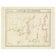
Detailed Antique Map of a Portion of Borneo and Sulawesi in Indonesia, c.1825
Located in Langweer, NL
We offer a wide range of authentic antique maps for any budget.
Paper