Items Similar to Antique Map of the City of Algiers and Surroundings in Northern Africa, 1773
Want more images or videos?
Request additional images or videos from the seller
1 of 5
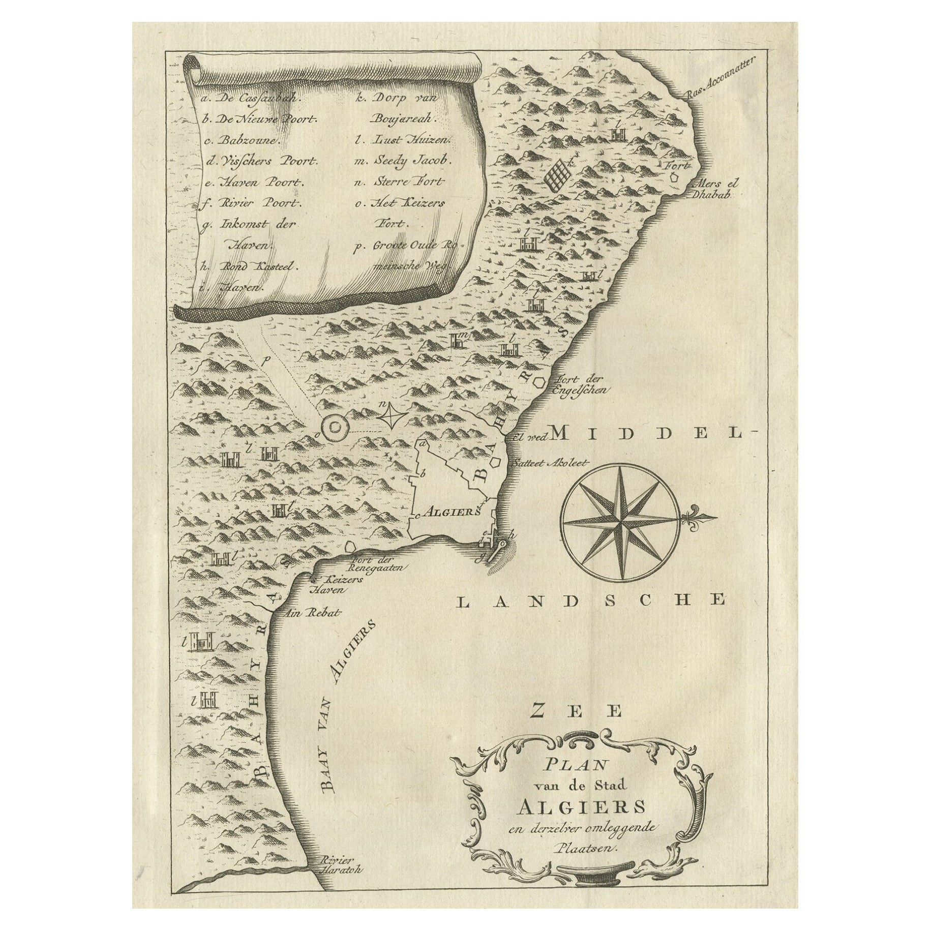
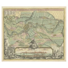
Antique Map of the City of Algiers and Surroundings in Northern Africa, 1773
About the Item
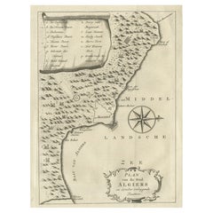
Antique print titled 'Plan van de Stad Algiers'. Old map of Algiers, also depicting surrounding cities and the Bay of Algiers. Originates from the first Dutch editon of an interesting travel account of Northern Africa titled 'Reizen en Aanmerkingen door en over Barbaryen en het Ooste'.
Algiers (Arabic: ????????; Berber: Dzayer; French: Alger) is the capital and largest city of Algeria. The city's population in 2011 was estimated to be around 3,500,000. An estimate puts the population of the larger metropolitan city to be around 5,000,000. Algiers is located on the Mediterranean Sea and in the north-central portion of Algeria. Algiers is situated on the west side of a bay of the Mediterranean Sea. The modern part of the city is built on the level ground by the seashore; the old part, the ancient city of the deys, climbs the steep hill behind the modern town and is crowned by the Casbah or citadel, 122 metres (400 ft) above the sea. The casbah and the two quays form a triangle.
Artists and Engravers: Author: T. Shaw. Translated by P. Boddaert and published by J. van Schoonhoven.
Condition: Very good, general age-related toning. Please study image carefully.
Date: 1773
Overall size: 20.5 x 26.5 cm.
Image size: 16 x 22 cm.
We sell original antique maps to collectors, historians, educators and interior decorators all over the world. Our collection includes a wide range of authentic antique maps from the 16th to the 20th centuries. Buying and collecting antique maps is a tradition that goes back hundreds of years. Antique maps have proved a richly rewarding investment over the past decade, thanks to a growing appreciation of their unique historical appeal. Today the decorative qualities of antique maps are widely recognized by interior designers who appreciate their beauty and design flexibility. Depending on the individual map, presentation, and context, a rare or antique map can be modern, traditional, abstract, figurative, serious or whimsical. We offer a wide range of authentic antique maps for any budget.
- Dimensions:Height: 10.44 in (26.5 cm)Width: 8.08 in (20.5 cm)Depth: 0 in (0.01 mm)
- Materials and Techniques:
- Period:
- Date of Manufacture:1773
- Condition:
- Seller Location:Langweer, NL
- Reference Number:
About the Seller
5.0
Platinum Seller
These expertly vetted sellers are 1stDibs' most experienced sellers and are rated highest by our customers.
Established in 2009
1stDibs seller since 2017
1,916 sales on 1stDibs
Typical response time: <1 hour
- ShippingRetrieving quote...Ships From: Langweer, Netherlands
- Return PolicyA return for this item may be initiated within 14 days of delivery.
More From This SellerView All
- Old Map of Algiers, with Surrounding Cities and the Bay of Algiers, 1773Located in Langweer, NLAntique print titled 'Plan van de Stad Algiers'. Old map of Algiers, also depicting surrounding cities and the Bay of Algiers. Originates from the first Dutch editon of an intere...Category
Antique 1770s Maps
MaterialsPaper
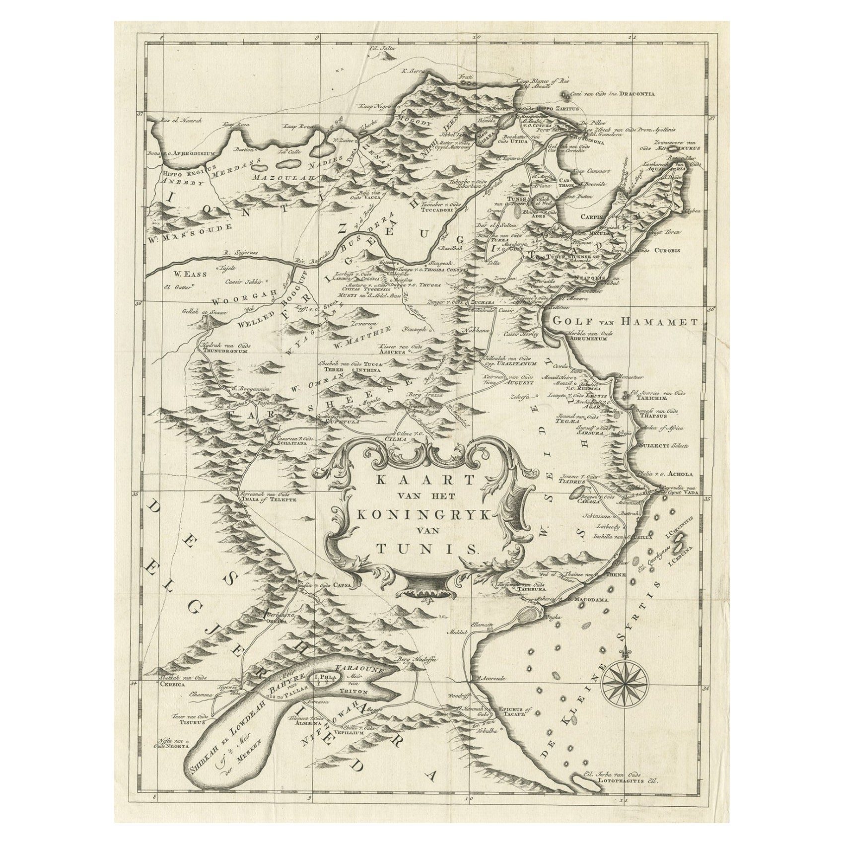
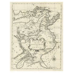
- Antique Map of the Kingdom of Tunisia, Africa, 1773Located in Langweer, NLAntique map titled 'Kaart van het Koningryk van Tunis'. Old map of the Kingdom of Tunisia. Originates from the first Dutch editon of an interesting travel account of Northern Africa ...Category
Antique 18th Century Maps
MaterialsPaper
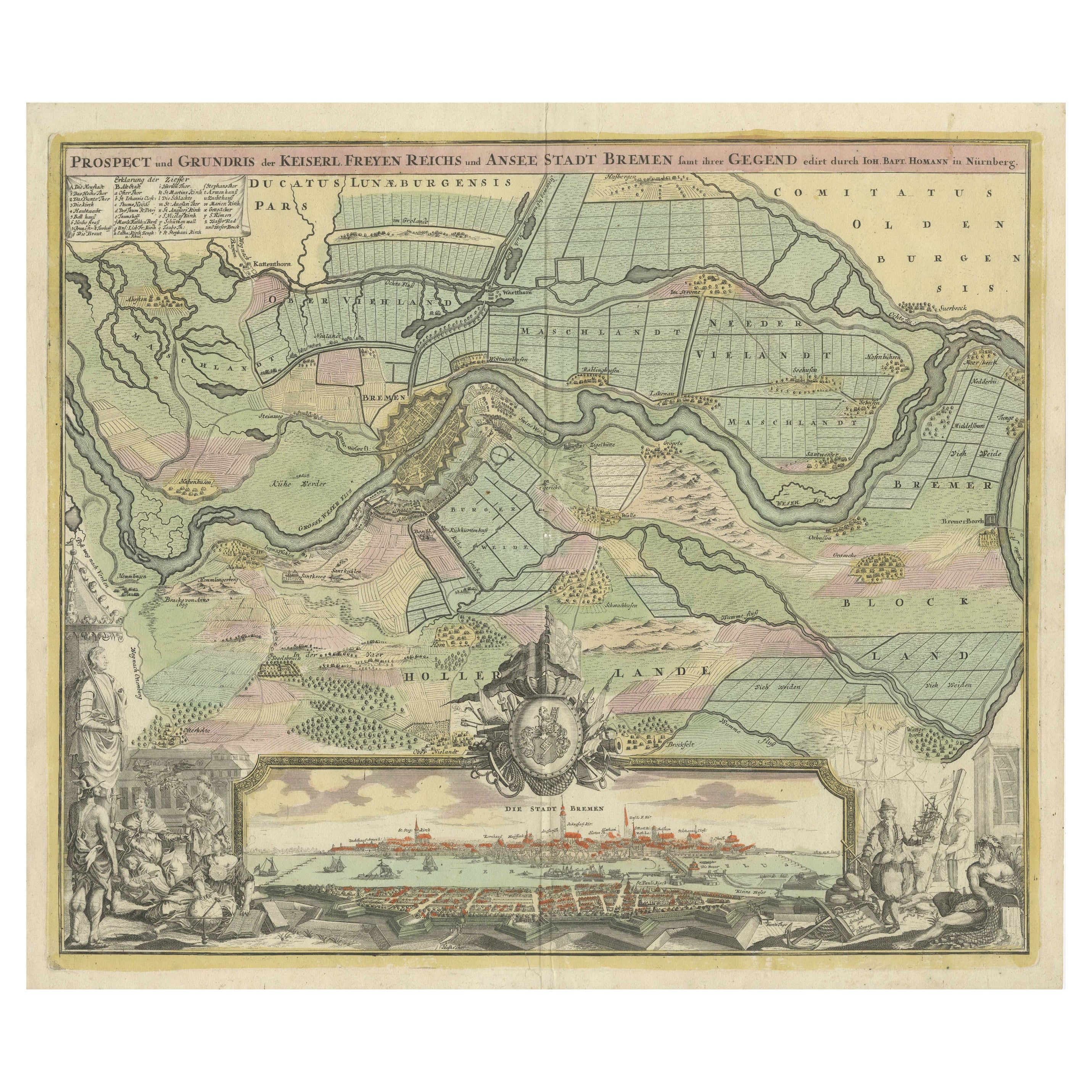
- Large Antique Map of the City of Bremen and Surroundings, GermanyLocated in Langweer, NLOriginal antique map titled 'Prospect und Grundris der Keiserl Freyen Reichs und Ansee Stadt Bremen (..)'. This is a superb chart of the city of Bremen and the surrounding small vill...Category
Antique Early 18th Century Maps
MaterialsPaper
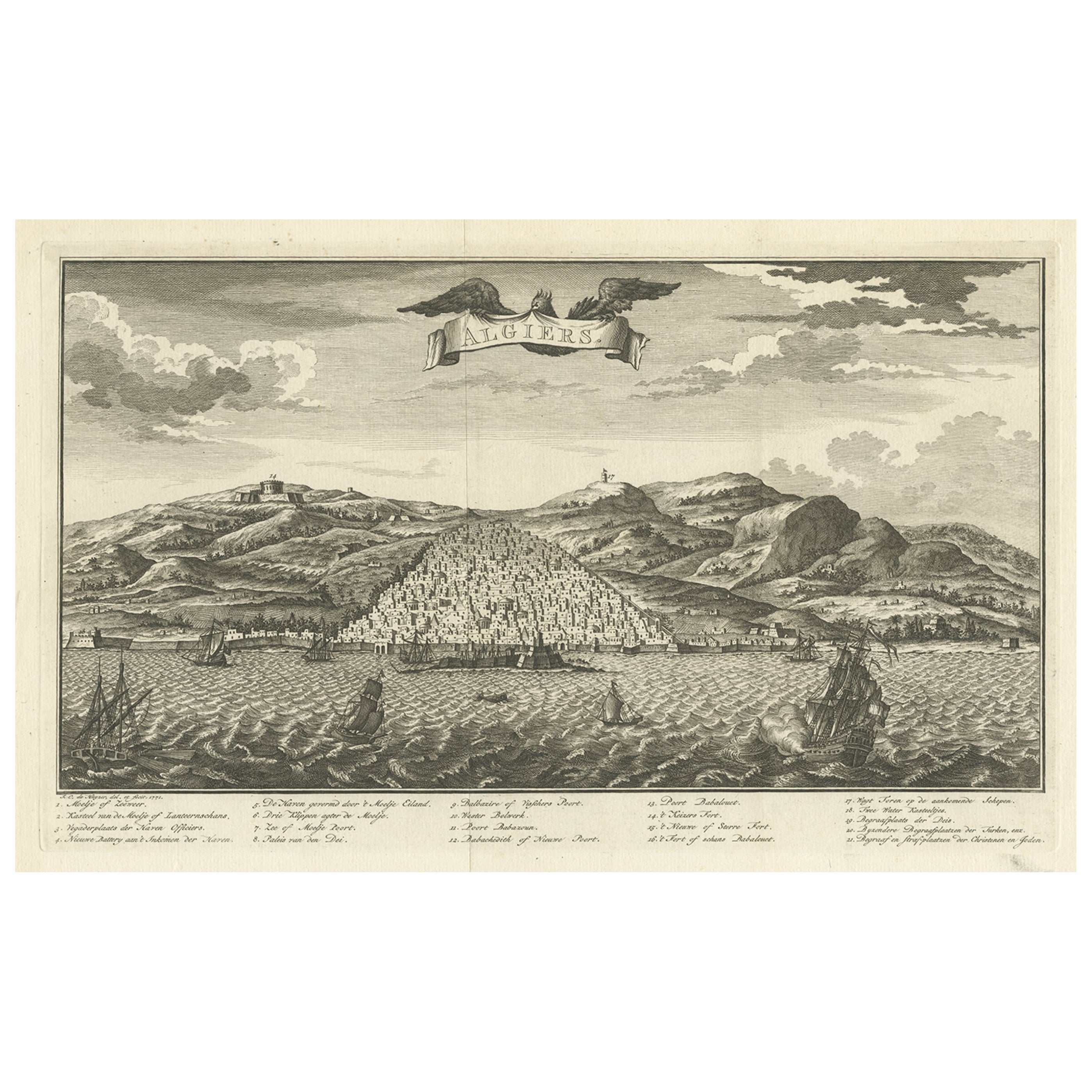
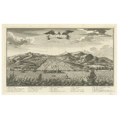
- Original Antique Engraving of Algiers in Algeria, 1773Located in Langweer, NLAntique print titled 'Algiers'. Old print with a view of Algiers, Algeria. With Dutch legend. Originates from the first Dutch editon of an interesting travel account of Northern Afri...Category
Antique 18th Century Prints
MaterialsPaper
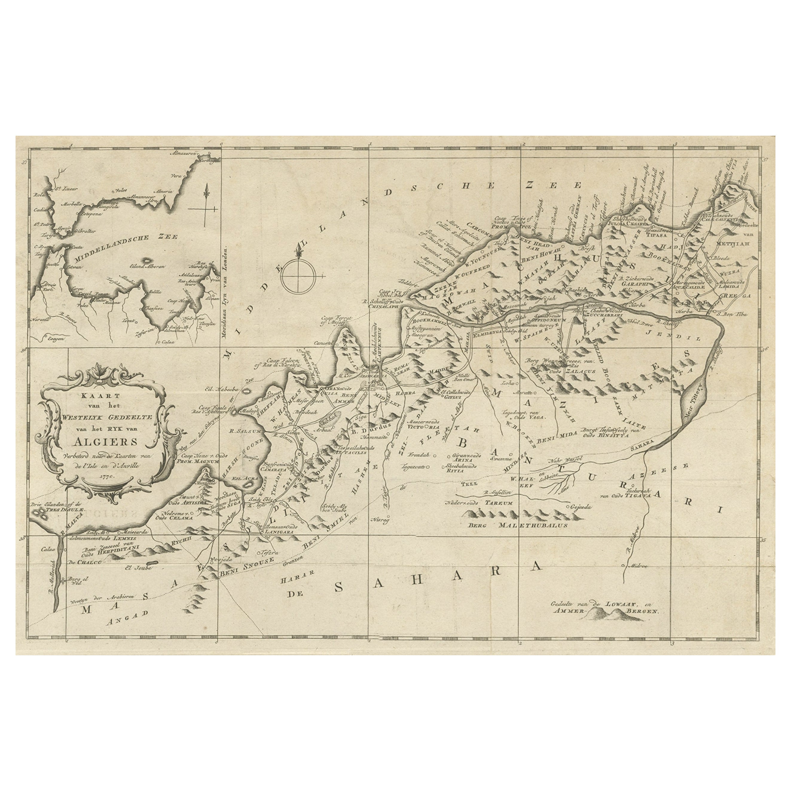
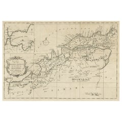
- Old Map of the Western Region of the Kingdom of Algiers, Algeria, 1773Located in Langweer, NLAntique map titled 'Kaart van het Westelyk Gedeelte van het Ryk van Algiers'. Old map of the western region of the Kingdom of Algiers, Algeria. Originates from the first Dutch ed...Category
Antique 1770s Maps
MaterialsPaper
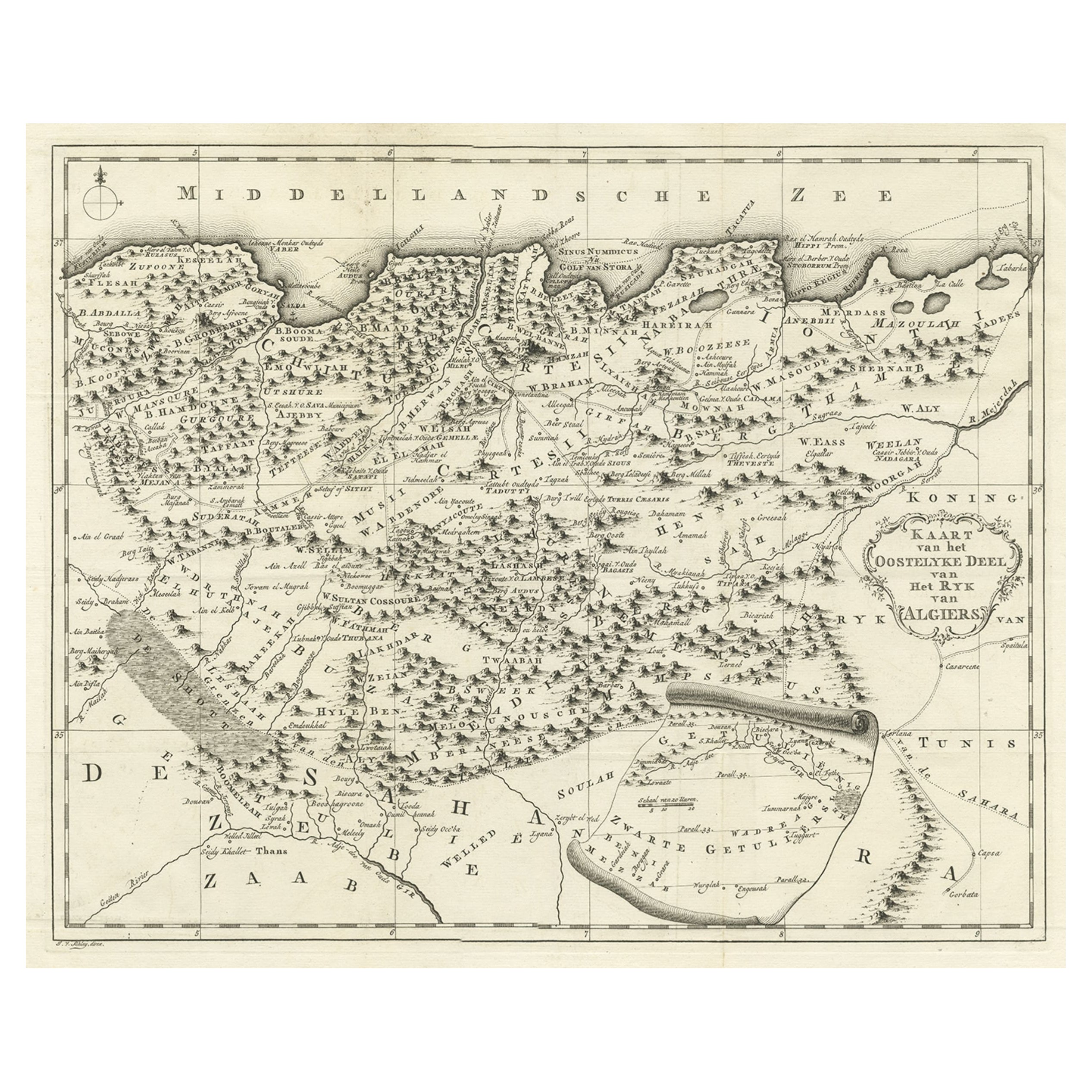
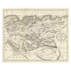
- Old Map of the Eastern Region of the Kingdom of Algiers, Algeria, 1773Located in Langweer, NLAntique map titled 'Kaart van het Oostelyke Deel van het Ryk van Algiers'. Old map of the eastern region of the Kingdom of Algiers, Algeria. Originates from the first Dutch edito...Category
Antique 1770s Maps
MaterialsPaper
You May Also Like
- Original Antique Map of South Africa, Arrowsmith, 1820Located in St Annes, LancashireGreat map of South Africa. Drawn under the direction of Arrowsmith. Copper-plate engraving. Published by Longman, Hurst, Rees, Orme and Br...Category
Antique 1820s English Maps
MaterialsPaper
- Italian Parchment Map of the City of Pisa Dated, 1640By Matthäus Merian the ElderLocated in Roma, ITAn antique map of the Tuscan city of Pisa engraved for The 'Itinerarium Italiæ Nov-antiquæ' by Matthäus Merian the Elder and printed in 1640....Category
Antique 1640s Italian Maps
MaterialsPaper
- Italian Parchment Map of the City of Lucca Dated 1640By Matthäus Merian the ElderLocated in Roma, ITAn antique map of the Tuscan city of Lucca engraved for The 'Itinerarium Italiæ Nov-antiquæ' by Matthäus Merian the Elder and printed in 1640...Category
Antique 1640s Italian Maps
MaterialsParchment Paper, Paper
- 1840 Map of the City of Washington Published by William M. MorrisonLocated in Colorado Springs, COThis map, printed in 1840, is a detailed representation of Washington, D.C. in the mid-19th century. The map shows block numbers, wards, and government buildings as well as details o...Category
Antique 1840s American Federal Maps
MaterialsPaper
- 1861 Topographical Map of the District of Columbia, by Boschke, Antique MapLocated in Colorado Springs, COPresented is an original map of Albert Boschke's extremely sought-after "Topographical Map of the District of Columbia Surveyed in the Years 1856 ...Category
Antique 1860s American Historical Memorabilia
MaterialsPaper
- Original Antique Map / City Plan of Brussels by Tallis, circa 1850Located in St Annes, LancashireGreat map of Brussels. Steel engraving. Published by London Printing & Publishing Co. (Formerly Tallis), C.1850 Free shipping.Category
Antique 1850s English Maps
MaterialsPaper


Recently Viewed
View AllMore Ways To Browse
Northern French Furniture
20th Century Africa Collectibles
Large Map Of The World
African Crown
Ancient Maps
Ancient Map
Population Of Antique
18th Century African
Antique Level Collectors
Antique Maps Africa
Antique Map Africa
Antique Africa Map
Antique African Map
Africa Antique Map
Antique Africa Maps
Antique African Maps
Africa Map Antique
Antique Map Of Africa