Items Similar to Antique Map of the Region of Athens from a German Atlas of 1893


Want more images or videos?
Request additional images or videos from the seller
1 of 5
Antique Map of the Region of Athens from a German Atlas of 1893
About the Item
Antique map titled 'Umgebung von Athen'. Original antique map of the region of Athens, Greece. This map originates from the 5th edition of 'Meyers Konversations-Lexikon', published 1893 to 1897.
Artists and Engravers: Meyers Konversations-Lexikon or Meyers Lexikon was a major encyclopedia in the German language that existed in various editions, and by several titles, from 1839 to 1984, when it merged with the Brockhaus Enzyklopädie.
Condition: Good, general age-related toning. Few tiny defects in margins, blank verso. Please study image carefully.
Date: c.1893
Overall size: 24 x 15.5 cm
Image size: 19.5 x 12.5 cm
We sell original antique maps to collectors, historians, educators and interior decorators all over the world. Our collection includes a wide range of authentic antique maps from the 16th to the 20th centuries. Buying and collecting antique maps is a tradition that goes back hundreds of years. Antique maps have proved a richly rewarding investment over the past decade, thanks to a growing appreciation of their unique historical appeal. Today the decorative qualities of antique maps are widely recognized by interior designers who appreciate their beauty and design flexibility. Depending on the individual map, presentation, and context, a rare or antique map can be modern, traditional, abstract, figurative, serious or whimsical. We offer a wide range of authentic antique maps for any budget.
- Dimensions:Height: 6.11 in (15.5 cm)Width: 9.45 in (24 cm)Depth: 0 in (0.01 mm)
- Materials and Techniques:
- Period:
- Date of Manufacture:circa 1893
- Condition:
- Seller Location:Langweer, NL
- Reference Number:
About the Seller
5.0
Platinum Seller
These expertly vetted sellers are 1stDibs' most experienced sellers and are rated highest by our customers.
Established in 2009
1stDibs seller since 2017
1,933 sales on 1stDibs
Typical response time: <1 hour
- ShippingRetrieving quote...Ships From: Langweer, Netherlands
- Return PolicyA return for this item may be initiated within 14 days of delivery.
More From This SellerView All
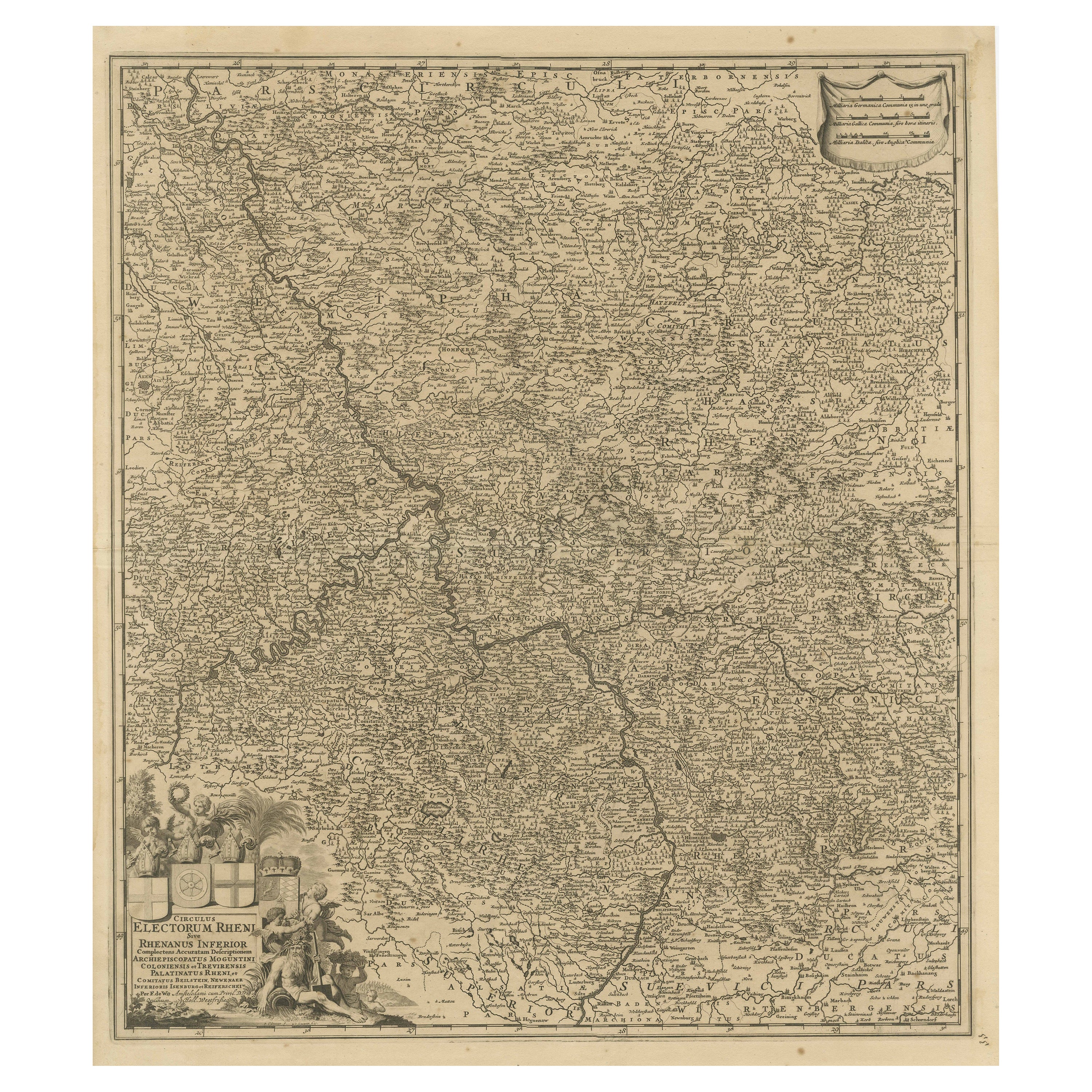
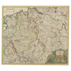
- Antique Map of the Niederrhein region, GermanyLocated in Langweer, NLAntique map titled 'Circulus Electorum Rheni sive Rhenanus Inferior (..)'. Original antique map of the Niederrhein region, Germany. By F. de Wit, circa 1690. Frederick de Wit (1629-...Category
Antique Late 17th Century Maps
MaterialsPaper
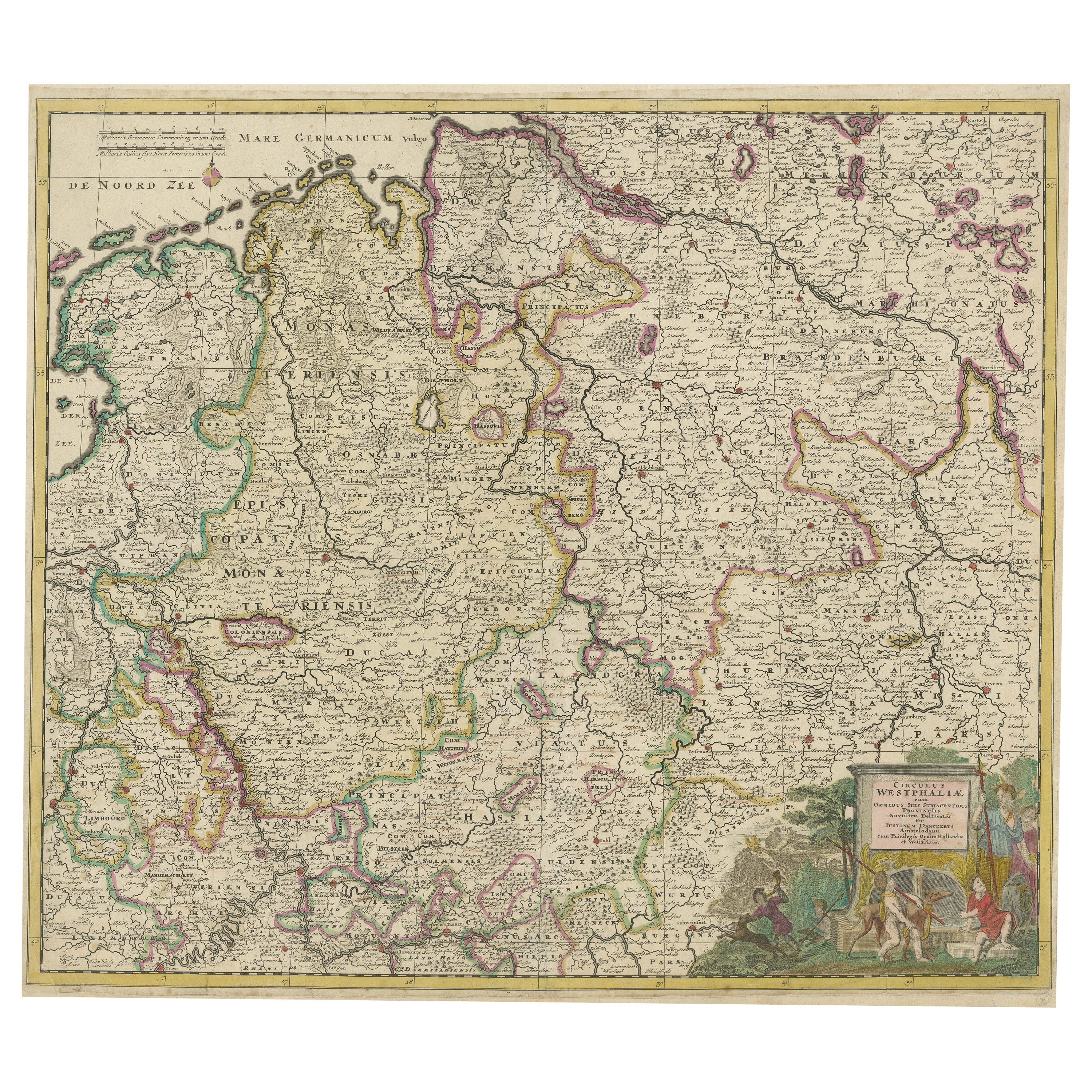
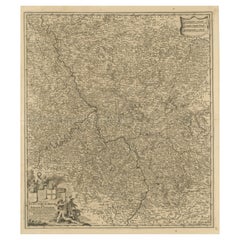
- Antique Map of the Westphalia region of GermanyLocated in Langweer, NLAntique map titled 'Circulus Westphaliae (..)'. Original old map of the Westphalia region, Germany. Published by Justus Danckerts, circa 1696. Justus Danckerts I (11 November 1635 ...Category
Antique Late 17th Century Maps
MaterialsPaper
- Antique Map of the Region of Oldenburg, GermanyBy Willem BlaeuLocated in Langweer, NLAntique map titled 'Oldenburg Comitatus'. Detailed old map of Oldenburg, Germany. The map also shows Bremen and the Jade Bight. Published by W. Blaeu, circa 1640. Willem Jansz. Blaeu...Category
Antique Mid-17th Century Maps
MaterialsPaper
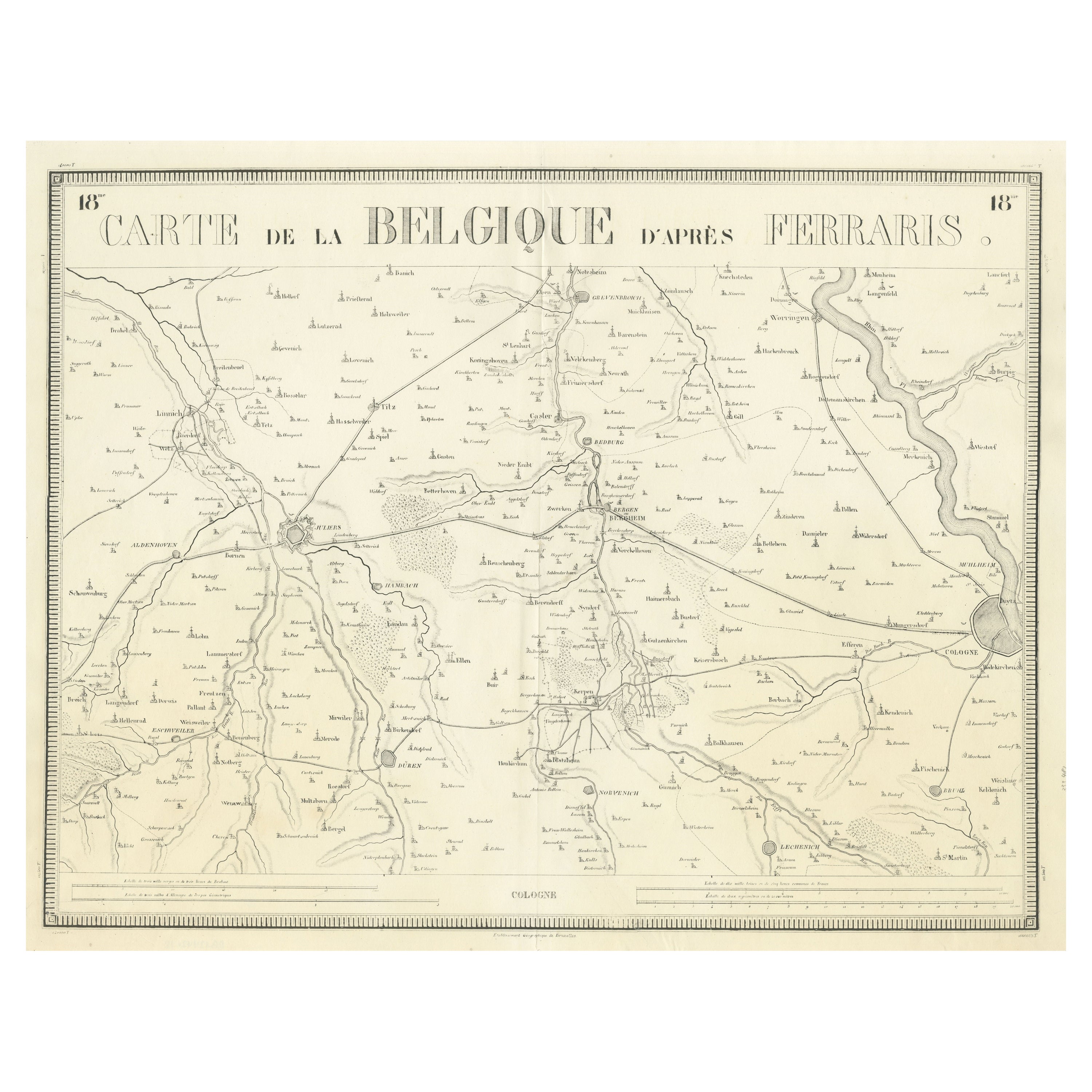
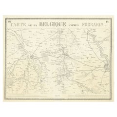
- Antique Map of the Region near Cologne, GermanyLocated in Langweer, NLAntique map titled 'Carte de la Belgique d'après Ferraris'. Original antique map of the region near Cologne, Germany. Cologne is the largest city of the German western state of North...Category
Antique Mid-19th Century Maps
MaterialsPaper
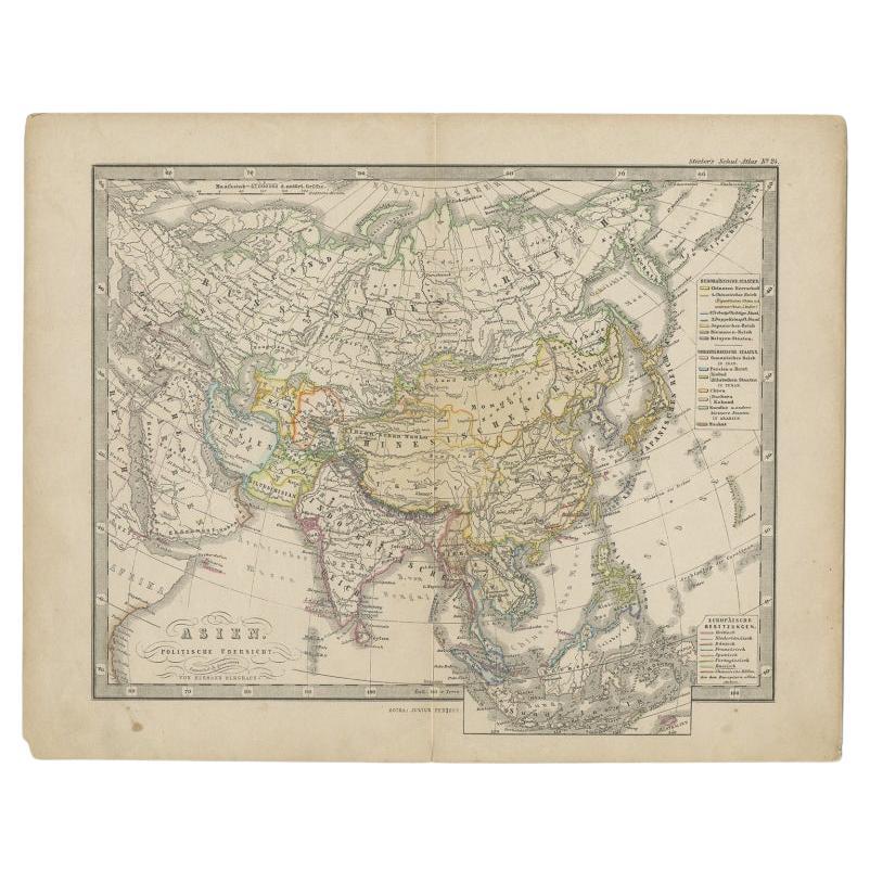
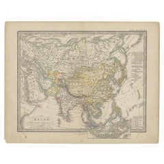
- Antique Map of the Asian Continent from a German School Atlas, 1862Located in Langweer, NLAntique map titled 'Asien Politische Ubersicht'. Old map of the Asian continent. Originates from Stieler's 'Schul-Atlas'. Artists and Engravers: Published by Johan Georg Justus Per...Category
Antique 19th Century Maps
MaterialsPaper
- Antique Map of Asia from a German School Atlas, c.1870Located in Langweer, NLAntique map titled 'Asien'. Old map of the Asian continent. This map originates from 'H. Kiepert's Kleiner Atlas der Neueren Geographie für Schule und Haus'. Artists and Engravers:...Category
Antique 19th Century Maps
MaterialsPaper


You May Also Like
- Antique German Hartleben's Volks Atlas Book World MapsLocated in Seguin, TXAntique circa 1900 A. Hartleben's Volks-Atlas. Published by A. Hartleben's, Germany. Folio hardcover with decorated olive cloth binding and brown leather spine. Gilt title to spine...Category
Early 20th Century German Aesthetic Movement Maps
MaterialsPaper
- 17th Century Hand-Colored Map of a Region in West Germany by JanssoniusBy Johannes JanssoniusLocated in Alamo, CAThis attractive highly detailed 17th century original hand-colored map is entitled "Archiepiscopatus Maghdeburgensis et Anhaltinus Ducatus cum terris adjacentibus". It was published ...Category
Antique Mid-17th Century Dutch Maps
MaterialsPaper
- 1594 Maurice Bouguereau Map of the Region Limoges, France, Ric0015Located in Norton, MA1594 Maurice Bouguereau map of the region Limoges, France, entitled "Totivs Lemovici et Confinium Pro Uinciarum Quantum ad Dioecefin Lemo Uicenfen Fpectant," Hand Colored Ric0015 Jean IV Le Clerc...Category
Antique 16th Century Dutch Maps
MaterialsPaper
- Museum Replica Fragment of a Marble Votive Relief from the Acropolis of AthensLocated in Nuernberg, DEOffered is a reproduction of a relief piece made from a cast of the original marble relief and hand finished by skilled artisans to ensure its accuracy and authenticity. It is a beautiful representation of the original and gives an insight into the culture of ancient Greece. The Certificate of Authenticity certifies that the marble votive...Category
Vintage 1960s Greek Classical Greek Decorative Art
MaterialsPlaster
- "The United States from the Latest Authorities" Antique Wall Map, 1835Located in Colorado Springs, COThis is a 1835 map of “The United States from the Latest Authorities” by Ezra Strong. A hand-colored engraved wall map of the eastern half of the United States, this map has a large inset of the "Oregon District" and several engraved city views and two portraits. The primary map extends to Mexico Texas and the Missouri Territory, showing the course of the Missouri River to Ft. Mandan and Old Ft. Mandan, and noting many forts along the river. The territories to the east of Missouri Territory are separately delineated as Sioux District and Huron District. The western details of the map are very good for a map of this time period, with many Native American settlements, villages, forts and other details noted. The map is bordered with vignettes of Boston, New York, Philadelphia, Hartford, Cincinnati, and Baltimore. Each vignette notes the date settled, primary settler, and the population as of 1830. Two portraits of LaFayette and George Washington are presented in full length with related biographical information. A large inset map at lower right shows the Oregon District, centered on the Columbia River and extending to the Rocky Mountains. This is one of the earliest commercial appearances of a separate map of Oregon...Category
Antique 1830s American Maps
MaterialsPaper
- 1861 Topographical Map of the District of Columbia, by Boschke, Antique MapLocated in Colorado Springs, COPresented is an original map of Albert Boschke's extremely sought-after "Topographical Map of the District of Columbia Surveyed in the Years 1856 ...Category
Antique 1860s American Historical Memorabilia
MaterialsPaper


Recently Viewed
View AllMore Ways To Browse
19th Century German Collectibles
Athens Furniture
Map Greece
Greek Map
Map Of Greece
Historical Maps Germany
Antique Maps Greece
Antique Map Greece
Antique Greek Map
Antique Greece Map
Antique Maps Of Greece
Antique Map Of Greece
Space Map
Set Of Maps
Antique World Globe
Antique World Globes
World Globes Antique
Antique Rollers