Items Similar to Antique Map of the Passage Between the Atlantic and Pacific Oceans, circa 1753


Want more images or videos?
Request additional images or videos from the seller
1 of 6
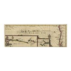
Antique Map of the Passage Between the Atlantic and Pacific Oceans, circa 1753
About the Item
Antique print, titled: 'Carte du Detroit de le Maire (…)' - This chart illustrates the important passage between the Atlantic and Pacific oceans. Jacob Le Maire and Willem Schouten discovered the strait in 1616, which was a much less treacherous route than the Strait of Magellan, and opening up a new trade route for the Dutch. The map is adorned with a fine compass rose.Source unknown, to be determined.
Artists and Engravers: Made by 'Nicolas Bellin' after an anonymous artist. Jacques Nicolas Bellin (1703 - 1772) was a French hydrographer, geographer, and member of the French intellectual group called the philosophes. Bellin was born in Paris. He was hydrographer of France's hydrographic office, member of the Academie de Marine and of the Royal Society of London. Over a 50 year career, he produced a large number of maps of particular interest to the Ministere de la Marine.
Condition: Good, given age. Some foxing, mainly in the margins. Edges slightly browned. Original folds as issued. General age-related toning and/or occasional minor defects from handling. Please study scan carefully.
Date: c.1753
Overall size: 32.5 x 24.4 cm.
Image size: 27.5 x 19.4 cm.
We sell original antique maps to collectors, historians, educators and interior decorators all over the world. Our collection includes a wide range of authentic antique maps from the 16th to the 20th centuries. Buying and collecting antique maps is a tradition that goes back hundreds of years. Antique maps have proved a richly rewarding investment over the past decade, thanks to a growing appreciation of their unique historical appeal. Today the decorative qualities of antique maps are widely recognized by interior designers who appreciate their beauty and design flexibility. Depending on the individual map, presentation, and context, a rare or antique map can be modern, traditional, abstract, figurative, serious or whimsical. We offer a wide range of authentic antique maps for any budget.
- Dimensions:Height: 9.61 in (24.4 cm)Width: 12.8 in (32.5 cm)Depth: 0 in (0.01 mm)
- Materials and Techniques:
- Period:
- Date of Manufacture:circa 1753
- Condition:Condition: Good, given age. Some foxing, mainly in the margins. Edges slightly browned. Original folds as issued. General age-related toning and/or occasional minor defects from handling. Please study scan carefully.
- Seller Location:Langweer, NL
- Reference Number:
About the Seller
5.0
Platinum Seller
These expertly vetted sellers are 1stDibs' most experienced sellers and are rated highest by our customers.
Established in 2009
1stDibs seller since 2017
1,922 sales on 1stDibs
Typical response time: <1 hour
- ShippingRetrieving quote...Ships From: Langweer, Netherlands
- Return PolicyA return for this item may be initiated within 14 days of delivery.
More From This SellerView All
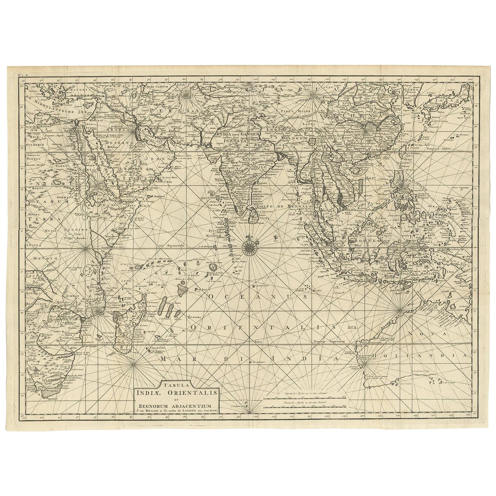
- Antique Map of South East Asia, Australia and the Indian Ocean, 1726By F. ValentijnLocated in Langweer, NLAntique map titled 'Tabula Indiae Orientalis'. Beautiful detailed map of Australia, Southeast Asia and the Indian Ocean. The map features a fine depiction of the outlines of the western two-thirds of Australia, based on the discoveries of explorers working for the Dutch East India Company (the VOC). These include Willem Jansz's discoveries in the Gulf of Carpentaria in 1606; the encounters of Dirk...Category
Antique Mid-18th Century Dutch Maps
MaterialsPaper
- Antique Map of the Pacific Ocean by Renneville, 1725Located in Langweer, NLRare map of the Southern Pacific, illustrating Le Maire's tracks, extending from the La Maire Straits to Nova Guinea, with a large inset of the northern Coastline of New Guinea and a...Category
Antique 18th Century Maps
MaterialsPaper
- Antique Map of the Pacific Ocean by Anson, 1765Located in Langweer, NLAntique map titled 'Carte de la Mer du Sud ou Mer Pacifique - Kaart van de Zuyd-Zee of stille oceaan (..)'. Nautical chart of the Pacific Ocean depicting the trade routes used by Spanish Galleons from Acapulco in Mexico to Manila in the Philippines. In particular this chart depicts the voyages of the Spanish Nostra Seigniora de Cabadonga and the British Navy Commodore George Anson. Anson succeed in capturing the Spanish treasure...Category
Antique 18th Century Maps
MaterialsPaper
- Antique Map of the Pacific Ocean by Rienzi, 1836Located in Langweer, NLAntique map titled 'Mélanésie'. Map of the Pacific ocean around Australia, including Java, Timor, the Solomon Islands and New Zealand. This print or...Category
Antique 19th Century Maps
MaterialsPaper
- Antique Map of the Pacific Ocean by Renneville, 1702Located in Langweer, NLAntique map, untitled. A map of the Pacific Ocean, with the coast of Peru in the right edge and the outline of New Guinea in the left edge. In betwe...Category
Antique 18th Century Maps
MaterialsPaper
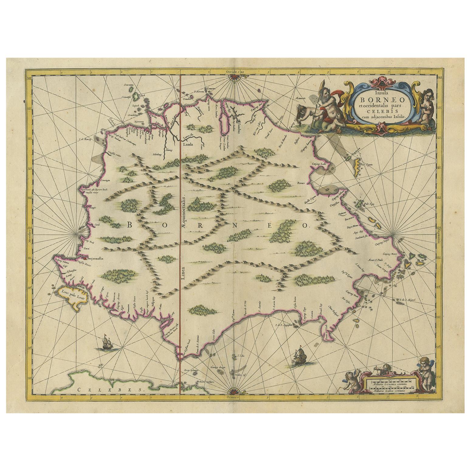
- Antique Map of the Island of Borneo by Janssonius, circa 1650Located in Langweer, NLAntique map titled 'Insula Borneo et Occidentalis pars Celebis cum adjacentibus Insulis'. Rare sea chart of the island of Borneo. Published by J. Janssonius, circa 1650.Category
Antique Mid-17th Century Maps
MaterialsPaper


You May Also Like
- Large Original Antique Map of The Pacific Ocean, Fullarton, C.1870Located in St Annes, LancashireGreat map of The Pacific Ocean From the celebrated Royal Illustrated Atlas Lithograph by Swanston. Original color. Published by Fullarton,...Category
Antique 1870s Scottish Maps
MaterialsPaper
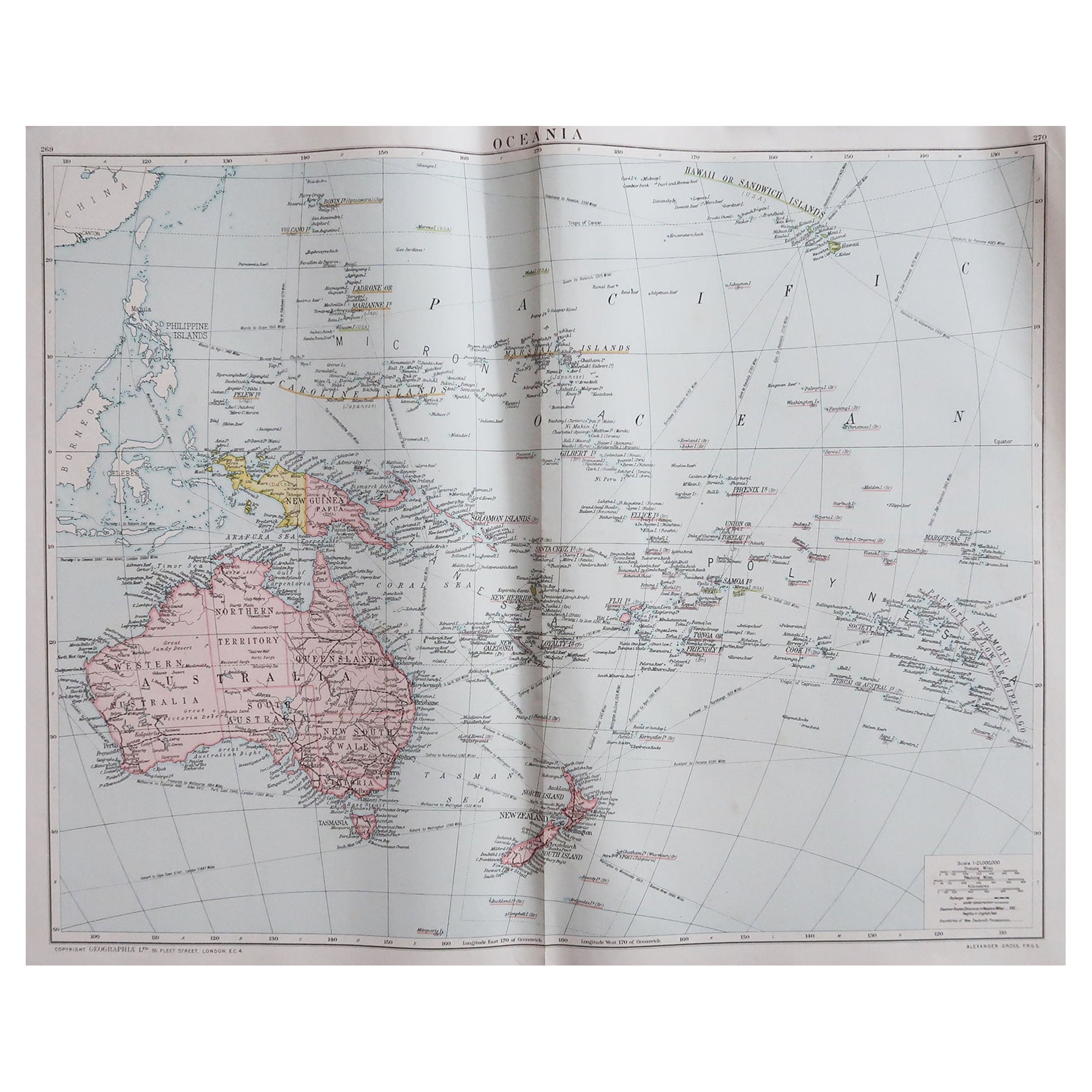
- Large Original Vintage Map of The South Pacific, circa 1920Located in St Annes, LancashireGreat map of The South Pacific Original color. Good condition / repairs to minor edge tears on top edge Published by Alexander Gross Unf...Category
Vintage 1920s English Edwardian Maps
MaterialsPaper
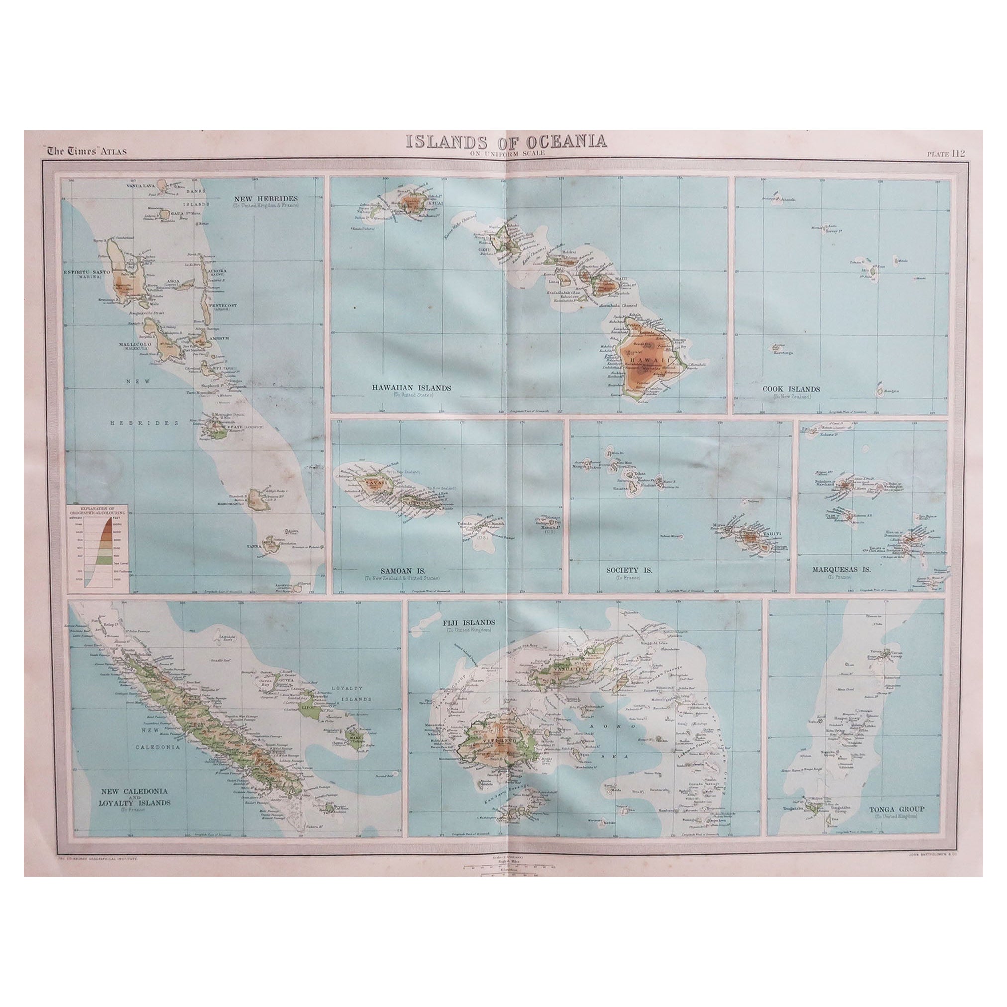
- Large Original Vintage Map of The Pacific Islands Including HawaiiLocated in St Annes, LancashireGreat map of The Pacific Islands Unframed Original color By John Bartholomew and Co. Edinburgh Geographical Institute Published, circa 1...Category
Vintage 1920s British Maps
MaterialsPaper
- Original Antique Map of The United States of America, circa 1890Located in St Annes, LancashireGreat map of the USA By The Stanford's Geographical Establishment Original colour Unframed.Category
Antique 1890s English Victorian Maps
MaterialsPaper
- Large Original Antique Map of the World, Fullarton, circa 1870Located in St Annes, LancashireGreat map of the World. From the celebrated Royal Illustrated Atlas Lithograph. Original color. Published by Fullarton, Edinburgh, circa 1870. Unframed.Category
Antique 1870s Scottish Maps
MaterialsPaper
- Large Original Antique Map of The Environs of Dublin, Ireland, circa 1880Located in St Annes, LancashireGreat map of The Environs of Dublin Published circa 1880 Unframed Free shipping.Category
Antique 1880s Scottish Maps
MaterialsPaper


Recently Viewed
View AllMore Ways To Browse
Pacific Modern
Toner Chart
Antique Compass London
Antique Ocean Prints
Du Passage
Carte Paris
Antique Marine Prints
Pacific Map
Antique Marine Maps
Antique Furniture Detroit
Large Map Of London
Atlantic Ocean Map
Large Antique Map Of Paris
Map New Holland
Pacific Ocean Antique Map
Large Maps Of Paris
Used Marine Compass
Marine Compass