Items Similar to Antique Map of the Harbour of Praia, Santiago Island, Cape Verde, c.1750


Want more images or videos?
Request additional images or videos from the seller
1 of 6
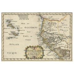
Antique Map of the Harbour of Praia, Santiago Island, Cape Verde, c.1750
About the Item
Antique map titled 'A Draught of ye Harbour of Praya in the Island St. Jago (..)'. Uncommon map showing the harbour of Praia on Santiago Island, Cape Verde. Source unknown, to be determined.
Praia Harbor (Portuguese: Porto da Praia) is the port of the city of Praia in the southern part of the island of Santiago, Cape Verde. It is situated in a natural bay of the Atlantic Ocean. Since the latest modernisation in 2014, it has 2 long quays, 3 shorter quays, a quay for fishing boats with fish processing installations, 2 container parks, 2 roll-on/roll-off ramps and a passenger terminal. The total length of the quays is 863 m, and the maximum depth is 13.5 m.The port of Praia played an important role in the colonisation of Africa and South America by the Portuguese. With 817,845 metric tonnes of cargo and 85,518 passengers handled (2017), it is the second busiest port of Cape Verde, after Porto Grande (Mindelo).
The bay of Praia lies between the headlands Ponta Temerosa and Ponta das Bicudas. The islet Ilhéu de Santa Maria lies in the bay, west of the port. The river Ribeira da Trindade empties into the bay, between the city centre (Plateau) and the port. Directly north of the port is the city subdivision Achada Grande Frente.
Artists and Engravers: Made by 'Clark'.
Condition: Good, given age. Slight offsetting. General age-related toning and/or occasional minor defects from handling. Please study image carefully.
Date: c.1750
Overall size: 21.2 x 33.5 cm.
Image size: 19.7 x 31.3 cm.
We sell original antique maps to collectors, historians, educators and interior decorators all over the world. Our collection includes a wide range of authentic antique maps from the 16th to the 20th centuries. Buying and collecting antique maps is a tradition that goes back hundreds of years. Antique maps have proved a richly rewarding investment over the past decade, thanks to a growing appreciation of their unique historical appeal. Today the decorative qualities of antique maps are widely recognized by interior designers who appreciate their beauty and design flexibility. Depending on the individual map, presentation, and context, a rare or antique map can be modern, traditional, abstract, figurative, serious or whimsical. We offer a wide range of authentic antique maps for any budget
- Dimensions:Height: 13.19 in (33.5 cm)Width: 8.35 in (21.2 cm)Depth: 0 in (0.01 mm)
- Materials and Techniques:
- Period:
- Date of Manufacture:circa 1750
- Condition:Condition: Good, given age. Slight offsetting. General age-related toning and/or occasional minor defects from handling. Please study image carefully.
- Seller Location:Langweer, NL
- Reference Number:
About the Seller
5.0
Platinum Seller
These expertly vetted sellers are 1stDibs' most experienced sellers and are rated highest by our customers.
Established in 2009
1stDibs seller since 2017
1,919 sales on 1stDibs
Typical response time: <1 hour
- ShippingRetrieving quote...Ships From: Langweer, Netherlands
- Return PolicyA return for this item may be initiated within 14 days of delivery.
More From This SellerView All
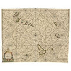
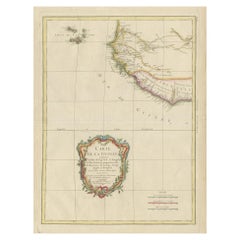
- Original Antique Map of the Cape Verde Islands, 1746Located in Langweer, NLAntique map titled 'Carte Des Isles Du Cap Verd.' Original antique map of the Cape Verde Islands. Decorative cartouche and compass rose. Extends from Isle d...Category
Antique 18th Century Maps
MaterialsPaper
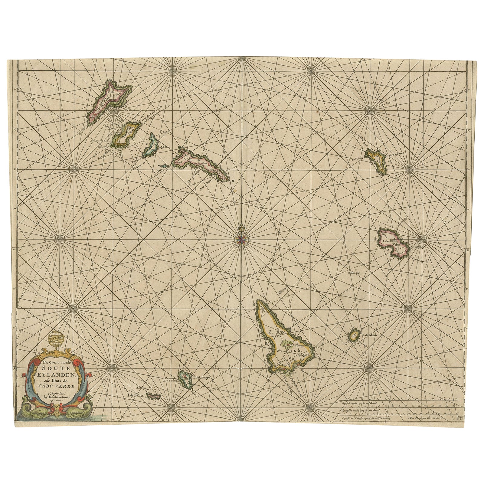
- Antique Map of the Cape Verde Islands, Africa, ca.1670Located in Langweer, NLAntique map titled 'Pascaert van de Soute Eylanden ofte Ilhas de Cabo Verde'. This map depicts the Cape Verde Islands (Africa). Islands titled 'Ile de B...Category
Antique 1670s Maps
MaterialsPaper
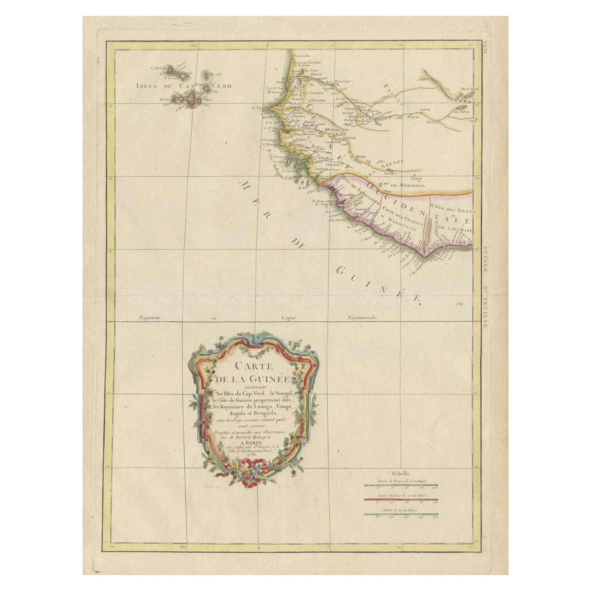
- Antique Map of the Coast of Guinea and the Cape Verde IslandsLocated in Langweer, NLAntique map titled 'Carte de la Guinée (..)'. This map was originally part of a 2 sheet larger map of Eastern Africa, showing the Cape Verde Islands and Senegal. This map originates ...Category
Antique Late 18th Century Maps
MaterialsPaper
- Antique Map of the West African Coast and the Cape Verde Islands, c.1680Located in Langweer, NLAntique map Africa titled 'Isles du Cap Verd Coste et Pays des Negres'. Antique map of the coast of Africa and the Cape Verde islands. Artists a...Category
Antique 17th Century Maps
MaterialsPaper
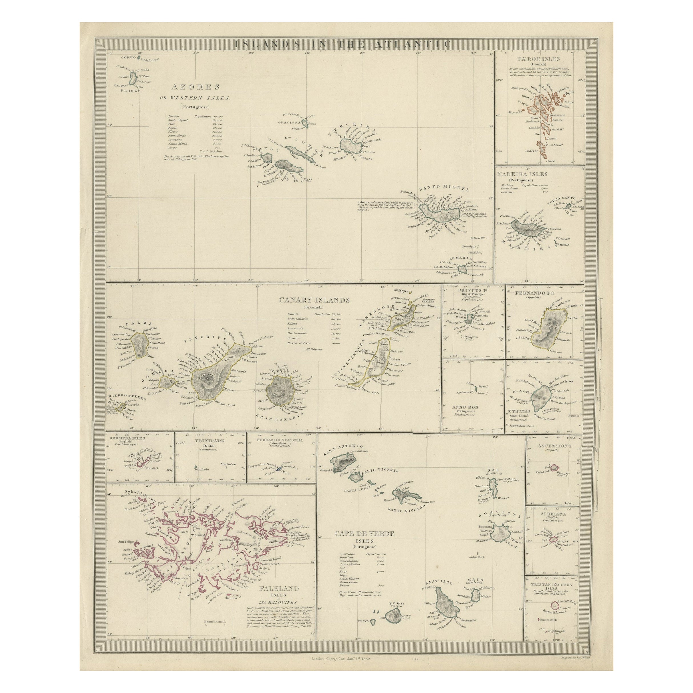
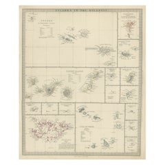
- Antique Map of the Islands in the Atlantic Ocean including Bermuda & Cape VerdeLocated in Langweer, NLAntique map titled 'Islands in the Atlantic'. Steel engraved map of the islands in the Atlantic Ocean. It shows 16 individual maps on one sheet. Covers the Azores or Western Isles, Faeroe Isles, Madeira Isles, Princes Island, Canary Islands, Fernando Po, Anno Bon, St. Thomas, Bermuda Isles, Trinidade Isles, Fernando Noronha, Cape Verde Isles, Ascension Island, St. Helena, Tristan d'Acunha Isles and the Falkland Isles. Engraved by J. & C. Walker. Published by George Cox...Category
Antique Mid-19th Century Maps
MaterialsPaper
- Antique Map of the Coast of Africa and the Cape Verde Islands, ca.1680Located in Langweer, NLAntique map Africa titled 'Isles du Cap Verd Coste et Pays des Negres'. Antique map of the coast of Africa and the Cape Verde islands. Artis...Category
Antique 1680s Maps
MaterialsPaper


You May Also Like
- Map of the Republic of GenoaLocated in New York, NYFramed antique hand-coloured map of the Republic of Genoa including the duchies of Mantua, Modena, and Parma. Europe, late 18th century. Dimension: 25...Category
Antique Late 18th Century European Maps
- Hand-Colored 18th Century Homann Map of Denmark and Islands in the Baltic SeaBy Johann Baptist HomannLocated in Alamo, CAAn 18th century copper plate hand-colored map entitled "Insulae Danicae in Mari Balthico Sitae utpote Zeelandia, Fionia, Langelandia, Lalandia, Falstria, Fembria Mona" created by Joh...Category
Antique Early 18th Century German Maps
MaterialsPaper
- Antique Map of Principality of MonacoBy Antonio Vallardi EditoreLocated in Alessandria, PiemonteST/619 - "Old Geographical Atlas of Italy - Topographic map of ex-Principality of Monaco" - ediz Vallardi - Milano - A somewhat special edition ---Category
Antique Late 19th Century Italian Other Prints
MaterialsPaper
- Original Antique Map of The World by Thomas Clerk, 1817Located in St Annes, LancashireGreat map of The Eastern and Western Hemispheres On 2 sheets Copper-plate engraving Drawn and engraved by Thomas Clerk, Edinburgh. Published by Mackenzie And Dent, 1817 ...Category
Antique 1810s English Maps
MaterialsPaper
- Antique 18th Century Map of the Province of Pensilvania 'Pennsylvania State'Located in Philadelphia, PAA fine antique of the colony of Pennsylvania. Noted at the top of the sheet as a 'Map of the province of Pensilvania'. This undated and anonymous map is thought to be from the Gentleman's Magazine, London, circa 1775, although the general appearance could date it to the 1760's. The southern boundary reflects the Mason-Dixon survey (1768), the western boundary is placed just west of Pittsburgh, and the northern boundary is not marked. The map has a number of reference points that likely refer to companion text and appear to be connected to boundaries. The western and southern boundaries are marked Q, R, S, for example. A diagonal line runs from the Susquehanna R to the Lake Erie P. A broken line marked by many letters A, B, N, O, etc., appears in the east. There are no latitude or longitude markings, blank verso. Framed in a shaped contemporary gilt wooden frame and matted under a cream colored matte. Bearing an old Graham Arader Gallery...Category
Antique 18th Century British American Colonial Maps
MaterialsPaper
- Map "Estuary- Mouth of the Thames"Located in Alessandria, PiemonteST/426 - Antique French Map of the estuary of the Thames, map dated 1769 - "Mape of the entrance of the Thames. Designed by filing of Navy cards fo...Category
Antique Mid-18th Century French Other Prints
MaterialsPaper


Recently Viewed
View AllMore Ways To Browse
Cape Beige
Antique Cape
Antique Capes
18th C American
Long Island Artists
Antique Boats Of America
18th C American Furniture
Cape Antique Furniture
Grande Date
18th Century Container
Fishing Collectibles
Used Furniture Santa Maria
Map Of American West
West African Antiques
Clark Antique
African American Collectibles
Antique Paper Roll
Map South Africa