
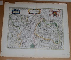
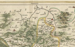
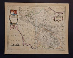
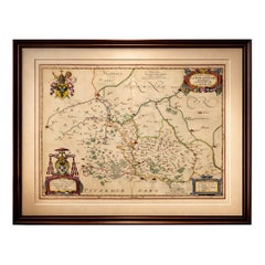
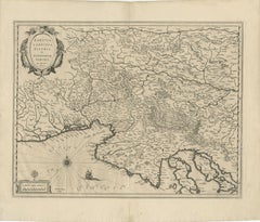
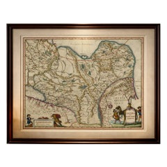
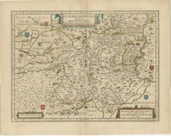
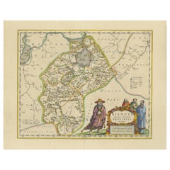
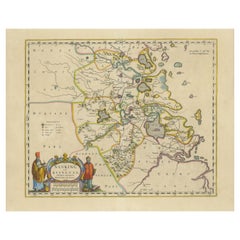
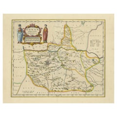
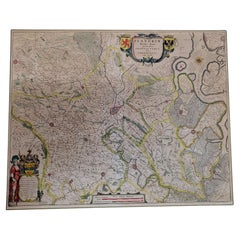
1571-1638 Willem Blaeu map entitled, "Ilcadorino, " Hand Colored Ric0009
Located in Norton, MA
Willem Blaeu map entitled, "Ilcadorino,". Hand colored. Description: large, unusual, and
Category
Antique 16th Century Dutch Maps
Materials
Paper
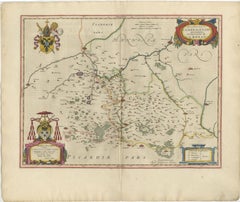
1571-1638 Willem Blaeu map entitled, "Ilcadorino, " Hand Colored Ric0009
Located in Norton, MA
Willem Blaeu map entitled, "Ilcadorino,". Hand colored. Description: large, unusual, and
Paper
$1,165Sale Price|20% Off
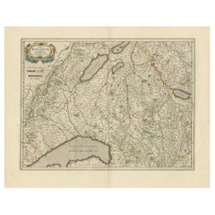
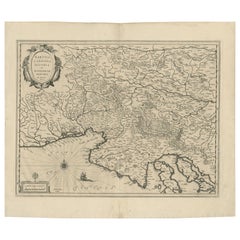
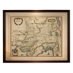
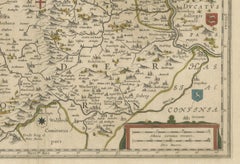
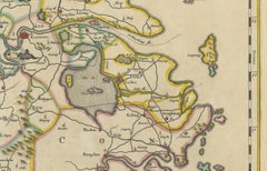
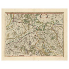
Circa 1659 Willem Blaeu Map: Southwestern Switzerland with Geneva & Lakes
Located in Langweer, NL
Circa 1659 Willem Blaeu Map: Southwestern Switzerland with Geneva & Lakes This detailed map from
Paper
$1,034Sale Price|20% Off
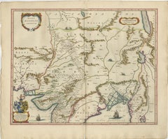
Circa 1659 Johannes Blaeu Map: Ducatus Silesiae Ligniciensis, Legnica Region
Located in Langweer, NL
Circa 1659 Johannes Blaeu Map: Ducatus Silesiae Ligniciensis, Legnica Region This hand-colored map
Paper
Antique Blaeu Map Vermandois & La Capelle France, Dual Sheet - 1642
Located in Langweer, NL
Antique Blaeu Map Vermandois & La Capelle France, Dual Sheet - 1642 A beautifully composed double
Paper
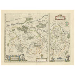
Decorative Blaeu Map of Picardy with Costume Figures, France 1642
Located in Langweer, NL
Antique Blaeu Map Picardy Region France, Decorative Costume Cartouche 1642 This elegant map of
Paper
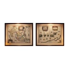
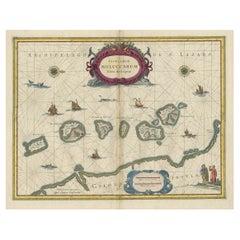
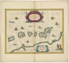
Antique Blaeu Maps, Indonesia & Moluccas – VOC Era, c.1642
Located in Langweer, NL
Antique Blaeu Maps, Indonesia & Moluccas – VOC Era, c.1642 A rare and highly decorative pair
Paper

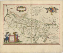
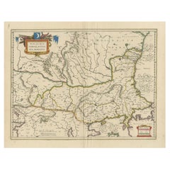
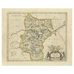
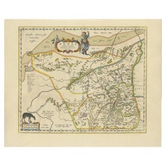
1640 Willem Blaeu Map Entitled "Contado di molise et principato vltra, " Ric.a003
By Willem Blaeu
Located in Norton, MA
1640 Willem Blaeu map entitled "Contado di molise et principato vltra," Colored Ric. a003
Paper
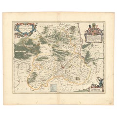
Ornate Blaeu Map of Cambrai & Artois, Rich Heraldic Cartouches, 1642
Located in Langweer, NL
Ornate Blaeu Map of Cambrai & Artois, Rich Heraldic Cartouches 1642 A richly decorative and
Paper

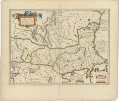
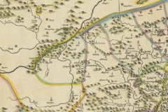
1635 Willem Blaeu Map of Northern France"Comitatvs Bellovacvm" Ric.a08
Located in Norton, MA
1635 Willem Blaeu map of northern France, entitled. "Comitatvs Bellovacvm Vernacule Beavvais
Paper
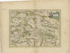
An Original Antique Mid-17th Century Blaeu Map of Styria in Southeastern Austria
Located in Langweer, NL
renowned Dutch cartographer Willem Janszoon Blaeu (often simply “Blaeu”). The first edition of this map was
Paper


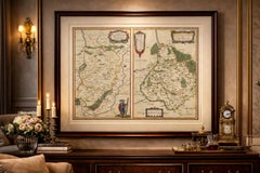
1643 Willem&Joan Blaeu Map NW Flanders "Flandriae Teutonicae Pars Prientalior
Located in Norton, MA
1643 Willem and Joan Blaeu map of northwest Flanders, entitled "Flandriae Teutonicae Pars
Paper
$1,028Sale Price|30% Off
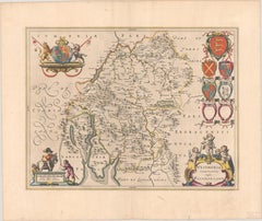
1645 Blaeu Map of Westmorland, Northern England – Hand Colored, Decorative
Located in Langweer, NL
cartography, and the decorative works of Willem Blaeu. Blaeu's maps are renowned for their accuracy, artistic
Paper
Original Antique Blaeu Map of Karst, Carniola, Istria, and Trieste, circa 1640
Located in Langweer, NL
Blaeu Map of Karst, Carniola, Istria, and Trieste, circa 1640 This is an original antique map
Paper
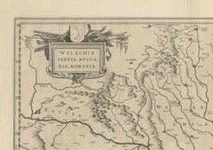
Blaeu Map of Ottoman Balkans – Walachia Bulgaria Romania, circa 1665
Located in Langweer, NL
Blaeu Map of Ottoman Balkans – Walachia Bulgaria Romania, circa 1665 This is an original hand
Paper

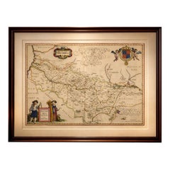
1654 Joan Blaeu Map the Sutherland, Scotland, Entitled "Southerlandia, "Ric0007
Located in Norton, MA
1654 Joan Blaeu map of the Sutherland, Scotland, entitled "Southerlandia," Hand Colored
Paper
Imperial Tartary Blaeu Map, Central Asia Caravan Scene c.1642
Located in Langweer, NL
Imperial Tartary Blaeu Map, Central Asia Caravan Scene c.1642 A visually captivating and highly
Paper
Imperial Mughal India Blaeu Map, Ganges Delta & Persia c.1642
Located in Langweer, NL
Imperial Mughal India Blaeu Map, Ganges Delta & Persia c.1642 A richly detailed and highly
Paper
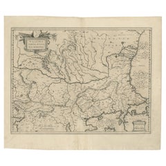
17th Century Blaeu Map – Ottoman Balkans: Walachia, Bulgaria, Romania, ca. 1650
Located in Langweer, NL
Blaeu Map of Walachia, Servia, Bulgaria, Romania, circa 1640 This is an original antique map
Paper
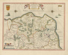
Golden Age Blaeu Map of Boulogne & Guînes, French Coast c.1642
Located in Langweer, NL
Golden Age Blaeu Map of Boulogne & Guînes, French Coast c.1642 A beautifully engraved and visually
Paper
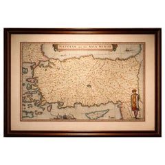
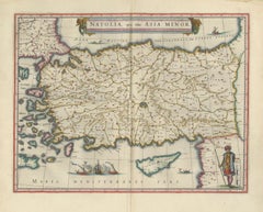
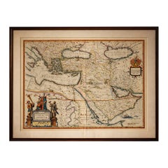
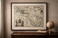
Blaeu Map of Anatolia, Asia Minor & Aegean, Ottoman Figure, c.1642
Located in Langweer, NL
Blaeu Map of Anatolia, Asia Minor & Aegean, Ottoman Figure, c.1642 A highly decorative and
Paper
Antique Blaeu Map of China, Japan & Korea, Exotic Cartouches & Ships, c.1642
Located in Langweer, NL
Antique Blaeu Map of China, Japan & Korea, Exotic Cartouches & Ships, c.1642 A highly
Paper

$3,290Sale Price|20% Off
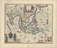
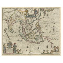
Original Blaeu Map of Southeast Asia from India to Tibet and Japan to New Guinea
Located in Langweer, NL
Antique map titled 'India quae Orientalis dicitur et Insulae Adiacentes'. Beautiful map of
Paper

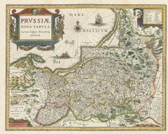
Antique Map of Prussia – Blaeu “Prussiae Nova Tabula”, c.1635
By Willem Blaeu
Located in Langweer, NL
Antique Map of Prussia – Blaeu “Prussiae Nova Tabula”, c.1635 Original antique engraved map titled
Paper
Willem Janszoon Blaeu Rare Original 17th Century Map of Ethiopia in a Pine Frame
By Willem Blaeu
Located in Meer, VAN
Willem Janszoon Blaeu Rare Original 17th Century Map of Ethiopia in a Pine Frame Rare early 17th
Pine, Paper
OriginaAntique 17th-Century Map of Guizhou Province, China – (Qveichev) by Blaeu
Located in Langweer, NL
Title: Antique 17th-Century Map of Guizhou Province, China – "Qveichev" by Blaeu, Richly
Paper
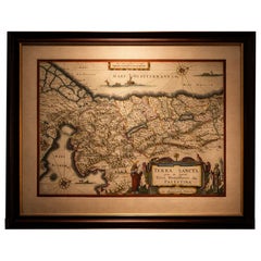
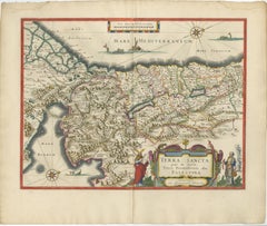
Blaeu Holy Land Map, Terra Sancta Palestina, Figural Cartouche, 1642
Located in Langweer, NL
Blaeu Holy Land Map, Terra Sancta Palestina, Figural Cartouche, 1629 A highly decorative and
Paper

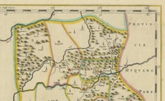
17th-Century Original Antique Map of Hunan and Hubei Provinces, China – by Blaeu
Located in Langweer, NL
Title: 17th-Century Antique Map of Hunan and Hubei Provinces, China – "Hvqvang" by Blaeu, Richly
Paper
Original Antique 17th-Century Map of Shanxi (Xansi) Province, China – by Blaeu
Located in Langweer, NL
Antique 17th-Century Map of Shanxi Province, China – "Xansi" by Blaeu, with Artistic Cartouches
Paper

$648Sale Price|20% Off
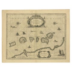
Old Map of the Moluccas, Known as the Famous Spice Islands, Indonesia, ca.1730
Located in Langweer, NL
Century, is the focus of this exquisite map. Similar to Blaeu's map, except that it extends further south
Paper
$488Sale Price|20% Off
Historic Map of the Bishopric of Paderborn by Blaeu, a Masterpiece of 1645
Located in Langweer, NL
. The title cartouche and decorative elements highlight the artistry typical of Blaeu maps, blending
Paper
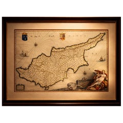
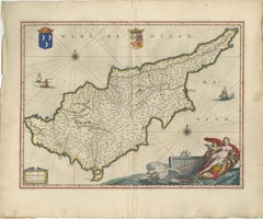
Blaeu Cyprus Map, Insula Cypri, Mythological Cartouche, c.1642
Located in Langweer, NL
Blaeu Cyprus Map, Insula Cypri, Mythological Cartouche, c.1642 A highly decorative and visually
Paper
17th-Century Antique Map of Jiangxi (Kiangsi) Province, China – by Blaeu
Located in Langweer, NL
Title: 17th-Century Antique Map of Jiangxi Province, China – "Kiangsi" by Blaeu, Detailed and
Paper
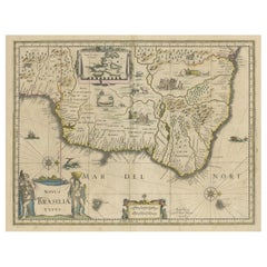
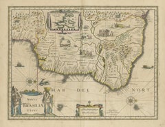
Antique Engraving of Blaeu's first Map of Brazil, Circa 1640
By Willem Blaeu
Located in Langweer, NL
Antique map titled 'Novus Brasiliae Typus'. Fine old color example of Blaeu's first map of Brazil
Paper
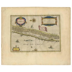
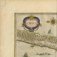
Antique Hand-Colored Map of Chili by Willem Blaeu, 1658
By Willem Blaeu
Located in Langweer, NL
Very decorative antique map of Chili published by W. Blaeu, 1658. This map depicts Chile from
Paper
Blaeu Ottoman Empire Map, Turcicum Imperium, Figural Cartouche, 1642
Located in Langweer, NL
Blaeu Ottoman Empire Map, Turcicum Imperium, Figural Cartouche, 1642 A striking and highly
Paper
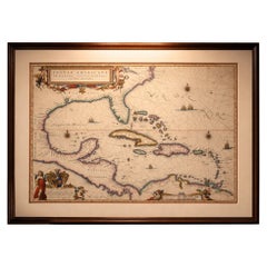
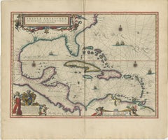
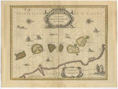
Important Blaeu Caribbean Map, West Indies, Decorative Atlas Chart, c.1642
Located in Langweer, NL
An important and Highly Decorative Blaeu Caribbean Map, West Indies, Antique Atlas Chart, c1642
Paper

Antique Map of the Spice Islands 'Moluccas', Indonesia by W. Blaeu, circa 1640
By Willem Blaeu
Located in Langweer, NL
Islands (Moluccas) published by W. Blaeu (circa 1640). This map features a large inset of the Island of
Paper

17th Century Framed Map of Ancient France Titled "Typus Galliae Veteris"
Located in Dallas, TX
renowned 16th-century cartographer Abraham Ortelius, this map was later published by Guillaume Blaeu, one
Glass, Giltwood, Paper
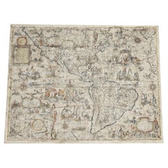
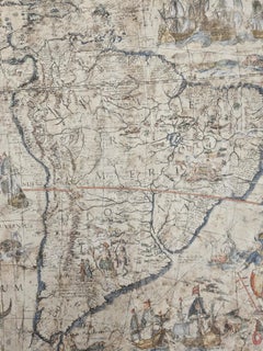
One of the most influential maps of America ever made, 17th Century Willem Blaeu
By Willem Blaeu
Located in ZWIJNDRECHT, NL
A rare and important 17th Century Italian Engraving of Willem Blaeu's Great Wall Map of America
Paper, Linen
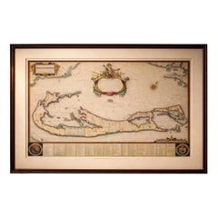
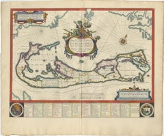
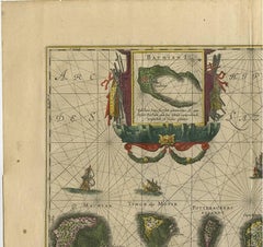
Blaeu Bermuda Map, Somers Isles, Atlantic Chart, Hand-Colored, c.1642
Located in Langweer, NL
Blaeu Bermuda Map, Somers Isles, Atlantic Chart, Hand-Colored, c.1642 Description: A highly
Paper
Original 17th-Century Antique Map of Nanjing Province, China – by Blaeu
Located in Langweer, NL
Title: 17th-Century Antique Map of Nanjing Province, China – "Nanking sive Kiangnan" by Blaeu, with
Paper
Original Antique 17th-Century Map of Shaangxi (Xensi) Province, China – by Blaeu
Located in Langweer, NL
Antique 17th-Century Map of Shaangxi Province, China – "Xensi" by Blaeu, Featuring Decorative
Paper

Original 17th-Century Antique Map of Henan (Honan) Province, China – by Blaeu
Located in Langweer, NL
17th-Century Antique Map of Henan Province, China – "Honan" by Blaeu, with Detailed Cartography and
Paper

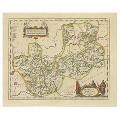
17th-Century Original Antique Map of Guangxi Province, China – Qvangsii by Blaeu
Located in Langweer, NL
Title: Antique 17th-Century Map of Guangxi Province, China – "Qvangsii" by Blaeu, Richly
Paper

$1,673Sale Price|20% Off
Original 17th-Century Antique Map of Fujian (Fokien) Province, China – by Blaeu
Located in Langweer, NL
17th-Century Antique Map of Fujian Province, China – "Fokien" by Blaeu, with Decorative Cartouches
Paper
$695Sale Price|20% Off
Beautiful Antique Map of the Moluccas or Spice Islands, Indonesia, ca.1650
Located in Langweer, NL
Century, is the focus of this exquisite map. Similar to Blaeu's map, except that it extends further south
Paper
$893Sale Price|30% Off
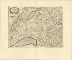
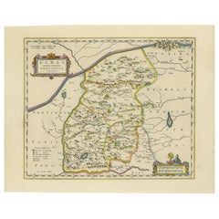
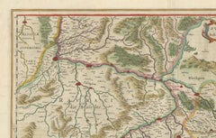
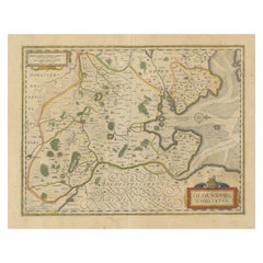
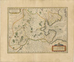
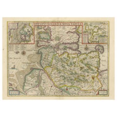
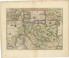
Map of Northwestern Switzerland (Basel and Zurich Region) by Willem & Jan Blaeu
Located in Langweer, NL
Map of Northwestern Switzerland by Willem & Jan Blaeu (Circa 1650) This is a detailed map of
Paper

$413Sale Price|20% Off
Loudun and Mirebeau: A Cartographic Masterpiece of 17th Century France by Blaeu
Located in Langweer, NL
uploaded is an original antique map titled "Loudonois - Mirebalais," created by Willem Janszoon Blaeu, a
Paper

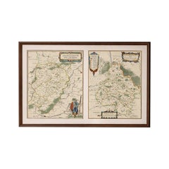
1640 Flandriae Partes Duae Quarum Altera Proprietaria, Ric0016
Located in Norton, MA
1640 Willem and Joan Blaeu map entitled "Flandriae Partes duae quarum altera Proprietaria, altera
Paper
$413Sale Price|20% Off
Antique Map of the Region of Oldenburg, Germany
By Willem Blaeu
Located in Langweer, NL
Antique map titled 'Oldenburg Comitatus'. Detailed old map of Oldenburg, Germany. The map also
Paper

$439Sale Price|20% Off
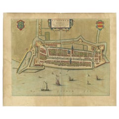
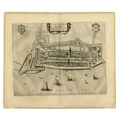
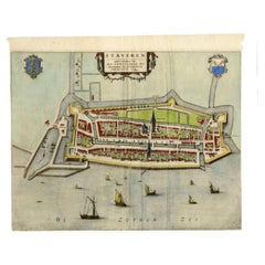
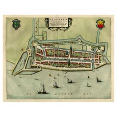
Antique Map of Stavoren by Blaeu, 1649
Located in Langweer, NL
Antique map titled 'Staveren'. Original antique map of the city of Stavoren, Friesland, The
Paper
$1,034Sale Price|20% Off
Original Antique Map of the Duchy of Holstein
By Willem Blaeu
Located in Langweer, NL
Antique map titled 'Ducatus Holsatiae Nova Tabula'. Original old map of the Duchy of Holstein, the
Paper

$327Sale Price|20% Off
Antique Map of Stavoren by Blaeu, 1649
Located in Langweer, NL
Netherlands. This map originates from 'Toonneel der Steden van de Vereenighde Nederlanden' by Joan Blaeu
Paper

$418Sale Price|20% Off
Antique Map of Stavoren by Blaeu, 1649
Located in Langweer, NL
Netherlands. This map originates from 'Toonneel der Steden van de Vereenighde Nederlanden' by Joan Blaeu
Paper

$347Sale Price|20% Off
Antique Map of Stavoren by Blaeu, 1649
Located in Langweer, NL
Netherlands. This map originates from 'Toonneel der Steden van de Vereenighde Nederlanden' by Joan Blaeu
Paper

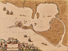
Cadiz Island: A Framed 17th Century Hand-colored Map from Blaeu's Atlas Major
By Joan (Johannes) Blaeu
Located in Alamo, CA
(Joan) Blaeu's Atlas Maior, published in Amsterdam in 1662. The map provides an excellent plan of Cadiz
Engraving
Antique Map of the Moluccas in Indonesia by Janssonius, C.1650
By Johannes Janssonius
Located in Langweer, NL
Century, is the focus of this exquisite map. Similar to Blaeu's map, except that it extends further south
Paper
Antique and vintage collectibles and curiosities can bring whimsy and wonder to any interior.
Decorating with old scientific instruments, historical memorabilia and vintage musical instruments, as well as other authentic collectibles and curiosities that can be found on 1stDibs, presents an opportunity to create a unique, natural history museum-like atmosphere in your home that can provoke conversation as often as it pays tribute to how far we’ve come in understanding our world.
And bringing collectibles and curiosities into your space is actually on trend — Wunderkammern, or curiosity cabinets, were all the rage in Europe during the 1500s and continued to have adherents there and in the U.S. in the following centuries. Today, however, they’re experiencing a real surge in popularity and influencing how many interior designers are furnishing and decorating homes — combining contemporary with antique, scientific with tribal, earthly with extraterrestrial, Les Lalanne tables with Flemish tapestries.
The original Wunderkammern were entire rooms filled with objects demonstrating their owners’ worldly knowledge: A proper one included artificiala or preciosa (objets d’art); naturalia (such as skeletons, shells, minerals); exotica (taxidermy or dried plants); and scientifica (scientific instruments), frequently alongside religious relics and ancient artifacts.
Pay tribute to a history of rich and diverse musical traditions that have taken shape all over the world by decorating your home with a collection of antique and vintage musical instruments — with a little help from strong hanging wire or some wall hooks, vintage brass instruments such as a gong, French horn or trumpet can help elevate a home office or complement the efforts you’ve made to ensure a welcoming vibe in your home’s entryway. Bells or antique wind instruments can add provocative metallic contrasts to dark woods as tabletop decorative objects.
Create an intriguing focal point with Georgian scientific instruments, such as stick barometers with mahogany cases or lacquered brass telescopes. These items stem from an era named for the monarchies of the four King Georges, who ruled England in succession starting in 1714 (plus King William’s reign, which lasted until 1837). Just as there was beautiful jewelry produced during the period that today is coveted by collectors, there is much to be found in the collectibles and curiosities realm too.
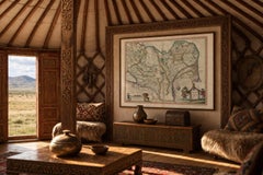
Wanderlust, nostalgia and a shared love of good design are contributing factors to certain trends in decorating — just as vintage trunks and luggage have reappeared as furniture or home accents in a bedroom or foyer, decorating with globes, maps or nautical objects is similarly rooted in the allure of travel and a penchant for the stylish finishing touch that collectibles bring to our homes.
Find a wide range of antique and vintage collectibles and curiosities on 1stDibs.
Produced in 1843, the well-preserved volume is evidence of the author's exacting specifications.
New or old, the coverlets add old-time charm to any space.
Get into the games! These items celebrate the events, athletes, host countries and sporting spirit.
French trendsetter and serial collector Daniel Rozensztroch tells us about his obsession with objects related to seafaring men.
It's hard to resist the allure of a beautiful pool. So, go ahead and daydream about whiling away your summer in paradise.
The sought-after designer worked with the team at Hoffman Creative to produce a monograph that beautifully showcases some of Studio Shamshiri's most inspiring projects.
Italian writer and collector Umberto Pasti opens the doors to his remarkable cave of wonders in North Africa.
Hollywood A-listers, ex-pat aristocrats and art collectors and style setters of all stripes appreciate the allure of the coastal California hamlet — much on our minds after recent winter floods.