Items Similar to Map of Americas
Want more images or videos?
Request additional images or videos from the seller
1 of 6
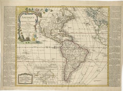
UnknownMap of Americas1783
1783
$470
£358.60
€408.24
CA$660.59
A$726.15
CHF 381.23
MX$8,634.44
NOK 4,895.80
SEK 4,459.54
DKK 3,050.18
About the Item
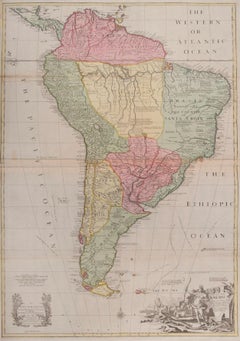
Over 200 year old engraved map of Americas by Robert de Vaugondy from 1783. Original hand color. Shows North, Central and South Americas. Note the possibility of a Northwest Passage and Great Ocean of the West with annotations in French.
Original antique map on paper displayed on a white mat with a gold border. Mat fits a standard-size frame. Archival plastic sleeve and Certificate of Authenticity included. Artwork, 16.5”L x 11.5”H; mat, 24”L x 18”H.
Enjoy a single shipping fee on combined purchases you make from MAPSandART.
- Creation Year:1783
- Dimensions:Height: 18 in (45.72 cm)Width: 24 in (60.96 cm)Depth: 0.1 in (2.54 mm)
- Medium:
- Period:1780-1789
- Condition:
- Gallery Location:Houston, TX
- Reference Number:Seller: K48321stDibs: LU10422361723
About the Seller
5.0
Platinum Seller
Premium sellers with a 4.7+ rating and 24-hour response times
Established in 2001
1stDibs seller since 2015
1,072 sales on 1stDibs
Typical response time: <1 hour
- ShippingRetrieving quote...Shipping from: Houston, TX
- Return Policy
More From This Seller
View AllAncient World Map
Located in Houston, TX
Over 150 year old engraved map of the world as it was known during the antiquities by cartographer Delamarche from 1838. Original hand color. Shows African, European and Asian cont...
Category
1830s More Prints
Materials
Ink, Watercolor, Handmade Paper
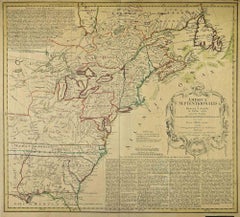
United States, 1844
Located in Houston, TX
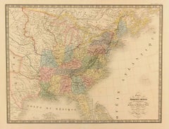
Over 150 year old map of early United States of America with Western Districts from 1844. Original hand color. Districts shown include Hurons, Sioux, Mandans, Osages, and Ozark. Note independent Republic of Texas...
Category
1840s More Prints
Materials
Ink, Watercolor, Handmade Paper
Map of Europe, 1844
Located in Houston, TX
Over 150 year old engraved map of Europe by Olney from 1844. Original hand color. Shows Northern Europe, Prussia and Germany.
Original antique map o...
Category
1840s More Prints
Materials
Ink, Watercolor, Handmade Paper

Antique Manuscript Map - Forest of Andely
Located in Houston, TX
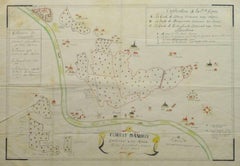
Charming hand drawn ink and watercolor map of the Forest of Andely, in the Normandy area, France, circa 1890.
Original artwork on paper displayed on...
Category
1890s More Art
Materials
Ink, Paper, Watercolor
Map of Denmark, 1724
Located in Houston, TX
Extraordinary copper engraved map of Denmark by cartographer Christoph Weigel from 1724. Shows counties, rivers and towns. Ornate title cartouche. Original hand-color. Over 250 years old.
Original antique map displayed...
Category
17th Century Other Art Style More Prints
Materials
Paper, Ink, Watercolor

Abstract
Located in Houston, TX
French lithograph abstract in green and yellow tones, circa 1960.
Original artwork on paper displayed on a white mat with a gold border. Mat fits a standard-size frame. Archival...
Category
1960s Abstract Prints
Materials
Watercolor

You May Also Like
The Americas - Vintage Map - 18th century
Located in Roma, IT
The Americas is a very beautiful vintage map realized in the 18th century by an Italian cartographer.
Very good conditions, on the right side the inscript...
Category
18th Century Figurative Prints
Materials
Paper, Etching

AMERICA
By John Speed
Located in Santa Monica, CA
IMPORTANT AMERICAN MAP - ONE OF THE FIRST TO SHOW CALIFORNIA as an ISLAND
JOHN SPEED (1552-1629)
AMERICA - With Those Known Parts In That Unknown Worlde (sic),
1626-(76) (Burden 217 iv/iv)
Engraving, uncolored. Engraved by Abraham Goos and published by Thomas Basset and Richard Chiswell - 4th state of 4 in 1676.15 1/8 x 20 1/2” From “A Prospect of the Most Famous Parts of the World”. Generally good condition. A repaired split in lower centerfold. This is the most common version of this important map...
Category
1620s Old Masters Landscape Prints
Materials
Engraving

$4,250 Sale Price
50% Off
Mythical Atlantis Restored - A 1694 Map of the Americas and Ancient Geography
Located in Langweer, NL
This rare and fascinating map, titled "Atlantis Insula a Nicolao Sanson Antiquitati Restituta" by Guillaume Sanson, presents an unusual interpretation of the Western Hemisphere, comb...
Category
Antique 1690s Maps
Materials
Paper
$1,849 Sale Price
20% Off
South America
By John Senex
Located in London, GB
South America
SENEX, John.
South America Corrected from the Observations Communicated to the Royal Society’s of London & Paris. By John Senex. To Edmund Halley. LLD. Savilian Professor of Geometry in Oxford and Fellow of the Royal Society. This Map corrected from His own Discoveries In gratefull Acknowledgement of his Ready assistance to Encourage this Designe is Humbly Dedicated.
John Senex, at the Globe against St Dunstans Church, Fleetstreet, London 1710 [-1728].
John Senex (1678-1740) was one of the foremost mapmakers in England in the early eighteenth century. He was also a surveyor, globemaker, and geographer. As a young man, he was apprenticed to Robert Clavell, a bookseller. He worked with several mapmakers over the course of his career, including Jeremiah Seller and Charles...
Category
1710s Naturalistic More Art
Materials
Watercolor, Engraving
$4,090
Detailed 1795 Map of the Americas with Exploration Tracks and Nice Cartouche
Located in Langweer, NL
This is a very handsome and rare 1795 map of the Americas titled "Amerique ou Nouveau Continent Dressee sur les Nouvelles Relations Decouvertes et Observations" by Jean Baptiste Noli...
Category
Antique 1790s Maps
Materials
Paper
$2,242 Sale Price
20% Off
Map of North America - Etching - 19th Century
Located in Roma, IT
Map of America is an etching realized during the 19th century.
Good condition.
Category
Early 19th Century Modern Figurative Prints
Materials
Etching
More Ways To Browse
Poster Vintage Italie
Radar Rat
Railways Trains Ussr
Red Grooms Elvis
Redoute Rose Prints
Redoute Roses
Regatta Poster
Retro Basketball Poster
Retro Pin Up Girl Poster
Rolls Royce Poster
Salvador Dali Fantastic Voyage
Salvador Dali Pencil Signed
Sevilla Poster
Sevilla Vintage Poster
Shepard Fairey Vote
Sunday B Morning
Tokion Poster
Tuscany Vintage Travel Poster