Map Art
to
19
179
146
73
40
30
Overall Width
to
Overall Height
to
124
131
133
80
2
1
4
19
35
29
8
17
3
3
30
162
38
34
18
4
2
2
1
293
140
3
468
149,263
77,578
49,458
41,518
36,157
34,467
29,653
26,051
25,743
23,262
20,250
16,521
15,273
14,490
13,591
12,953
11,024
10,298
10,158
150
136
128
70
32
32
30
28
11
10
34
222
286
130
Art Subject: Map
Reflection, Surrealist Etching with Aquatint by Jean Solombre
Located in Long Island City, NY
Jean Solombre, French (1948 - ) - Reflection, Year: 1980, Medium: Etching with Aquatint on Arches, signed, numbered and dated in pencil, Edition: 19/125, Image Size: 11 x 11 inch...
Category
1980s Surrealist Landscape Prints
Materials
Etching, Aquatint

French Modernist Oil Painting Green Tonal Landscape with Pink House
Located in Cirencester, Gloucestershire
The Pink House
French School, late 20th century
oil on un-stretched canvas, unframed
un-stretched canvas : 15.5 x 20 inches
Provenance: private collection, France
Condition: very goo...
Category
Mid-20th Century Modern Landscape Paintings
Materials
Oil

Original 1960 Map by Louis Dressen État du Katanga Congo
Located in PARIS, FR
This original 1960 poster by Louis Dressen, titled État du Katanga, is a rare and powerful visual document from one of the most turbulent moments in post-colonial African history. Pu...
Category
1960s Prints and Multiples
Materials
Paper, Lithograph

Manhattan Triptych, Set of Three NYC Conceptual Art Lithographs by Alan Sonfist
By Alan Sonfist
Located in Long Island City, NY
Part of a triptych, this rendering of Manhattan shows the uppermost area of the island of New York City. Along the coasts of the city are large illustrations of plants native to the ...
Category
1980s Conceptual Landscape Prints
Materials
Lithograph

1950 illustrated map Italy, Land of Saints and Sanctuaries
Located in PARIS, FR
In 1950, a highly detailed and artistically illustrated map titled Italie Terre de Saints et de Sanctuaires (Italy, Land of Saints and Sanctuaries) was published in Témoignage Chréti...
Category
1950s Prints and Multiples
Materials
Linen, Paper, Lithograph

AMERICA
By John Speed
Located in Santa Monica, CA
IMPORTANT AMERICAN MAP - ONE OF THE FIRST TO SHOW CALIFORNIA as an ISLAND
JOHN SPEED (1552-1629)
AMERICA - With Those Known Parts In That Unknown Worlde (sic),
1626-(76) (Burden 217 iv/iv)
Engraving, uncolored. Engraved by Abraham Goos and published by Thomas Basset and Richard Chiswell - 4th state of 4 in 1676.15 1/8 x 20 1/2” From “A Prospect of the Most Famous Parts of the World”. Generally good condition. A repaired split in lower centerfold. This is the most common version of this important map...
Category
1620s Old Masters Landscape Prints
Materials
Engraving


$4,250 Sale Price
50% Off
Signed Feminist LGBTQ+ Ink Graphite on Paper Drawing - Profile Notation 418.014
Located in New York, NY
Linda Stein, Profile Notation 418.014 - Signed Feminist LGBTQ+ Ink and Graphite on Paper Drawing
Profile Notation 418.014 is from Linda Stein's Profiles series--drawings, collages ...
Category
2010s Feminist Figurative Drawings and Watercolors
Materials
Paper, Ink, Graphite

Signed Feminist LGBTQ+ Colorful Ink on Paper Drawing - Profile Notation 418.015
Located in New York, NY
Linda Stein, Profile Notation 418.015 - Signed Feminist LGBTQ+ Colorful Ink, Color Pencil, Graphite on Paper Drawing
Profile Notation 418.015 is from Linda Stein's Profiles series-...
Category
2010s Feminist Figurative Drawings and Watercolors
Materials
Paper, Ink, Graphite, Color Pencil

16th c. woodcut map - Tabula Asiae Vlll
Located in Santa Monica, CA
SEBASTIAN MUNSTER (1488-1652)
ASIAE TABVLA Vlll 1540 (45)
Woodcut from Munster's edition of Geographia Universalis, Basel, Henri Petri. 1545 edit...
Category
16th Century Old Masters Landscape Prints
Materials
Woodcut

$950 Sale Price
29% Off
Original 'Bundesbahn durch das Gastliches Deutschland' vintage poster
Located in Spokane, WA
Linen-backed original German / Germany culinary map in excellent condition. MIT DER DEUTSCHEN BUNDESBAHN DURCH DAS GASTLICHE DEUTSCHLAND. Mit der Deutschen Bundesbahn durch das Gastliche Deutschland (With Deutsche Bundesbahn through Hospitable Germany).
A map of Germany showing all the food and wine features in various regions and cities. If you go to Germany and want to find the origins of foods, this will lead you to the correct city. From wine, bread, fish, cookies, spat, prezels, pork, bier, french...
Category
1950s American Modern Landscape Prints
Materials
Lithograph

$719 Sale Price
20% Off
Asia Declineatio: A 17th Century Hand-colored Map of Asia by Justus Danckerts
Located in Alamo, CA
This is a scarce 17th century beautifully hand-colored copperplate engraved map of Asia entitled “Exactissima Asiae Delineatio in Praecipuas Regiones Caerterasque Partes divisa et de...
Category
Late 17th Century Old Masters Landscape Prints
Materials
Engraving

Durham, English County Antique map, 1847
By Isaac Slater
Located in Melbourne, Victoria
Steel-engraved map with original outline colouring by Isaac Slater. A detailed engraved map of the English county with title, scale, and key. Decorated with an uncoloured engraved vi...
Category
19th Century Naturalistic Landscape Prints
Materials
Engraving

New Map of the Terraqueous Globe - WORLD MAP - CALIFORNIA AS AN ISLAND
By Edward Wells
Located in Santa Monica, CA
EDWARD WELLS (British 1667- 1727)
A NEW MAP of the TERRAQUEOUS GLOBE - according to the latest Discoveries and most general Divisions of it into CONTINENTS and OCEANS, 1700-01 (Shirley 609)
Engraved by Michael Burghers, Oxford. Hand-colored, Platemark 14 1/4 x 20 1/8 inches. Central cartouche flanked by figures representing the continents with dedication to William, Duke of Gloucester...
Category
Early 1700s Old Masters Landscape Prints
Materials
Engraving

Andre Derain, The Great Hunt, from Verve, Revue Artistique et Litteraire, 1940
By André Derain
Located in Southampton, NY
This exquisite lithograph by Andre Derain (1880–1954), titled La Grande Chasse (The Great Hunt), from Verve, Revue Artistique et Litteraire, Vol. II, No. 8, originates from the 1940 ...
Category
1940s Modern Landscape Prints
Materials
Lithograph

Circa 1950 poster Air Algérie regular line network
Located in PARIS, FR
The circa 1950 poster Air Algérie, réseau des lignes régulières by C. Rivière is a vibrant and captivating piece of mid-century commercial art that illustrates the network of regular...
Category
1950s Prints and Multiples
Materials
Linen, Paper, Lithograph

Direccion de Hidrografia... - Etching by Tomàs Gozàlez - 1802
Located in Roma, IT
Etching on paper realized, among the others, by Tomàs Gozàlez.
From Juan Corradi, Descubrimiento y conquista de la América o Compendio de la historia general del Nuevo Mundo, Madrid...
Category
Early 1800s Modern Figurative Prints
Materials
Etching

Accuratissima Galliae Tabula - Etching by Frederick de Wit - 1680ca
Located in Roma, IT
This double-page etching with contemporary coloring, entitled Accuratissima Galliae Tabula [...], was realized by the cartographer Frederick de Wit for the famous Atlas published in ...
Category
1680s Modern Figurative Prints
Materials
Etching

Original planisphere for Air France worldwide air network by Lucien Boucher
Located in PARIS, FR
Lucien Boucher 🇫🇷 (1889 - 1971) is a French painter, engraver, poster artist and designer.
He studied ceramics at the School of Sevres before being sent to the front in 1914.
Taken...
Category
1950s Prints and Multiples
Materials
Linen, Paper, Lithograph

Original "Flying Tigers" vintage airline poster. A legend in Air Cargo
Located in Spokane, WA
Original linen-backed ‘FLYING TIGERS - A legend in air cargo;, aviation vintage poster for sale. This poster is part of The Smithsonian National Air...
Category
Late 20th Century American Realist Landscape Prints
Materials
Offset

$519 Sale Price
20% Off
I Love Manhattan - Paint by Dario Cusani - 2000
Located in Roma, IT
TECHNIQUE PHOTO-PAINTING
The technique used was defined as PHOTO-PAINTING by the art critic Silvia Pegoraro of Ravenna Italy and was an Artist's invention in 1994. In fact, since 1964 Dario Cusani had been working with photography and painting which had never been united.
The Artist:
"In 1994 I returned to Naples, the city where I was born and had been missing for 10 years after moving to Rome in 1984. I returned to see the MIRACLE achieved by the G7 with the Presidents of the most powerful countries led by Bill Clinton, US President. It was a wonderful visit to my city reborn in its ancient splendor! I took over 5,000 photos of the squares and monuments of Naples with my Nikon. I returned to Rome and had all the photos printed and put them on various tables and assembled all the various pieces. I immediately realized that parts were missing which I completed with paint. A spontaneous gesture with which I had unconsciously achieved a great innovation: I had combined the REALITY of photography with the DREAM represented by painting. Silvia, my muse who knew me well, when I showed her the first work IMPERATING MALE (R:0176) that I had done she said to me: "Dario you have united the TWO WORLDS of your life: that of your childhood with the sensitivity of the dreamer with the concrete one that they gave you taught your parents with education, training (degree in Economic Sciences) and work started at 15 years old in your family's copper industry. These formative years had distanced myself from those of childhood when I studied the piano and dreamed of becoming an orchestra conductor. I also drew and painted with my imagination in search of the affections I was missing as my parents were busy in the factory rebuilding Italy destroyed by the recently ended war. I then refined PHOTO-PAINTING which developed into DIGITAL PROCESSING having replaced the BRUSH with the MOUSE to fill the gaps left by the photography and complete the REALITY which with painting became another FANTASTIC reality"
SOCIAL RESEARCH
This work is part of the SOCIAL "research" which addresses issues that concern people and the "polis" which in Latin means city but also "political model".
I LOVE MANHATTAN
In 1999 I was invited to have an exhibition at the Casa Italiana Zerilli Marimò in New York scheduled for September 2000. So I went to the BIG APPLE for the first time at the age of 50 and was amazed by the great vital energy I felt. Until then I had traveled abroad little because I was busy with studies, sports and already at 19 years old in my family's copper industry and after a few years also with my children who I had looked after a lot since they came into the world.
In NY I took many photos, but this work was born from another image: the map of the phantasmagoric subway!!! It was simple for me, since I was a child I looked at the clouds where I saw many shapes of people, animals etc. I saw at first sight the prow of a Jumbo, the famous giant of the skies, and sketched some sketches.
Upon returning to Rome I was in love with NY and it was easy to see in that map another image that is closely linked to love. The male penis...
Category
Early 2000s Contemporary Figurative Paintings
Materials
Acrylic

Union Pacific West vintage fun map railroad travel poster
Located in Spokane, WA
Original “The Union Pacific West fun map, archivally linen backed in very good condition. Ready to frame. This was initially folded, and the fold marks were ...
Category
1960s American Modern Landscape Prints
Materials
Offset

Tabula Indiae Orientalis - Etching by Frederick de Wit - 1680ca
Located in Roma, IT
This double-page etching with contemporary coloring, entitled Tabula Indiae orientalis, was realized by the cartographer Frederick de Wit for the famous Atlas published in Amsterdam ...
Category
1680s Modern Figurative Prints
Materials
Etching

Accuratissima Totius Asiae Tabula - Etching by Frederick de Wit - 1680 ca
Located in Roma, IT
This double-page etching with contemporary coloring, entitled Accuratissima totius Asiae Tabula, was realized by the cartographer Frederick de Wit for the famous Atlas published in A...
Category
1680s Modern Figurative Prints
Materials
Etching

PERU
By Johannes Jansson
Located in Santa Monica, CA
JOHANNES JANSSON (1588 - 1664)
PERU, engraving with early coloring. Platemark 15 1/8 x 19 3/8 inches, sheet 17 x 20 1/2
A nice example of one of the earliest maps of Peru. From the ...
Category
1630s Old Masters Landscape Prints
Materials
Engraving

Circa 1950 original poster by Luc-Marie Bayle for TAI - World map
By Lue Marie Bayle
Located in PARIS, FR
This circa 1950 original poster, created by Luc-Marie Bayle, celebrates the global reach of TAI (Transports Aériens Intercontinentaux), one of France’s pioneering airline companies. ...
Category
1950s Prints and Multiples
Materials
Paper, Lithograph

Dania Regnum - Etching by Frederick de Wit - 1680 ca
Located in Roma, IT
This double-page etching with contemporary coloring, entitled Dania Regnum [...], was realized by the cartographer Frederick de Wit for the famous Atlas published in Amsterdam in ca....
Category
1680s Modern Figurative Prints
Materials
Etching

Novissima et Accuratissima... - Etching by Frederick de Wit - 1680 ca
Located in Roma, IT
This double-page etching with contemporary coloring, entitled Novissima et Accuratissima Septentrionalis ac Meridionalis Americae, was realized by the cartographer Frederick de Wit f...
Category
1680s Modern Figurative Prints
Materials
Etching

Antique Map - Gallia - Etching by Johannes Janssonius - 1650s
Located in Roma, IT
Antique Map - Gallia is an antique map realized in 1650 by Johannes Janssonius (1588-1664).
The Map is Hand-colored etching, with coeval watercoloring.
Good conditions with slight ...
Category
1650s Modern Figurative Prints
Materials
Etching

Novissima et Accuratissima Totius.. - Etching by Frederick de Wit - 1680ca
Located in Roma, IT
This double-page etching with contemporary coloring, entitled Novissima et Accuratissima totius Italiae, Corsicae et Sardiniae, was realized by the cartographer Frederick de Wit for ...
Category
1680s Modern Figurative Prints
Materials
Etching

Carte Pour Servir a l'Histoire Philosophique.. - Etching by Rigobert Bonne- 1780
Located in Roma, IT
Etching on paper.
From Guillaume-Thomas Raynal, Histoire philosophique et politique des établissemens et du commerce des Européens dans les deux Indes, Geneva 1780.
This interestin...
Category
1780s Modern Figurative Prints
Materials
Etching

Accurata totius Archipelagi et Graeciae...- Etching by Frederick de Wit - 1680ca
Located in Roma, IT
This double-page etching with contemporary coloring, entitled Accurata totius Archipelagi et Graeciae Universae Tabula, was realized by the cartographer Frederick de Wit for the famo...
Category
1680s Modern Figurative Prints
Materials
Etching

Totius Africae Accuratissima Tabula - Etching by Frederick de Wit - 1680 ca
Located in Roma, IT
This double-page etching with contemporary coloring, entitled Totius Africae Accuratissima Tabula, was realized by the cartographer Frederick de Wit for the famous Atlas published in...
Category
1680s Modern Figurative Prints
Materials
Etching

Bermuda: An Early 17th Century Hand-colored Map by Henricus Hondius
By Henricus Hondius
Located in Alamo, CA
This attractive and interesting map of Bermuda by Henricus Hondius in 1633 is entitled "Mappa Aestivarum Insularum, Alias Barmudas". It is based on a ...
Category
Early 17th Century Old Masters Landscape Prints
Materials
Engraving

World Map - Etching by Hubert Nicholas-Jaillot - 1719
Located in Roma, IT
World map is an original modern artwork realized by Hubert Nicholas - Jaillot, printed by Louis Cordier in Paris 1719.
Etching on copper
The artwork depicts two hemispheres, conti...
Category
1710s Old Masters Figurative Prints
Materials
Etching

Louisiana: A Framed 19th Century Map by O.W. Gray
Located in Alamo, CA
This framed 19th century map of the Louisiana territory was published in "Gray's Atlas of the United States with General Maps of the World, accompanied by Descriptions Geographical, Historical, Scientific and Statistica" published in 1873 in Philadelphia by O.W. Gray and Son and Stedman, Brown and Lyon. It is a highly detailed map of Louisiana...
Category
1870s Landscape Prints
Materials
Engraving

Amstelredam - Etching by Johannes Janssonius - 1650s
Located in Roma, IT
Amstelredam is an ancient map realized in 1650 by Johannes Janssonius (1588-1664).
Good conditions.
From Atlantis majoris quinta pars, Orbem maritimum [Novus Atlas, volume V: carte...
Category
1650s Modern Figurative Prints
Materials
Etching

1956 original Air France poster “Réseau Aérien Mondial” (World Air Network)
Located in PARIS, FR
This 1956 original Air France poster, titled “Réseau Aérien Mondial” (World Air Network), is a stunning example of mid-century airline advertising. Designed at a time when air travel...
Category
1950s Prints and Multiples
Materials
Paper, Lithograph
")
Ancient Map - Macedonia - Etching by Johannes Janssonius - 1650s
Located in Roma, IT
Macedonia is an ancient map realized in 1650 by Johannes Janssonius (1588-1664).
The Map is Hand-colored etching, with coeval watercoloring.
Good condit...
Category
1650s Modern Figurative Prints
Materials
Etching

Australia, Tallis antique map, 1851
Located in Melbourne, Victoria
'Australia'
With decorative border surrounds and vignettes including a view of Sydney, Kangaroos, Natives of Australia Felix, Australian Parrots and Cockatoos and Natives of the Tri...
Category
19th Century Naturalistic Landscape Prints
Materials
Engraving

Antique Map - Mare Pacificum - Etching by Johannes Janssonius - 1650s
Located in Roma, IT
Mare Pacificum is an antique map realized in 1650 by Johannes Janssonius (1588-1664).
The Map is Hand-colored etching, with coeval watercolorang.
Good conditions with slight foxing...
Category
1650s Modern Figurative Prints
Materials
Etching

Epirus Albania - Etching by Johannes Janssonius - 1650s
Located in Roma, IT
Epirus Albania is an ancient map realized in 1650 by Johannes Janssonius (1588-1664).
Good conditions.
From Atlantis majoris quinta pars, Orbem maritimum [Novus Atlas, volume V: ca...
Category
1650s Modern Figurative Prints
Materials
Etching

1939 original map for Air France titled "Nova et Vetera" by Lucien Boucher
Located in PARIS, FR
In 1939, Lucien Boucher, a renowned French artist and illustrator, created a captivating map for Air France titled "Nova et Vetera", which translates to "New and Old" in Latin. This original lithographic poster is a remarkable fusion of vintage cartographic art and modern aviation, crafted as a promotional piece for the airline. It beautifully symbolizes the connection between the historic routes of exploration and the new ones made possible by air travel.
Boucher was celebrated for his unique ability to combine the romanticism of classic maps with the sleek, modern spirit of 20th-century flight. Among his series of illustrated maps for Air France, "Nova et Vetera" stands out with its nostalgic allure and references to history.
The map exudes the charm of the age of exploration, echoing the style of 16th- and 17th-century cartographers. Rendered in rich, earthy tones, it depicts brown continents framed by pale blue oceans, evoking the feel of antique navigational...
Category
1930s Prints and Multiples
Materials
Linen, Paper, Lithograph

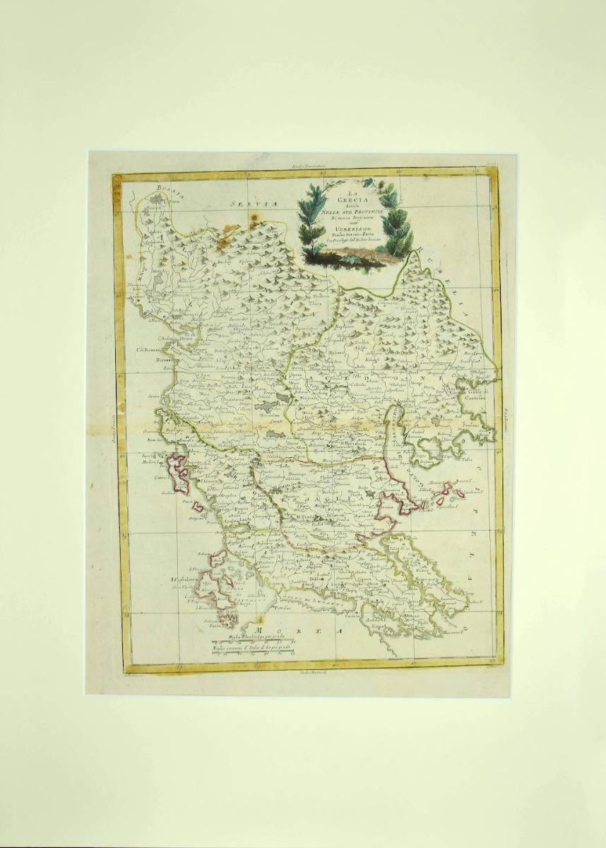
Map of Ancient Greece of Macedonia and... - Lithograph by Auguste Wahlen - 1844
Located in Roma, IT
Map of Ancient Greece of Macedonia and Thrace is a lithograph made by Auguste Wahlen in 1844.
Hand colored.
Good condition.
Bottom left is the original title "Carta della Grecia A...
Category
1840s Modern Figurative Prints
Materials
Lithograph

Orbis Terrarum - Etching by Johannes Janssonius - 1650s
Located in Roma, IT
Antique Map - Orbis Terrarum is an antique map realized in 1650 by Johannes Janssonius (1588-1664).
The Map is Hand-colored etching, with coeval watercoloring.
Good conditions with...
Category
1650s Modern Figurative Prints
Materials
Etching

S.Juan de Puerto Rico - Etching by Johannes Janssonius - 1650s
Located in Roma, IT
S.Juan de Puerto Rico is an ancient map realized in 1650 by Johannes Janssonius (1588-1664).
Good conditions.
From Atlantis majoris quinta pars, Orbem maritimum [Novus Atlas, volum...
Category
1650s Modern Figurative Prints
Materials
Etching

Archipelagus Septentrionalis - Etching by Johannes Janssonius - 1650s
Located in Roma, IT
Archipelagus Septentrionalis is an ancient map realized in 1650 by Johannes Janssonius (1588-1664).
Good conditions.
From Atlantis majoris quinta pars, Orbem maritimum [Novus Atlas...
Category
1650s Modern Figurative Prints
Materials
Etching

Ancient Map - Zeilan - Etching by Johannes Janssonius - 1650s
Located in Roma, IT
Ancient Map - Zeilan is an ancient map realized in 1650 by Johannes Janssonius (1588-1664).
The Map is Hand-colored etching, with coeval watercoloring.
...
Category
1650s Modern Figurative Prints
Materials
Etching

Barbarga - Etching by Johannes Janssonius - 1650s
Located in Roma, IT
Barbarga is an ancient map realized in 1650 by Johannes Janssonius (1588-1664).
Good conditions.
From Atlantis majoris quinta pars, Orbem maritimum [Novus Atlas, volume V: carte ma...
Category
1650s Modern Figurative Prints
Materials
Etching

Circa 1920 travel poster by Pollacchi for Compagnie Générale Transatlantique
Located in PARIS, FR
The circa 1920 travel poster by Pollacchi for Compagnie Générale Transatlantique, promoting Auto-circuits in North Africa, is a captivating example of early 20th-century travel adver...
Category
1920s Prints and Multiples
Materials
Linen, Paper, Lithograph

Ancient Map-Poli Arctici (Map of the Poles)-Etching by Johannes Janssonius-1650s
Located in Roma, IT
Poli Arctici is an ancient map realized in 1650 by Johannes Janssonius (1588-1664).
The Map is a Hand-colored etching, with coeval watercoloring.
Good conditions with slight foxing...
Category
1650s Modern Figurative Prints
Materials
Etching

Mare Atlanticum - Etching by Johannes Janssonius - 1650s
Located in Roma, IT
Mare Atlanticum is an ancient map realized in 1650 by Johannes Janssonius (1588-1664).
Good conditions.
From Atlantis majoris quinta pars, Orbem maritimum [Novus Atlas, volume V: c...
Category
1650s Modern Figurative Prints
Materials
Etching

Amstelredam - Etching by Johannes Janssonius - 1650s
Located in Roma, IT
Amstelredam is an ancient map realized in 1650 by Johannes Janssonius (1588-1664).
Good conditions.
from Atlantis majoris quinta pars, Orbem maritimum [Novus Atlas, volume V: carte...
Category
1650s Modern Figurative Prints
Materials
Etching

Nova Zemla - Etching by Johannes Janssonius - 1650s
Located in Roma, IT
Nova Zemla is an ancient map realized in 1650 by Johannes Janssonius (1588-1664).
Good conditions.
From Atlantis majoris quinta pars, Orbem maritimum [Novus Atlas, volume V: carte ...
Category
1650s Modern Figurative Prints
Materials
Etching

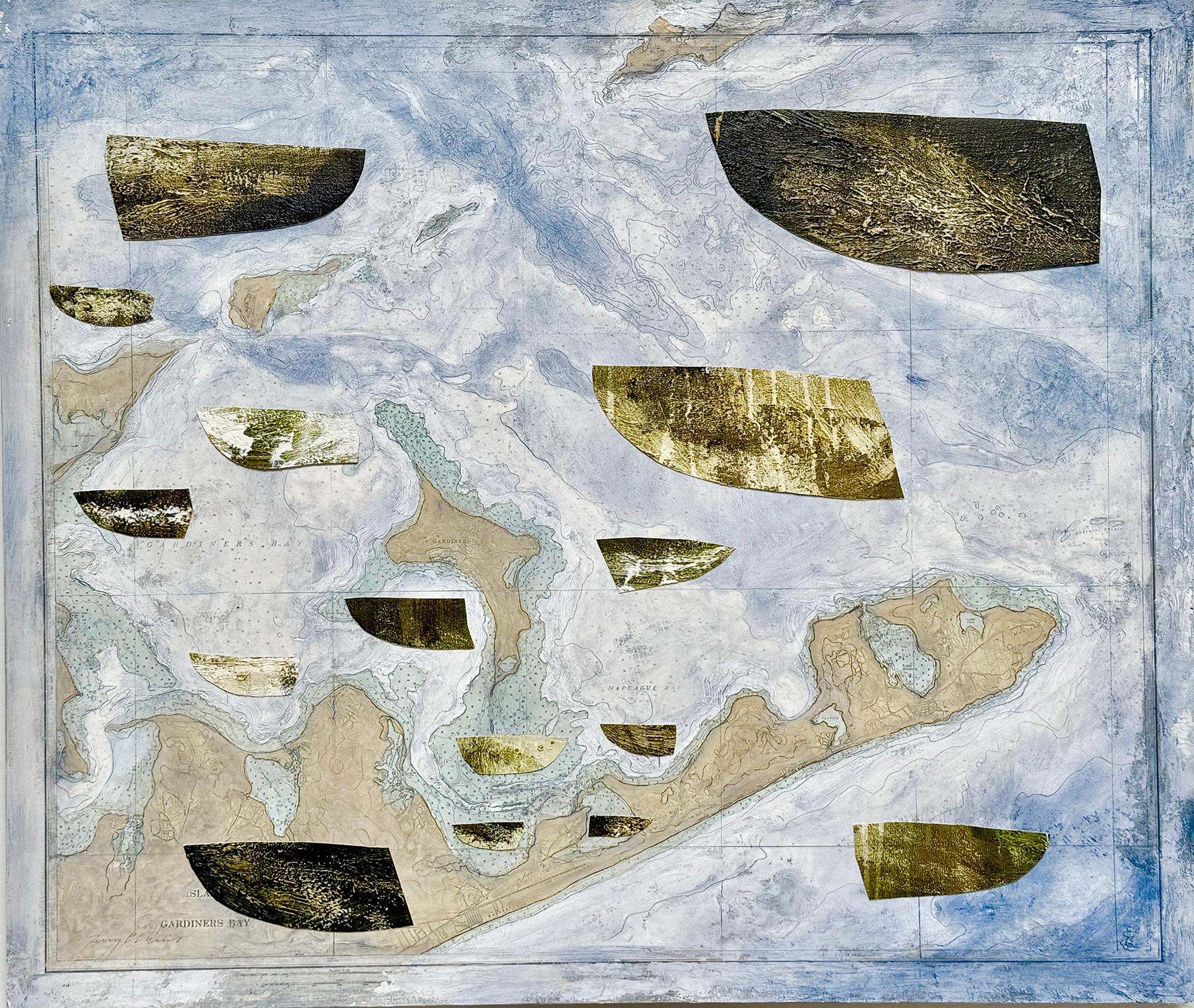
"East End Revisited" oil painting on map, boats, Gardiner's Bay, Long Island
By Terry Elkins
Located in Sag Harbor, NY
Collage with cut outs of oil on canvas, oil paint, and cut outs from maps of Gardiner's Island on wood board. Elkins utilizes old painted canvases, cut up in the shape of small boats...
Category
21st Century and Contemporary American Realist Landscape Paintings
Materials
Oil, Mixed Media, Board, Laid Paper

Cambridgeshire map 17th century engraving by John Speed
By John Speed
Located in London, GB
To see more, scroll down to "More from this Seller" and below it click on "See all from this Seller."
John Speed (1551 or 1552 - 1629)
Map of Cambridgeshire
Engraving with later hand colouring
39 x 53 cm
A beautifully coloured map of Cambridgeshire, with an antique description...
Category
1610s Landscape Prints
Materials
Engraving

Original poster to promote the 4th Tour de France of the Grand-mères automobiles
Located in PARIS, FR
The purpose of the poster was to promote the 4th Tour de France of the "Grand-mères automobiles" which was held from September 9 to 22, 1985.
The "Grand-Mères-Automobiles" were born ...
Category
1950s Prints and Multiples
Materials
Paper, Lithograph

18th-century celestial - Eridanus Orion Lepus
Located in London, GB
18th-century celestial
FLAMSTEED, John.
Eridanus Orion Lepus
London, C. Nourse, 1753.
A fine star chart from the Atlas Coelestis, the largest and most accurate star atlas publish...
Category
1750s Naturalistic Figurative Prints
Materials
Watercolor, Engraving

John Speede, Map of the County of Surrey, described and divided into hundreds
By John Speed
Located in London, GB
To see our other views and maps of England - including London, Oxford and Cambridge, scroll down to "More from this Seller" and below it click on "See all from this Seller" - or send us a message if you cannot find the view you want.
John Speed/Speede (1551/2-1629)
The County of Surrey Described and Divided into Hundreds
Engraving with later hand colouring and text to the reverse.
Dated to c.1650
36 x 49 cm
Probably the most famous early English mapmaker, John Speed's early life is somewhat of an enigma. He is believed to have trained as a rolling-press printer, but he was at heart an historian granted a sinecure in the Customs House by Queen Elizabeth to indulge his passion, later becoming a Fellow of the Society of Antiquaries. His first maps were historical, of the Holy Land 'Canaan as it was Possessed both in Abraham and Israels Dayes' and of England and Ireland recording 'all their Civill Warres since the Conquest'.
In 1611 he published his 'Hostory of Great Britaine' which he regarded as his magnum opus, but it was the companion atlas 'Theatre of the Empire of Great Britaine' that - as the first printed atlas of Great Britain - sealed his reputation. William Rogers engraved the first map, 'the County Palatine of Chester' in about 1600, but following his untimely death the task of engraving was passed to Jodocus Hondius of Amsterdam.
By 1612 the atlas was complete, the maps famed for their decorative elements. Many have town plans - Britain's first series of such plans - and descriptive text was printed to the reverse until the 1676 edition. Later printings (up until 1770) were issued without this text. By 1627 it has become a part of a world atlas 'Prospect of the Most Famous Parts of the World'. During the 17th century the plates passed through the hands of a series of publishers, the 1676 edition of Thomas Bassett and Richard Chiswell being regarded as its high point with the inclusion for the first time of a series of important maps. For the first half of the eighteenth century they were firmly established in the hands of the Overton family.
This particular edition originally featured in The Theatre Of The Empire Of Great Britaine. It features attractive inset views of the long-since destroyed Richmond...
Category
17th Century Realist Landscape Prints
Materials
Engraving

18th-century celestial - Andromeda Perseus Triangulum
Located in London, GB
18th-century celestial
FLAMSTEED, John.
Andromeda Perseus Triangulum
London, C. Nourse, 1753.
A fine star chart from the Atlas Coelestis, the largest and most accurate star atlas ...
Category
1750s Naturalistic Figurative Prints
Materials
Watercolor, Engraving

LONG STANDING #2
Located in Aventura, FL
Lithograph on paper. Sheet size 19 x 12 inches. Hand signed, dated and numbered by the artist. Edition of 300.
Certificate of Authenticity Included. Artwork in Excellent Conditi...
Category
Late 20th Century Contemporary Figurative Prints
Materials
Paper, Lithograph

$80 Sale Price
36% Off
Still Thinking About These?
All Recently ViewedMore Ways To Browse
Royal Air Maroc
Saint Tropez Sign
Salcombe Paintings
Salinas Bluebonnets
San Francisco City Painting
Sandhill Crane Painting
Sarah Russell
Schenck Artist
Sea Painting 17th Century
Seascape Of New England
Sergio Castillo
Seville Poster
Shinkichi Tajiri
Ship Painting 18th Century
Shishkin Ivan
Sidney Pike
Sleeping Dog Painting
Small Paintings Gold Frames