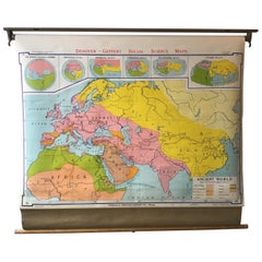
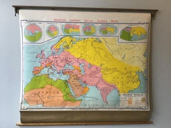
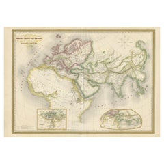
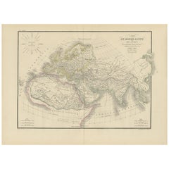
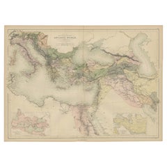
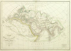
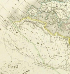
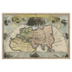
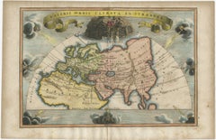
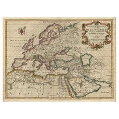
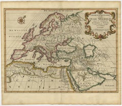
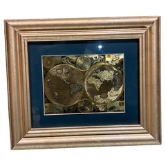
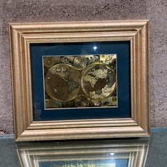
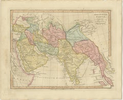
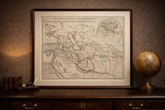
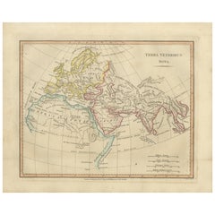
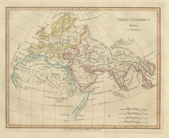
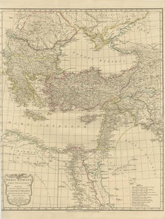
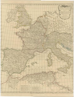
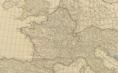
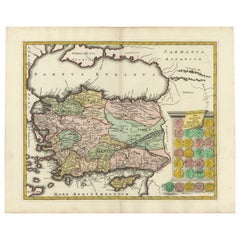
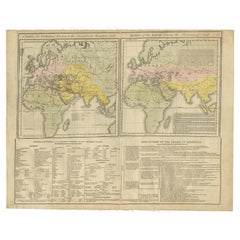
Ancient World Map

Ancient World Map
Ancient World Map

Ancient World Map

Located in Houston, TX

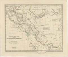
Over 150 year old engraved map of the world as it was known during the antiquities by cartographer Delamarche from 1838. Original hand color. Shows African, European and Asian cont...

Category

1830s More Prints

Materials

Ink, Watercolor, Handmade Paper
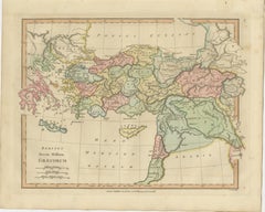
Antique Ancient World Map – Orbis Veteribus Notus, Engraving c.1818

Antique Ancient World Map – Orbis Veteribus Notus, Engraving c.1818

Located in Langweer, NL

Antique Ancient World Map – Orbis Veteribus Notus, Engraving c.1818 Striking antique map depicting the world as known to the ancient classical civilizations, extending from Western ...

Category

Antique Early 19th Century British Maps

Materials

Paper

Veteris Orbis Climata – Ancient World Map after Strabo by Cellarius, 1731

Veteris Orbis Climata – Ancient World Map after Strabo by Cellarius, 1731

Located in Langweer, NL

Veteris Orbis Climata – Ancient World Map after Strabo by Cellarius, 1731 This fascinating hand-colored antique map, titled Veteris Orbis Climata ex Strabone, is a classical represe...

Category

Antique 1730s Maps

Materials

Paper

Ancient World Map: Europe, Africa & Asia - 1802 Tardieu Atlas

Ancient World Map: Europe, Africa & Asia - 1802 Tardieu Atlas

Located in Langweer, NL

Purpose and Use: This map serves as a visual representation of ancient geographical knowledge, likely used for educational purposes in understanding the ancient world's extent and t...

Category

Antique Early 1800s Maps

Materials

Paper

Ancient World Map, Roman Macedonian Persian Empires, Ferrario 1815

Ancient World Map, Roman Macedonian Persian Empires, Ferrario 1815

Located in Langweer, NL

Antique Map of Asia 1815 – Carta Generale dell’Asia, Ferrario, Italy This refined early 19th-century map presents a comprehensive view of the Asian continent, titled Carta Generale ...

Category

Antique Early 19th Century Italian Prints

Materials

Paper

World According to Herodotus – Antique Classical World Map, Wilkinson 1819

World According to Herodotus – Antique Classical World Map, Wilkinson 1819

Located in Langweer, NL

Keyword block: Herodotus world map, world according to Herodotus, ancient world map, classical geography map, James Rennell map, Robert Wilkinson map, London 1819 map, Atlas Classica...

Category

Antique Early 19th Century British Maps

Materials

Paper

Late 20th Century Gold Foil World Map Double Hemisphere

Late 20th Century Gold Foil World Map Double Hemisphere

Located in Chula Vista, CA

Late 20th Century Gold Foil Ancient World Map Double Hemisphere Gold Foil Old World Framed Map information on reverse of the print.

Category

Late 20th Century English Mid-Century Modern Prints

Materials

Gold

Ancient Europe Map 1652, Europa Antiqua – Nicolas Blancardus, Roman World

Ancient Europe Map 1652, Europa Antiqua – Nicolas Blancardus, Roman World

Located in Langweer, NL

Ancient Europe Map 1652, Europa Antiqua – Nicolas Blancardus, Roman World Description: This uncommon mid-17th-century map of ancient Europe presents the classical world as understoo...

Category

Antique Mid-17th Century Dutch Maps

Materials

Paper

Antique Map of the Ancient Middle East & India – Wilkinson Orientis Tabula, 1807

Antique Map of the Ancient Middle East & India – Wilkinson Orientis Tabula, 1807

Located in Langweer, NL

Antique Map of the Ancient Middle East & India – Wilkinson Orientis Tabula 1807 Description: This finely engraved and beautifully hand-colored antique map titled “Orientis Tabula” p...

Category

Antique Early 19th Century British Maps

Materials

Paper

Roman Italy and Provinces: A Cartographic Snapshot, 1880

Roman Italy and Provinces: A Cartographic Snapshot, 1880

Located in Langweer, NL

**Educational Purpose**: The map was designed to aid in the study of Roman history, providing a visual tool for understanding the ancient world.

Category

Antique 1880s Maps

Materials

Paper

Ancient Persian Empire Map of Persia, Babylon & Arabia, Published 1831

Ancient Persian Empire Map of Persia, Babylon & Arabia, Published 1831

Located in Langweer, NL

Delicate outline hand-coloring distinguishes provinces and territories while preserving the restrained academic appearance characteristic of these sought-after atlas maps. Ancient ci...

Category

Antique Early 19th Century British Maps

Materials

Paper

Antique Map Near East & Persia, Ancient Monarchies – Delamarche c.1795

Antique Map Near East & Persia, Ancient Monarchies – Delamarche c.1795

Located in Langweer, NL

It represents the eastern portion of a larger geographical concept illustrating the territories of the ancient world. The map covers a vast and historically significant region stret...

Category

Antique Late 18th Century French Maps

Materials

Paper

Terra Veteribus Nota — Classical World Map of Antiquity, Wilkinson 1814

Terra Veteribus Nota — Classical World Map of Antiquity, Wilkinson 1814

Located in Langweer, NL

Technique: Copperplate engraving with original hand color Maker: Wilkinson, London, 1827 Keyword block (important places and themes visible on the map): Terra Veteribus Nota, classi...

Category

Antique Early 19th Century British Maps

Materials

Paper

Classical World Map of Greece, Asia Minor & Levant, Wilkinson Atlas 1817

Classical World Map of Greece, Asia Minor & Levant, Wilkinson Atlas 1817

Located in Langweer, NL

Classical World Map Greece Asia Minor & Levant, Wilkinson Atlas 1817 This finely engraved and delicately hand-colored map of the ancient Greek world and surrounding regions was publ...

Category

Antique Early 19th Century British Maps

Materials

Paper

Eastern Roman World Map, Black Sea & Levant, Antique Engraving c.1818

Eastern Roman World Map, Black Sea & Levant, Antique Engraving c.1818

Located in Langweer, NL

keywords: antique map, roman empire map, eastern roman empire, roman world map, ancient geography, classical cartography, d’anville map, laurie and whittle, 19th century map, antique...

Category

Antique Early 19th Century British Maps

Materials

Paper

Old Map of Ancient Times covering Egypt Towards Arabia and India to Java, c.1660

Old Map of Ancient Times covering Egypt Towards Arabia and India to Java, c.1660

Located in Langweer, NL

It included a description of ""most of the cities of the world"" (Townatlas), of the waterworld (Atlas Maritimus in 33 maps), and of the Ancient World (60 maps).

Category

Antique 1660s Maps

Materials

Paper

Antique Roman Empire Map – Western Mediterranean & Europe, Engraving c.1818

Antique Roman Empire Map – Western Mediterranean & Europe, Engraving c.1818

Located in Langweer, NL

When paired with the matching Eastern Roman Empire map, the two sheets create a balanced, museum-style presentation of the ancient world.

Category

Antique Early 19th Century British Maps

Materials

Paper

Alexander the Great’s Empire Map — Classical Campaign Routes, c.1800

Alexander the Great’s Empire Map — Classical Campaign Routes, c.1800

Located in Langweer, NL

Keywords: Alexander the Great, empire map, ancient world, classical antiquity, Macedonia, Persia, Egypt, India, campaign routes, military history, antique map, Vuillemin, French cart...

Category

Antique Early 19th Century French Maps

Materials

Paper

Decorative Antique Map of Cyprus and Asia Minor by Christoph Weigel, Circa 1720

Decorative Antique Map of Cyprus and Asia Minor by Christoph Weigel, Circa 1720

Located in Langweer, NL

The map offers a detailed representation of Cyprus and Asia Minor, showcasing the geographical knowledge and features known to the ancient world.

Category

Antique 1720s Maps

Materials

Paper

1720 Weigel Engraving of Jerusalem: A Biblical View from Josephus' Perspective

1720 Weigel Engraving of Jerusalem: A Biblical View from Josephus' Perspective

Located in Langweer, NL

Coccejo, engraved by Christoph Weigel, offers a fascinating glimpse into the sacred city's historical and biblical significance. The map is based on the accounts of Josephus, the ren...

Category

Antique 1720s Maps

Materials

Paper

Original Antique Engraving of a Sea Chart of the Western Mediterranean, ca.1650

Original Antique Engraving of a Sea Chart of the Western Mediterranean, ca.1650

Located in Langweer, NL

It included a description of ""most of the cities of the world"" (Townatlas), of the waterworld (Atlas Maritimus in 33 maps), and of the Ancient World (60 maps).

Category

Antique 1650s Maps

Materials

Paper

Maps of the Ancient World and the Posterity of Noah, 1820

Maps of the Ancient World and the Posterity of Noah, 1820

Located in Langweer, NL

Two maps on one sheet. Hhand colored engraved lithograph, depicting the world as known to the Ancients on Mercator's projection and the Posterity of Noah. The first showns the Empire...

Category

Antique 19th Century Prints

Materials

Paper

Recent Sales

Very decorative world map of the ancient world by Mercator - Engraving - 17th c.

Very decorative world map of the ancient world by Mercator - Engraving - 17th c.

By Gerard Mercator

Located in Zeeland, Noord-Brabant

.' - Very decorative worldmap of the ancient world. Surrounded by allegorical figures representing the four elements: Fire (Zeus), Air (Hera), Water (Neptune) and Earth (Gaia).

Category

1690s Old Masters More Prints

Materials

Engraving

Ducatus Gelriae pars prima quae est Neomagensis.

Ducatus Gelriae pars prima quae est Neomagensis.

By Johannes Janssonius

Located in Zeeland, Noord-Brabant

It included a description of "most of the cities of the world" (Townatlas), of the waterworld (Atlas Maritimus in 33 maps), and of the Ancient World (60 maps).

Category

Mid-17th Century More Prints

Materials

Engraving, Etching

Trasisalania vulgo Overyssel.

Trasisalania vulgo Overyssel., 1646

Unavailable

H 19.53 in W 23 in

Trasisalania vulgo Overyssel.

Located in Zeeland, Noord-Brabant

It included a description of "most of the cities of the world" (Townatlas), of the waterworld (Atlas Maritimus in 33 maps), and of the Ancient World (60 maps).

Category

Mid-17th Century More Prints

Materials

Engraving, Etching

Ducatus Gelriae pars quarta quae est Arnhemiensis, sive Velavia.

Ducatus Gelriae pars quarta quae est Arnhemiensis, sive Velavia.

By Johannes Janssonius

Located in Zeeland, Noord-Brabant

It included a description of "most of the cities of the world" (Townatlas), of the waterworld (Atlas Maritimus in 33 maps), and of the Ancient World (60 maps).

Category

Mid-17th Century More Prints

Materials

Engraving, Etching

Tabula Castelli ad Sandflitam, qua simul inundati agri, alluviones, [...].

Tabula Castelli ad Sandflitam, qua simul inundati agri, alluviones, [...].

By Johannes Janssonius

Located in Zeeland, Noord-Brabant

It included a description of "most of the cities of the world" (Townatlas), of the waterworld (Atlas Maritimus in 33 maps), and of the Ancient World (60 maps).

Category

Mid-17th Century More Prints

Materials

Engraving, Etching

1968 Ancient World School Map

1968 Ancient World School Map

Sold

H 48 in W 3 in D 3.5 in

1968 Ancient World School Map

Located in Tarrytown, NY

Pull down school map of the ancient world made, in Chicago in the 1960s.

Category

Vintage 1960s Maps

Materials

Paper

1960s Large Italian World Map Globe Bar Cart or Drinks Trolley with Zodiac Signs

1960s Large Italian World Map Globe Bar Cart or Drinks Trolley with Zodiac Signs

Located in London, England

Highly decorative Italian mid century world map globe bar cart or drinks trolley decorated with an ancient world map with different colours for each country.

Category

Vintage 1960s Italian Mid-Century Modern Carts and Bar Carts

Materials

Walnut

Rare 17th Century American Map of Virginia and Florida by Jan Janssonius

Rare 17th Century American Map of Virginia and Florida by Jan Janssonius

By Jan Johansson

Located in Wiscasset, ME

It included a description of "most of the cities of the world" (Townatlas), of the waterworld (Atlas Maritimus in 33 maps), and of the Ancient World (60 maps).

Category

Antique 18th Century and Earlier Dutch Rococo Maps

Original Antique Bird's Eye View Plan of Hoorn, The Netherlands by Blaeu, c.1700

Original Antique Bird's Eye View Plan of Hoorn, The Netherlands by Blaeu, c.1700

Located in Langweer, NL

It included a description of ""most of the cities of the world"" (Townatlas), of the waterworld (Atlas Maritimus in 33 maps), and of the Ancient World (60 maps).

Category

Antique Early 1700s Maps

Materials

Paper

Very Large Antique Brass and Mahogany Atlas Coffee Table

Very Large Antique Brass and Mahogany Atlas Coffee Table

Located in London, GB

There's a brass top edge which holds in a glass top over an ancient map of the world. The map is typical of the way the ancient people depicted the world and how it would show on the...

Category

Vintage 1950s English Coffee and Cocktail Tables

Materials

Brass

Vintage globe bar, 1950s

Vintage globe bar, 1950s

Sold

H 41.34 in W 37.41 in D 25.6 in

Vintage globe bar, 1950s

Located in Leuven, Vlaams Gewest

Vintage globe bar on wheels with an old world map and ancient drawings troughout. Brass casters and decor, bobbin legs,..the cart is full of nice design elements showing its quality.

Category

Vintage 1950s Belgian Neoclassical Carts and Bar Carts

Materials

Brass

Antique Map of the Ancient World 'c.1860'

Antique Map of the Ancient World 'c.1860'

Sold

H 24.02 in W 33.08 in D 0.02 in

Antique Map of the Ancient World 'c.1860'

Located in Langweer, NL

Antique map titled 'Monde connu des Anciens'. Large, original antique map of the Ancient World, including Asia, Europe and Africa.

Category

Antique Mid-19th Century Maps

Materials

Paper

Antique Map of the Ancient World by Lapie, 1842

Antique Map of the Ancient World by Lapie, 1842

Sold

H 19.89 in W 26.78 in D 0.02 in

Antique Map of the Ancient World by Lapie, 1842

Located in Langweer, NL

Antique map titled 'Carte du Monde Connu des Anciens'. Map of the Ancient World.

Category

Antique Mid-19th Century Maps

Materials

Paper

Antique Map of the Ancient World by Cellarius, 1703

Antique Map of the Ancient World by Cellarius, 1703

Located in Langweer, NL

Interesting map of the ancient world divided into seven climatic zones.

Category

Antique Early 18th Century Maps

Materials

Paper

Antique Map of the Ancient World by A & C. Black, 1870

Antique Map of the Ancient World by A & C. Black, 1870

Located in Langweer, NL

Antique map titled 'Map of the Principal Countries of the Ancient World'.

Category

Antique Late 19th Century Maps

Materials

Paper

Get Updated with New Arrivals
Save "Ancient World Map", and we’ll notify you when there are new listings in this category.

Ancient World Map For Sale on 1stDibs

With a vast inventory of beautiful furniture at 1stDibs, we’ve got just the ancient world map you’re looking for. Each ancient world map for sale was constructed with extraordinary care, often using paper. Your living room may not be complete without an ancient world map — find older editions for sale from the 18th Century and newer versions made as recently as the 20th Century. You’ll likely find more than one ancient world map that is appealing in its simplicity, but Gerard Mercator produced versions that are worth a look.

How Much is a Ancient World Map?

Prices for an ancient world map start at $269 and top out at $3,218 with the average selling for $483.

Read More