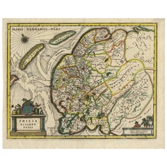
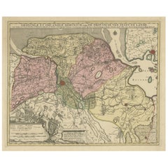
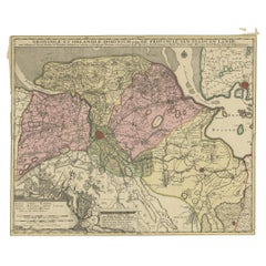
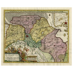
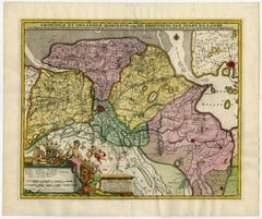
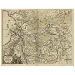
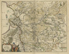
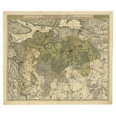
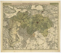
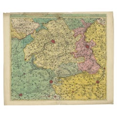
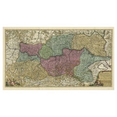
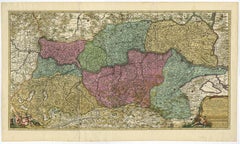
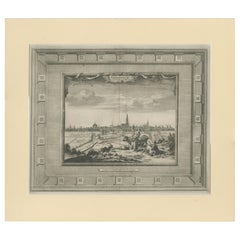
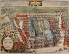
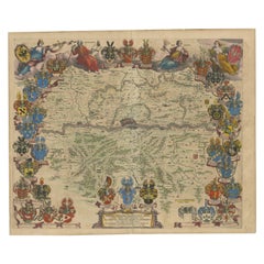
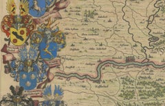
Antique Topographic Maps

to
43
89
24
53
45
30
27
23
15
15
14
11
11
10
8
5
4
4
4
4
4
3
2
2
2
2
2
2
1
1
1
1
1
1
1
1
1
1
7
4
1
1
1
Rare 1888 Utah Map – The Beehive State’s Railroads, Counties & Great Salt Lake

Rare 1888 Utah Map – The Beehive State’s Railroads, Counties & Great Salt Lake

Located in Langweer, NL

, giving the map depth and topographic clarity. The historical significance of this map lies in its timing

Category

Late 19th Century American Antique Topographic Maps

Materials

Paper

Original Antique Hand-Colored Map of Friesland by C. Merian, 1659

Original Antique Hand-Colored Map of Friesland by C. Merian, 1659

Located in Langweer, NL

their artistry and precision. His works include a vast series of topographical studies and maps known

Category

Mid-17th Century Antique Topographic Maps

Materials

Paper

Northern Schleswig and Haderslev Map by Johannes Mejer and Johannes Blaeu, 1662

Northern Schleswig and Haderslev Map by Johannes Mejer and Johannes Blaeu, 1662

Located in Langweer, NL

, a common feature in navigation maps of the time. 4. Topographical Details: - The map includes

Category

1660s Antique Topographic Maps

Materials

Paper

Antique Map of the Rhine centered on Cologne, Germany, with outline coloring

Antique Map of the Rhine centered on Cologne, Germany, with outline coloring

$459Sale Price|20% Off

H 21.58 in W 26.15 in D 0.02 in

Antique Map of the Rhine centered on Cologne, Germany, with outline coloring

Located in Langweer, NL

topographic information, the map names hundreds of cities, towns, rivers and lakes. Putti display coats of

Category

Early 18th Century Antique Topographic Maps

Materials

Paper

Antique Map of the Province of Groningen in the Netherlands, c.1700

Antique Map of the Province of Groningen in the Netherlands, c.1700

Located in Langweer, NL

interests as print sellers, publishers of books, maps, topographical and architectural drawings and globes

Category

18th Century Antique Topographic Maps

Materials

Paper

Mythical Atlantis Restored - A 1694 Map of the Americas and Ancient Geography

Mythical Atlantis Restored - A 1694 Map of the Americas and Ancient Geography

$1,846Sale Price|20% Off

H 15.52 in W 21.5 in D 0.01 in

Mythical Atlantis Restored - A 1694 Map of the Americas and Ancient Geography

Located in Langweer, NL

geographical knowledge. The map is purely topographical, focusing on landforms without providing detailed

Category

1690s Antique Topographic Maps

Materials

Paper

Original Antique Map of the Province of Utrecht, the Netherlands, ca.1720

Original Antique Map of the Province of Utrecht, the Netherlands, ca.1720

Located in Langweer, NL

wide range of interests as print sellers, publishers of books, maps, topographical and architectural

Category

1720s Antique Topographic Maps

Materials

Paper

Decorative Hand-Colored Antique Map of Groningen in the Netherlands, ca.1730

Decorative Hand-Colored Antique Map of Groningen in the Netherlands, ca.1730

$1,195Sale Price|20% Off

H 21.66 in W 25.71 in D 0 in

Decorative Hand-Colored Antique Map of Groningen in the Netherlands, ca.1730

Located in Langweer, NL

wide range of interests as print sellers, publishers of books, maps, topographical and architectural

Category

1730s Antique Topographic Maps

Materials

Paper

Highly Detailed Antique Map of Brabant, Province of the Netherlands, ca.1700

Highly Detailed Antique Map of Brabant, Province of the Netherlands, ca.1700

$1,099Sale Price|20% Off

H 20.95 in W 24.41 in D 0 in

Highly Detailed Antique Map of Brabant, Province of the Netherlands, ca.1700

Located in Langweer, NL

, publishers of books, maps, topographical and architectural drawings and globes. Although they produced some

Category

Early 1700s Antique Topographic Maps

Materials

Paper

Attractive Original Map of the Province of Overijssel, the Netherlands, Ca.1700

Attractive Original Map of the Province of Overijssel, the Netherlands, Ca.1700

Located in Langweer, NL

long period with a wide range of interests as print sellers, publishers of books, maps, topographical

Category

Early 1700s Antique Topographic Maps

Materials

Paper

Daniae Regni & Oldenburg – Antique Maps of Denmark and Saxony by Ortelius, 1598

Daniae Regni & Oldenburg – Antique Maps of Denmark and Saxony by Ortelius, 1598

Located in Langweer, NL

islands. Although the map lacks extensive topographical detail, the inclusion of stippled seas and ornate

Category

16th Century European Antique Topographic Maps

Materials

Paper

1847 Antique Map of Mexico, Texas and California by Samuel Augustus Mitchell

1847 Antique Map of Mexico, Texas and California by Samuel Augustus Mitchell

By Samuel Augustus Mitchell 1

Located in Colorado Springs, CO

features, however he does offer topographical detail in the inset map and profile of roads to Vera Cruz

Category

1840s American Antique Topographic Maps

Materials

Paper

Map of The Italian Peninsula with the islands of Sicily, Sardinia, Corsica, 1880

Map of The Italian Peninsula with the islands of Sicily, Sardinia, Corsica, 1880

Located in Langweer, NL

. **Topographical Detail**: The map shows the topography of Italy, including the Apennine mountain range, the Po

Category

1880s Antique Topographic Maps

Materials

Paper

Antique Map of Java in The Dutch East Indies, Now Indonesia, c.1690

Antique Map of Java in The Dutch East Indies, Now Indonesia, c.1690

$2,630Sale Price|20% Off

H 21.66 in W 18.12 in D 0 in

Antique Map of Java in The Dutch East Indies, Now Indonesia, c.1690

Located in Langweer, NL

, publishers of books, maps, topographical and architectural drawings and globes. Although they produced some

Category

17th Century Antique Topographic Maps

Materials

Paper

Hand-Colored Dutch Map of Ancient Israel Divided by the Twelve Tribes – c.1730

Hand-Colored Dutch Map of Ancient Israel Divided by the Twelve Tribes – c.1730

Located in Langweer, NL

shown. The left portion of the map includes attractive topographical details such as stylized mountain

Category

Early 18th Century Dutch Antique Topographic Maps

Materials

Paper

Antique Map of Flanders, France Incl the Cities Lille, Tournai, Douai, c.1730

Antique Map of Flanders, France Incl the Cities Lille, Tournai, Douai, c.1730

Located in Langweer, NL

, topographical and architectural drawings and globes. Although they produced some original maps, most of their

Category

18th Century Antique Topographic Maps

Materials

Paper

Map of Gard France with Pont du Gard and Wine Regions by Vuillemin, 19th c

Map of Gard France with Pont du Gard and Wine Regions by Vuillemin, 19th c

Located in Langweer, NL

Title: Map of Gard France with Pont du Gard and Wine Regions by Vuillemin, 19th c Description

Category

Mid-19th Century French Antique Topographic Maps

Materials

Paper

Old Map of the Moluccas, Known as the Famous Spice Islands, Indonesia, ca.1730

Old Map of the Moluccas, Known as the Famous Spice Islands, Indonesia, ca.1730

Located in Langweer, NL

long period with a wide range of interests as print sellers, publishers of books, maps, topographical

Category

1730s Antique Topographic Maps

Materials

Paper

Spectacular Large Map of Upper and Lower Austria between Passau and Wien, c.1700

Spectacular Large Map of Upper and Lower Austria between Passau and Wien, c.1700

Located in Langweer, NL

, publishers of books, maps, topographical and architectural drawings and globes. Although they produced some

Category

Early 1700s Antique Topographic Maps

Materials

Paper

Ancient Cartography of Britannia and Hibernia, Published in 1880

Ancient Cartography of Britannia and Hibernia, Published in 1880

$353Sale Price|20% Off

H 18.51 in W 15.56 in D 0 in

Ancient Cartography of Britannia and Hibernia, Published in 1880

Located in Langweer, NL

tribes. In the main section of the map, Great Britain is depicted in fine detail, with topographical

Category

1880s Antique Topographic Maps

Materials

Paper

Turkey in Asia: Biblical Regions and the Holy Land from The Royal Atlas (1856)

Turkey in Asia: Biblical Regions and the Holy Land from The Royal Atlas (1856)

$631Sale Price|20% Off

H 22.96 in W 18.63 in D 0.02 in

Turkey in Asia: Biblical Regions and the Holy Land from The Royal Atlas (1856)

Located in Langweer, NL

This antique map titled "Turkey in Asia (Biblical Regions) The Holy Land and its Borders" comes

Category

Mid-19th Century Antique Topographic Maps

Materials

Paper

Levant in Antiquity: Lands of Phoenicia, Judea, and Neighboring Kingdoms, 1880

Levant in Antiquity: Lands of Phoenicia, Judea, and Neighboring Kingdoms, 1880

Located in Langweer, NL

The map is titled "PHOENICE, COELESYRIA, IDUMAEA, JUDAEA MACCABAEORUM TEMPORE," which translates to

Category

1880s Antique Topographic Maps

Materials

Paper

North African Coasts: Marmarica to Mauretania in Roman Times, Published in 1880

North African Coasts: Marmarica to Mauretania in Roman Times, Published in 1880

$331Sale Price|25% Off

H 15.56 in W 18.51 in D 0.01 in

North African Coasts: Marmarica to Mauretania in Roman Times, Published in 1880

Located in Langweer, NL

sense, not the continent as a whole), Numidia, and Mauretania. 2. **Topographical Details**: The map

Category

1880s German Antique Topographic Maps

Materials

Paper

Ancient Realms of Northeast Africa: Arabia, Ethiopia, and Egypt, Published 1880

Ancient Realms of Northeast Africa: Arabia, Ethiopia, and Egypt, Published 1880

Located in Langweer, NL

civilizations that thrived in these regions. 5. **Topographical Features**: The map shows the varied landscapes

Category

1880s German Antique Topographic Maps

Materials

Paper

Toledo 1902: A Historical Cartographic Study of this Spanish Province

Toledo 1902: A Historical Cartographic Study of this Spanish Province

$315Sale Price|20% Off

H 14.77 in W 20.08 in D 0 in

Toledo 1902: A Historical Cartographic Study of this Spanish Province

Located in Langweer, NL

The print is a historical map of the province of Toledo from 1902. It's a detailed, colored map

Category

Early 1900s Antique Topographic Maps

Materials

Paper

Isles of Enchantment: The Balearic Archipelago in 1902

Isles of Enchantment: The Balearic Archipelago in 1902

$660Sale Price|20% Off

H 14.77 in W 20.08 in D 0 in

Isles of Enchantment: The Balearic Archipelago in 1902

Located in Langweer, NL

The Balearic Islands, Spain, from the year 1902. The title on the map is "ISLAS BALEARES 1902

Category

Early 1900s Antique Topographic Maps

Materials

Paper

Framed View of the Brouwersgracht in Amsterdam, the Netherlands, 1708

Framed View of the Brouwersgracht in Amsterdam, the Netherlands, 1708

$411Sale Price|20% Off

H 12.8 in W 13.59 in D 0.99 in

Framed View of the Brouwersgracht in Amsterdam, the Netherlands, 1708

Located in Langweer, NL

, publishers of books, maps, topographical and architectural drawings and globes. Although they produced some

Category

Early 1700s Antique Topographic Maps

Materials

Paper

Islands of Fire and Whispers: The Canary Islands in 1902

Islands of Fire and Whispers: The Canary Islands in 1902

$353Sale Price|20% Off

H 14.77 in W 20.08 in D 0 in

Islands of Fire and Whispers: The Canary Islands in 1902

Located in Langweer, NL

This is a authentic historical map of the Canary Islands, specifically the "1A HOJA" or first sheet

Category

Early 1900s Antique Topographic Maps

Materials

Paper

Geological Map of the British Isles by A.K. Johnston – Highlands & Valleys 1852

Geological Map of the British Isles by A.K. Johnston – Highlands & Valleys 1852

Located in Langweer, NL

topographic map titled "The Mountains, Table Lands, Plains & Valleys of the British Isles" was created by

Category

Mid-19th Century Scottish Antique Topographic Maps

Materials

Paper

Geological Map of North America by A.K. Johnston – Mountains and Valleys 1852

Geological Map of North America by A.K. Johnston – Mountains and Valleys 1852

Located in Langweer, NL

cartography in the 19th century. The map presents the topographic structure of the North American continent

Category

Mid-19th Century Scottish Antique Topographic Maps

Materials

Paper

Groningen Across the Fields — Elegant Dutch City View by van der Aa, c.1710

Groningen Across the Fields — Elegant Dutch City View by van der Aa, c.1710

Located in Langweer, NL

, one of the most prolific and influential publishers of maps and topographical views in the late 17th

Category

Early 18th Century Dutch Antique Topographic Maps

Materials

Paper

Antique Print of Fortress Nieuwersluis in the Netherlands, 1719

Antique Print of Fortress Nieuwersluis in the Netherlands, 1719

$248Sale Price|20% Off

H 6.89 in W 9.06 in D 0 in

Antique Print of Fortress Nieuwersluis in the Netherlands, 1719

Located in Langweer, NL

topographical prints and maps. Condition: Very good, general age-related toning. Blank verso. Please study

Category

18th Century Antique Topographic Maps

Materials

Paper

Antique Print of Estate Wallestein Near Utrecht, the Netherlands, 1719

Antique Print of Estate Wallestein Near Utrecht, the Netherlands, 1719

$267Sale Price|20% Off

H 8.27 in W 10.24 in D 0 in

Antique Print of Estate Wallestein Near Utrecht, the Netherlands, 1719

Located in Langweer, NL

. Bastiaan worked mostly in the circle of Nicolaes Visscher. Daniel engraved topographical prints and maps

Category

18th Century Antique Topographic Maps

Materials

Paper

Antique Print of Estate Vijverhof by Stoopendaal, 1719

Antique Print of Estate Vijverhof by Stoopendaal, 1719

$267Sale Price|20% Off

H 7.49 in W 10.24 in D 0 in

Antique Print of Estate Vijverhof by Stoopendaal, 1719

Located in Langweer, NL

the circle of Nicolaes Visscher. Daniel engraved topographical prints and maps. Condition: Good

Category

18th Century Antique Topographic Maps

Materials

Paper

Antique Print of Gibraltar, c.1720

Antique Print of Gibraltar, c.1720

$420Sale Price|20% Off

H 6.3 in W 8.08 in D 0 in

Antique Print of Gibraltar, c.1720

Located in Langweer, NL

wide range of interests as print sellers, publishers of books, maps, topographical and architectural

Category

18th Century Antique Topographic Maps

Materials

Paper

Antique Print of the 'Haarlemmerpoort' in Amsterdam City, the Netherland, C.1708

Antique Print of the 'Haarlemmerpoort' in Amsterdam City, the Netherland, C.1708

Located in Langweer, NL

print sellers, publishers of books, maps, topographical and architectural drawings and globes

Category

18th Century Antique Topographic Maps

Materials

Paper

Antique Print of the Nes or Realeneiland by Stoopendaal, 1719

Antique Print of the Nes or Realeneiland by Stoopendaal, 1719

Located in Langweer, NL

engraved topographical prints and maps. Condition: Very good, general age-related toning. Blank verso

Category

18th Century Antique Topographic Maps

Materials

Paper

Japanese Children with Tortoise

Japanese Children with Tortoise

By Harry Humphrey Moore

Located in New York, NY

topographical artist and explorer who mapped the Japanese coast in 1855; and the Boston landscapist

Category

Late 19th Century Antique Topographic Maps

Materials

Oil, Wood Panel

Interior of a Japanese House

Interior of a Japanese House

By Harry Humphrey Moore

Located in New York, NY

topographical artist and explorer who mapped the Japanese coast in 1855; and the Boston landscapist

Category

Late 19th Century Antique Topographic Maps

Materials

Oil, Wood Panel

Japanese Girl Promenading

Japanese Girl Promenading

By Harry Humphrey Moore

Located in New York, NY

topographical artist and explorer who mapped the Japanese coast in 1855; and the Boston landscapist

Category

Late 19th Century Antique Topographic Maps

Materials

Oil, Wood Panel

Japanese Tea Garden
Japanese Tea Garden

Japanese Tea Garden

By Harry Humphrey Moore

Located in New York, NY

topographical artist and explorer who mapped the Japanese coast in 1855; and the Boston landscapist

Category

Late 19th Century Antique Topographic Maps

Materials

Oil, Wood Panel

  • 1
Get Updated with New Arrivals
Save "Antique Topographic Maps", and we’ll notify you when there are new listings in this category.

Antique Topographic Maps For Sale on 1stDibs

An assortment of antique topographic maps is available at 1stDibs. Each of these unique antique topographic maps was constructed with extraordinary care, often using paper, copper and metal. Antique topographic maps have long been popular, with older editions for sale from the 18th Century and newer versions made as recently as the 20th Century. Antique topographic maps have been a part of the life’s work for many furniture makers, but those produced by George Endicott are consistently popular.

How Much are Antique Topographic Maps?

Prices for antique topographic maps start at $395 and top out at $55,000 with the average selling for $765.

Read More

Dickens Fan on Your List? This First Edition of ‘A Christmas Carol’ Is a Treasure

Produced in 1843, the well-preserved volume is evidence of the author's exacting specifications.

Patchwork Quilts Are the Latest Nostalgic Design Trend

New or old, the coverlets add old-time charm to any space.

Medal-Worthy Memorabilia from Epic Past Olympic Games

Get into the games! These items celebrate the events, athletes, host countries and sporting spirit.

Ahoy! You’ve Never Seen a Collection of Sailor Art and Kitsch Quite Like This

French trendsetter and serial collector Daniel Rozensztroch tells us about his obsession with objects related to seafaring men.

39 Incredible Swimming Pools

It's hard to resist the allure of a beautiful pool. So, go ahead and daydream about whiling away your summer in paradise.

Pamela Shamshiri Shares the Secrets behind Her First-Ever Book and Its Effortlessly Cool Interiors

The sought-after designer worked with the team at Hoffman Creative to produce a monograph that beautifully showcases some of Studio Shamshiri's most inspiring projects.

Moroccan Artworks and Objects Take Center Stage in an Extraordinary Villa in Tangier

Italian writer and collector Umberto Pasti opens the doors to his remarkable cave of wonders in North Africa.

Montecito Has Drawn Royalty and Celebrities, and These Homes Are Proof of Its Allure

Hollywood A-listers, ex-pat aristocrats and art collectors and style setters of all stripes appreciate the allure of the coastal California hamlet — much on our minds after recent winter floods.