Items Similar to Antique Print of Fortress Nieuwersluis in the Netherlands, 1719

Want more images or videos?
Request additional images or videos from the seller
1 of 6
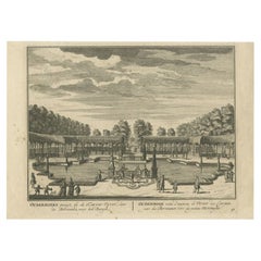
Antique Print of Fortress Nieuwersluis in the Netherlands, 1719
About the Item
Antique print titled 'De Schans Nieuwersluis (..)'. This print shows fortress Nieuwersluis, as seen towards Ouderhoek. With draw bridge over the Vecht river. Originates from 'De Zegepraalende Vecht, vertoonende verscheidene Gesichten van Lustplaatsen, Heeren Huysen en dorpen, beginnen van Uitrecht en met Muyden besluytende' published in Amsterdam by Andries de Leth / Wed. Nicolaas Visscher, 1719.
Artists and Engravers: Daniel Stoopendaal (Dutch) was active in Amsterdam from 1685 to 1713. Both Daniel and Bastiaan Stoopendaal made maps for the so-called Keur Bibles (published from 1666-1756). Most probably both were not related. Bastiaan worked mostly in the circle of Nicolaes Visscher. Daniel engraved topographical prints and maps.
Condition: Very good, general age-related toning. Blank verso. Please study image carefully.
Date: 1719
Overall size: 23 x 17.5 cm.
Image size: 19.5 x 14.5 cm.
We sell original antique maps to collectors, historians, educators and interior decorators all over the world. Our collection includes a wide range of authentic antique maps from the 16th to the 20th centuries. Buying and collecting antique maps is a tradition that goes back hundreds of years. Antique maps have proved a richly rewarding investment over the past decade, thanks to a growing appreciation of their unique historical appeal. Today the decorative qualities of antique maps are widely recognized by interior designers who appreciate their beauty and design flexibility. Depending on the individual map, presentation, and context, a rare or antique map can be modern, traditional, abstract, figurative, serious or whimsical. We offer a wide range of authentic antique maps for any budget.
- Dimensions:Height: 6.89 in (17.5 cm)Width: 9.06 in (23 cm)Depth: 0 in (0.01 mm)
- Materials and Techniques:
- Period:
- Date of Manufacture:1719
- Condition:Condition: Very good, general age-related toning. Blank verso. Please study image carefully.
- Seller Location:Langweer, NL
- Reference Number:
About the Seller
5.0
Platinum Seller
These expertly vetted sellers are 1stDibs' most experienced sellers and are rated highest by our customers.
Established in 2009
1stDibs seller since 2017
1,932 sales on 1stDibs
Typical response time: <1 hour
- ShippingRetrieving quote...Ships From: Langweer, Netherlands
- Return PolicyA return for this item may be initiated within 14 days of delivery.
More From This SellerView All
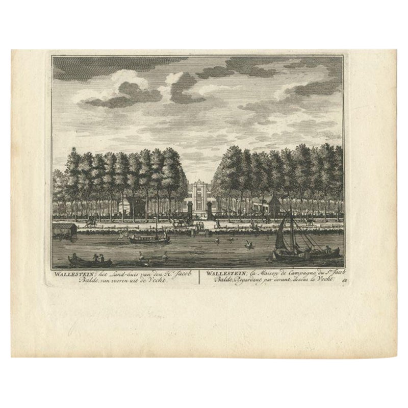
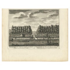
- Antique Print of Estate Wallestein Near Utrecht, the Netherlands, 1719Located in Langweer, NLAntique print titled 'Wallestein; het Land-huis van den Hr. Jacob Balde (..)'. This print shows Wallestein, the estate of Mr. Jacob Balde. Originates from 'De Zegepraalende Vecht, vertoonende verscheidene Gesichten van Lustplaatsen, Heeren Huysen en dorpen, beginnen van Uitrecht en met Muyden besluytende' published in Amsterdam by Andries de Leth / Wed. Nicolaas Visscher, 1719. Artists and Engravers: Daniel Stoopendaal (Dutch) was active in Amsterdam from 1685 to 1713. Both Daniel and Bastiaan Stoopendaal made maps for the so-called Keur Bibles (published from 1666-1756). Most probably both were not related. Bastiaan worked mostly in the circle of Nicolaes Visscher. Daniel engraved topographical prints...Category
Antique 18th Century Prints
MaterialsPaper
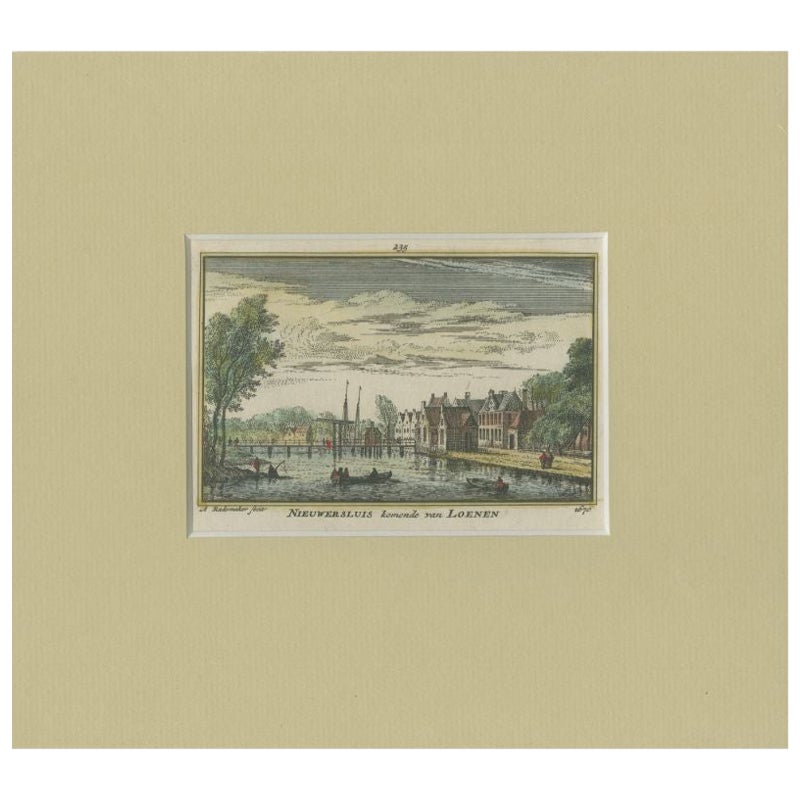
- Antique Print of the Village of Nieuwersluis, C.1730By Abraham RademakerLocated in Langweer, NLAntique print titled 'Nieuwersluis komende van Loenen'. View of the village of Nieuwersluis, the Netherlands. This print originates from 'Kabinet van Nederlandsche en Kleefsche outhe...Category
Antique 18th Century Prints
MaterialsPaper
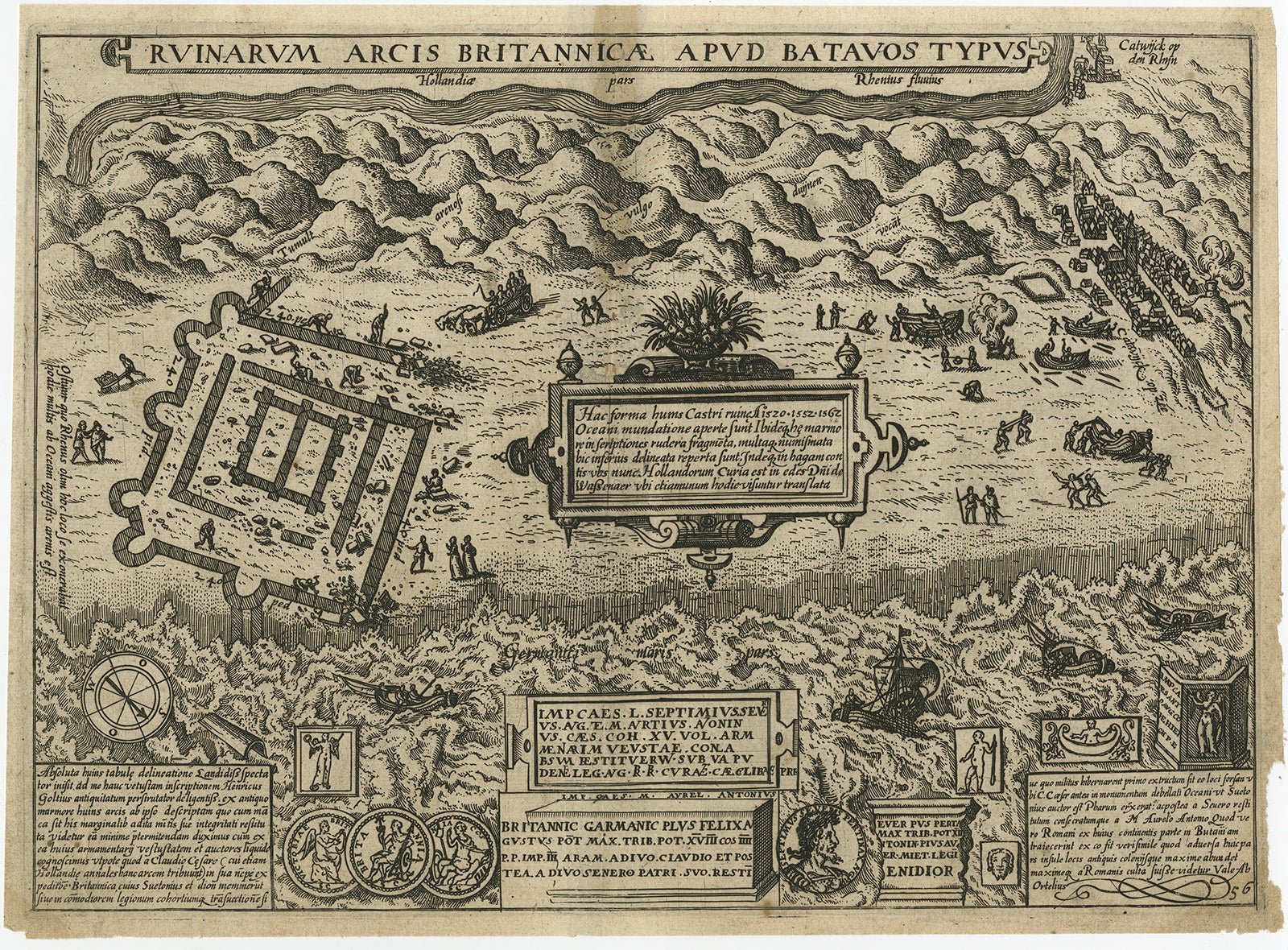
- Antique Print of the Ruins of the Roman Fortress Brittenburg, The NetherlandsBy L. GuicciardiniLocated in Langweer, NLThe ruins of the Roman fortress Brittenburg near Katwijk, The Netherlands. Made by 'Ludovico Guicciardini' after an anonymous artist. Lodovico Guicciardini (19 August 1521-22 March 1...Category
Antique Early 17th Century Prints
MaterialsPaper
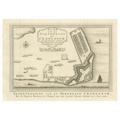
- Antique Print of the Kodungallur Fortress, IndiaBy Jakob van der SchleyLocated in Langweer, NLAntique print titled 'Grondtekening van de Fortresse Cranganor, met de buyten-werken, en 't Project van een nieuwe Schans, Gedaan in 't Jaar 1709'. Floor plan of the Kodungallur Fortress, India. Kottappuram Fort, built by the Portuguese in 1523 was referred to popularly as Cranganore Fort and is now known as Kodungallur Fort. It was captured and destroyed by the Dutch in 1663. The Fort had a strategic position, on the mouth of the river Periyar before it joins the Arabian Sea, which gave it the advantage of controlling the ships and boats...Category
Antique Mid-18th Century Prints
MaterialsPaper
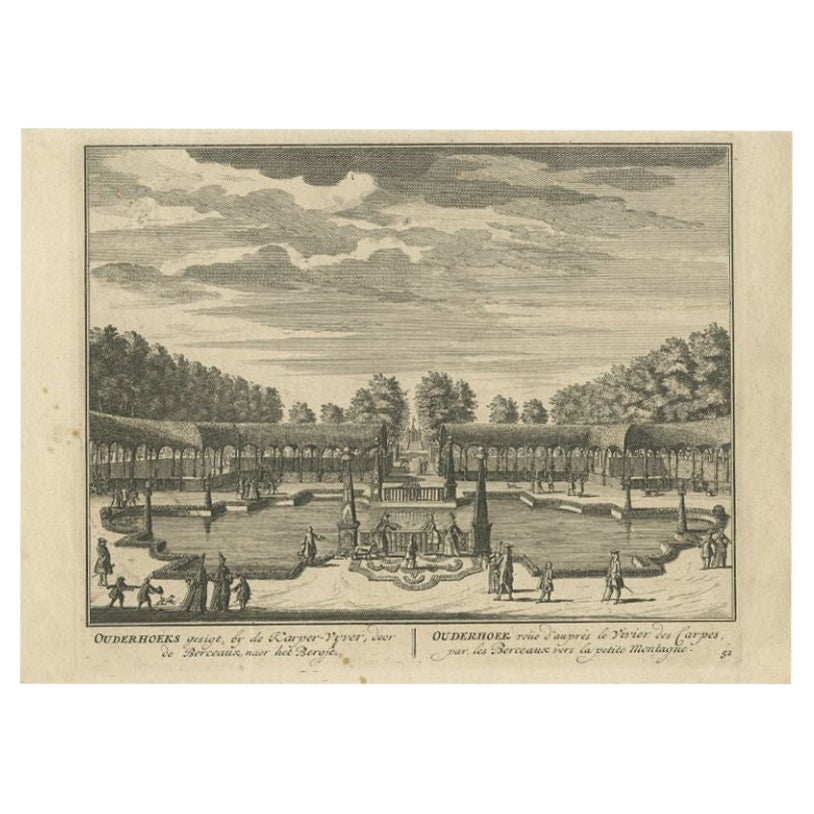
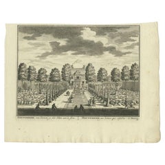
- Antique Print of the 'Ouderhoek' Estate by Stoopendaal, 1719Located in Langweer, NLAntique print titled 'Ouderhoeks, gesigt, bij de Karper-Vyver, door de Berceaux naer het Bergje'. Depicts Ouderhoek, the estate of Mr. Anthonie van den Hoek. Originates from 'De zege...Category
Antique 18th Century Prints
MaterialsPaper
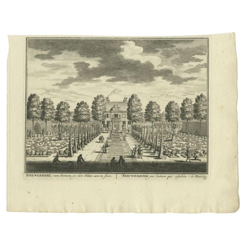
- Antique Print of the 'Nieuwerhoek' Estate by Stoopendaal, 1719Located in Langweer, NLAntique print Loenen titled 'Nieuwerhoek van binnen, op het Huis aen te sien'. Depicts Nieuwerhoek, the estate of Mr. Jan van Tarelink. Originates from 'De zegepralende Vecht', 1719....Category
Antique 18th Century Prints
MaterialsPaper

You May Also Like
- Pair of Bernard De Montfaucon Paris 1719 L'antiquite Original Grand Tour PrintsBy Bernard de MontfaucaonLocated in GBWe are delighted to offer for sale this lovely pair of original copper plate prints dating to 1719 by Bernard De Montfauucon of Paris. Dom Bernard de Montfaucon, O.S.B. (French: [d? m?~fok?~]; 13 January 1655 – 21 December 1741) was a French Benedictine monk of the Congregation of Saint Maur. He was an astute scholar who founded the discipline of palaeography, as well as being an editor of works of the Fathers of the Church. He is regarded as one of the founders of the modern discipline of archaeology Montfaucon was born on 13 January 1655 in the Castle of Soulatgé, a small village in the southern town of Corbières, then in the ancient Province of Languedoc, now in the modern Department of Aude. Other sources claimed his birth date is in 16 January, the most accepted date. After one year he was moved to the Castle of Roquetaillade, residence of his family. When he was seven, he was sent to Limoux, to the college run by the Fathers of Christian Doctrine Montfaucon served in the French army as a volunteer and participated in the Franco-Dutch War of 1673. He was a captain of grenadiers and made two campaigns under the command of Marshall Turenne, participated in the Battle of Herbsthausen and fell ill in Saverne in Alsace. Because of his infectious illness he made a vow to Our Lady of Marceille to give one hundred livres to her sanctuary in Limoux and to become a monk, if he was able to return to his country as a result of her intervention. After the death of Montfaucon's father at the Château de Roquetaillade, in 1675 he entered the novitiate of the Benedictine monastery of Bream in Toulouse. There he learned several ancient languages: Greek, Hebrew, Chaldean, Syriac, and Coptic. In 1687 Montfaucon was called to the Abbey of Saint-Germain-des-Prés and he started to work on an edition of the works of the Greek Church...Category
Antique 1710s French Grand Tour Prints
MaterialsWood, Paper
- Original Antique Map of The Netherlands, Engraved by Barlow, Dated 1807Located in St Annes, LancashireGreat map of Netherlands Copper-plate engraving by Barlow Published by Brightly & Kinnersly, Bungay, Suffolk. Dated 1807 Unframed.Category
Antique Early 1800s English Maps
MaterialsPaper
- Original Antique Map of The Netherlands, Sherwood, Neely & Jones, Dated 1809Located in St Annes, LancashireGreat map of The Netherlands Copper-plate engraving by Cooper Published by Sherwood, Neely & Jones. Dated 1809 Unframed.Category
Antique Early 1800s English Maps
MaterialsPaper
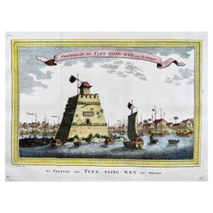
- Prevost; Schley, Fortress on the Beijing River, ChinaBy PrevostLocated in Norwich, GBForteresse de Tyen Tsing Wey, tiree de Nieuhof Published ca 1755. Fine hand colour. Rare original copper plate engraved antique print the Fortress (long ago demolished) guarding the cross roads of the meeting of the major rivers in Beijing (Peking) by Jakob van Schley - after Nieuhoff - in 1755 and published in Antoine François Prevost’s 15 volumes of Histoire Generale des Voyages written by Prevost & other authors between 1746-1789. Several major rivers, including the Yongding, Chaobai, Juma and Wenyu flow through Beijing Municipality. They originate in the highlands of Hebei and Shanxi, cut through the mountains west...Category
Antique 1750s Chinese Georgian Prints
MaterialsPaper
- Antique Dutch Prints of the Four ContinentsLocated in Tampa, FLTwo prints of the four continents they are early 19th century, Dutch. In antique hand carved water gilded frames with original glass.Category
Antique Early 19th Century Prints
MaterialsPaper
- Original Antique Print of a Chinese Actor in the San Francisco TheatreLocated in St Annes, LancashireGreat image of a Chinese actor in the San Francisco Theatre Woodcut engraving Text on verso Published circa 1890 Free shipping.Category
Antique 1890s English Folk Art Prints
MaterialsPaper


Recently Viewed
View AllMore Ways To Browse
Rare Antique Bible
Image Fortress
Neoclassical French Lighting
Vintage And Primitives
Vintage Paris Market
Human Chair
20 Mid Century Chairs
Danish Glass Lamp
Fluted Band
Two Door Cabinet On Legs
Chrome Metal And Leather
Vintage Marble And Brass Table
Antique Under 100
Brown And White Vase
Phone Stand
Vintage Pink Rose
Brown And White Vases
Chair Mind