
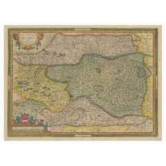
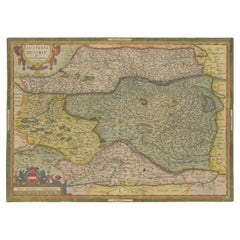
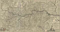
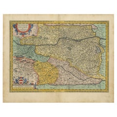
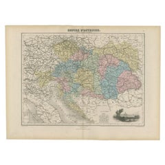
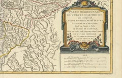
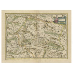
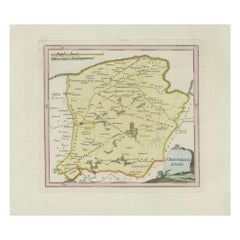
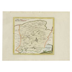
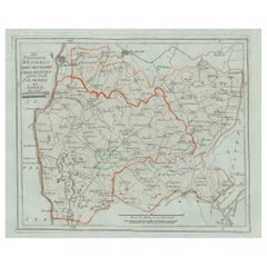
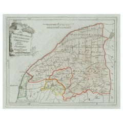
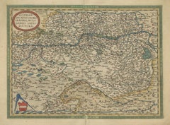
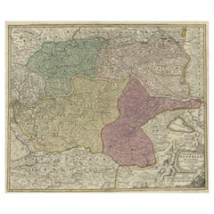
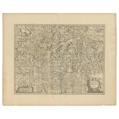
Antique Map of Austria by Clouet '1787'
Located in Langweer, NL
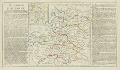
Antique map titled 'Le Cercle d'Autriche'. Antique map of Austria.
Category
Antique Late 18th Century Maps
Materials
Paper
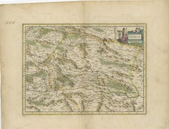
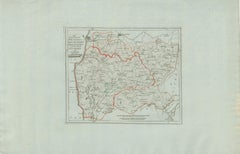
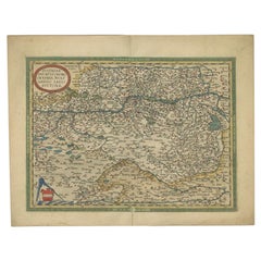
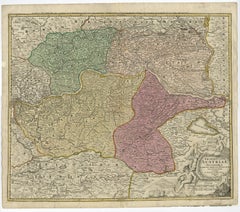
Antique Map of Austria by Clouet '1787'
Located in Langweer, NL
Antique map titled 'Le Cercle d'Autriche'. Antique map of Austria.
Paper
$93Sale Price|20% Off
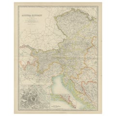
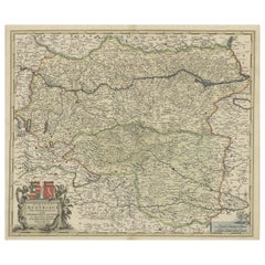
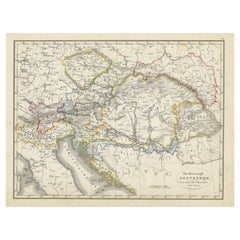
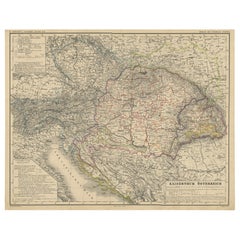
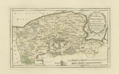
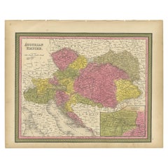
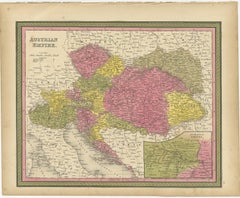
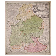
Antique Map of Austria by Lowry, 1852
Located in Langweer, NL
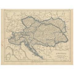
Antique map titled 'Austria'. Original map of Austria. This map originates from 'Lowry's Table Atlas constructed and engraved from the most recent Authorities' by J.W.
Paper
$232Sale Price|20% Off
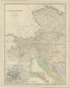
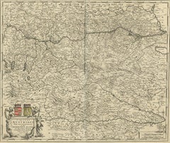
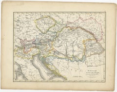
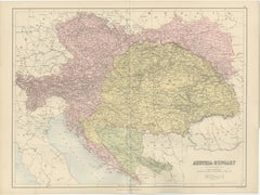
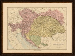
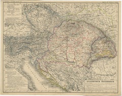
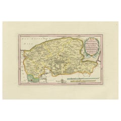
Antique Map of Austria- Hungary by Johnston, '1909'
Located in Langweer, NL
Antique map titled 'Austria- Hungary'. Original antique map of Austria- Hungary.
Paper
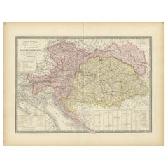
$302Sale Price|35% Off
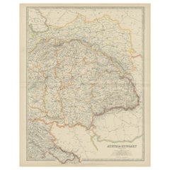
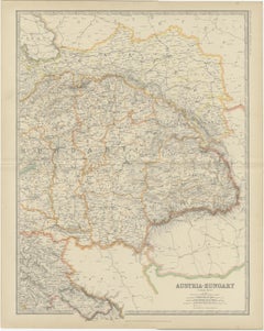
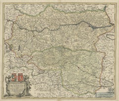
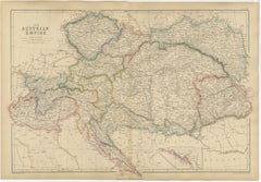
Antique Map of Austria-Hungary by Levasseur, '1875'
Located in Langweer, NL
Large map of Austria-Hungary. This map originates from 'Atlas de Géographie Moderne Physique et Politique' by A.
Paper
$232Sale Price|20% Off
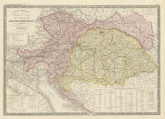
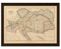
Antique Map of Austria- Hungary by Johnston '1909'
Located in Langweer, NL
Antique map titled 'Austria- Hungary'. Original antique map of Austria- Hungary.
Paper
$163Sale Price|20% Off
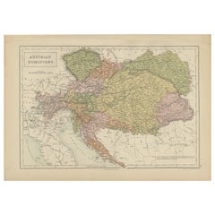
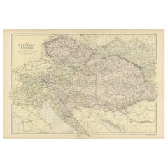
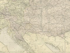
Antique Map of Austrian Dominions by A & C. Black, 1870
Located in Langweer, NL
Antique map titled 'Austrian Dominions'. Original antique map of Austrian Dominions.
Paper
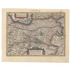
Antique Map of Austria by Ortelius, c.1612
Located in Langweer, NL
Antique map titled 'Austriae Descrip. per Wolfgangum Lazium' Original antique map of Austria.
Paper
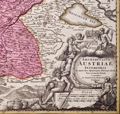
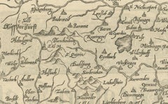
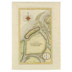
Antique Map of Austria, Centered Around the Danube from Passau to Vienna, C.1690
Located in Langweer, NL
Detailed map of Austria, centered on the course of the Danube from Passau to Vienna.
Paper

Decorative Antique Map of Austria – Frederick de Wit, Amsterdam c.1690
Located in Langweer, NL
Antique Map of Austria – “Circuli Austriaci pars Septentrionalis” by F. de Wit, c.1670 This finely engraved map, titled “Circuli Austriaci pars Septentrionalis in qua Archiducatus A...
Paper


Hand Colored 18th Century Homann Map of Austria Including Vienna and the Danube
By Johann Baptist Homann
Located in Alamo, CA
"Archiducatus Austriae inferioris" is a hand colored map of Austria created by Johann Baptist Homann (1663-1724) and published in Nuremberg, Germany in 1728 shortly after his death.
Paper

$866Sale Price|20% Off
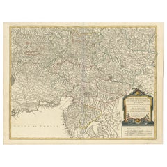
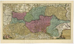
Antique Map of Austria by N. Visscher, circa 1690
Located in Langweer, NL
Spectacular large map of Upper and Lower Austria between Passau and Wien with figurative cartouche and armorial vignette.
Paper
$177Sale Price|20% Off
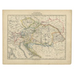
Original Antique Map of Austria from an Old Dutch School Atlas, 1852
Located in Langweer, NL
Antique map titled 'Het Keizerrijk Oostenrijk'. Map of the Austrian Empire.
Paper

Hand Colored 18th Century Homann Map of Austria Including Vienna & the Danube
By Johann Baptist Homann
Located in Alamo, CA
"Archiducatus Austriae inferioris" is a hand colored map of Austria created by Johann Baptist Homann (1663-1724) and published in Nuremberg, Germany in 1728 shortly after his death.
Engraving

$2,049Sale Price|20% Off
Austria by Wolfgang Lazius – A Magnificent 16th-Century Map from Ortelius, 1592
Located in Langweer, NL
Title: Avstriae Descrip – Wolfgang Lazius’ Map of Austria, 16th Century Description: This extraordinary map of Austria pays homage to the Austrian humanist and cartographer Wo...
Paper
$521Sale Price|20% Off
1634 Mercator/Jansson Map: Eastern Austria with Vienna, Hand-Colored
Located in Langweer, NL
1634 Mercator/Jansson Map: Eastern Austria with Vienna, Hand-Colored This hand-colored map from 1634, titled "Austria Archiducatus," by Mercator and Jansson, depicts the eastern reg...
Paper
Antique Austria-Hungary Map, Austro-Hungarian Empire, Bartholomew, 1884
Located in Langweer, NL
Title: Antique Austria-Hungary Map, Austro-Hungarian Empire, Bartholomew 1884 This finely engraved antique map of Austria-Hungary was produced under the direction of the celebrated ...
Paper
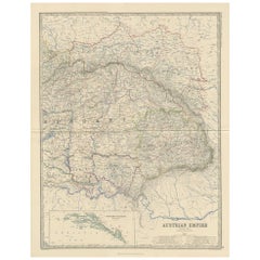
Original Antique Map of the Austrian Empire, Austria-Hungary c.1860
Located in Langweer, NL
Original Antique Map of the Austrian Empire, Austria-Hungary c.1860 This large and highly detailed original antique map depicts the Austrian Empire during the mid-nineteenth century...
Paper
$195Sale Price|20% Off
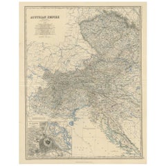
Original Antique Map of The Austrian Empire, 1882
Located in Langweer, NL
Step into the past with an original Antique Map of The Austrian Empire from the esteemed 'Comprehensive Atlas and Geography of the World,' meticulously crafted in 1882.
Paper
$270Sale Price|20% Off
Old German Map of the Austrian Empire, ca.1870
Located in Langweer, NL
Antique map titled 'Kaiserthum Österreich'. Old map of the Austrian Empire.
Paper

$73Sale Price|47% Off
Antique Map of the Austrian Empire by Petri, 1852
Located in Langweer, NL
Antique map titled 'Het Keizerrijk Oostenrijk'. Map of the Austrian Empire.
Paper

$102Sale Price|20% Off
Antique Map of the Austrian Empire by Migeon, 1880
Located in Langweer, NL
Antique map titled 'Empire d'Autriche'. Old map of the Austrian Empire.
Paper

$86Sale Price|20% Off
Antique Map of the Austrian Empire by Petri, c.1873
Located in Langweer, NL
Antique map titled 'Het Keizerrijk Oostenrijk'. Old map depicting the Austrian Empire.
Paper
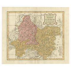

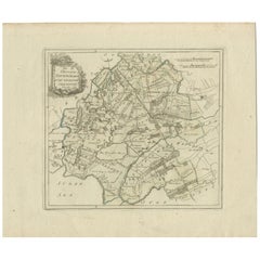
Antique Map of Bavaria in Southern Germany and Austria, 1806
Located in Langweer, NL
Antique map titled 'Cercles de Baviere et d'Autriche.' This map shows Bavaria in southern Germany and Austria.
Paper


Antique Map of Germany with the Empire of Austria by Wyld '1845'
Located in Langweer, NL
Antique map titled 'The Confederated States of Germany with the Empire of Austria, and The Kingdoms of Prussia and Poland'.
Paper
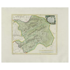
Original 18th-Century Map of Southern Austria, Carinthia, Carniola, and Styria
Located in Langweer, NL
title: 18th-Century Map of Southern Austria, Carinthia, Carniola, and Styria by Robert de Vaugondy Description: This finely engraved 18th-century map by Gilles Robert de Vaugondy ...
Paper

Antique Map of the Region of Bavaria and Austria by Tirion, c.1740
Located in Langweer, NL
Antique map titled 'Carte des environs de Batavia - Kaart van de Buitenstreken van Batavia'. Map of the Batavia area (Jakarta) in Indonesia. With cartouche, scale and compass rose. P...
Paper
$717Sale Price|20% Off
1720 Johann Baptist Homann Map of the Austrian Circle and Surrounding Regions
Located in Langweer, NL
"1720 Johann Baptist Homann Map of the Austrian Circle and Surrounding Regions" This map, crafted by the renowned cartographer Johann Baptist Homann around 1720, is titled "Germania...
Paper
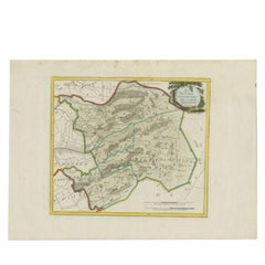
An Original Antique Mid-17th Century Blaeu Map of Styria in Southeastern Austria
Located in Langweer, NL
Overall, the map’s condition is good, and has been well-preserved.
Paper

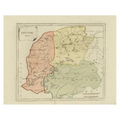
Antique Map of Sneek and Bolsward, Friesland – Dutch Provincial Map, 1791
Located in Langweer, NL
Antique Map of Sneek and Bolsward, Friesland by von Reilly, 1791 Original engraved map titled Der Provinz Westergo drey mittlere Grietenyen, mit der Stadt Bolsward und Sneek No. 641...
Paper
Woodcut Map of the Rhine River Region Covering the Palatinate, Austria and Elsa
Located in Langweer, NL
Early Woodcut Map of the Rhine River Region Covering the Palatinate, Austria, and Elsass, ca. 1628 This early woodcut map, titled "Die ander Tafel des Rheinstromes/begriffen die Pfa...
Paper

Antique General Map of Friesland – Dutch Provincial Map by von Reilly, 1791
Located in Langweer, NL
The map was issued as part of Franz Joseph Johann von Reilly’s *Schauplatz der fünf Theile der Welt* (“Showplace of the Five Parts of the World”), the first Austrian world atlas proj...
Paper
$1,529Sale Price|24% Off
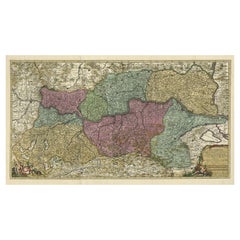
Spectacular Large Map of Upper and Lower Austria between Passau and Wien, c.1700
Located in Langweer, NL
Spectacular large map of Upper and Lower Austria between Passau and Wien with figurative cartouche and armorial vignette.
Paper
Antique Map of the Wadden Islands, 1792
Located in Langweer, NL
Antique map titled 'Der Vlie Strom'. Map of the Wadden islands with Vlieland in the middle (The Netherlands). This map originates from 'Schauplatz der fünf Theile der Welt' published...
Paper

Antique Map of Friesland by Von Reilly, 1791
Located in Langweer, NL
Antique map titled 'Friesland'. Map of the province of Friesland, the Netherlands.
Paper

Antique Map of Zevenwolden by Von Reilly, 1791
Located in Langweer, NL
Friesland Zevenwouden eastern districts map, Reilly, Vienna, c.1791–95 Description: Engraved map with original hand color of the Zevenwouden (Seven Forests) region in Friesland, Net...
Paper

Antique Map of Oostergo, Friesland by von Reilly, 1791
Located in Langweer, NL
Antique Map of Oostergo, Friesland by von Reilly, 1791 Original engraved map titled 'Oostergo No. 643', published in Vienna in 1791.
Paper

Antique Map of Zevenwolden, Friesland by von Reilly, 1791
Located in Langweer, NL
This map is highly desirable for collectors of Dutch provincial cartography and Austrian atlas work.
Paper


Antique Map of the Region of Gaasterland, Friesland, The Netherlands, 1791
Located in Langweer, NL
The engraving work for his maps was carried out by Ignaz Alberti (also known as Ignaz Albrecht, 1760–1794), an Austrian illustrator and engraver.
Paper

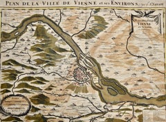
Vienna, Austria: A Large 17th Century Hand-Colored Map by Sanson and Jaillot
By Nicolas Sanson
Located in Alamo, CA
This large 17th century hand-colored map of Vienna, Austria and the surrounding countryside and villages entitled "Plan de la Ville de Vienne en Austriche et ses Environs Par le.
Paper

Antique Map of Oostergo, Friesland, by Von Reilly, 1791
Located in Langweer, NL
His maps were engraved by Ignaz Alberti (also Albrecht, 1760–1794), an Austrian illustrator and engraver known for fine linework and legibility.
Paper

Antique Map of Southern Westergo, Friesland by von Reilly, 1791
Located in Langweer, NL
This map was issued as part of Franz Joseph Johann von Reilly’s *Schauplatz der fünf Theile der Welt* (“Showplace of the Five Parts of the World”), one of the first Austrian atlas pr...
Paper

Antique Map of Eastern Oostergo, Friesland by von Reilly, 1791
Located in Langweer, NL
Antique Map of Eastern Oostergo, Friesland by von Reilly, 1791 Original engraved map titled Der Provinz Oostergo sechs östliche Grietenyen No. 643, published in Vienna in 1791. This...
Paper
Rare 1791 von Reilly Map of Friesland Province, Netherlands, 18th Century
Located in Langweer, NL
Collectors value these maps for their rarity, their historical perspective on Friesland’s geography, and their fine Austrian engraving style.
Paper
Antique Map of Sneek and Surroundings, Friesland by von Reilly, 1791
Located in Langweer, NL
The engraving was executed by Ignaz Alberti (1760–1794), an Austrian illustrator and engraver whose crisp style ensured the maps were both accurate and visually appealing.
Paper

Antique Map of Leeuwarden and Dokkum, Friesland by von Reilly, 1791
Located in Langweer, NL
This finely detailed map originates from Franz Joseph Johann von Reilly’s monumental Schauplatz der fünf Theile der Welt (“Showplace of the Five Parts of the World”), an ambitious la...
Paper

Antique Map of Leeuwarden and Dokkum, Friesland by von Reilly, 1791
Located in Langweer, NL
Antique Map of Leeuwarden and Dokkum, Friesland by von Reilly, 1791 Original engraved map titled Der Provinz Oostergo fünf nördliche Grietenyen, mit der Stadt Leeuwarden und Dokkum ...
Paper

Antique Map of Franeker and Harlingen, Friesland by von Reilly, 1791
Located in Langweer, NL
Antique Map of Franeker and Harlingen, Friesland by von Reilly, 1791 Original engraved map titled Der Provinz Westergo vier nördliche Grietenyen mit der Stadt Franeker und Harlingen...
Paper


Rare 1791 von Reilly Map of Franeker and Harlingen, Friesland, Netherlands
Located in Langweer, NL
An attractive piece for collectors of Dutch provincial maps and Austrian cartography, this map combines both historical and decorative interest.
Paper

Rare Antique Hand-Colored Map of Eastern Friesland by von Reilly, 1791
Located in Langweer, NL
This map was published in Franz Joseph Johann von Reilly’s ambitious atlas *Schauplatz der fünf Theile der Welt* (“Showplace of the Five Parts of the World”), one of the most signifi...
Paper
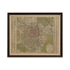
Antique Map of Vienna, Plan von Wien, Hand Colored Artaria City Plan, 1839
Located in Langweer, NL
Keyword block: Vienna map, Wien plan 1839, Artaria map, Austrian city plan, Hofburg Vienna, Danube map, Biedermeier Vienna, antique city map, Vienna suburbs map, 19th century map Aus...
Paper


$419Sale Price|20% Off
Antique Map of Styria by Mercator 'circa 1650'
Located in Langweer, NL
Antique map titled 'Stiria'. Original antique map of Styria, Austria.
Paper


$698Sale Price|20% Off
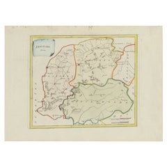
Antique Map of the Region of Salzburg by Ortelius 'circa 1606'
Located in Langweer, NL
Antique map titled 'Salisburgensis Iurisdictionis'. Original antique map of the region of Salzburg, Austria.
Paper

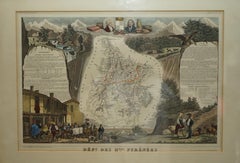
Fine French Antique 1856 Hand Watercolour Map of Dept Des Hautes Pyrenees
Located in West Sussex, Pulborough
We are delighted to offer for sale this stunning 1856 hand watercolour map of the Austrian Alps titled Dept Des Hautes Pyrenees taken from the Atlas National Illustre y Victor Levass...
Paper
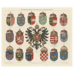
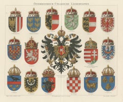
Imperial Austrian and Hungarian Coats of Arms – Antique Print, c.1880
Located in Langweer, NL
Title: Österreichisch-Ungarische Länderwappen – Imperial Coats of Arms of Austria-Hungary, c.1880 This finely detailed chromolithograph, titled Österreichisch-Ungarische Länderwappe...
Paper

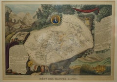
Fine Antique 1856 Hand Watercolour Map of Dept Des Hautes Alpes by Levasseur's
Located in West Sussex, Pulborough
We are delighted to offer for sale this stunning 1856 hand watercolour map of the Austrian Alps titled Dept Des Hautes Alpes taken from the Atlas National Illustre y Victor Levasseur...
Paper

Beautiful Colour French Antique 1856 Hand Watercolour Map of Dept Des La Corse
Located in West Sussex, Pulborough
We are delighted to offer for sale this stunning 1856 hand watercolour map of the Austrian Alps titled Dept Des La Course taken from the Atlas National Illustre y Victor Levasseur ...
Paper
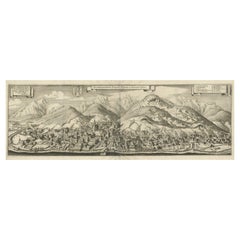

Large Panoramic View of Eisenerz, an Old Mining Town in Styria, Austria, c.1650
Located in Langweer, NL
Description: Antique print titled 'Der weyt berümpte Marckt und Bergwerck Eysenärtz im Hertzogtum Steyer'. Large panoramic view of Eisenerz, an old mining town in the Austrian st...
Paper
Antique Map of Austria and Hungary by Ortelius, c.1590
Located in Langweer, NL
Decorative regional map of Austria and Hungary, following the Danube from Lintz to Bratislava and extending north to the Teya and south to the Dranus.
Paper
Sold
H 20.87 in W 24.02 in D 0 in
Old Decorative Map of Austria, Centered on the Danube River and Vienna, Ca.1720
Located in Langweer, NL
Decorative map of Austria, centered on the course of the Danube River and Vienna.
Paper
Sold
H 13.78 in W 17.13 in D 0 in
Colourful Old Map of the Austrian Empire, with an Inset Map of Vienna, 1846
Located in Langweer, NL
Antique map titled 'Austrian Empire'. Old map of the Austrian Empire, with an inset map of Vienna.
Paper
Antique Map of the Austrian Empire by A.K. Johnston, 1865
Located in Langweer, NL
Antique map titled 'Austrian Empire (Eastern Sheet)'. Depicting Hungary, Servia, Transylvania and more.
Paper
Antique Map of the Austrian Empire ‘West’ by A.K. Johnston, 1865
Located in Langweer, NL
Antique map titled 'Austrian Empire (Western Sheet)'. Depicting Dalmatia, Istria, Croatia, Bohemia and more.
Paper

Sold
H 23.23 in W 15.36 in D 0 in
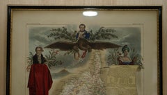
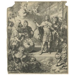
Rare Print of Archduke Charles of Austria Showing California as an Island, 1704
Located in Langweer, NL
Allegorical portrait of the Archduke Charles of Austria (calling himself the Spanish king Charles III) as Roman general, 1704. In the foreground near Neptune, Africa and Asia carry a...
Paper
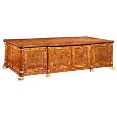
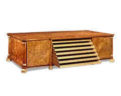
Imperial Map Desk of the Habsburg Empire
Located in New Orleans, LA
This monumental, one-of-a-kind map desk hails from the Imperial Palace of the Habsburg Emperor Franz Joseph I, ruler of both Austria and Hungary from 1848 until 1916.
Satinwood, Walnut, Wood


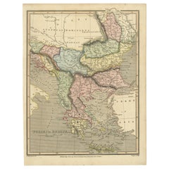
Antique Map of Austria, Turkey and Greece by Johnson, 1872
Located in Langweer, NL
Antique map titled 'Johnson's Austria, Turkey in Europe and Greece'.
Paper
Antique Map of Austria by J. Tallis, circa 1851
Located in Langweer, NL
A highly decorative and finely engraved mid-19th century map of Austria (including Bohemia) that appeared in John Tallis & co.'

Sold
H 20.79 in W 25.2 in D 0.02 in
Antique Map of Austria 'Tirol' with Parts of Italy by J. Janssonius, 1649
Located in Langweer, NL
Antique map titled 'Comitatus Tirolensis'. Relief shown pictorially, decorative cartouche, figures, cherub. Shows topography, waterways, vegetation. Appears in Jansson’s Nieuwen atla...
Paper

19th Century Map Imperial Court of Austria Habsburgs
Located in London, GB
This is an antique map of the State of the Imperial Court and the hereditary states of the House of Austria, with their various chancelleries, circa 1820.

Sold
H 23.63 in W 20.25 in D 0.07 in
Hand Colored 18th C. Homann Map of Bavaria & Portions of Austria and Switzerland
By Johann Baptist Homann
Located in Alamo, CA
This hand colored map of Bavaria in Southern Germany and portions of Austria and Switzerland entitled "Bavariae Circulus et Electorat, in suas quasaque Ditiones tam cum Adjacentibus ...
Paper

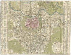
Antique Map of the City of Vienna by Balbi '1847'
Located in Langweer, NL
Antique map titled 'Vienne'. Original antique map of the city of Vienna, Austria.
Paper
Sold
H 10.63 in W 8.04 in D 0 in
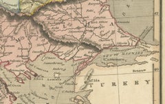
Early 19th Century Map of Ottoman Europe and Surrounding Regions, 1821
Located in Langweer, NL
- Neighboring Regions: To the north, the map depicts parts of the **Austrian Empire** and **Transylvania**, highlighting the geopolitical tensions between the Austro-Hungarian Empi...
Paper


World Map Night Stand Commode
Located in Boca Raton, FL
Custom Made funky cool world map nightstand.
Antique and vintage collectibles and curiosities can bring whimsy and wonder to any interior.
Decorating with old scientific instruments, historical memorabilia and vintage musical instruments, as well as other authentic collectibles and curiosities that can be found on 1stDibs, presents an opportunity to create a unique, natural history museum-like atmosphere in your home that can provoke conversation as often as it pays tribute to how far we’ve come in understanding our world.
And bringing collectibles and curiosities into your space is actually on trend — Wunderkammern, or curiosity cabinets, were all the rage in Europe during the 1500s and continued to have adherents there and in the U.S. in the following centuries. Today, however, they’re experiencing a real surge in popularity and influencing how many interior designers are furnishing and decorating homes — combining contemporary with antique, scientific with tribal, earthly with extraterrestrial, Les Lalanne tables with Flemish tapestries.
The original Wunderkammern were entire rooms filled with objects demonstrating their owners’ worldly knowledge: A proper one included artificiala or preciosa (objets d’art); naturalia (such as skeletons, shells, minerals); exotica (taxidermy or dried plants); and scientifica (scientific instruments), frequently alongside religious relics and ancient artifacts.
Pay tribute to a history of rich and diverse musical traditions that have taken shape all over the world by decorating your home with a collection of antique and vintage musical instruments — with a little help from strong hanging wire or some wall hooks, vintage brass instruments such as a gong, French horn or trumpet can help elevate a home office or complement the efforts you’ve made to ensure a welcoming vibe in your home’s entryway. Bells or antique wind instruments can add provocative metallic contrasts to dark woods as tabletop decorative objects.
Create an intriguing focal point with Georgian scientific instruments, such as stick barometers with mahogany cases or lacquered brass telescopes. These items stem from an era named for the monarchies of the four King Georges, who ruled England in succession starting in 1714 (plus King William’s reign, which lasted until 1837). Just as there was beautiful jewelry produced during the period that today is coveted by collectors, there is much to be found in the collectibles and curiosities realm too.
Wanderlust, nostalgia and a shared love of good design are contributing factors to certain trends in decorating — just as vintage trunks and luggage have reappeared as furniture or home accents in a bedroom or foyer, decorating with globes, maps or nautical objects is similarly rooted in the allure of travel and a penchant for the stylish finishing touch that collectibles bring to our homes.
Find a wide range of antique and vintage collectibles and curiosities on 1stDibs.
It's hard to resist the allure of a beautiful pool. So, go ahead and daydream about whiling away your summer in paradise.
It’s never too early for good design. These interiors combine elevated furnishings and a youthful spirit, resulting in spaces that are at once elegant and whimsical.
Produced in 1843, the well-preserved volume is evidence of the author's exacting specifications.
New or old, the coverlets add old-time charm to any space.
Get into the games! These items celebrate the events, athletes, host countries and sporting spirit.
French trendsetter and serial collector Daniel Rozensztroch tells us about his obsession with objects related to seafaring men.
The sought-after designer worked with the team at Hoffman Creative to produce a monograph that beautifully showcases some of Studio Shamshiri's most inspiring projects.
Italian writer and collector Umberto Pasti opens the doors to his remarkable cave of wonders in North Africa.