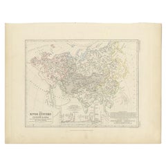

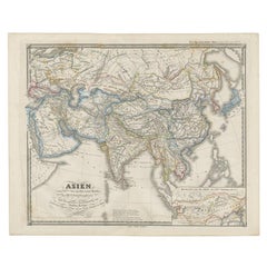
Antique Map of the River Systems of Europe and Asia by Johnston, c.1850
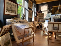
Located in Langweer, NL
We offer a wide range of authentic antique maps for any budget.
Category
19th Century Authentic Antique Maps
Materials
Paper
Antique Map of the River Systems of Europe and Asia by Johnston, c.1850
Located in Langweer, NL
We offer a wide range of authentic antique maps for any budget.
Paper


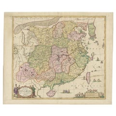
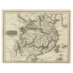
Antique Map of China, Also Depicting Formosa 'Taiwan' and Part of Korea, c.1840
Located in Langweer, NL
We offer a wide range of authentic antique maps for any budget.
Paper
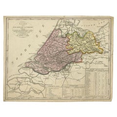

Antique Map of the Province of Zuid-Holland and Utrecht by Veelwaard, c.1840
Located in Langweer, NL
We offer a wide range of authentic antique maps for any budget.
Paper
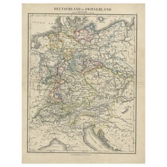

Antique Map of Germany and Switzerland from an Old Dutch School Atlas, c.1873
Located in Langweer, NL
We offer a wide range of authentic antique maps for any budget.
Paper
Detailed Map of New Zealand Showing the Route of Capt. Cook's First Voyage, 1803
Located in Langweer, NL
We offer a wide range of authentic antique maps for any budget.
Paper

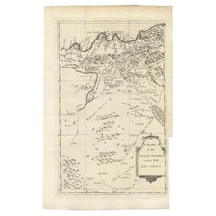
Detailed Original Old Map of the Southern Region of the Kingdom of Algiers 1773
Located in Langweer, NL
We offer a wide range of authentic antique maps for any budget.
Paper
Antique Map of the Lower Alsace Region of France by Mapmaker Hondius, c.1630
Located in Langweer, NL
We offer a wide range of authentic antique maps for any budget
Paper

$335Sale Price|20% Off
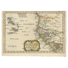
Antique Map of the West African Coast and the Cape Verde Islands, c.1680
Located in Langweer, NL
We offer a wide range of authentic antique maps for any budget.
Paper
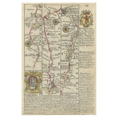
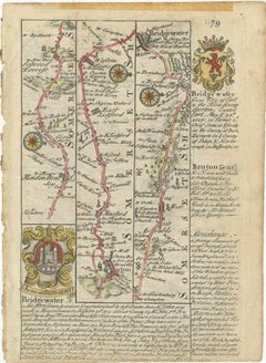
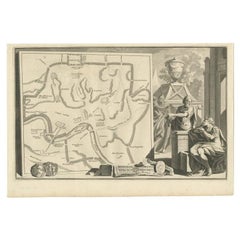
Rare Antique Map of the Route from Maiden Bridge to Dulverton, England, c.1720
By Bowen
Located in Langweer, NL
We offer a wide range of authentic antique maps for any budget.
Paper
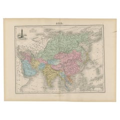

Antique Map of Asia with an Illustration of the Porcelain Tower at Nanjing, 1880
Located in Langweer, NL
We offer a wide range of authentic antique maps for any budget.
Paper
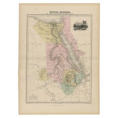

Antique Map of The Nile, Egypt, Nubia and Abyssinia and Inset of Jerusalem, 1880
Located in Langweer, NL
We offer a wide range of authentic antique maps for any budget.
Paper

Old Map of Ancient Rome Illustrating Major Monuments and the Seven Hills, c.1704
Located in Langweer, NL
We offer a wide range of authentic antique maps for any budget.
Paper


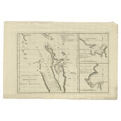
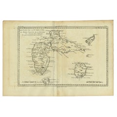
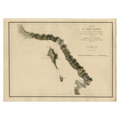
Antique Map of a Bay on the Coast of Chile, South America, c.1749
Located in Langweer, NL
We offer a wide range of authentic antique maps for any budget.
Paper
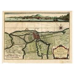

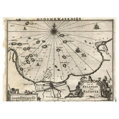
Antique Map of Batavia, Capital of The Dutch East Indies at the Time, 1751
Located in Langweer, NL
We offer a wide range of authentic antique maps for any budget.
Paper
$251Sale Price|20% Off
Antique Map of the Djati 'teak wood' Forest Near Rembang, Java by Stemler, 1875
By Stemler
Located in Langweer, NL
We offer a wide range of authentic antique maps for any budget.
Paper

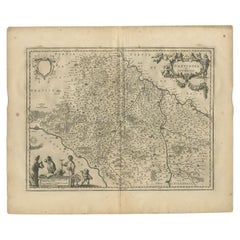
Antique Map of the Region Between the Rhine and Elbe River by Cluver, 1685
Located in Langweer, NL
We offer a wide range of authentic antique maps for any budget.
Paper

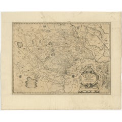
Antique Map of the Provinces of Madrid, Toledo and La Mancha by Homann, 1781
Located in Langweer, NL
We offer a wide range of authentic antique maps for any budget.
Paper

Antique Map of The Netherlands in The The Saxons and The Franks Period, 1718
Located in Langweer, NL
We offer a wide range of authentic antique maps for any budget.
Paper

Antique Map of China and Korea incl Formosa and Hainan, by Janssonius, ca.1650
Located in Langweer, NL
We offer a wide range of authentic antique maps for any budget.
Paper
Antique Map of Abyssinia, Sudan and the Red Sea, Arabia and Egypt South, 1749
Located in Langweer, NL
We offer a wide range of authentic antique maps for any budget.
Paper

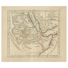
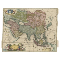
Antique Map of Asia from the Middle East to the Coast of Alaska, 1816
Located in Langweer, NL
We offer a wide range of authentic antique maps for any budget.
Paper

Antique Map of Eastern Seram, Part of the Maluku Island in East Indonesia, 1726
Located in Langweer, NL
We offer a wide range of authentic antique maps for any budget.
Paper
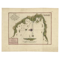

Chile Coast Bay Map – Antique 1749 Chart by Anson from Voyage Around the World
Located in Langweer, NL
We offer a wide range of authentic antique maps for any budget.
Paper

Antique Map of the Region Between the Seine and Loire Rivers by Janssonius, 1657
Located in Langweer, NL
We offer a wide range of authentic antique maps for any budget.
Paper

$537Sale Price|40% Off
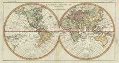
Very Decorative Original Antique Map of the World, Published in France in c.1780
By Rigobert Bonne
Located in Langweer, NL
We offer a wide range of authentic antique maps for any budget.
Paper
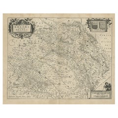

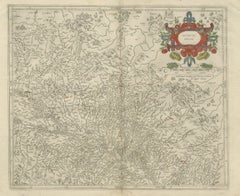
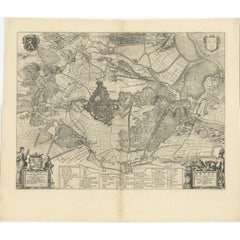
Antique Map of the Rethelois or Rethel Region in France by Janssonius, ca.1650
By Johannes Janssonius
Located in Langweer, NL
We offer a wide range of authentic antique maps for any budget.
Paper
$2,328Sale Price|20% Off
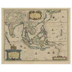
Original Antique Hand-Colored Map of The East Indies and Southeast Asia, c.1644
Located in Langweer, NL
This map is considered a must for all collectors of authentic and decorative maps of Indonesia or South East Asia in general.
Paper
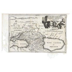

Antique Map of the Region Between the Black and Caspian Sea by Cellarius, 1731
Located in Langweer, NL
We offer a wide range of authentic antique maps for any budget.
Paper

Antique Hand-Coloured Map of Cities in the Province of Shanxi in China, 1749
Located in Langweer, NL
We offer a wide range of authentic antique maps for any budget.
Paper
Antique Map of the Siege of Breda, City in the Netherlands by Blaeu, 1649
Located in Langweer, NL
We offer a wide range of authentic antique maps for any budget.
Paper

$241Sale Price|20% Off
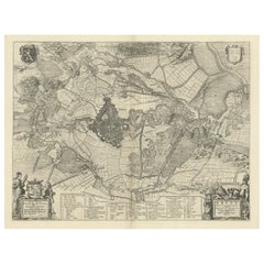
Antique Map of the Dutch Province of Gelderland with Zutphen as Capital, C.1650
Located in Langweer, NL
We offer a wide range of authentic antique maps for any budget.
Paper

$627Sale Price|30% Off
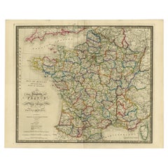
Antique Map of France according to the Treaty of Paris '1815', Published in 1854
Located in Langweer, NL
We offer a wide range of authentic antique maps for any budget.
Paper


Antique Map of Greece, Albania, Macedonia and Parts of Turkey and Cyprus, c.1745
Located in Langweer, NL
We offer a wide range of authentic antique maps for any budget.
Paper

Antique Map of the Islands Near Batavia, Capital of the Dutch East Indies, 1682
Located in Langweer, NL
We offer a wide range of authentic antique maps for any budget.
Paper

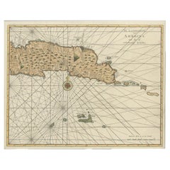
Antique Map of Guadeloupe with Les Saintes, Grand Bourg and La Désirade, c.1780
Located in Langweer, NL
We offer a wide range of authentic antique maps for any budget.
Paper
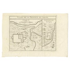

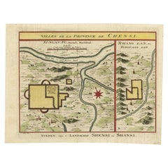
Antique Map of Two Cities in the Province of Shanxi or Chensi, China, 1748
By Jacques-Nicolas Bellin
Located in Langweer, NL
We offer a wide range of authentic antique maps for any budget.
Paper
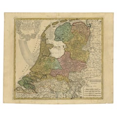

Detailed Old Map of the Seven Provinces of the Belgian/Dutch Federation, ca.1748
Located in Langweer, NL
We offer a wide range of authentic antique maps for any budget.
Paper

$167Sale Price|20% Off
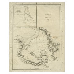
Old Map of Awatska Bay on the Coast of Kamchatka Peninsula, Russia by Cook, 1784
Located in Langweer, NL
We offer a wide range of authentic antique maps for any budget.
Paper
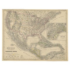

Old German Map of the United States, Central America and the West Indies, c.1870
Located in Langweer, NL
We offer a wide range of authentic antique maps for any budget.
Paper
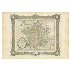

Antique Map of France under the Reign of Henry and Francois II by Zannoni, 1765
Located in Langweer, NL
We offer a wide range of authentic antique maps for any budget.
Paper
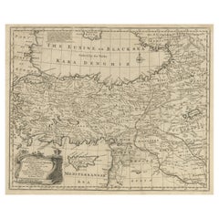

Antique Map of Asia Minor with Cyprus, Syria and Turkey and the Black Sea, 1747
Located in Langweer, NL
We offer a wide range of authentic antique maps for any budget.
Paper

Antique Map of the South-Western Coast of Sumatra by De la Haye, c.1780
Located in Langweer, NL
We offer a wide range of authentic antique maps for any budget.
Paper

$204Sale Price|20% Off
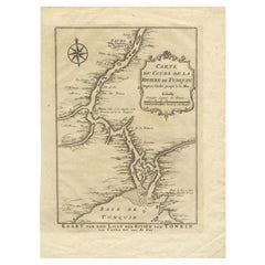
Antique Map of the Tunquin River and Bay to Cacho, the Capital City, Siam, 1758
Located in Langweer, NL
We offer a wide range of authentic antique maps for any budget.
Paper

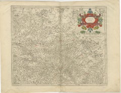
Antique Map of the Region of Sedan and Doncheri in France by Janssonius, c.1650
By Johannes Janssonius
Located in Langweer, NL
We offer a wide range of authentic antique maps for any budget.
Paper

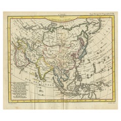
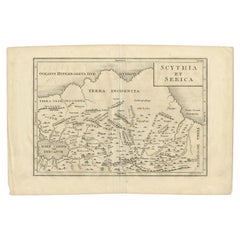
Old Map of Asia Depicting Asia in the 6th through the 9th Centuries, ca. 1855
Located in Langweer, NL
We offer a wide range of authentic antique maps for any budget.
Paper

Antique Map of Artois in the North of France by Famous Mapmaker Blaeu, c.1640
Located in Langweer, NL
We offer a wide range of authentic antique maps for any budget.
Paper
$2,328Sale Price|20% Off
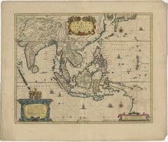
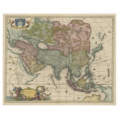
Antique Map of Asia and the East Indies and Korea as a Peninsula, ca.1660
Located in Langweer, NL
We offer a wide range of authentic antique maps for any budget.
Paper


Antique Map of the Rhine and Moselle River Region in Germany and France, c.1680
Located in Langweer, NL
We offer a wide range of authentic antique maps for any budget.
Paper

Antique Map of the Coast of New Ireland, Earlier Part of German New Guinea, 1833
Located in Langweer, NL
We offer a wide range of authentic antique maps for any budget.
Paper

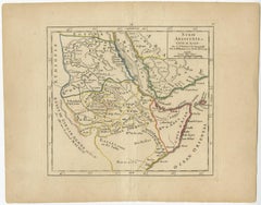
Antique Map of the Region Between the Caspian and the Sea of China by Toms, 1799
Located in Langweer, NL
We offer a wide range of authentic antique maps for any budget.
Paper
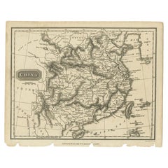
Old Map of the Mainland of China and the Islands of Formosa or Taiwan, c.1817
Located in Langweer, NL
We offer a wide range of authentic antique maps for any budget.
Paper
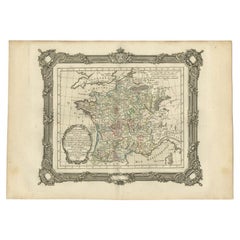
Antique Map of France at the End of the Reign of Jean II by Zannoni, 1765
By G. A. Rizzi-zannoni
Located in Langweer, NL
We offer a wide range of authentic antique maps for any budget.
Paper
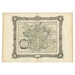

Antique Map of France at the end of the Reign of Louis the Great by Zannoni 1765
By G. A. Rizzi-zannoni
Located in Langweer, NL
We offer a wide range of authentic antique maps for any budget.
Paper
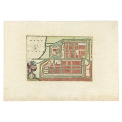

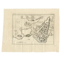
Antique Plan of Batavia in the Dutch East Indies or Nowadays Jakarta, Indonesia
Located in Langweer, NL
We offer a wide range of authentic antique maps for any budget.
Paper
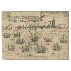

Antique Plan of Duinkerke or Dunkirk in France by Guicciardini, 1612
Located in Langweer, NL
We offer a wide range of authentic antique maps for any budget.
Paper
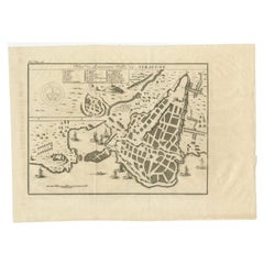
Antique Plan of Ancient Syracuse, Plan of ancient Syracuse, Sicily, Italy
Located in Langweer, NL
We offer a wide range of authentic antique maps for any budget.
Paper

Antique Plan of Ancient Syracuse, cicily, Italy, 1740
Located in Langweer, NL
We offer a wide range of authentic antique maps for any budget.
Paper