Items Similar to Antique Map of the Dutch Province of Gelderland with Zutphen as Capital, C.1650
Want more images or videos?
Request additional images or videos from the seller
1 of 6
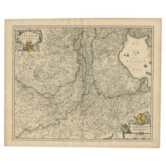
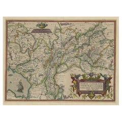
Antique Map of the Dutch Province of Gelderland with Zutphen as Capital, C.1650
About the Item
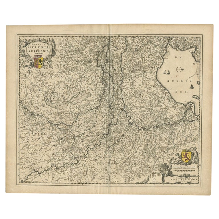
Antique map titled 'Ducatus Gelriae pars Tertia quae est comitatus Zutphaniensis'. Old map of the province of Gelderland, the Netherlands. The city of Zutphen can be found in the middle of the map. Artists and Engravers: Johannes Janssonius also known as Jan Jansson (1588-1664) was born in Arnhem, Netherlands. His father was a bookseller and publisher (Jan Janszoon the Elder). When he married the daughter of the cartographer Jodocus Hondius he also set up a business as book publisher in Amsterdam. His first map was published in 1616. Around 15 years later he set up a partnership with his brother in law Hondius add issued further editions of the Mercator/Hondius atlas. After his death his heirs still have published several maps. Many of his plates have been acquired by Pieter Schenk and Gerard Valk.
Artist: Johannes Janssonius also known as Jan Jansson (1588-1664) was born in Arnhem, Netherlands. His father was a bookseller and publisher (Jan Janszoon the Elder). When he married the daughter of the cartographer Jodocus Hondius he also set up a business as book publisher in Amsterdam. His first map was published in 1616. Around 15 years later he set up a partnership with his brother in law Hondius add issued further editions of the Mercator/Hondius atlas. After his death his heirs still have published several maps. Many of his plates have been acquired by Pieter Schenk and Gerard Valk.
Condition: Fair, general age-related toning and some staining. Trimmed to plate mark, mounted and margins extended. Please study image carefully.
Date: c.1650
Overall size: 63 x 52 cm.
Image size: 52 x 38 cm.
We sell original antique maps to collectors, historians, educators and interior decorators all over the world. Our collection includes a wide range of authentic antique maps from the 16th to the 20th centuries. Buying and collecting antique maps is a tradition that goes back hundreds of years. Antique maps have proved a richly rewarding investment over the past decade, thanks to a growing appreciation of their unique historical appeal. Today the decorative qualities of antique maps are widely recognized by interior designers who appreciate their beauty and design flexibility. Depending on the individual map, presentation, and context, a rare or antique map can be modern, traditional, abstract, figurative, serious or whimsical. We offer a wide range of authentic antique maps for any budget.
- Dimensions:Height: 20.48 in (52 cm)Width: 24.81 in (63 cm)Depth: 0 in (0.01 mm)
- Materials and Techniques:
- Period:
- Date of Manufacture:circa 1650
- Condition:Condition: Fair, general age-related toning and some staining. Trimmed to plate mark, mounted and margins extended. Please study image carefully.
- Seller Location:Langweer, NL
- Reference Number:
About the Seller
5.0
Platinum Seller
These expertly vetted sellers are 1stDibs' most experienced sellers and are rated highest by our customers.
Established in 2009
1stDibs seller since 2017
1,940 sales on 1stDibs
Typical response time: <1 hour
- ShippingRetrieving quote...Ships From: Langweer, Netherlands
- Return PolicyA return for this item may be initiated within 14 days of delivery.
More From This SellerView All
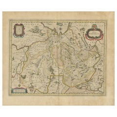
- Antique Map of the Dutch Province of Gelderland by Visscher, c.1670Located in Langweer, NLAntique map titled 'Ducatus Geldria et Zutphania Comitatus'. Map of the Duchy of Gelre (Gelderland) and the county of Zutphen, The Netherlands. Artists and Engravers: Made after the ...Category
Antique 17th Century Maps
MaterialsPaper
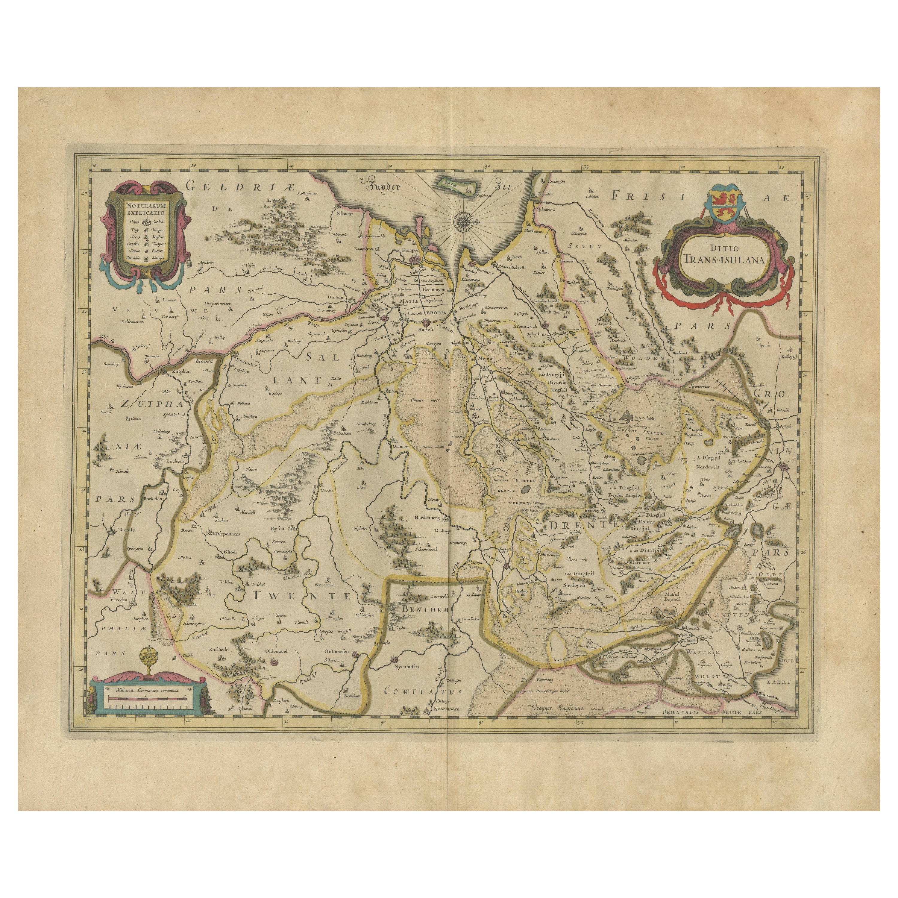
- Antique Map by Janssonius of the Dutch Province of Overijsel, ca.1650Located in Langweer, NLVery good, given the age. Center fold as issued with wide margins. Sharp print with beautiful old-fashioned colouring, carbon copy on verso. Paper in the margins somewhat browned.Category
Antique 1650s Maps
MaterialsPaper
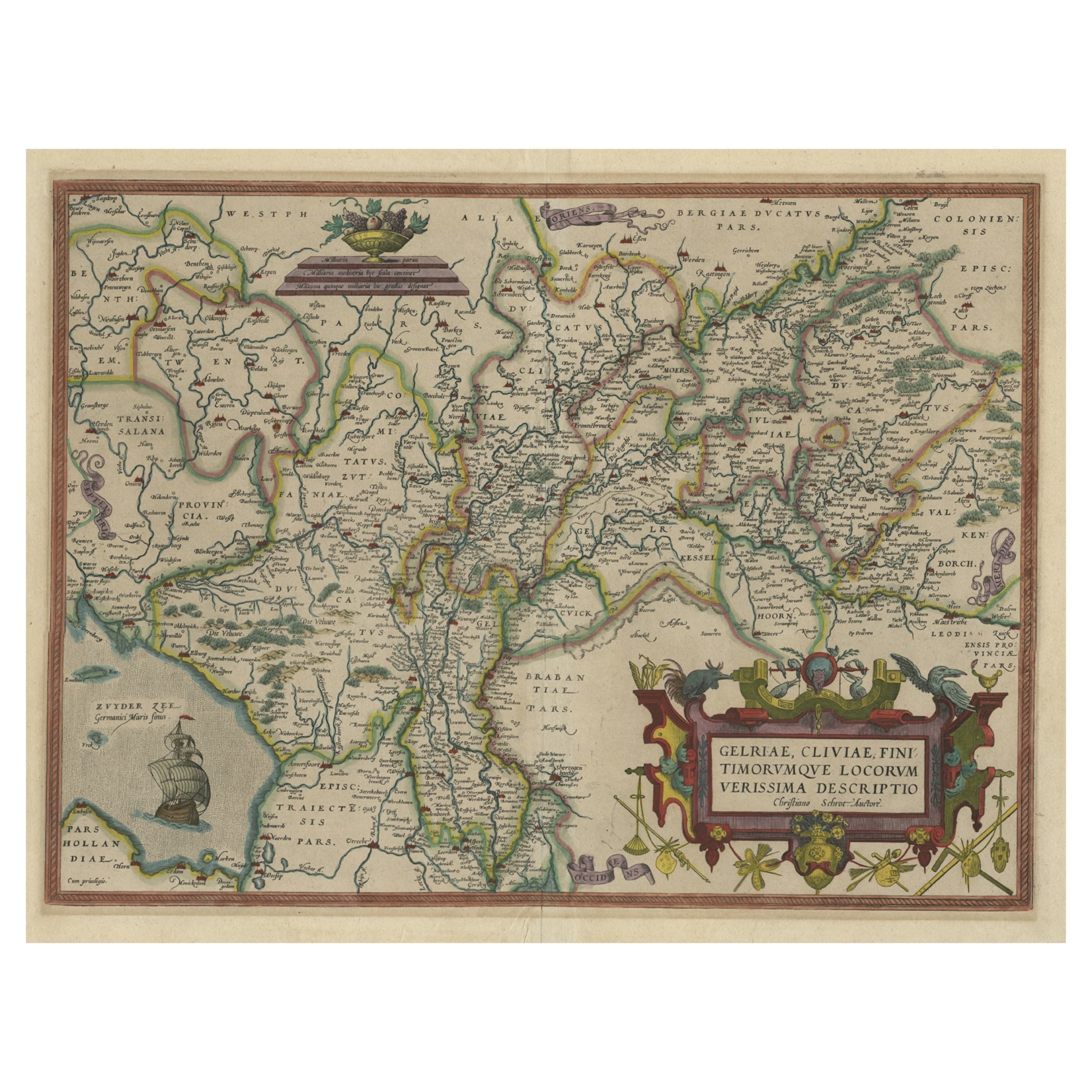
- Superb Antique Map of the Province of Gelderland, the Netherlands, ca.1575Located in Langweer, NLAntique map titled 'Gelriae, Cliviae, Finitimorumque Locorum Verissima Descriptio Christiano Schrot. Auctore'. This superb map is Ortelius' first plate covering Gelderland. It is...Category
Antique 16th Century Maps
MaterialsPaper
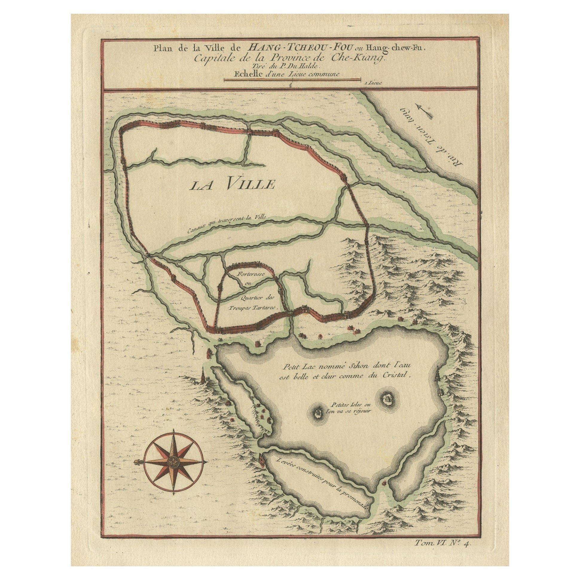
- Antique Map of Hangzhou, Capital of the Province of Zheijang, China, c.1750Located in Langweer, NLAntique map titled ‘Plan de la ville de Hang-Tcheou-Fou ou Hang-Chew-Fu Capitale de la Province de Che-Kiang’. This original print shows a map of the city of Hangzhou, capital of the...Category
Antique 1750s Maps
MaterialsPaper
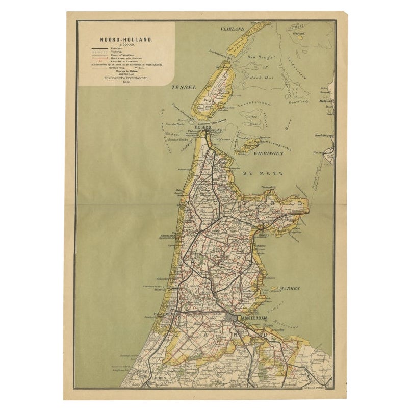
- Antique Map of Noord-Holland, Province of The Netherlands, 1902Located in Langweer, NLAntique map titled 'Noord-Holland'. Lithographed map of the province of Noord-Holland, the Netherlands. This map originates from 'Atlas van Nederland'. Artists and Engravers: Publish...Category
20th Century Maps
MaterialsPaper
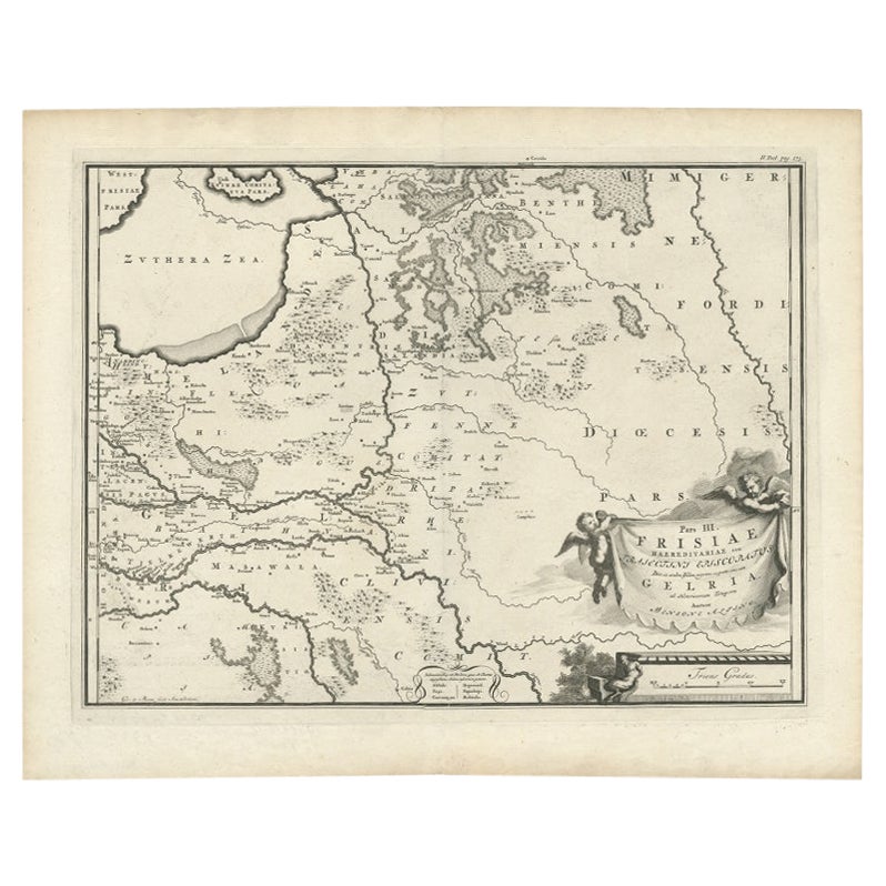
- Antique Map of the Dutch Province of Gelderland, 1725Located in Langweer, NLAntique map titled 'Frisiae Haereditariae seu Trajectini Episcopatus Gelria?. Map of the province of Gelderland, the Netherlands. This map originates from 'Atlas Descriptio, secundum...Category
Antique 18th Century Maps
MaterialsPaper
You May Also Like
- Antique 18th Century Map of the Province of Pensilvania 'Pennsylvania State'Located in Philadelphia, PAA fine antique of the colony of Pennsylvania. Noted at the top of the sheet as a 'Map of the province of Pensilvania'. This undated and anonymous map is thought to be from the Gentleman's Magazine, London, circa 1775, although the general appearance could date it to the 1760's. The southern boundary reflects the Mason-Dixon survey (1768), the western boundary is placed just west of Pittsburgh, and the northern boundary is not marked. The map has a number of reference points that likely refer to companion text and appear to be connected to boundaries. The western and southern boundaries are marked Q, R, S, for example. A diagonal line runs from the Susquehanna R to the Lake Erie P. A broken line marked by many letters A, B, N, O, etc., appears in the east. There are no latitude or longitude markings, blank verso. Framed in a shaped contemporary gilt wooden frame and matted under a cream colored matte. Bearing an old Graham Arader Gallery...Category
Antique 18th Century British American Colonial Maps
MaterialsPaper
- The Holy Land at the Time of Jesus: A 17th Century Dutch Map by VisscherBy Nicolaes Visscher IILocated in Alamo, CAThis detailed Dutch map entitled "Het Beloofe de Landt Canaan door wandelt van onsen Salichmaecker Iesu Christo, nessens syne Apostelen" by Nicolaes Visscher was published in Amsterd...Category
Antique Mid-17th Century Dutch Maps
MaterialsPaper
- Map of the Republic of GenoaLocated in New York, NYFramed antique hand-coloured map of the Republic of Genoa including the duchies of Mantua, Modena, and Parma. Europe, late 18th century. Dimension: 25...Category
Antique Late 18th Century European Maps
- Antique Map of Principality of MonacoBy Antonio Vallardi EditoreLocated in Alessandria, PiemonteST/619 - "Old Geographical Atlas of Italy - Topographic map of ex-Principality of Monaco" - ediz Vallardi - Milano - A somewhat special edition ---Category
Antique Late 19th Century Italian Other Prints
MaterialsPaper
- Original Antique Map of The World by Thomas Clerk, 1817Located in St Annes, LancashireGreat map of The Eastern and Western Hemispheres On 2 sheets Copper-plate engraving Drawn and engraved by Thomas Clerk, Edinburgh. Published by Mackenzie And Dent, 1817 ...Category
Antique 1810s English Maps
MaterialsPaper
- Map "Estuary- Mouth of the Thames"Located in Alessandria, PiemonteST/426 - Antique French Map of the estuary of the Thames, map dated 1769 - "Mape of the entrance of the Thames. Designed by filing of Navy cards fo...Category
Antique Mid-18th Century French Other Prints
MaterialsPaper


Recently Viewed
View AllMore Ways To Browse
Antique Capital
Antique 17th Century Dutch
Dutch 16th Century Furniture
Set Of Maps
Jan Book
Dutch Plate Set
Dutch 1650
17th Century Plate Set
Antique Province Map
Map Of Antique Province
Antique Province Map Of Antique
Mercator Antique
Antique Map Set
Set Of Antique Maps
Antique Map Schenk
Netherlands 16th Century
Antique Furniture In Texas
Antique Map Of England