Items Similar to Antique Map of the Provinces of Madrid, Toledo and La Mancha by Homann, 1781

Want more images or videos?
Request additional images or videos from the seller
1 of 6
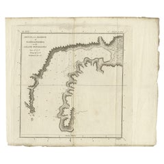
Antique Map of the Provinces of Madrid, Toledo and La Mancha by Homann, 1781
About the Item
Antique map titled 'Castilliae Novae pars Occidentalis provincias Madrit, Toledo et Mancha (..)'. Antique map of the central Spanish provinces of Madrid, Toledo and La Mancha with pictorial cartouche and scale of miles.
Artists and Engravers: Homann Heirs was a German publishing firm that enjoyed a major place in the European map market throughout the eighteenth century. Founded in 1702 by Johann Baptist Homann, the business passed to his son, Christoph, upon Johann’s death in 1724. Christoph died in 1730, aged only 27, and the firm was inherited by subsequent Homann heirs. This altered the name of the company, which was known as Homann Erben, or Homann heirs. The firm continued in business until 1848.
Condition: Very good, general age-related toning. Please study image carefully.
Date: 1781
Overall size: 52.5 x 62 cm.
Image size: 45 x 49.5 cm.
We sell original antique maps to collectors, historians, educators and interior decorators all over the world. Our collection includes a wide range of authentic antique maps from the 16th to the 20th centuries. Buying and collecting antique maps is a tradition that goes back hundreds of years. Antique maps have proved a richly rewarding investment over the past decade, thanks to a growing appreciation of their unique historical appeal. Today the decorative qualities of antique maps are widely recognized by interior designers who appreciate their beauty and design flexibility. Depending on the individual map, presentation, and context, a rare or antique map can be modern, traditional, abstract, figurative, serious or whimsical. We offer a wide range of authentic antique maps for any budget.
- Dimensions:Height: 24.41 in (62 cm)Width: 20.67 in (52.5 cm)Depth: 0 in (0.01 mm)
- Materials and Techniques:
- Period:
- Date of Manufacture:1781
- Condition:
- Seller Location:Langweer, NL
- Reference Number:
About the Seller
5.0
Platinum Seller
These expertly vetted sellers are 1stDibs' most experienced sellers and are rated highest by our customers.
Established in 2009
1stDibs seller since 2017
1,932 sales on 1stDibs
Typical response time: <1 hour
- ShippingRetrieving quote...Ships From: Langweer, Netherlands
- Return PolicyA return for this item may be initiated within 14 days of delivery.
More From This SellerView All
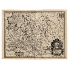
- Antique Map of the Seventeen Provinces by Homann Heirs, 1748By Homann HeirsLocated in Langweer, NLAntique map titled 'Belgii Universi seu Inferioris Germaniae quam XVII Provinciae (..)'. Map of the Seventeen Provinces after Tobias Meier, published by Homann's Heirs in 1748. The S...Category
Antique 18th Century Maps
MaterialsPaper
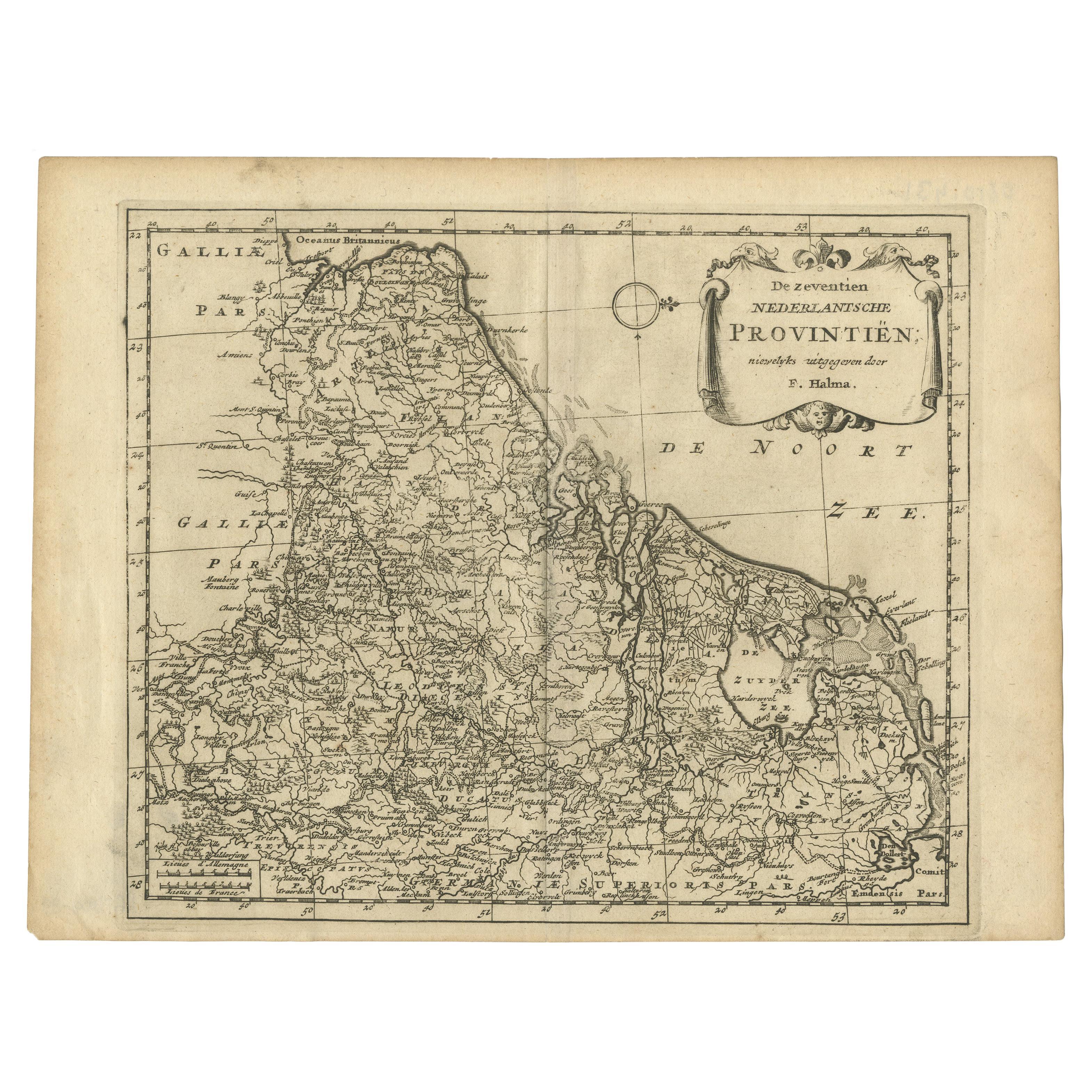
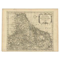
- Antique Map of the Seventeen Provinces by Halma '1705'Located in Langweer, NLAntique map titled 'De zeventien Nederlantsche Provintiën'. Original antique map of the Seventeen Provinces, the Imperial states of the Habsburg Netherlands in the 16th century. This...Category
Antique Early 18th Century Maps
MaterialsPaper
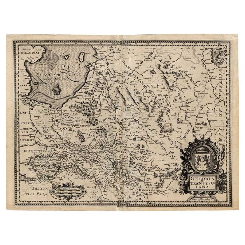
- Antique Map of the Provinces of Gelderland and Overijssel by Kaerius, 1617Located in Langweer, NLAntique map titled 'Geldria et Transysulana'. Scarse map by Kaerius of the provinces Gelderland and Overijssel in the Netherlands. Large cartouche with coat of arms and sailing ship ...Category
Antique 17th Century Maps
MaterialsPaper
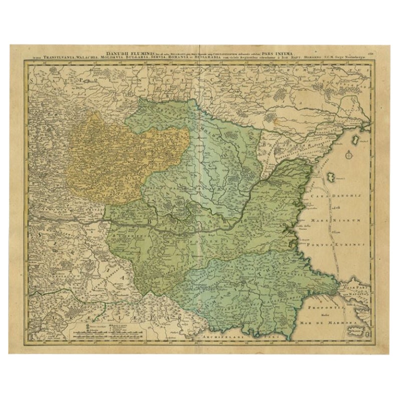
- Antique Map of the Danube River by Homann, c.1720By Homann HeirsLocated in Langweer, NLAntique map titled 'Danubii Fluminis (..)'. Regional map of the Donau river, Shows the Danube river from Belgrade in Serbia, along the border between Roma...Category
Antique 18th Century Maps
MaterialsPaper
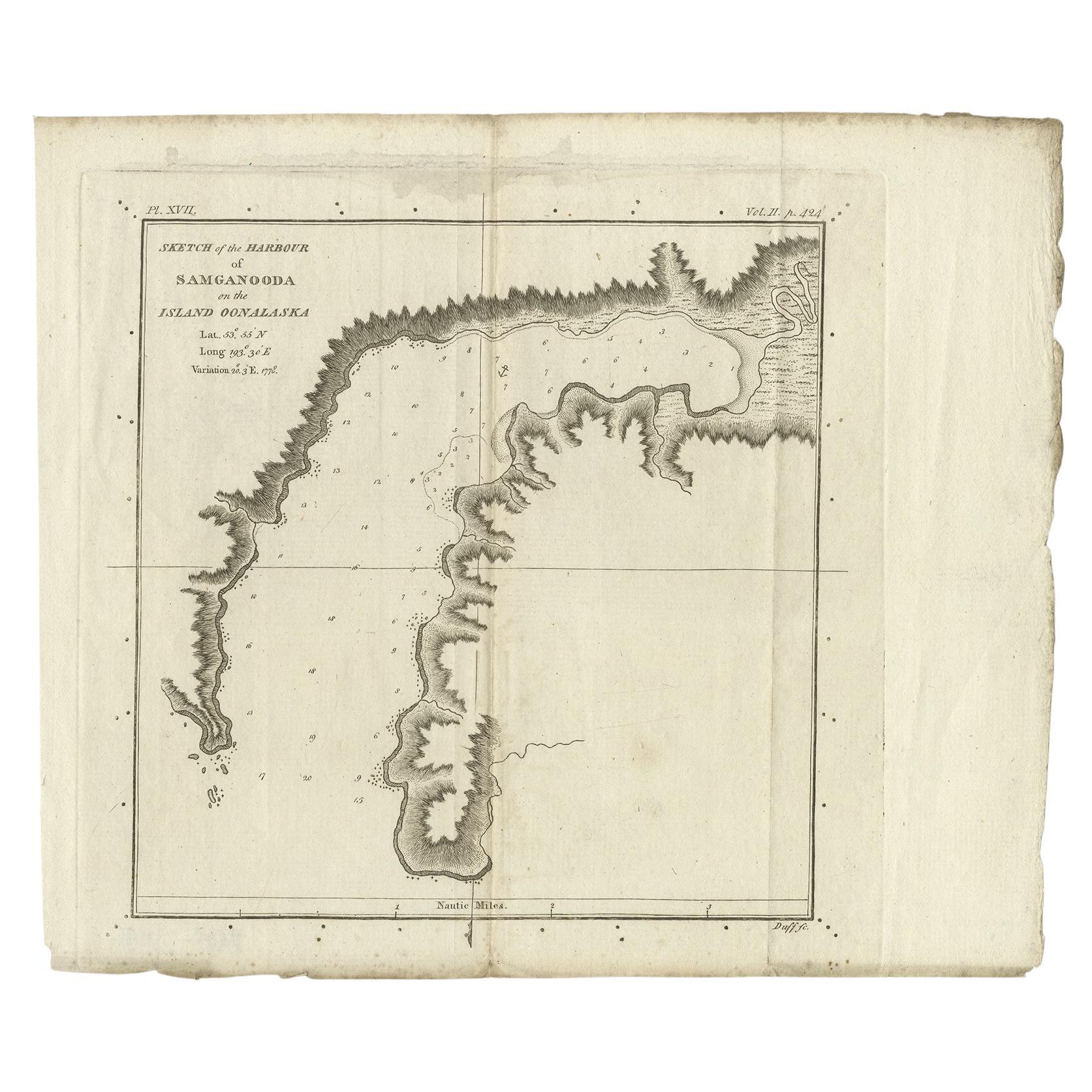
- Antique Map of the Harbour of Samganoodha by Cook, c.1781Located in Langweer, NLAntique map titled 'Sketch of the Harbour of Samganooda (..)'. Antique map of the Harbour of Samganoodha, Oonalaska, North America. Originates from an edition of Cook's Voyages. A...Category
Antique 18th Century Maps
MaterialsPaper
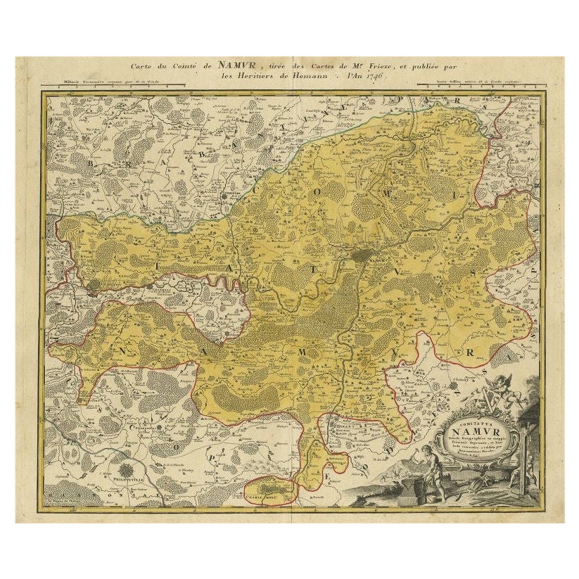
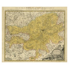
- Antique Map of the Region of Namen by Homann, 1746By Johann Baptist HomannLocated in Langweer, NLAntique map titled 'Comitatus Namur Tabula Geographica ex mappis Frixianis'. Regional map of Namen, Belgium. Artists and Engravers: Homann Heirs was a German publishing firm tha...Category
Antique 18th Century Maps
MaterialsPaper

You May Also Like
- The Kingdom of Naples and Southern Italy: A Hand-Colored 18th Century Homann MapBy Johann Baptist HomannLocated in Alamo, CA"Novissima & exactissimus Totius Regni Neapolis Tabula Presentis Belli Satui Accommo Data" is a hand colored map of southern Italy and the ancient Kingdom of Naples created by Johann...Category
Antique Early 18th Century German Maps
MaterialsPaper
- Hand Colored 18th Century Homann Map of Austria Including Vienna and the DanubeBy Johann Baptist HomannLocated in Alamo, CA"Archiducatus Austriae inferioris" is a hand colored map of Austria created by Johann Baptist Homann (1663-1724) and published in Nuremberg, Germany in 1728 shortly after his death. ...Category
Antique Early 18th Century German Maps
MaterialsPaper
- Hand-Colored 18th Century Homann Map of the Black Sea, Turkey and Asia MinorBy Johann Baptist HomannLocated in Alamo, CAAn attractive original early 18th century hand-colored map of the Black Sea and Turkey entitled "Carte de L'Asie Minevre ou de la Natolie et du Pont Evxin Tiree des Voyages et des Ob...Category
Antique Early 18th Century German Maps
MaterialsPaper
- Hand-Colored 18th Century Homann Map of Denmark and Islands in the Baltic SeaBy Johann Baptist HomannLocated in Alamo, CAAn 18th century copper plate hand-colored map entitled "Insulae Danicae in Mari Balthico Sitae utpote Zeelandia, Fionia, Langelandia, Lalandia, Falstria, Fembria Mona" created by Joh...Category
Antique Early 18th Century German Maps
MaterialsPaper
- Hand-Colored 18th Century Homann Map of the Danube, Italy, Greece, CroatiaBy Johann Baptist HomannLocated in Alamo, CA"Fluviorum in Europa principis Danubii" is a hand colored map of the region about the Danube river created by Johann Baptist Homann (1663-1724) in his 'Atlas Novus Terrarum', publish...Category
Antique Early 18th Century German Maps
MaterialsPaper
- Sweden & Adjacent Portions of Scandinavia: A Hand-Colored 18th C. Map by HomannBy Johann Baptist HomannLocated in Alamo, CAThis hand-colored map of Sweden and adjacent portions of Scandinavia entitled "Regni Sueciae in Omnes suas Subjacentes Provincias accurate divisi Tabula Generalis" was created by Joh...Category
Antique 1720s German Maps
MaterialsPaper


Recently Viewed
View AllMore Ways To Browse
Furniture In Madrid
La Place Antiques
Used Furniture Toledo
Antique Market Scale
Madrid Antique
Toledo Spanish
Toledo Spain
La Mancha
Madrid Map
Antique Toledo Scale Scales
Antique Toledo Scale
Toledo Scale Company Antique
Antique Architecture Plan
Seven Fold
Antique Map Series
Antique Street Maps
Scottish Fold
Antique Doctors Office Furniture