Items Similar to Detailed Old Map of the Seven Provinces of the Belgian/Dutch Federation, ca.1748

Want more images or videos?
Request additional images or videos from the seller
1 of 7
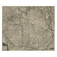
Detailed Old Map of the Seven Provinces of the Belgian/Dutch Federation, ca.1748
About the Item
Antique map titled 'Septem Provinciae seu Belgium Foederatum quod generliter Hollandia (..).' Detailed antique map of the seven provinces of the Belgian Federation (Dutch Federation), nowadays Holland / the Netherlands. The title cartouche in the upper left corner features the armorial coasts of the seven states: Gelderland, Holland, Zeeland, Utrecht, Friesland, Overijsel and Groningen. This map was drawn by Johann Tobias Mayer and published by Homann Heirs. Source unknown, to be determined. Artists and Engravers: Following the long period of Dutch domination, the Homann family became the most important map publishers in Germany in the eighteenth century, the business being founded by J.B. Homann in Nuremberg about the year 1702. Soon after publishing his first atlas in 1707 he became a member of the Berlin academy of Sciences and in 1715 he was appointed Geographer to the Emperor. After the founder's death in 1724, the firm was continued under the direction of his son until 1730 and was then bequeathed to his heirs on the condition that it trades under the name of Homann Heirs. The firm remained in being until the next century and had a wide influence on map publishing in Germany. Apart from the atlases the firm published a very large number of individual maps. The Homanns produced a Neuer Atlas in 1714, a Grosser Atlas in 1737, and an Atlas Maior with about 300 maps in 1780. They also issued a special Atlas of Germany with full sized plans of principal cities, school atlases and an Atlas of Silesia in 1750 with 20 maps.
Artist: Following the long period of Dutch domination, the Homann family became the most important map publishers in Germany in the eighteenth century, the business being founded by J.B. Homann in Nuremberg about the year 1702. Soon after publishing his first atlas in 1707 he became a member of the Berlin academy of Sciences and in 1715 he was appointed Geographer to the Emperor. After the founder's death in 1724, the firm was continued under the direction of his son until 1730 and was then bequeathed to his heirs on the condition that it trades under the name of Homann Heirs. The firm remained in being until the next century and had a wide influence on map publishing in Germany. Apart from the atlases the firm published a very large number of individual maps. The Homanns produced a Neuer Atlas in 1714, a Grosser Atlas in 1737, and an Atlas Maior with about 300 maps in 1780. They also issued a special Atlas of Germany with full sized plans of principal cities, school atlases and an Atlas of Silesia in 1750 with 20 maps.
Condition: Good, given age. Light staining and soiling in the margins. Tiny tear bottom right edge. A few small spots. Original middle fold as issued. General age-related toning and/or occasional minor defects from handling. Please study image carefully.
Date: c.1748
Overall size: 64 x 53.5 cm.
Image size: 0.001 x 51.7 x 47.5 cm.
We sell original antique maps to collectors, historians, educators and interior decorators all over the world. Our collection includes a wide range of authentic antique maps from the 16th to the 20th centuries. Buying and collecting antique maps is a tradition that goes back hundreds of years. Antique maps have proved a richly rewarding investment over the past decade, thanks to a growing appreciation of their unique historical appeal. Today the decorative qualities of antique maps are widely recognized by interior designers who appreciate their beauty and design flexibility. Depending on the individual map, presentation, and context, a rare or antique map can be modern, traditional, abstract, figurative, serious or whimsical. We offer a wide range of authentic antique maps for any budget.
- Dimensions:Height: 25.2 in (64 cm)Width: 21.07 in (53.5 cm)Depth: 0 in (0.01 mm)
- Materials and Techniques:
- Period:
- Date of Manufacture:circa 1748
- Condition:Condition: Good, given age. Light staining and soiling in the margins. Tiny tear bottom right edge. A few small spots. Original middle fold as issued. General age-related toning and/or occasional minor defects from handling. Please study image.
- Seller Location:Langweer, NL
- Reference Number:
About the Seller
5.0
Platinum Seller
These expertly vetted sellers are 1stDibs' most experienced sellers and are rated highest by our customers.
Established in 2009
1stDibs seller since 2017
1,929 sales on 1stDibs
Typical response time: <1 hour
- ShippingRetrieving quote...Ships From: Langweer, Netherlands
- Return PolicyA return for this item may be initiated within 14 days of delivery.
More From This SellerView All
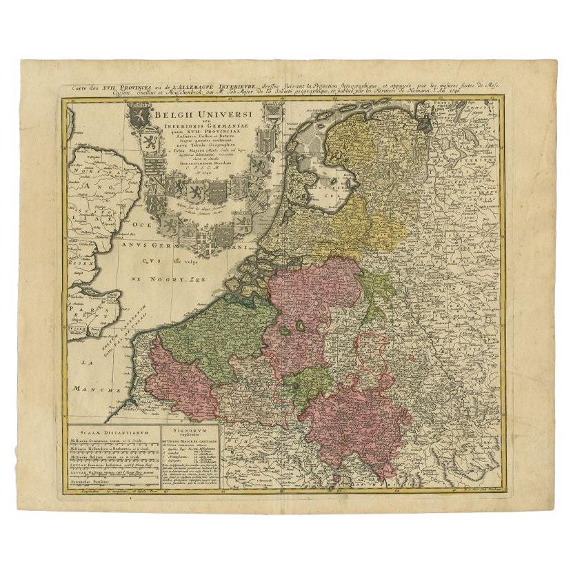
- Antique Map of the Seventeen Provinces of Netherlands, Belgium, Luxembourg, 1748By Homann HeirsLocated in Langweer, NLAntique map titled 'Belgii Universi seu Inferioris Germaniae quam XVII Provinciae (..)'. Map of the Seventeen Provinces after Tobias Meier, published by Homann's Heirs in 1748. The...Category
Antique 18th Century Maps
MaterialsPaper
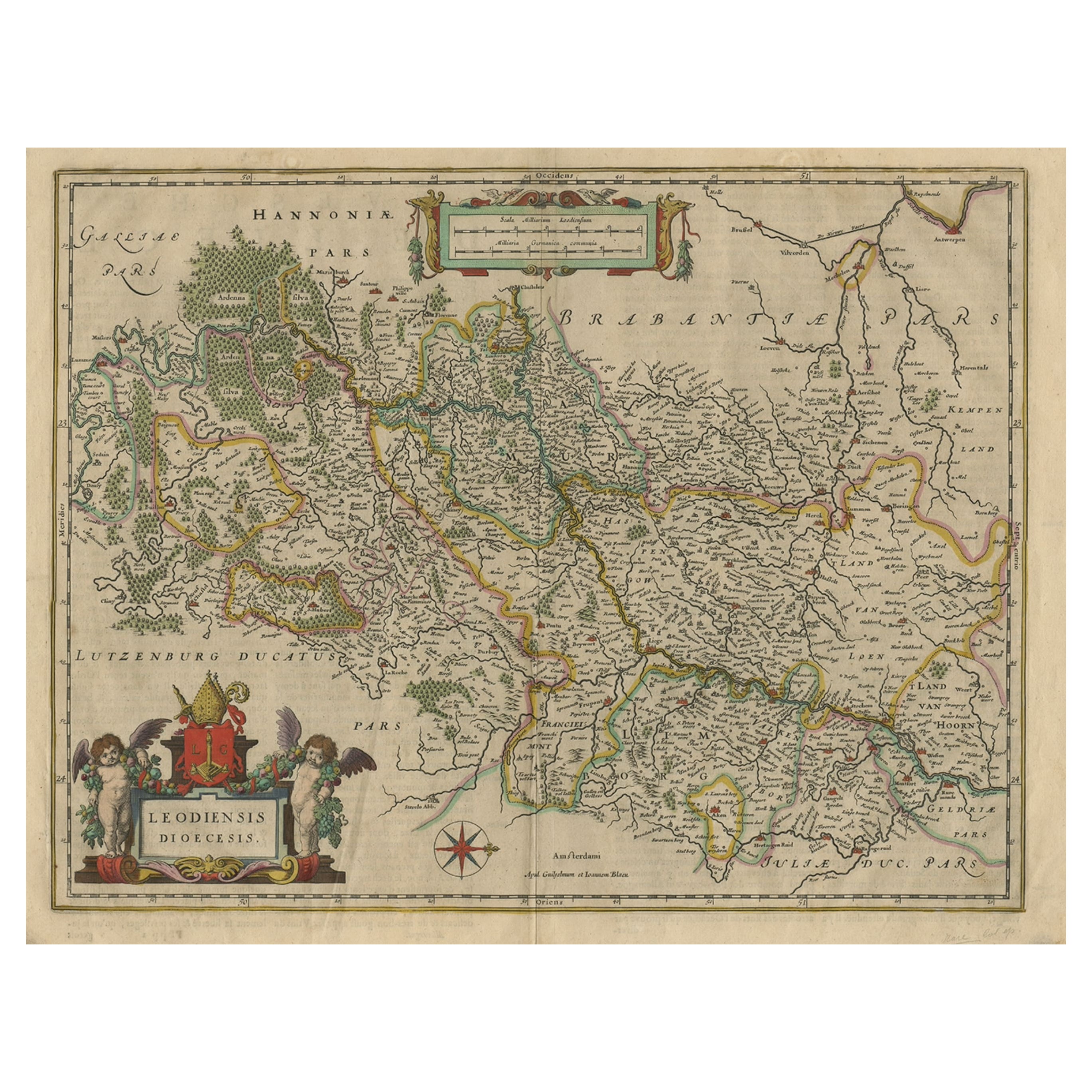
- Antique Map of Dutch & Belgium Provinces Limburg, Namen and Ardennes, ca.1635Located in Langweer, NLAntique print, titled: 'Leodiensis Dioecesis.' Detailed map including the Dutch and Belgium provinces Limburg and the Belgium province of Namen and Ardennes. Exquisitely engraved...Category
Antique 1630s Maps
MaterialsPaper
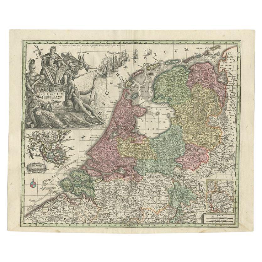
- Antique Map of the Seven United Provinces of Holland by Seutter, 1727Located in Langweer, NLAntique map titled ‘Belgium Foederatum Auctius Et Emendatius‘. Important antique map of the Seven United Provinces of Holland with inset views of the East Indies, the province of Lim...Category
Antique 18th Century Maps
MaterialsPaper
- Antique Map of the Seventeen Provinces by Homann Heirs, 1748By Homann HeirsLocated in Langweer, NLAntique map titled 'Belgii Universi seu Inferioris Germaniae quam XVII Provinciae (..)'. Map of the Seventeen Provinces after Tobias Meier, published by Homann's Heirs in 1748. The S...Category
Antique 18th Century Maps
MaterialsPaper
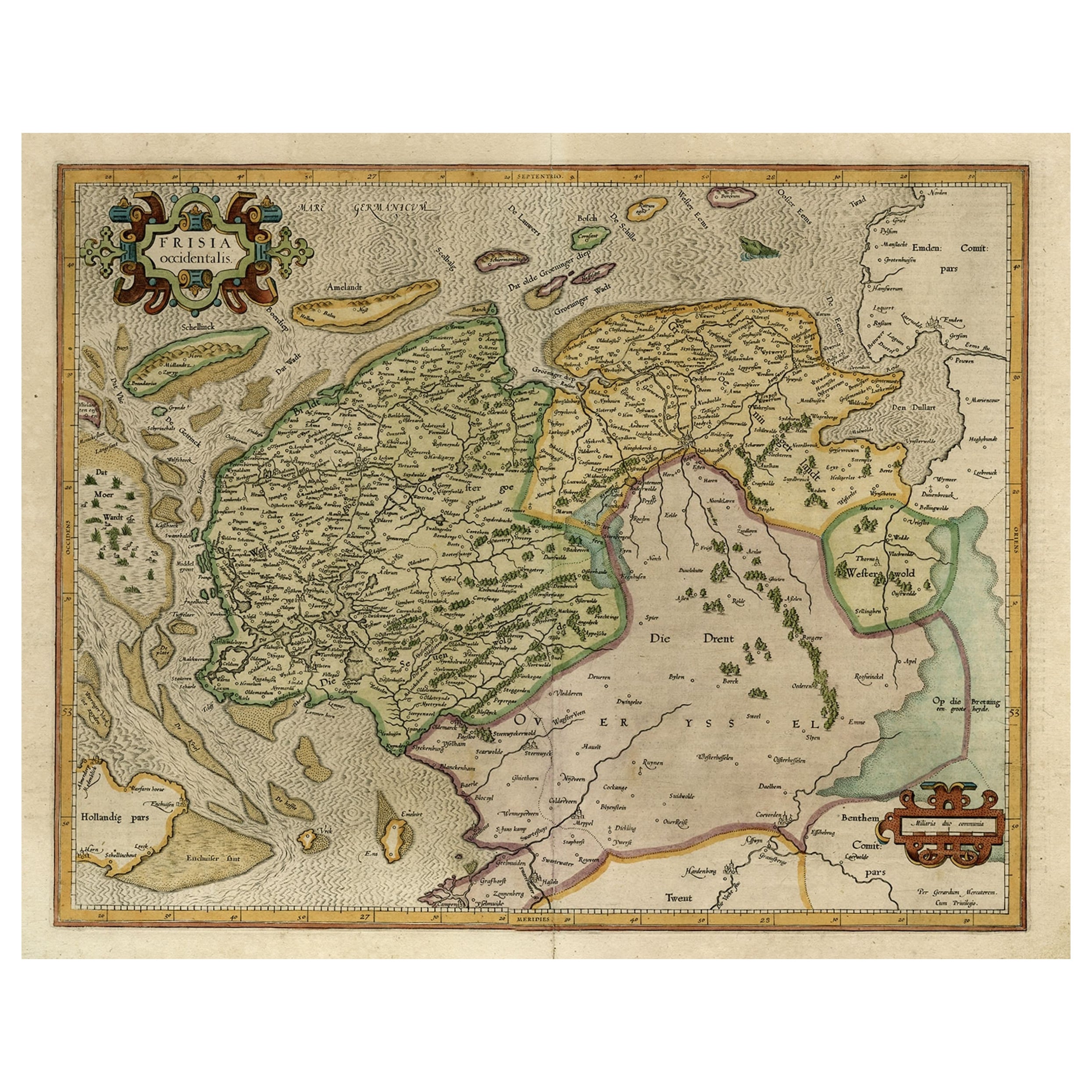
- Old Map of the Dutch Provinces of Friesland and Groningen, The Netherlands, 1604Located in Langweer, NLAntique print, titled: 'Frisiae Occidentalis.' Handsome map of the Dutch Provinces of Friesland and Groningen. Embellished with strapwork title-car...Category
Antique Early 1600s Maps
MaterialsPaper
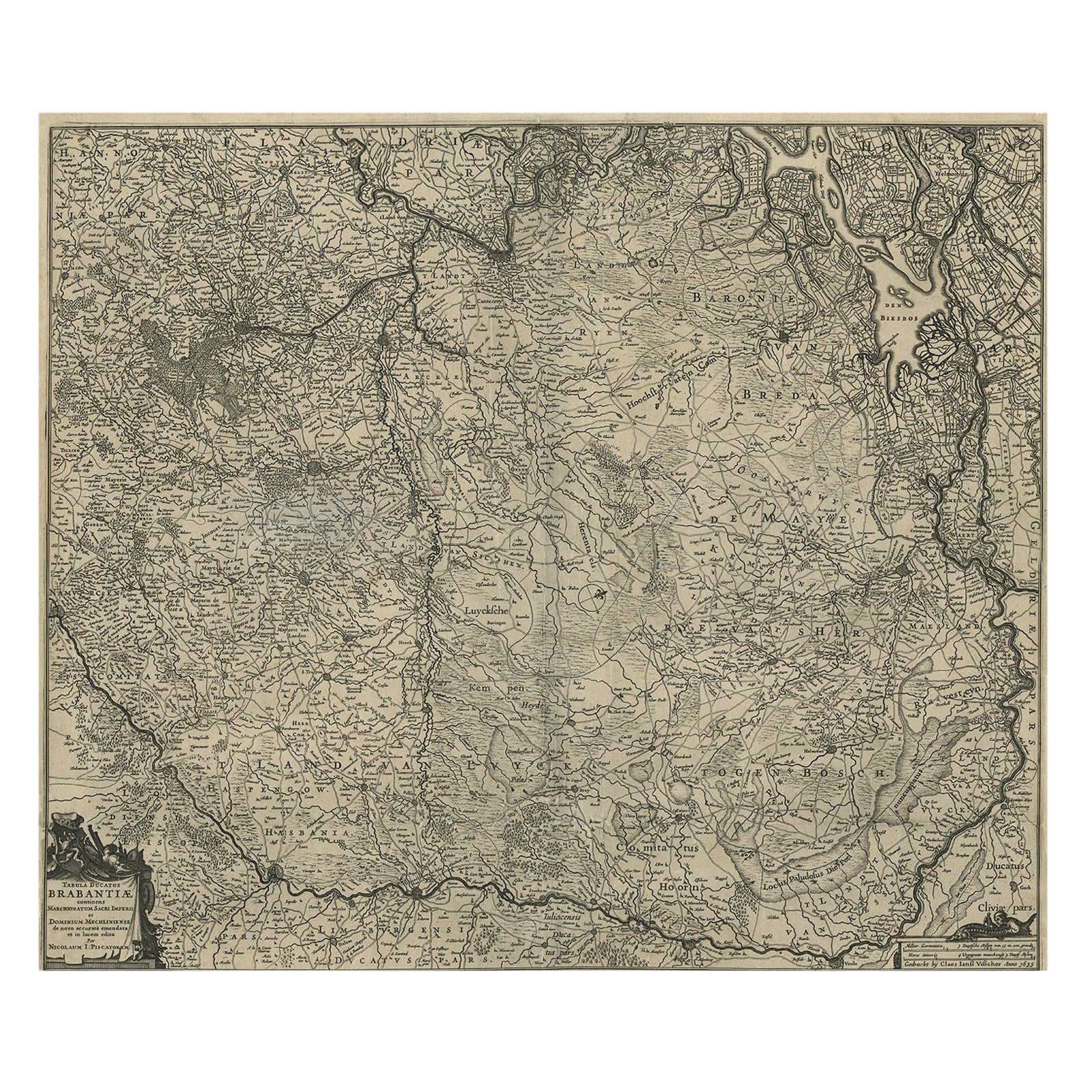
- Detailed Map of the South of the The Netherlands & The North of Belgium, ca.1680Located in Langweer, NLAntique map titled 'Tabula Ducatus Brabantiae.' - Detailed map of the southern part of The Netherlands and the northern part of Belgium with Antwerp and Brussels. In the corner top l...Category
Antique 1680s Maps
MaterialsPaper


You May Also Like
- XL Old School Map of Belgium 'Printed by Procure', 1950sLocated in Oostende, BEXL Old school map of Belgium (Printed by Procure). Presumably from around 1950-1960.Category
Vintage 1950s Belgian Mid-Century Modern Maps
MaterialsMetal
- Detailed Model of Dutch Sailing Ship From the 1930s-1940sLocated in Opole, PLDetailed Model of Dutch Sailing Ship From the 1930s-1940s A faithfully reproduced model of a vessel dating back to the Interwar Period of the 20th ...Category
Early 20th Century Dutch Models and Miniatures
MaterialsWood
- Old Nautical Map of CorsicaLocated in Alessandria, PiemonteST/556/1 - Old map of Corsica isle, surveyed by Captain Hell, of the French Royal Navy in 1824, engraved and published on 1874, with additions and corre...Category
Antique Early 19th Century English Other Prints
MaterialsPaper
- Old Horizontal Map of EnglandBy TassoLocated in Alessandria, PiemonteST/520 - Old rare Italian map of England, dated 1826-1827 - by Girolamo Tasso, editor in Venise, for the atlas of M.r Le-Sage.Category
Antique Early 19th Century Italian Other Prints
MaterialsPaper
- Detailed Model of Dutch Sailing Ship Circa 1930s-1940sLocated in Opole, PLDetailed Model of Dutch Sailing Ship Circa 1930s-1940s A faithfully reproduced model of a vessel dating back to the Interwar Period of the 20th century. In particularly good condition.Category
Early 20th Century Dutch Models and Miniatures
MaterialsWood
- 1752 Vaugoundy Map of Flanders : Belgium, France, and the Netherlands, Ric.a002Located in Norton, MALarge Vaugoundy Map of Flanders: Belgium, France, and the Netherlands Colored -1752 Ric.a002 Description: This is a 1752 Didier Robert de Vaugondy map of Flanders. The map de...Category
Antique 17th Century Unknown Maps
MaterialsPaper


Recently Viewed
View AllMore Ways To Browse
Holland And Sons Furniture
Holland And Sons
Holland And Son
Large Map Of The World
Old World Antique Maps
Antique Old World Map
Old Antique World Map
Old World Antique Map
Antique Old Map Of The World
18th C Dutch
Dutch 16th Century Furniture
Antique Dutch Light
Belgium Map
School Maps
School Map
Holland Utrecht
Dutch School Antique
Large Antique Map Of The World