Items Similar to Detailed Map of the South of the The Netherlands & The North of Belgium, ca.1680

Want more images or videos?
Request additional images or videos from the seller
1 of 5
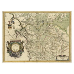
Detailed Map of the South of the The Netherlands & The North of Belgium, ca.1680
About the Item
Antique map titled 'Tabula Ducatus Brabantiae.' - Detailed map of the southern part of The Netherlands and the northern part of Belgium with Antwerp and Brussels. In the corner top left in Holland with Rotterdam partly on the map. Small cartouche with a coat of arms. Source unknown, to be determined.
Artists and Engravers: Made by 'Nicolaes Visscher' after an anonymous artist. The Visscher family were art and map dealers in Amsterdam during the 17th century. Funded by C. J. Visscher (1587-1652), the business was continued by his son and grandson both named Nicolas. Nicolas Visscher I was born 1618 in Wenns, Austria. He died 1679 in Linz. After the death of Nicolas II, his widow passed the business to Pieter Schenk.
- Dimensions:Height: 19.1 in (48.5 cm)Width: 22.25 in (56.5 cm)Depth: 0 in (0.02 mm)
- Materials and Techniques:
- Period:1680-1689
- Date of Manufacture:circa 1680
- Condition:Condition:Good. Margins cropped close to the platemark. A few light creases. Sheet backed with a thin Japanese paper (to reinforce margins). Original middle fold as issued. General age-related toning and/or occasional minor defects from handling.
- Seller Location:Langweer, NL
- Reference Number:
About the Seller
5.0
Platinum Seller
These expertly vetted sellers are 1stDibs' most experienced sellers and are rated highest by our customers.
Established in 2009
1stDibs seller since 2017
1,932 sales on 1stDibs
Typical response time: <1 hour
- ShippingRetrieving quote...Ships From: Langweer, Netherlands
- Return PolicyA return for this item may be initiated within 14 days of delivery.
More From This SellerView All
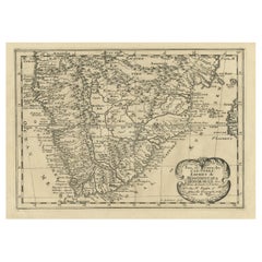
- Original Copperplate Engraved Detailed Map of South Africa, ca.1680Located in Langweer, NLAntique map titled 'Pays et Coste des Caffres Empires de Monomotapa (..)'. Detailed map of South Africa. Engraved by Antoine d'Winter for a Dutch edition of Sanson's pocket atlas...Category
Antique 1680s Maps
MaterialsPaper
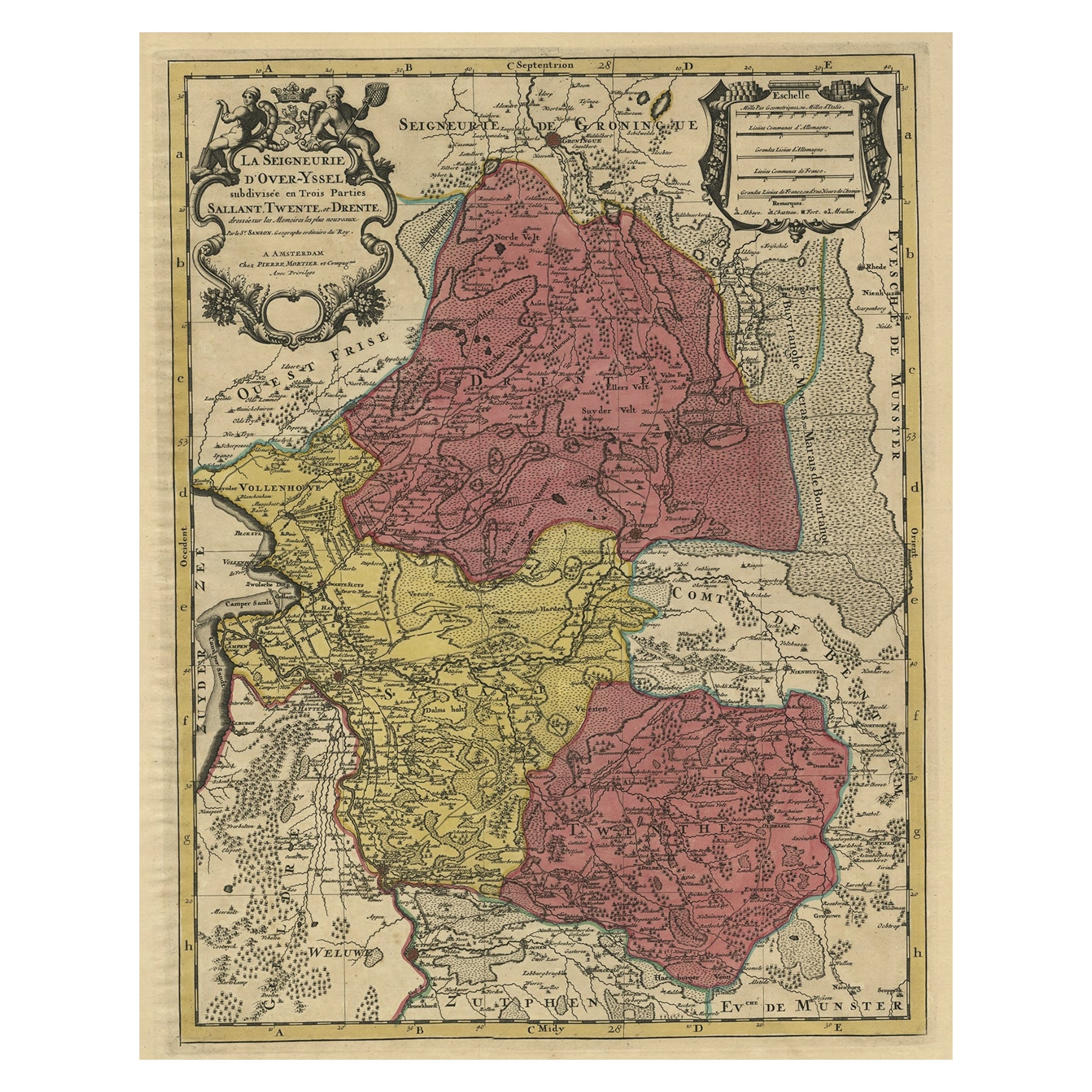
- Detailed Antique Map of the Province of Overijssel in the Netherlands, ca.1700Located in Langweer, NLAntique map titled 'La Seigneurie d'Over-Yssel subdivisee en Trois Parties, Sallant, Twente, et Drente.' Detailed map of the province of Overijssel in the Netherlands. From Jaill...Category
Antique Early 1700s Maps
MaterialsPaper
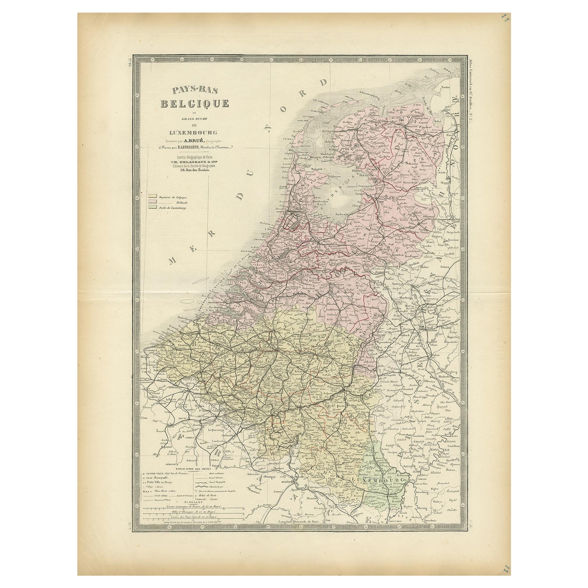
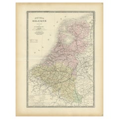
- Decorative Antique Map of the Netherlands and Belgium, ca.1875Located in Langweer, NLAntique map titled 'Pays-Bas Belgique (..)'. Large map of the Netherlands and Belgium. This map originates from 'Atlas de Géographie Moder...Category
Antique Late 19th Century Maps
MaterialsPaper
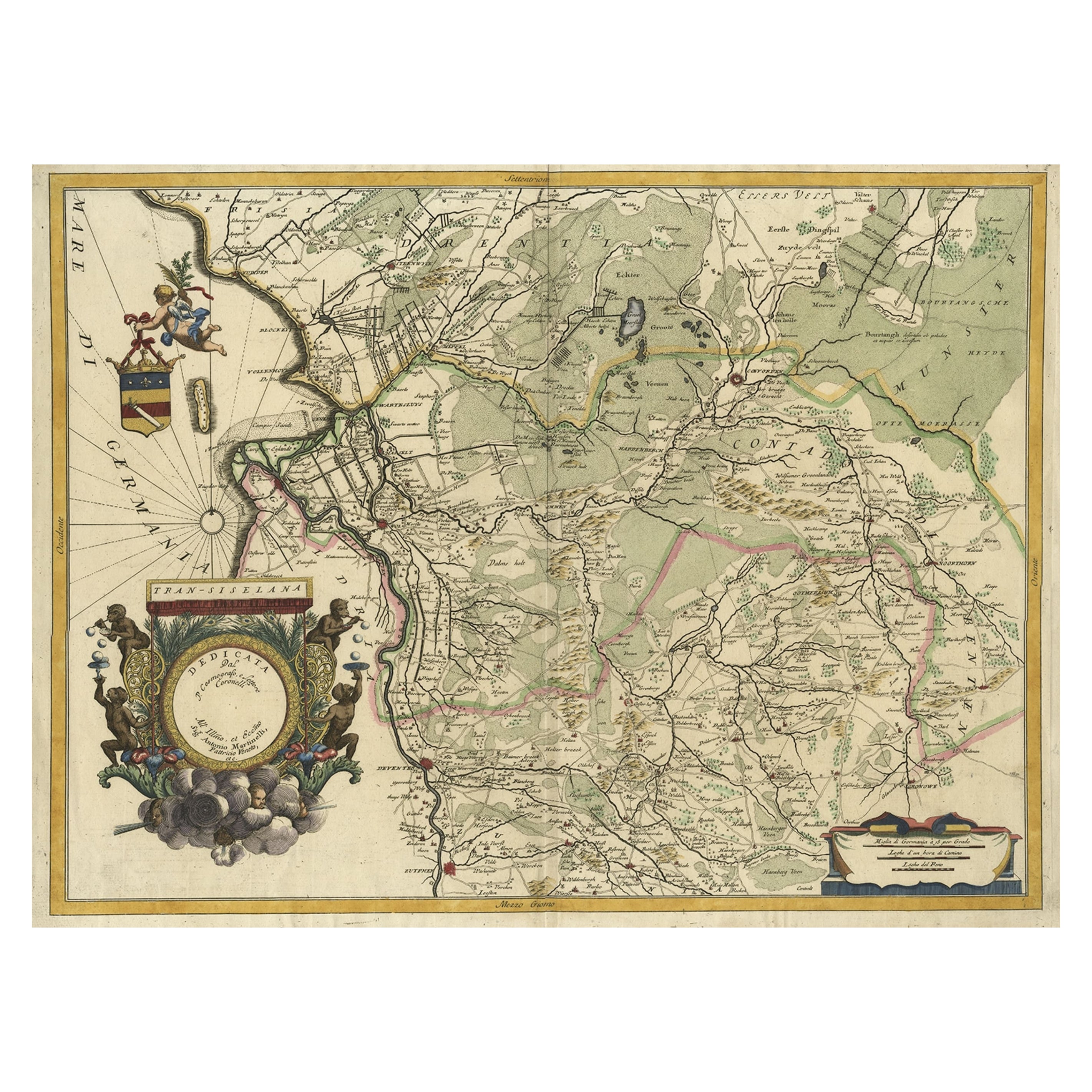
- Splendid Detailed Map of the Province of Overijssel in the Netherlands, ca.1692Located in Langweer, NLAntique map titled 'Tran-siselana'. Splendid detailed and decorative map of the province of Overijssel in the Netherlands by Vincenzo Coronelli. An elaborate title cartouche garlande...Category
Antique 1690s Maps
MaterialsPaper
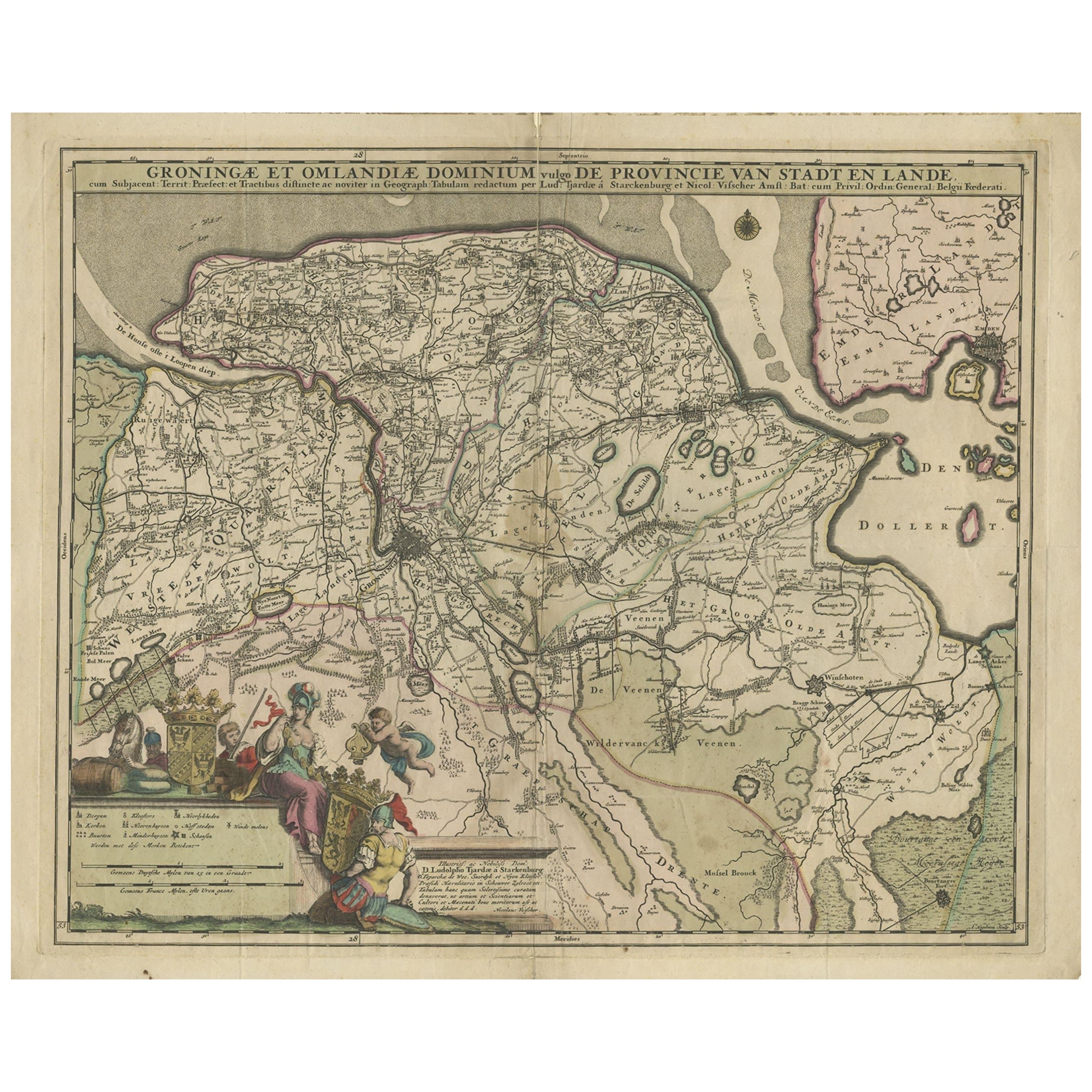
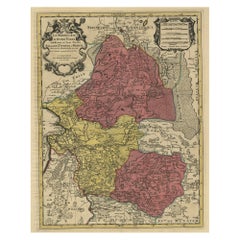
- Antique Map of the Province Groningen in The Netherlands, c.1680Located in Langweer, NLAntique map titled 'Groningae et Omlandiae Dominium vulgo de Provincie van Stadt en Lande'. Old map of the province of Groningen, the Netherlands. This map originates from 'Germani...Category
Antique 17th Century Maps
MaterialsPaper
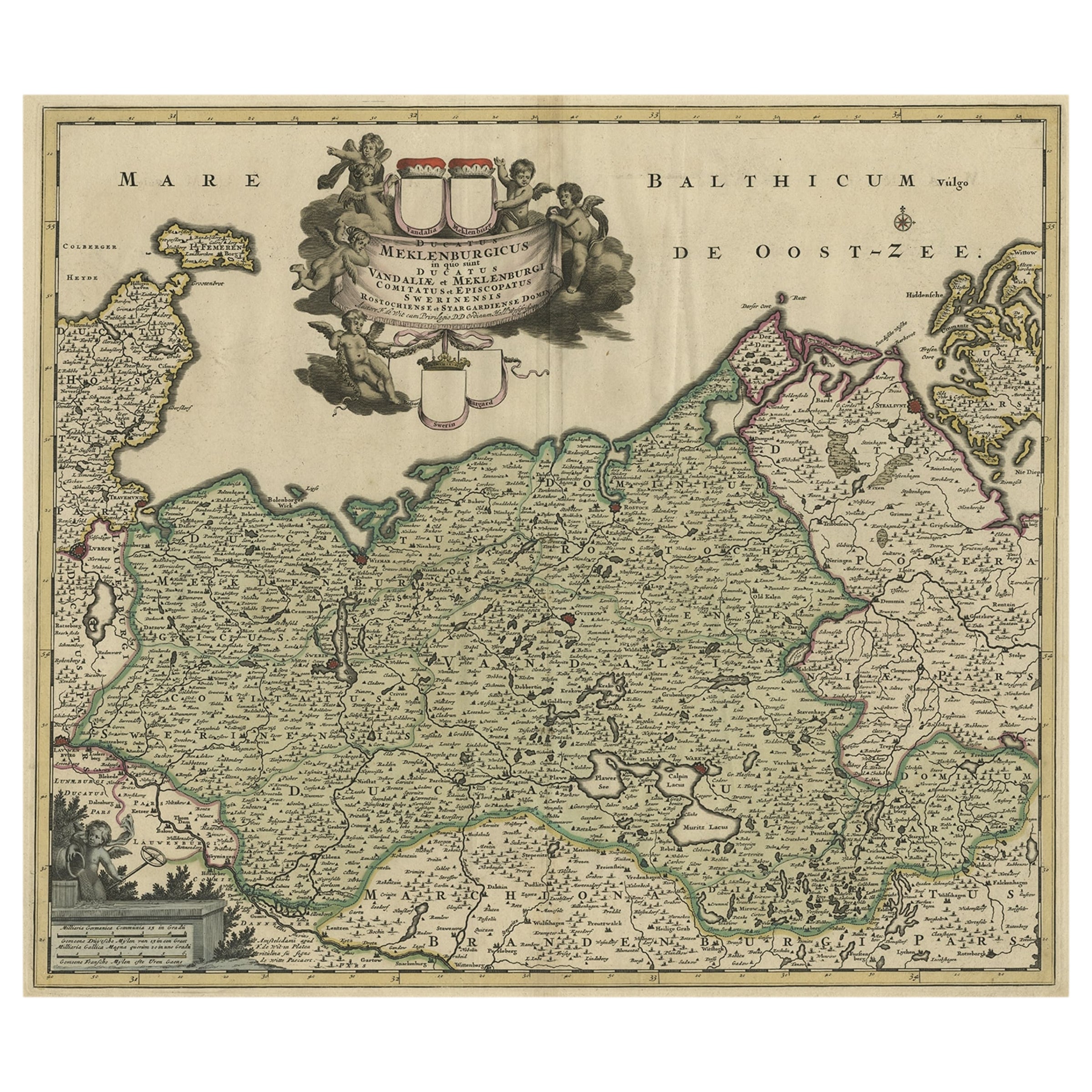
- A Handsome & Detailed Map of the Duchy of Mecklenburg & Pomerania, Germany, 1680Located in Langweer, NLAntique map titled 'Ducatus Meklenburgicus in quo sunt Ducatus Vandaliae et Meklenburgi Ducatus et Comitatus Swerinensis.' A handsome and detailed map of the Duchy of Mecklenburg...Category
Antique 1680s Maps
MaterialsPaper
You May Also Like
- New Map of North America from the Latest Discoveries, 1763Located in Philadelphia, PAA fine antique 18th century map of the North American seaboard. Entitled "A New Map of North America from the Latest Discoveries 1763". By the Cartographer/Engraver - John Spil...Category
Antique Mid-18th Century English Georgian Maps
MaterialsPaper
- Original Antique Map of The Netherlands, Sherwood, Neely & Jones, Dated 1809Located in St Annes, LancashireGreat map of The Netherlands Copper-plate engraving by Cooper Published by Sherwood, Neely & Jones. Dated 1809 Unframed.Category
Antique Early 1800s English Maps
MaterialsPaper
- Original Antique Map of The Netherlands, Engraved by Barlow, Dated 1807Located in St Annes, LancashireGreat map of Netherlands Copper-plate engraving by Barlow Published by Brightly & Kinnersly, Bungay, Suffolk. Dated 1807 Unframed.Category
Antique Early 1800s English Maps
MaterialsPaper
- Large Antique 1859 Map of North AmericaLocated in Sag Harbor, NYThis Map was made by Augustus Mitchell in 1859 It is in amazing condition for being 163 years old. This price is for the rolled up easy to ship version of this piece. I will be Frami...Category
Antique Mid-19th Century American Maps
MaterialsCanvas, Paper

- North & South America: A 17th Century Hand-colored Map by Jansson & GoosBy Johannes JanssoniusLocated in Alamo, CAA 17th century hand-colored map of North & South America entitled "Americae Descriptio" by the cartographer Johannes Jansson, published in Jansson's Atlas Minor in Amsterdam in 1628....Category
Antique 1620s Dutch Maps
MaterialsPaper
- Original Antique Map of South America. C.1780Located in St Annes, LancashireGreat map of South America Copper-plate engraving Published C.1780 Two small worm holes to left side of map Unframed.Category
Antique Early 1800s English Georgian Maps
MaterialsPaper


Recently Viewed
View AllMore Ways To Browse
Belgian Dealers
Dealers In Belgium
Austrian Dealers
Belgium Map
Austrian 17th
Map Austria
Map Of Austria
Map Of Belgium
Amsterdam Coat Of Arms
Belgium Antique Map
Maps Brussels
Antique Map Art Collectibles
Antique Maps Art Collectibles
Antique Map Schenk
Visscher Amsterdam
Antique Map Of Austria
Wood Carvings Of Ships
Classroom Furniture Used