Items Similar to Terrestrial Table Globe by Félix Delamarche, Paris, 1821


Video Loading
Want more images or videos?
Request additional images or videos from the seller
1 of 20
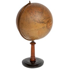
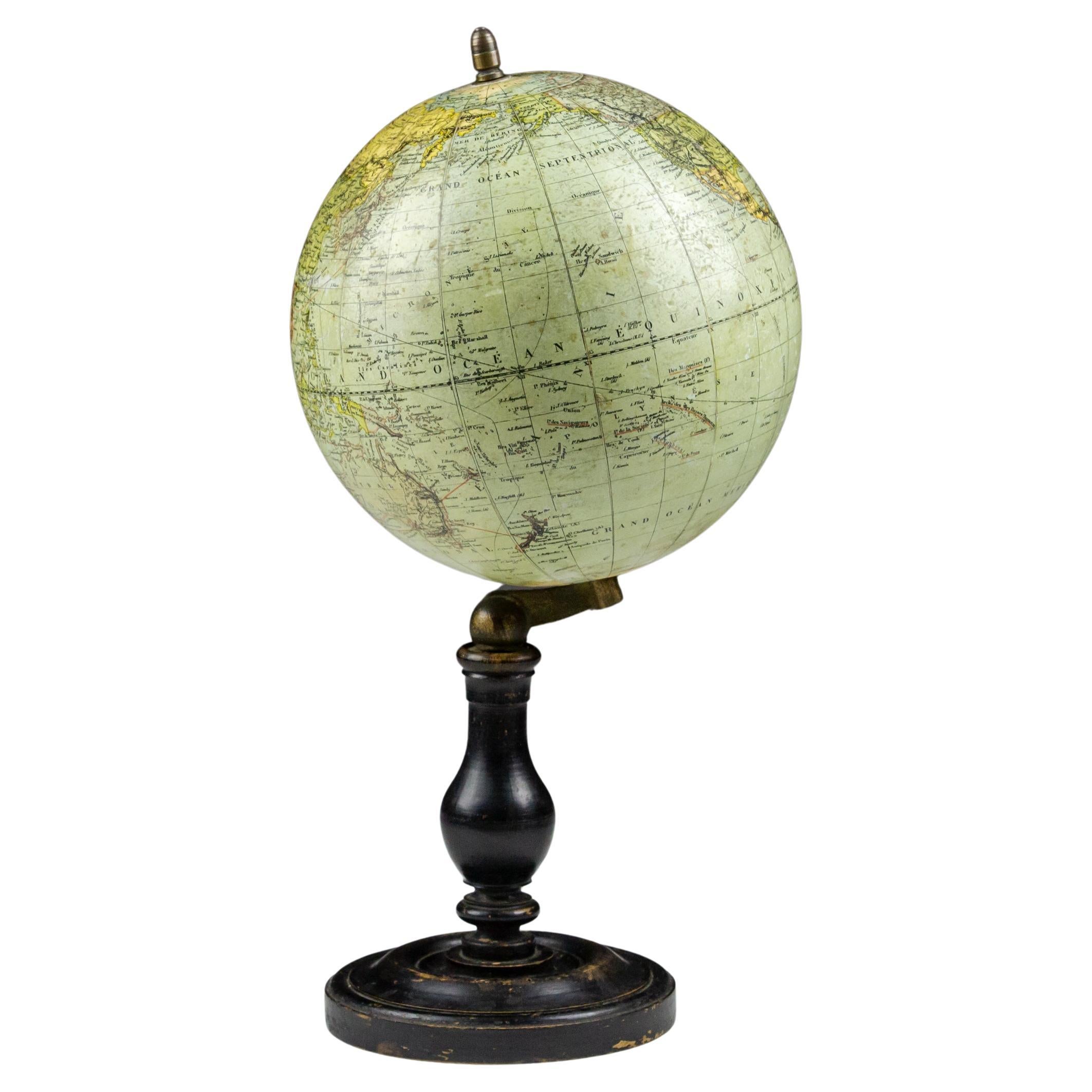
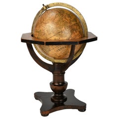
Terrestrial Table Globe by Félix Delamarche, Paris, 1821
About the Item
Terrestrial table globe
Félix Delamarche
Paris, 1821
It measures 20.47 in height, Ø max 14.17 in; the sphere Ø 9.44 in (h 52 cm x Ø max 36.5 cm; the sphere Ø 24 cm)
Wood, printed, papier-mâché and metal
It rests on its original turned wood column base.
State of conservation: there are small gaps, abrasions and stains on the surface. In some places very slight swellings on the surface can be noticed. The small circle of the hours is from a later period.
The globe is composed of two series of twelve printed paper gores, aligned and glued onto a sphere made with a chalky-based dough.
The meridian circle and the horizon circle are made of wood, also covered with printed paper.
The first has the degrees of latitude and the distances from the poles inscribed.
The circle of the horizon, on the other hand, details the amplitude, the direction of the winds, the days and months of the year and the names and symbols of the zodiac.
There are two distinct cartouches on the sphere.
One is located in the southern Indian Ocean, between South Africa and Australia. It bears the inscription:
Revu et Corrigé
par F.x Delamarche
A PARIS
Chez Felix Delamarche et Charles Dien
Rue du Jardinet n°. 13
1821
The second one is found in the South Pacific Ocean, between New Zealand and South America. It bears the inscription:
Réduction du
GLOBE TERRESTRE
dressé par Ordre
DU ROI.
Par le S. Robert De Vaugondy
Géographe.
On the rest of the surface, continents and oceans appear with numerous geographical indications and references to the main explorations, especially those by Cook, but also by others, both contemporary and from previous eras.
A large part of central-eastern Africa is unexplored and, in the area of the great lakes, only a part of the Malawi basin is sketched in. The "Enderby Land" discovered by Biscoe in 1831 on the coast of Antarctica, south of Africa, is not marked.
The North American coasts are well outlined, but Alaska is not described and is only partially traced; it would become part of the United States in 1867.
Various islands in the Pacific and Indian Oceans are indicated.
Australia (name definitively used since 1824) is still called "Nouvelle Hollande", while Tasmania is already represented as an island; it was circumnavigated by Matthew Flinders in 1798.
Charles-François Delamarche (1740-1817) founded his laboratory around 1770 and, in a few years, he became the most famous French cartographer and globe maker between the 18th and 19th centuries. After having acquired the laboratory of the late Didier Robert de Vaugondy (1723-1786; himself a renowned cartographer who continued the family business founded by his grandfather Nicolas Sanson in the seventeenth century) and after having purchased, between 1788 and around 1800, the businesses of Jean-Baptiste Fortin (1750-1831) and Jean Lattré (around 1750-1800), he began to call himself "Successeur de MM. Sanson and Robert de Vaugondi, Géographes du Roi and de M. Fortin, Ingénieur-mécanicien du Roi pour les globes et les sphères".
Thus, at the end of the eighteenth century, Delamarche possessed the warehouse stocks, as well as the manufacturing skills of the globes of his main rivals in Paris.
In addition to this aggressive acquisition policy, the key to his success also lay in the combination of high-quality cartography combined with extremely attractive globes and armillary spheres; and, of course, its famous red paint finishing touch.
His laboratory was located in Rue de Foin St Jacques "au Collège Me. (or "Mtre") Gervais" in the Latin Quarter of Paris until around 1805, when he moved to rue du Jardinet n. 13.
On the death of Charles-François in 1817, the reins of the company passed to his son Félix (1779-1835), who continued to publish, often in collaboration with the engraver Charles Dien, Senior. In 1835 the company first moved to rue du Jardinet n. 12 and a little later to rue du Battoir n. 7.
Bibliography:
- Van der Krogt P., Old Globes in the Netherlands, Utrecht 1984, pp. 98-99;
- Van der Krogt P. e Dekker E., Globes from the Western World, London 1993, p. 78;
- Dekker E., et al., Globes at Greenwich: A Catalogue of the Globes and Armillary Spheres in the National Maritime Museum, Greenwich, London, 1999, pp. 321-322 for the story of the Delamarche family.
- Dekker E., Catalogue of Orbs, Spheres and Globes, Firenze-Milano 2004. The globes and spheres kept in the Museo Galileo in Florence are listed and described; pp. 164-166 n. 51-52 (inv. n. 3705 e n. 3369) a pair of globes, the terrestrial and the celestial, by Félix Delamarche larger than ours, but with the same year, 1821, of publication.
- Creator:Félix Delamarche (Maker)
- Dimensions:Height: 20.48 in (52 cm)Width: 14.38 in (36.5 cm)Depth: 14.38 in (36.5 cm)
- Style:Restauration (Of the Period)
- Materials and Techniques:
- Place of Origin:
- Period:
- Date of Manufacture:1821
- Condition:Wear consistent with age and use. There are small gaps, abrasions and stains on the surface. In some places very slight swellings on the surface can be noticed. The small circle of the hours is from a later period.
- Seller Location:Milano, IT
- Reference Number:1stDibs: LU4352233625962
About the Seller
4.3
Vetted Seller
These experienced sellers undergo a comprehensive evaluation by our team of in-house experts.
Established in 1860
1stDibs seller since 2018
19 sales on 1stDibs
Typical response time: 6 hours
Associations
International Confederation of Art and Antique Dealers' Associations
- ShippingRetrieving quote...Ships From: Milano, Italy
- Return PolicyA return for this item may be initiated within 14 days of delivery.
More From This SellerView All
- Ptolemaic Armillary Sphere Charles-François Delamarche Paris, 1805-1810 CircaBy Charles Francois DelamarcheLocated in Milano, ITCharles-François Delamarche Ptolemaic armillary sphere Paris, circa 1805-1810 Wood and papier-mâché covered with printed and partly hand-coloured paper It measures 15.74” in height, ...Category
Antique Early 1800s French Empire Scientific Instruments
MaterialsPaper, Wood
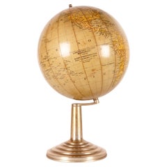
- Miniature Terrestrial Globe Newton & Son London, Post 1833, Ante 1858By Newton and SonLocated in Milano, ITMiniature Terrestrial Globe Newton & Son London, post 1833, ante 1858 Paper, papier-mâché, bronze and wood It measures: sphere diameter 2.95 in (7.6 cm); diameter of the wooden base 6.02 in (15.3 cm); height 8.36 in (21.24 cm). Weight: 2,067 lb. State of conservation: the globe still bears its original paint, but has various small gaps, abrasions and stains on the surface. The globe is hinged with two pins at the meridian circle, which is in turn inserted perpendicular to the horizon circle; this is supported by four semi-arches connected at the bottom by a small goblet-shaped foot, resting on a wooden bell-shaped base. Apart from the wooden base, the entire support structure is made of bronze; on the foot there are the scale reproductions of a compass, a telescope and an open book. The sphere is made of papier-mâché and is covered with twelve printed paper gores. In the North Pacific Ocean the globe bears a cartouche with the inscription (about 30% of the writing is illegible, but the missing parts can be easily integrated based on the rest): NEWTON’S New & Improved TERRESTRIAL Globe Published by Newton & Son 66 Chancery Lane LONDON On the globe, much of central Africa is empty and the great lakes Tanganyika and Victoria are not marked (Europeans would begin to explore the area after 1858). Canada is called "British Territory" and Alaska "Russian Territory" (it would become part of the United States in 1867). Australia already bears its modern name (until 1829 it had been called New Holland) and its coasts are completely designed; Tasmania is listed as an island (Matthew Flinders circumnavigated it in 1798). The routes of Cook's various voyages are plotted; both the route followed by Biscoe in 1831 and the "Land of Enderby" which he discovered on the coast of Antarctica, south of Africa, are marked. Bibliography P. Van der Krogt, Old Globes...Category
Antique 1840s English Early Victorian Maps
MaterialsBronze
- Pocket Globe by Nathaniel Hill, London 1754Located in Milano, ITNathaniel Hill Pocket globe London, 1754 The globe is contained in its original case, which itself is covered in shark skin. There are slight gaps in the original paint on the sphere. The case no longer closes. The sphere measures 2.6 in (6.8 cm) in diameter whereas the case measures 2.9 in (7.4 cm) in diameter. lb 0.24 (kg 0.11) The globe is made up of twelve printed paper gores aligned and glued to the sphere. In the North Pacific Ocean there is a scroll with the inscription: A New terrestrial Globe by Nath. Hill, 1754. The celestial globe is depicted on the inside of the box. On the terrestrial globe much of central and southern Africa is empty. North America bears only the name of some British colonies. It shows California as a peninsula and the northwest coast of America as "unknown parts" (Alaska is not described and is only partially delineated; it would become part of the United States in 1867). The route of Admiral Anson is traced (1740) and the trade winds are indicated by arrows. Australia, still named New Holland (the new name would be introduced in 1829), is part of the west coast. (See Van der Krogt, P., Old Globes in the Netherlands, Utrecht 1984, p. 146 and Van der Krogt, P. - Dekker, E., Globes from the Western World, London 1993, p. 115.) Nathaniel Hill (London, news from 1746 to 1768) had impeccable professional credentials: he had done his apprenticeship with Richard Cushee, who at the time was carrying out surveying work for John Senex's Surrey map...Category
Antique 1750s English George II Globes
MaterialsShagreen, Paper
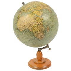
- German Globe by C. Abel-Klinger, Nuremberg, circa 1860By C. Abel-KlingerLocated in Milano, ITTerrestrial globe Artistic company C. Abel - Klinger Nuremberg, circa 1860 H cm 31 x 22 cm (12.20 x 8.66 in); sphere 14 cm (5.51 in) in diameter lb 2.30 (kg 1.04) State of conservation: good. On the sphere there are slight visible signs of accidental bumping at the poles, as well as on New Guinea and England (vertical and more visible); some ink stains, especially at the South Pole and on the meridian that crosses North America. The globe is composed of twelve whole gores of printed paper, juxtaposed and glued on a sphere made with a chalky base mixture. The circle of the meridian, made of brass...Category
Antique 1860s German Other Scientific Instruments
MaterialsWood, Paper
- Pair of English Globes by Cary, London, 1798 and 1800By Cary’sLocated in Milano, ITPair of 12-inch table globes John and William Cary London, 1798 and 1800 Some restored cracks and abrasions lb 11 each (kg 5) The two terrestrial and celestial globes rest in their original Dutch style stands with four supporting turned wood columns. Each one measures 18 in in height x 17 in in diameter with the diameter of the spheres measuring about 12 in; 46 cm in height x 43 cm in diameter x 31 cm diameter of the spheres. The 12 inch measure was one of the most frequently used by British manufacturers of globes of this period. Each globe is composed of two series of twelve printed paper gores, aligned and glued onto plaster spheres. The brass circle of the meridian bears engravings...Category
Antique Late 18th Century English George III Globes
MaterialsWood, Paper
- 18-inch Globe, Cary's, London, 1840By Cary’sLocated in Milano, ITJohn and William Cary Updated by George and John Cary Terrestrial Globe London, 1840 lb 22 (kg 10) Slight surface abrasions due to use. A small crack on the horizon circle. The globe rests in its original Dutch style stand with four supporting turned wood columns. It measures 26 in in height x 23.6 in in diameter with the diameter of the sphere measuring 18 in; 66 cm in height x 60 cm in diameter with the diameter of the sphere measuring 45.72 cm. The 18 inch...Category
Antique 1840s English Early Victorian Globes
MaterialsWood, Paper

You May Also Like
- Globe Table Terrestrial SwedishLocated in BUNGAY, SUFFOLKA Swedish 12 inch terrestrial globe, circa 1900. Measure: height 59cm Just purchased more information to follow.Category
Antique 1890s Swedish Baroque Revival Maps
MaterialsPaper
- Early 20th Century Terrestrial Globe by G. Thomas ParisBy G. Thomas, ÉditeurLocated in Pease pottage, West SussexEarly 20th Terrestrial Globe by G. Thomas. 44 Rue ND des Champs, Paris. Found on original ebonised turned base and brass fittings. Paris, France Circa 1920.Category
Early 20th Century French Maps
MaterialsWood, Paper
- Terrestrial globe apres Mr. Rizzi Zannoni, Paris 1762.Located in Milan, ITDesigned to be hanged to the ceiling, terrestrial globe, made out of paper machè and wood, brass hook. It is reported in the cartouche of the globe: globe terrestre d’après Mr. Rizz...Category
Antique Mid-18th Century French Scientific Instruments
MaterialsBrass
- Terrestrial globe, Italy 1940.Located in Milan, ITTerrestrial globe, physical and political, in paper mache on a round metal base. Cartographic design G. Pugno, lithographic typography C. Brandoni. Italian globe laboratory, Turin, I...Category
Mid-20th Century Italian Scientific Instruments
MaterialsMetal
- Antique Terrestrial Globe Published in 1940s by Girard Barrère et Thomas, ParisLocated in Milan, ITTerrestrial globe published in the 1940s by Girard Barrère et Thomas 17, Rue de Buci Paris. Turned wooden base, papier mâché sphere covered with paper printed by engraving on copper ...Category
Vintage 1940s French Scientific Instruments
MaterialsWood, Paper
- Vintage Terrestrial Globe, 1970s, CzechoslovakiaLocated in Prague 8, CZThis Vintage Terrestrial globe was made in the 1970s in the former Czechoslovakia for school supply. It's made of plastic, wood and cardboard. It´s in good Vintage condition. M...Category
Late 20th Century Czech Mid-Century Modern Models and Miniatures
MaterialsIron