Items Similar to Organic Ammonite Vase by Schäffenacker, Modernist c. 1950


Want more images or videos?
Request additional images or videos from the seller
1 of 13
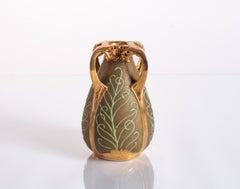
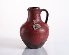
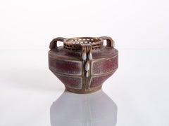
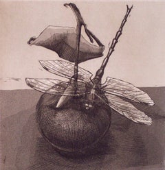
Helmut Friedrich SchäffenackerOrganic Ammonite Vase by Schäffenacker, Modernist c. 19501950
1950
About the Item
Hand-glazed, ammonite-shaped vase in a deep rust color made by Helmut Schäffenacker. Numbered in the base. Form V-6.
Helmut Schäffenacker founded Atelier Schäffenacker in West Germany in 1948. His studio worked in ceramics, bronze, stone, wood, paper, and metals, producing everything from vases, bowls, wall panels, sculptures, and paintings for private sale and for public works of art until he retired at 72 years old.
- Creator:Helmut Friedrich Schäffenacker (1921 - 2010, German)
- Creation Year:1950
- Dimensions:Height: 9.5 in (24.13 cm)Width: 10.5 in (26.67 cm)Depth: 2.75 in (6.99 cm)
- Medium:
- Movement & Style:
- Period:
- Condition:
- Gallery Location:Chicago, IL
- Reference Number:1stDibs: LU1493212546652
About the Seller
5.0
Vetted Seller
These experienced sellers undergo a comprehensive evaluation by our team of in-house experts.
Established in 1999
1stDibs seller since 2021
34 sales on 1stDibs
Typical response time: 1 hour
- ShippingRetrieving quote...Ships From: Chicago, IL
- Return PolicyThis item cannot be returned.
More From This SellerView All
- Peacock Vase by Paul Dachsel for Amphora, Art Nouveau c. 1900Located in Chicago, ILCeramic vase designed by Paul Dachsel for Amphora featuring delicate gold cross-hatching and relief elements to evoke peacock feathers. Polished gold glaze around mouth, on handles, and base relief...Category
Early 1900s Art Nouveau More Art
MaterialsCeramic
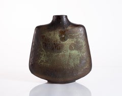
- Rustic Pitcher Vase by Carstens Luxus, Fat Lava, Mid-Century Modern c. 1967Located in Chicago, ILThis large ceramic vase from the Carstens Luxus line features a rugged volcanic lava finish in an earthy shade of garnet. Stamped in the base, and numbered, with original Carstens Lu...Category
1960s Modern More Art
MaterialsCeramic
- Shoulder Vase by Carstens-Tönnieshof Atelier Series, Modernist c. 1960Located in Chicago, ILA large ceramic shoulder vase by Carstens-Tönnieshof from its high-end Atelier Series helmed by designer Gerda Heuckeroth. This form is accented by textured glazes in hues of green, ...Category
1960s Post-War More Art
MaterialsCeramic
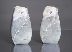
- Rare Earthenware Peacock Feather Vases by Clement Massier, Art Nouveau c. 1900By Clement MassierLocated in Chicago, ILA pair of exceptional earthenware vases by Clément Massier in a unique rectangular form, featuring albino peacock feathers enhanced by accents of purple and gold glazing. As Massier ...Category
Early 1900s Art Nouveau More Art
MaterialsCeramic
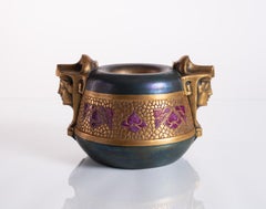
- Art Nouveau Egyptian Sphinx Bowl by Ernst-Wahliss c. 1900Located in Chicago, ILUnique earthenware bowl featuring a pair of golden Egyptian sphinxes and stylized purple flowers in an incised pattern, with an iridescent glaze of rich green, blue, and purple hues....Category
1910s Art Nouveau More Art
MaterialsCeramic
- Secessionist Vase with Raindrops by Paul Dachsel c. 1900By Paul DachselLocated in Chicago, ILA low naturalistic vase in a rare carmine color of red with purple overtones, featuring an opalescent raindrop ornamentation. Whereas earlier Art Nouveau pottery focused on asymmetri...Category
Early 1900s Art Nouveau More Art
MaterialsCeramic
You May Also Like
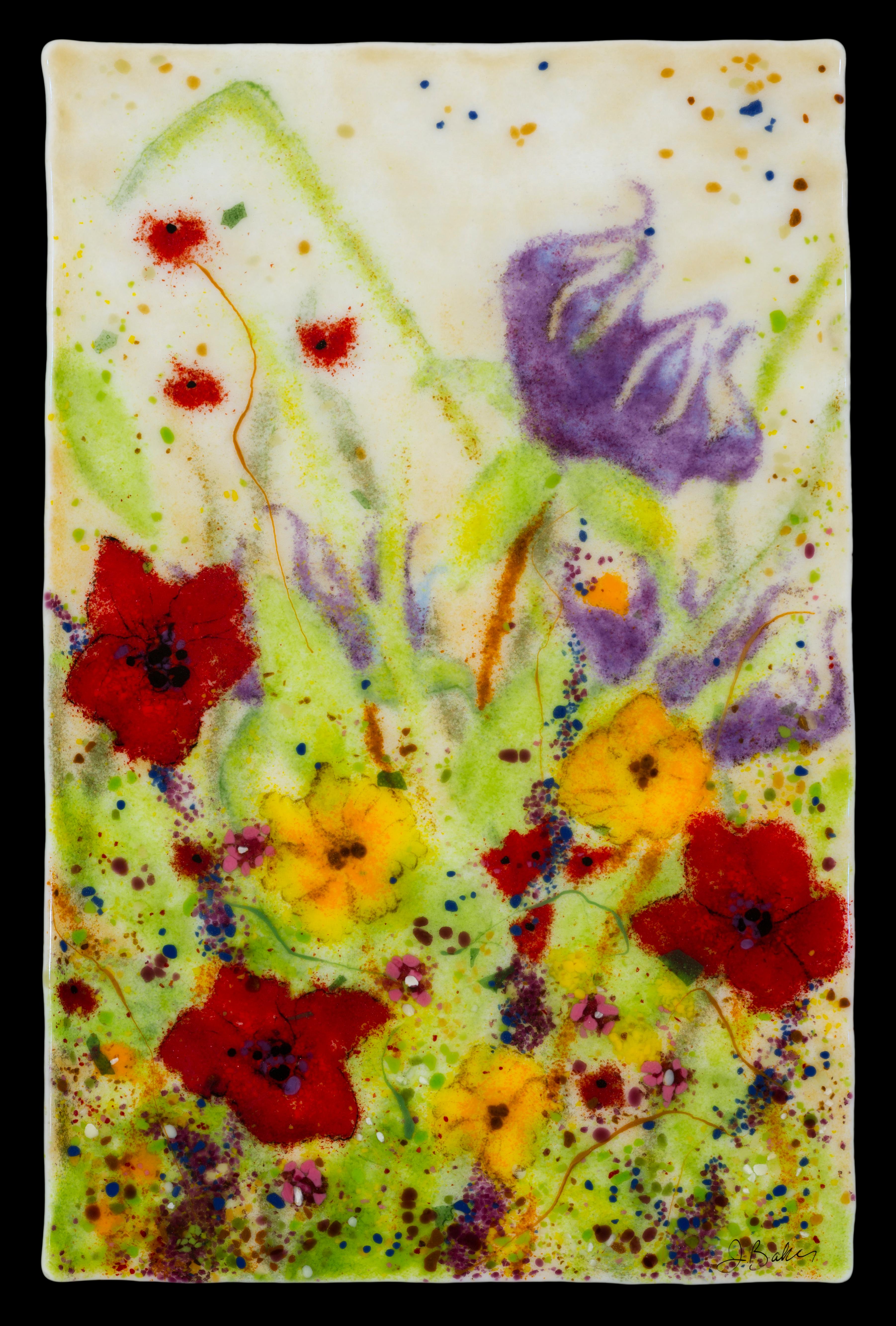
- Glass Wall art by Jennifer Baker Flower scene in Glass, Red, Purple, FloralBy Jennifer BakerLocated in Benahavis, ESThis floral, kiln formed glass artwork was created using layers of hand placed glass pieces. The piece is made to hang on a wall and is backed with a...Category
2010s Naturalistic More Art
MaterialsGlass
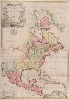
- one of the earliest large-scale English maps of North AmericaBy John SenexLocated in London, GBone of the earliest large-scale English maps of North America SENEX, John. North America Corrected from the Observations Communicated to the Royal Society at London, and the Royal Academy at Paris. By John Senex F.R.S. 1710. To the Honorable Anthony Hammond Esq. One of the Comissioners of Her Maj[es]ties Navy. This Map his humbly Dedicated and Presented by his Obliged Servants. John Senex F.R.S., 1710 [-1728]. A fine map of North and Central America, with the West Indies. One of the earliest large-scale English maps of North America. It represents a British attempt to consolidate new information about the region and borrows data from such recently published sources as Delisle’s landmark Carte du Mexique et de la Floride and Carte de la Canada. Senex improves upon De L'Isle's work with a fine depiction of the Great Lakes region and the most accurate definition of the lower Mississippi River and its delta by an English cartographer of the period. Several of the most important and controversial cartographic discoveries of the period are discussed at length, including Lahontan’s mythical Long River and the Salt Lake east of the Country of the Mozeemleck’s, both of which are also depicted in remarkable (albeit fanciful) detail. Sir William Phipps discovery of Spanish wrecks off the coast of the Caicos and Southern Bahamas is also noted. Senex also extended the map’s coverage to the Canadian Arctic and the Terra Incognita above Baffin’s Bay. Present-day Oklahoma and Texas are part of La Floride, considered at the time to be a possession of the French. The Red River and the Indian villages of East Texas are portrayed accurately, but Senex, following Delisle, incorrectly placed many Texas rivers...Category
1710s Naturalistic More Art
MaterialsWatercolor, Engraving
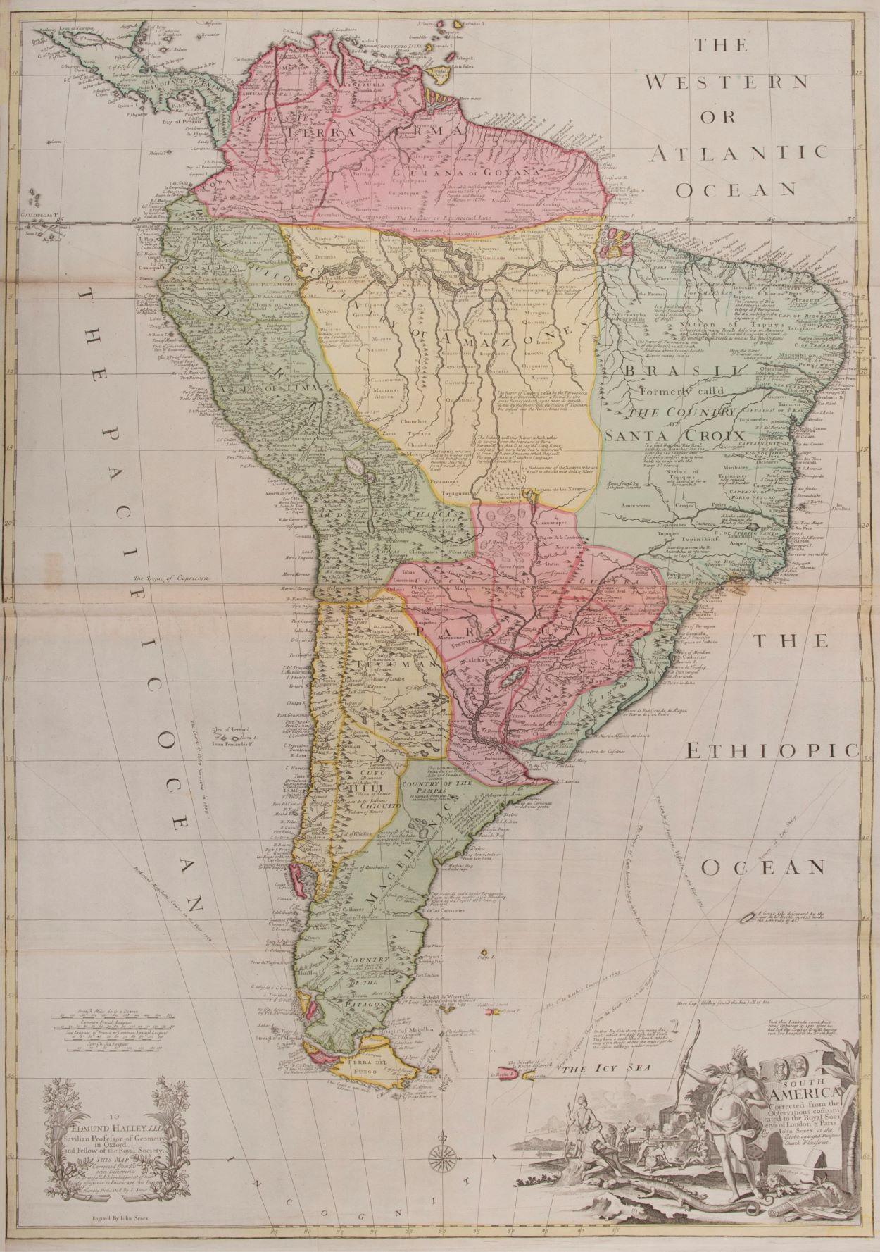
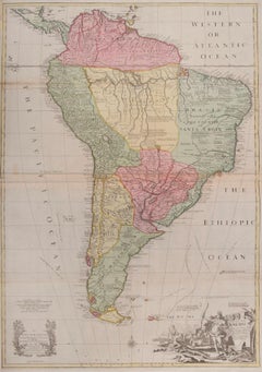
- South AmericaBy John SenexLocated in London, GBSouth America SENEX, John. South America Corrected from the Observations Communicated to the Royal Society’s of London & Paris. By John Senex. To Edmund Halley. LLD. Savilian Professor of Geometry in Oxford and Fellow of the Royal Society. This Map corrected from His own Discoveries In gratefull Acknowledgement of his Ready assistance to Encourage this Designe is Humbly Dedicated. John Senex, at the Globe against St Dunstans Church, Fleetstreet, London 1710 [-1728]. John Senex (1678-1740) was one of the foremost mapmakers in England in the early eighteenth century. He was also a surveyor, globemaker, and geographer. As a young man, he was apprenticed to Robert Clavell, a bookseller. He worked with several mapmakers over the course of his career, including Jeremiah Seller and Charles...Category
1710s Naturalistic More Art
MaterialsWatercolor, Engraving
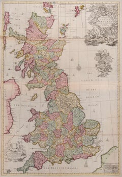
- Great BritainBy John SenexLocated in London, GBGreat Britain SENEX, John. A New Map of Great Britain Corrected from the Observations communicated to the Royal Society at London. By John Senex F.R.S. To the Right Hono[ra]ble William Connelly ESQ. One of the Commissioners of His Maj[es]ties Revenue, Speakerof the Hono[a]ble House of Commons, and one of His Maj[es]ties most Hono[ra]ble Privy Council for Ye Kingdom of Ireland. This Map is dedicated by John Senex. John Senex F.R.S. 1710 [-1728]. John Senex (1678-1740) was one of the foremost mapmakers in England in the early eighteenth century. He was also a surveyor, globemaker, and geographer. As a young man, he was apprenticed to Robert Clavell, a bookseller. He worked with several mapmakers over the course of his career, including Jeremiah Seller and Charles Price...Category
1710s Naturalistic More Art
MaterialsWatercolor, Engraving
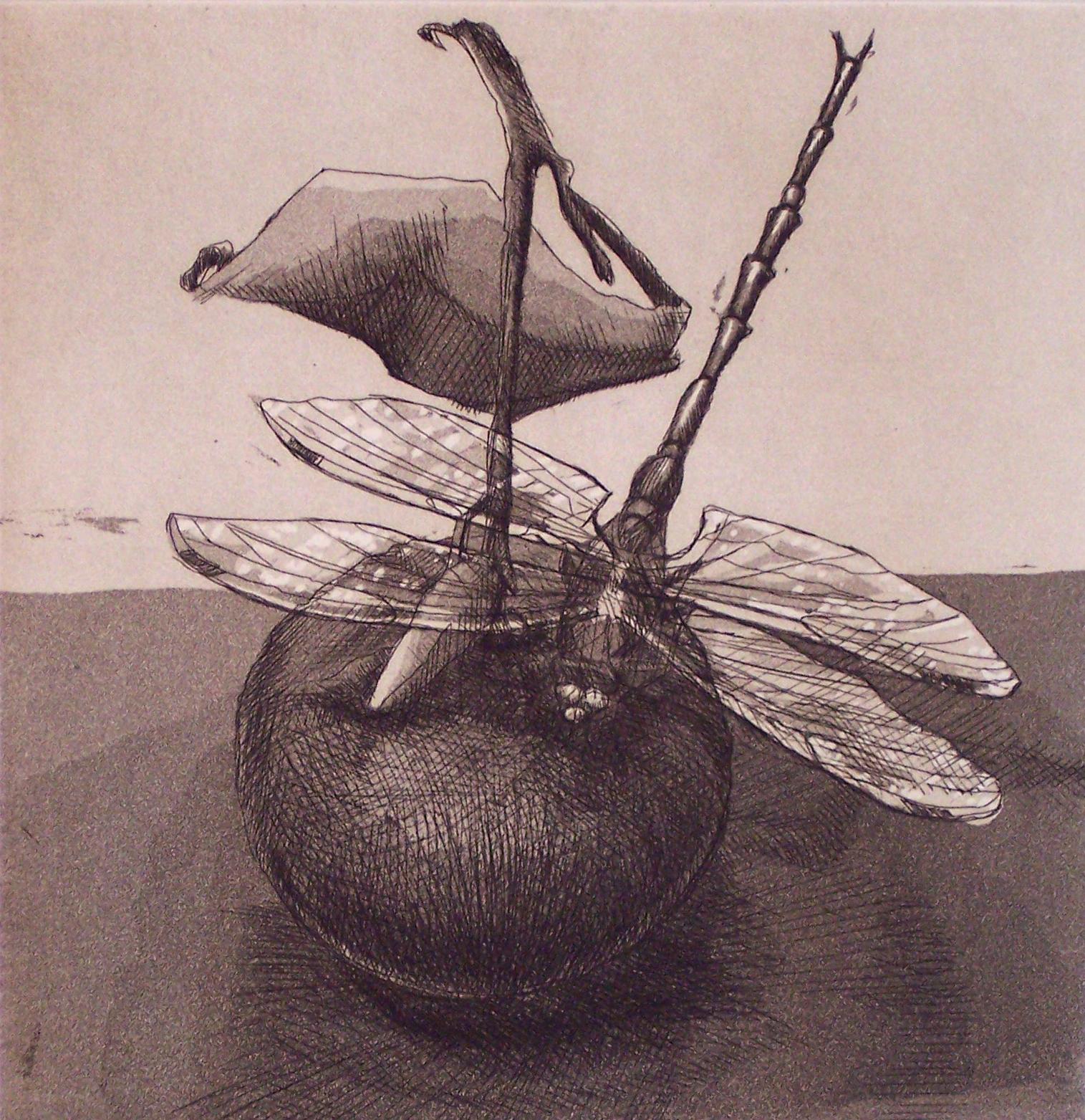
- Dragonfly #3 : Monochrome etchingBy Lisa DinhoferLocated in New York, NYLisa Dinhofer's work is presented in a realist style, deftly creating meticulous portraits of creatures - dragonflies, turtles, birds, bats and grasshoppers - that comprise her surro...Category
1990s Naturalistic More Art
MaterialsEtching
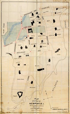
- Plan of a Part of Newport, R. I. Showing Changes... O. H. P, Belmont, Esq.Located in New York, NYPLAN OF A PART OF NEWPORT, R.I. SHOWING CHANGES IN HIGHWAYS ASKED FOR BY O.H.P. BELMONT, ESQ. The original ink and watercolor plan on paper from 1907. The plan is extremely large; if fully assembled it would measure no less than 11.5 feet in height and 6.5 feet in breadth. Segmented and backed on modern linen in four sections – each section is 70 x 39 inches. This grand oversized folding map can be folded down to four sections each 17.5 x 11 inches and stored in a modern made leather and marble paper case 18 x 11.75 x 3 inches. Text continues, "Prepared for Charles Warren Lippitt at the office of J. P. Cotton, C.E. Newport, R.I. Oct. 28, 1907." A fine manuscript plan of the Bellevue neighborhood of Newport, depicting the street layout and the detailed footprints of the area’s many mansions. The plan was produced at the behest of Charles Warren Lippett (1846-1924), who served as governor of Rhode Island from 1895-1897. The Lippett “Breakwater” mansion is also shown on this plan, situated at the southernmost tip of the peninsula. Though the circumstances are unclear, Lippitt seems to have requested the plan be drawn out of some concern for road construction proposed by Oliver Hazard Perry...Category
Early 20th Century Naturalistic More Art
MaterialsInk, Watercolor

Recently Viewed
View AllMore Ways To Browse
Organic Art
Indian Paiting Antique
Marmol Sculpture
Reuben Rubin
Jeff Faerber
John Caple
Jordan Mcdonald
Louis Vuitton In Ottawa
Folk Art Puffin
Helmut Newton Poster
Hockney Alphabet
Jackie De G
Hermes Nautical Napkins Placemats
Hermes Nautical Napkins
Vintage Pop Art Background
Disney Art Cel
Louis Vuitton Madrid
Scooby Doo Cel