Want more images or videos?
Request additional images or videos from the seller
1 of 5
John SenexSouth America
$4,079.58
£3,000
€3,499.59
CA$5,695.07
A$6,168.44
CHF 3,267.08
MX$74,628.90
NOK 41,072.25
SEK 38,288.06
DKK 26,136.51
About the Item
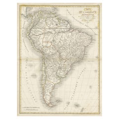
South America
SENEX, John.
South America Corrected from the Observations Communicated to the Royal Society’s of London & Paris. By John Senex. To Edmund Halley. LLD. Savilian Professor of Geometry in Oxford and Fellow of the Royal Society. This Map corrected from His own Discoveries In gratefull Acknowledgement of his Ready assistance to Encourage this Designe is Humbly Dedicated.
John Senex, at the Globe against St Dunstans Church, Fleetstreet, London 1710 [-1728].
John Senex (1678-1740) was one of the foremost mapmakers in England in the early eighteenth century. He was also a surveyor, globemaker, and geographer. As a young man, he was apprenticed to Robert Clavell, a bookseller. He worked with several mapmakers over the course of his career, including Jeremiah Seller and Charles Price. In 1728, Senex was elected as a Fellow of the Royal Society, a rarity for mapmakers. The Fellowship reflects his career-long association as engraver to the Society and publisher of maps by Edmund Halley, among other luminaries. He is best known for his English Atlas (1714), which remained in print until the 1760s. After his death in 1740 his widow, Mary, carried on the business until 1755. Thereafter, his stock was acquired by William Herbert and Robert Sayer (maps) and James Ferguson (globes).
Double-page engraved map on 2 sheets joined, with full contemporary hand-colouring. Size: 960 mm by 653 mm, sheet size: 962 by 680 mm.
Some light soiling to folds and outer margins, tear to top and bottom margins, both repaired. Fold repaired.
- Creator:
- Dimensions:Height: 39 in (99.06 cm)Width: 26.75 in (67.95 cm)
- Medium:
- Movement & Style:
- Period:1710-1719
- Condition:
- Gallery Location:London, GB
- Reference Number:Seller: 1084481stDibs: LU1419212314342
About the Seller
5.0
Vetted Professional Seller
Every seller passes strict standards for authenticity and reliability
Established in 1979
1stDibs seller since 2020
19 sales on 1stDibs
Typical response time: 5 hours
- ShippingRetrieving quote...Shipping from: London, United Kingdom
- Return Policy
More From This Seller
View AllGreat Britain
By John Senex
Located in London, GB
Great Britain
SENEX, John.
A New Map of Great Britain Corrected from the Observations communicated to the Royal Society at London. By John Senex F.R.S. To the Right Hono[ra]ble William Connelly ESQ. One of the Commissioners of His Maj[es]ties Revenue, Speakerof the Hono[a]ble House of Commons, and one of His Maj[es]ties most Hono[ra]ble Privy Council for Ye Kingdom of Ireland. This Map is dedicated by John Senex.
John Senex F.R.S. 1710 [-1728].
John Senex (1678-1740) was one of the foremost mapmakers in England in the early eighteenth century. He was also a surveyor, globemaker, and geographer. As a young man, he was apprenticed to Robert Clavell, a bookseller. He worked with several mapmakers over the course of his career, including Jeremiah Seller and Charles Price...
Category
1710s Naturalistic More Art
Materials
Watercolor, Engraving
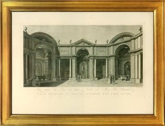
FEOLI. Vedute del Museo Pio-Clementino
By Vincenzo Feoli
Located in London, GB
Magnificent large plate illustrating the Vatican Museum at the end of the eighteenth century by Vincenzo Feoli (1750 - 1831) after Micenelli and Costa.
The Pio-Clementino museum, na...
Category
1790s Naturalistic Interior Prints
Materials
Engraving, Handmade Paper
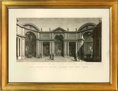
FEOLI. Vedute del Museo Pio-Clementino
By Vincenzo Feoli
Located in London, GB
Magnificent large plate illustrating the Vatican Museum at the end of the eighteenth century by Vincenzo Feoli (1750 - 1831) after Miccinelli and Costa.
The Pio-Clementino museum, n...
Category
1790s Naturalistic Interior Prints
Materials
Engraving, Handmade Paper
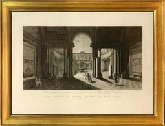
FEOLI. Vedute del Museo Pio-Clementino
By Vincenzo Feoli
Located in London, GB
Magnificent large plate illustrating the Vatican Museum at the end of the eighteenth century by Vincenzo Feoli (1750 - 1831) after Miccinelli and Costa.
The Pio-Clementino museum, n...
Category
1790s Naturalistic Interior Prints
Materials
Engraving, Handmade Paper
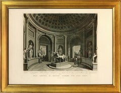
FEOLI. Vedute del Museo Pio-Clementino
By Vincenzo Feoli
Located in London, GB
Magnificent large plate illustrating the Vatican Museum at the end of the eighteenth century by Vincenzo Feoli (1750 - 1831) after Miccinelli and Costa.
The Pio-Clementino museum, n...
Category
1790s Naturalistic Interior Prints
Materials
Engraving, Handmade Paper
You May Also Like
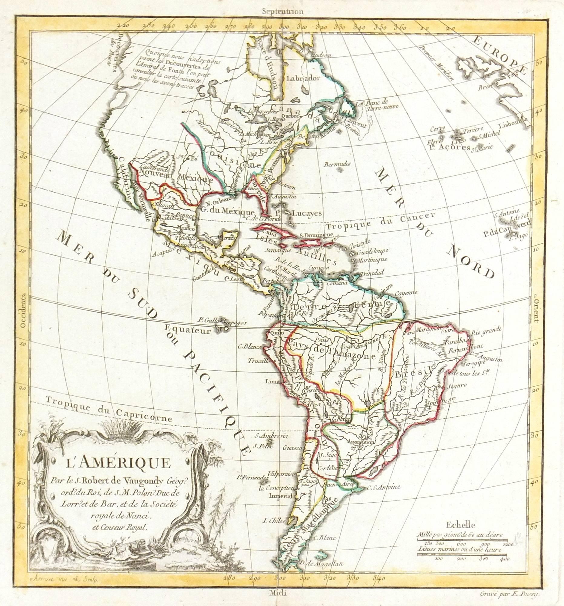
Map of Americas
Located in Houston, TX
Over 200 year old engraved map of Americas by Robert de Vaugondy from 1783. Original hand color. Shows North, Central and South Americas. Note the po...
Category
1780s More Prints
Materials
Ink, Watercolor, Handmade Paper

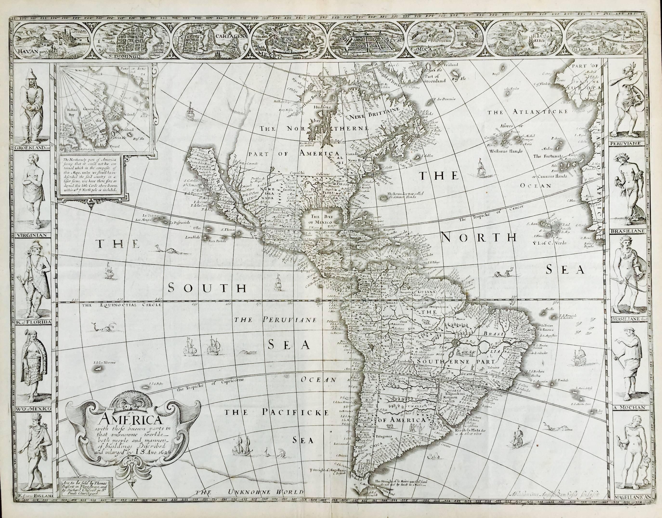
AMERICA
By John Speed
Located in Santa Monica, CA
IMPORTANT AMERICAN MAP - ONE OF THE FIRST TO SHOW CALIFORNIA as an ISLAND
JOHN SPEED (1552-1629)
AMERICA - With Those Known Parts In That Unknown Worlde (sic),
1626-(76)
(Burden 217 iv/iv) Engraving, uncolored. Engraved by Abraham Goos and
published by Thomas Basset and Richard Chiswell - 4th state of 4 in 1676
15 1/8 x 20 1/2” From “A Prospect of the Most Famous Parts of the
World”. Generally good condition. A repaired split in lower centerfold. This
is the most common version of this important map...
Category
1620s Old Masters Landscape Prints
Materials
Engraving

$4,080 Sale Price
52% Off
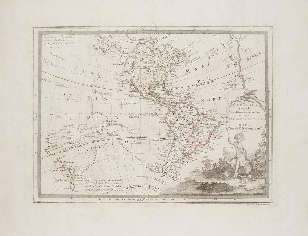
The Americas - Vintage Map - 18th century
Located in Roma, IT
The Americas is a very beautiful vintage map realized in the 18th century by an Italian cartographer.
Very good conditions, on the right side the inscript...
Category
18th Century Figurative Prints
Materials
Paper, Etching

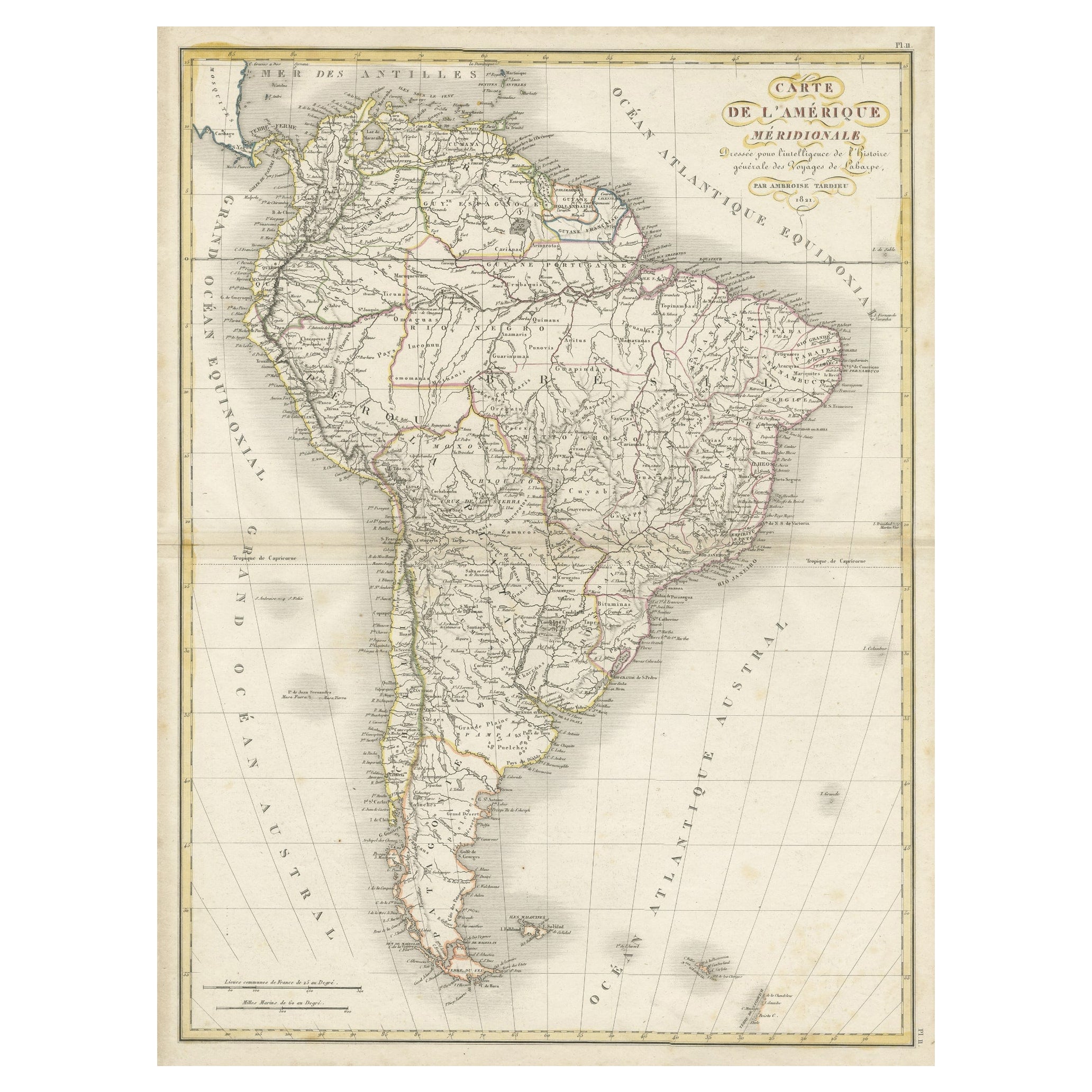
Scarce Antique Map of South America
Located in Langweer, NL
Antique map titled 'Carte de l'Amérique Méridionale'. Scarce map of South America, published in Paris in 1821. The map shows the continent in the ...
Category
Antique Early 19th Century Maps
Materials
Paper
$323 Sale Price
20% Off
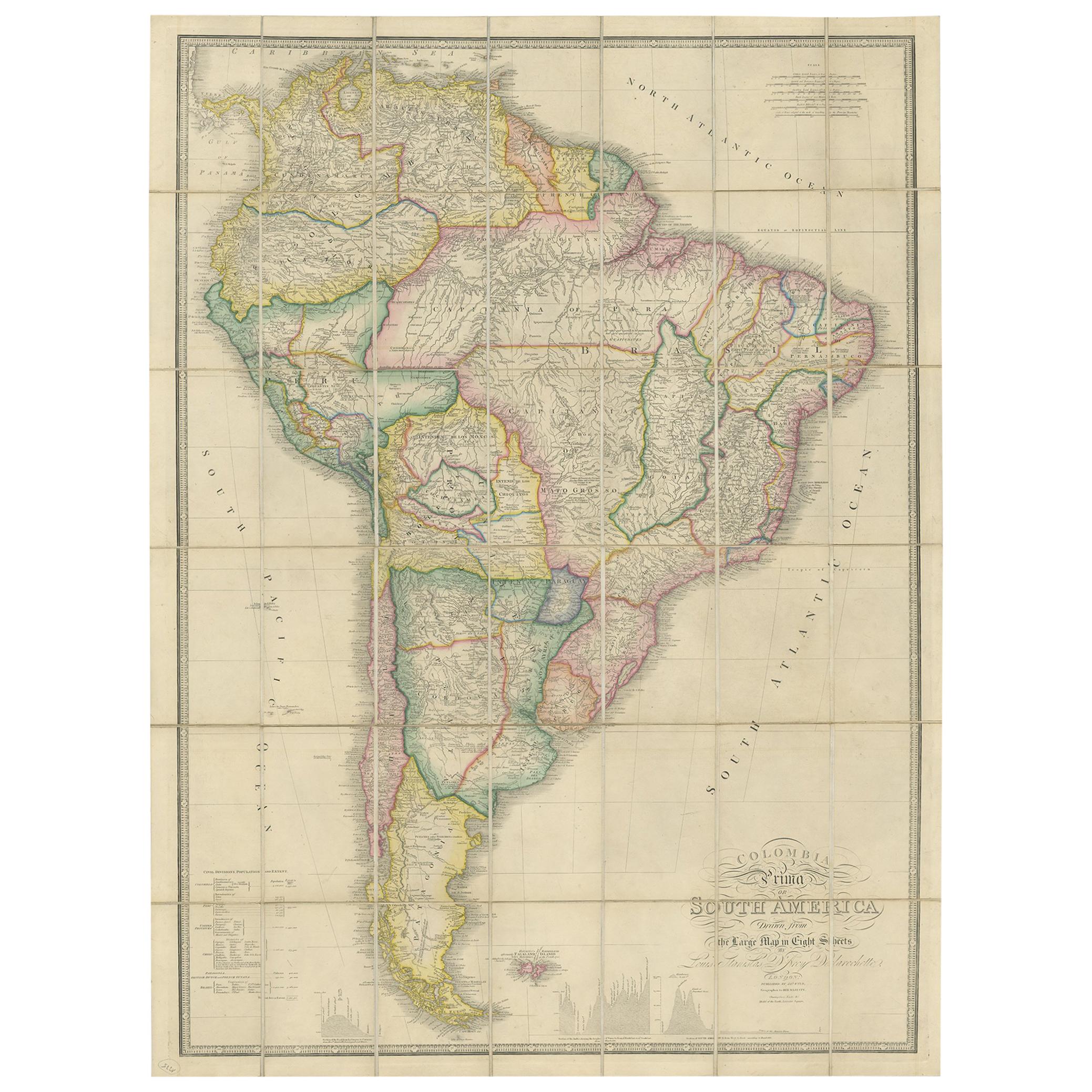
Antique Map of South America by Wyld, circa 1850
By J. Wyld
Located in Langweer, NL
Beautiful folding map of South America titled 'Colombia Prima or South America Drawn from the Large Map in Eight Sheets by Louis Stanislas D ' Arcy Delarochette'. Three insets in the...
Category
Antique Mid-19th Century British Maps
Materials
Paper

$1,379 Sale Price
20% Off
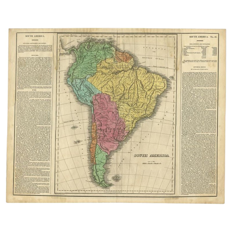
Interesting Original Antique Map of South America, 1822
Located in Langweer, NL
Antique map titled 'South America'.
Map of South America with attractive topography, surrounded on three sides by text on the history, geography, and economy of the continent. Sh...
Category
Antique 19th Century Maps
Materials
Paper
