Items Similar to University of Oxford Oxonia Illustrata 1675 engraving by David Loggan


Want more images or videos?
Request additional images or videos from the seller
1 of 5
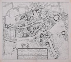
David LogganUniversity of Oxford Oxonia Illustrata 1675 engraving by David Loggan1675
1675
About the Item
To see our other views of Oxford and Cambridge, scroll down to "More from this Seller" and below it click on "See all from this Seller" - or send us a message if you cannot find the view you want.
David Loggan (1634-1692)
Frontispiece to the Oxonia Illustrata
Engraving
38 x 24 cm
The intricately engraved frontispiece to Loggan's 'Oxonia Illustrata', featuring cherubs bearing the volume's title on a banner and Minerva, goddess of wisdom, sitting before a panorama of Oxford's resplendent architecture.
Loggan was born to English and Scottish parents, and was baptised in Danzig in 1634. After studying engraving in Danzig with Willem Hondius (1598-1652 or 1658), he moved to London in the late 1650s, going on to produce the engraved title-page for the folio 1662 Book of Common Prayer. He married in 1663 and moved to Nuffield in Oxfordshire in 1665. Loggan was appointed Public Sculptor to the nearby University of Oxford in the late 1660s, having been commissioned to produce bird’s-eye views of all the Oxford colleges. He lived in Holywell Street as he did this. The 'Oxonia Illustrata' was published in 1675, with the help of Robert White (1645-1704). Following its completion, Loggan began work on his equivalent work for Cambridge; the 'Cantabrigia Illustrata' was finally published in 1690, when he was made engraver to Cambridge University.
The 'Oxonia Illustrata' also includes an engraving of Winchester College (Winchester and New College share William of Wykeham as their founder) whilst the 'Cantabrigia Illustrata' includes one of Eton College (which shares its founder, Henry VIII, with King’s College).
Bird’s-eye views from this era required a particular talent as an architectural perspectivist; it was not until 1783 that it became possible for artists to ascend via hot air balloons and view the scenes they were depicting from above. Loggan thus had to rely on his imagination in conceiving the views.
Loggan’s views constitute the first accurate depictions of the two Universities, in many ways unchanged today. Whilst the Oxford engravings were produced in reasonable numbers and ran to a second edition by Henry Overton (on thicker paper and with a plate number in Roman numerals in the bottom right-hand corner), those of Cambridge were printed in much smaller numbers.
The Dutchman Pieter van der Aa published some miniature versions of the engravings for James Beverell’s guidebook to the UK, 'Les Delices de la Grande Bretagne' (circa 1708). The contemporary artist Andrew Ingamells (born 1956) has produced a highly-acclaimed series of etchings which bring Loggan’s original vision up to date.
- Creator:David Loggan (1634 - 1692, British)
- Creation Year:1675
- Dimensions:Height: 14.97 in (38 cm)Width: 9.45 in (24 cm)
- Medium:
- Movement & Style:
- Period:1670-1679
- Framing:Framing Options Available
- Condition:Print good; some browning to margins just outside platemark.
- Gallery Location:London, GB
- Reference Number:1stDibs: LU795313311132
About the Seller
4.8
Platinum Seller
These expertly vetted sellers are 1stDibs' most experienced sellers and are rated highest by our customers.
Established in 2014
1stDibs seller since 2017
282 sales on 1stDibs
Typical response time: <1 hour
- ShippingRetrieving quote...Ships From: London, United Kingdom
- Return PolicyA return for this item may be initiated within 14 days of delivery.
More From This SellerView All
- The First Map of Oxford engraving by William Williams after Ralph AgasLocated in London, GBTo see our other views of Oxford and Cambridge, scroll down to "More from this Seller" and below it click on "See all from this Seller" - or send us a message if you cannot find the view you want. William Williams (active 1724 - 1733) after Ralph Agas (c. 1540 - 1621) The First Map of Oxford (1733) Engraving 47 x 54 cm In 1578, Ralph Agas drew the first ever map of Oxford, studded with the first colleges of the University. In 1733 it was engraved by William Williams for publication in the Oxonia Depicta, a book of illustrations depicting similar views as David Loggan's volume of engravings. Ralph Agas was an English surveyor and cartographer. He was born in Suffolk and lived there throughout his life, although he travelled regularly to London. He began to practise as a surveyor in about 1566, and has been described as "one of the leaders of the emerging body of skilled land surveyors". regular work consisted of drawing up local estate maps...Category
1730s Landscape Prints
MaterialsEngraving
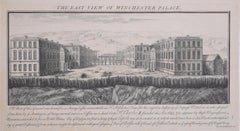
- Winchester Palace, Southwark, London engraving after Samuel and Nathaniel BuckBy Samuel & Nathaniel BuckLocated in London, GBTo see more, scroll down to "More from this Seller" and below it click on "See all from this Seller." after Samuel Buck (1696 - 1779) and Nathaniel Buck (active 1724 - 1759) The East View of Winchester Palace (1733) Engraving 20 x 37 cm An engraved view of Winchester Palace, a bishop's palace built in the 12th century. It served as the London townhouse of the Bishops of Winchester and remained in use until around 1700, when it was divided up into tenements and warehouses. The building was largely destroyed by fire in 1814. Samuel and Nathaniel Buck...Category
1730s Landscape Prints
MaterialsEngraving
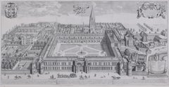
- Christ Church, Oxford 1675 engraving by David LogganBy David LogganLocated in London, GBTo see our other views of Oxford and Cambridge, scroll down to "More from this Seller" and below it click on "See all from this seller" - or send us a message if you cannot find the ...Category
1670s Realist Landscape Prints
MaterialsEngraving
- Cambridgeshire map 17th century engraving by John SpeedBy John SpeedLocated in London, GBTo see more, scroll down to "More from this Seller" and below it click on "See all from this Seller." John Speed (1551 or 1552 - 1629) Map of Cambridgeshire Engraving with later hand colouring 39 x 53 cm A beautifully coloured map of Cambridgeshire, with an antique description...Category
1610s Landscape Prints
MaterialsEngraving
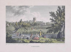
- Oxford 18th century engraving after Edward DayesLocated in London, GBTo see our other views of Oxford and Cambridge, scroll down to "More from this Seller" and below it click on "See all from this Seller" - or send us a message if you cannot find the ...Category
1790s Landscape Prints
MaterialsEngraving
- Map of Oxfordshire coloured 18th century engraving by Thomas KitchinBy Thomas KitchinLocated in London, GBTo see our other original maps, scroll down to "More from this Seller" and below it click on "See all from this Seller" - or send us a message if you cannot find the poster you want....Category
1760s Landscape Prints
MaterialsEngraving


You May Also Like
- L'Isle de France: A Hand-colored 17th Century Map by De WitBy Frederick de WitLocated in Alamo, CAThis colorful and detailed 17th century hand-colored copperplate map by Frederick De Wit was published in Amsterdam between 1666 and 1760. The map depicts the Île-de-France, which is one of the ancient provinces of France. Paris is located in the center of the map, with Versailles to the southwest The map extends from Rouen in the west to Reims in the east. The area around Paris, the Véxin Français, was the original domain of the king of France. Other areas were ruled by French feudal lords. For example, the Véxin Normand area was the domain of the Duke of Normandy...Category
Early 18th Century Old Masters More Prints
MaterialsEngraving
- Map of the Russian Empire: An Original 18th Century Hand-colored Map by E. BowenLocated in Alamo, CAThis is an original 18th century hand-colored map entitled "A New & Accurate Map of The Whole Russian Empire, As Contain'd Both In Europe and Asia, Drawn from Authentic Journals, Sur...Category
Mid-18th Century Old Masters Landscape Prints
MaterialsEngraving
- View of Emden, Germany: A 16th Century Hand-colored Map by Braun & HogenbergBy Franz HogenbergLocated in Alamo, CAThis is a 16th century original hand-colored copperplate engraved map of a bird's-eye View of Embden, Germany entitled " Emuda, vulgo Embden vrbs Frisia orientalis primaria" by Georg Braun & Franz Hogenberg, in volume II of their famous city atlas "Civitates Orbis Terrarum", published in Cologne, Germany in 1575. This is a beautifully colored and detailed map of Emden, a seaport in northwestern Germany, along the Ems River and perhaps portions of over Dollart Bay, near the border with the Netherland. The map depicts a bird's-eye view of the city from the southwest, as well as a view of the harbor and an extensive system of canals. Numerous ships of various sizes, as well as two rowboats containing numerous occupants are seen in the main waterway in the foreground and additional boats line two canals in the center of the city. Two men and two women are shown on a hill in the foreground on the right, dressed in the 16th century style of nobility. Two ornate crests are included in each corner. A title strap-work cartouche is in the upper center with the title in Latin. The crest on the right including Engelke up de Muer (The Little Angel on the Wall) was granted by Emperor Maximilian I in 1495. This is an English translation of an excerpt of Braun's description of Embden: "In Emden, the capital of East Frisia, rich merchants live in very fine houses. The city has a broad and well-situated harbour, which in my opinion is unique in Holland. Frisia and the whole of the Netherlands, for the ships can anchor here right under the city walls. They have also extended the harbour as far as the New Town, so that up to 400 ships can now find shelter here when the sea is rough." The emphasis on the harbor and waterways within the city highlights the importance of Emden's place as a seaport at this time. Embden developed from a Dutch/Flemish trading settlement in the 7th-8th centuries into a city as late as late 14th century. In 1494 it was granted staple rights, and in 1536 the harbour was extended. In the mid-16th century Emden's port was thought to have the most ships in Europe. Its population then was about 5,000, rising to 15,000 by the end of the 16th century. The Ems River flowed directly under the city walls, but its course was changed in the 17th century by the construction of a canal. Emden has canals within its city limits, a typical feature of Dutch towns, which also enabled the extension of the harbor. In 1744 Emden was annexed by Prussia and is now part of Germany. It was captured by French forces in 1757 during the Seven Years' War, but recaptured by Anglo-German forces in 1758. During the Napoleonic French era, Emden and the surrounding lands of East Frisia were part of the short-lived Kingdom of Holland. References:Van der Krogt 4, 1230, State 2; Taschen, Braun and Hogenberg...Category
16th Century Old Masters Landscape Prints
MaterialsEngraving
- Ireland: A Framed 17th Century Hand-colored Map by Jan JannsonBy Johannes JanssoniusLocated in Alamo, CAThis is a 17th century hand-colored map entitled "Hibernia Regnum Vulgo Ireland" by Johannes Janssonius's (Jan Jansson), published in Amsterdam in 1640. This highly detailed map depicts the Emerald Isle with an extensive display of towns, roads, mountains, rivers, lakes and county borders, etc. It includes two decorative cartouches on the left. The title cartouche includes the Irish harp and the second, in the upper left, includes a lion wearing a crown on the left, a unicorn on the right and a coat-of-arms in the middle, which includes another Irish harp. A distance scale is seen in the lower right, augmented with two putti. The map is embellished with three sailing ships and a sea monster. Western portions of Scotland and England...Category
Mid-17th Century Old Masters Landscape Prints
MaterialsEngraving
- View of Meissen, Germany: A 16th Century Hand-colored Map by Braun & HogenbergBy Franz HogenbergLocated in Alamo, CAThis is a 16th century original hand-colored copperplate engraved map of View of View of Meissen, Germany entitled "Misena Hermun Duvorum Urbs" by Georg Braun & Franz Hogenberg, from their famous city atlas "Civitates Orbis Terrarum", published in Cologne, Germany in 1575. The map depicts a side view and bird's-eye view, looking across the Elbe River (labelled Albis Fluvius on the map; White River in Latin) from the northeast. In the foreground are three women in conversation on a hill above the city, along with a man and a woman in conversation by a road, all dressed in contemporary costumes of the upper class. A coat-of-arms is present in each upper corner. A great castle sits atop a hill in the background on the left. Meissen grew up around Albrechtsburg castle, built by Emperor Henry I around AD 929, and was granted a municipal charter at the end of the 12th century. From 1471 onwards, the castle complex was reconstructed as the residence of the Saxon electors on the northeast corner of the Domberg (Cathedral Hill). Meissen cathedral is a Gothic hall church begun c. 1270; in 1413 a bolt of lightning destroyed its west towers, which were replaced only in the 20th century. Meissen lies to the northwest of Dresden, Germany in Saxony. Meissen is famous for its Meissen porcelain and the Albrechtsburg castle The following is an English translation of an excerpt from Braun's description of the city: "This city is surrounded by very many rivers, to the east flows the Elbe, to the south the Triebisch, to the west are the mountains, to the north the Meisse, after which the city is said to be named. The city is well-situated in its surroundings, the navigable rivers, the mountains and the healthy air. Around the city there is a good land to grow grain, fertile vineyards on the hillsides and without doubt the mountains are not without ore, for one mile away, up the Elbe, is Scharfenberg, where silver and lead ore are mined.." References: Van der Krogt 4, 2684; Taschen, Braun and Hogenberg...Category
16th Century Old Masters Landscape Prints
MaterialsEngraving
- View of Seravalle, Italy: A 16th Century Hand-colored Map by Braun & HogenbergBy Franz HogenbergLocated in Alamo, CAThis is an original 16th century copperplate originally hand-colored engraved map of View of Seravalle, Italy entitled "Seravallum Celeberrimum Marchiae Tarvisiniae in Agro Foro Juliensi Opp. - Seravalli, quam vides, Spectator, iconem, operi huic nostro suis sumptib. . . ." by Georg Braun & Franz Hogenberg, from their famous city atlas "Civitates Orbis Terrarum", published in Augsberg, Germany in 1575. The map depicts a view of Seravalle, now Vittorio Veneto, in San Marino, Italy, north of Venice, in a topographically accurate bird's-eye view from the south. A water-filled moat is seen to the south of the city walls and farmland to the east. Two men are depicted standing on a hill in the lower right in conversation next to grain sacks and a grazing horse, while a younger man behind them to the right herds a mule carrying presumably pigs. A very colorful and ornate title cartouche is in the upper center and coat-of-arms are in the right and left upper corners. Serravalle lies in an idyllic setting in the foothills and surrounded by orchards. St Mary's Cathedral with its tall bell tower is prominent in the center of the town. The marketplace and town hall with a bell tower in the square are depicted. Houses and shops are around the main square. Serravalle's importance as an agricultural centre is emphasized by the figures in the foreground. In 1337 Serravalle was conquered by the Republic of Venice. In 1866 the town was united with neighbouring Ceneda to form the town of Vittorio Veneto. The following is an English translation of an excerpt from the French description of the city on the back of the map: "Serravalle, a market town renowned for cloth, wine and grain, is in such a beautiful situation that the number of its inhabitants, attracted by the loveliness of the place, has grown so much at times that the wall encircling it has had to be enlarged for the third time. The city with the surrounding town once belonged to the Church in Ceneda as an imperial fief. It subsequently became the seat of the Da Camino family (a princely house that at that time was one of the five most noble in all Italy). Now the city is under the sway of the Venetians but is prudently governed by them. For they send only one city councillor with instructions to ensure that justice prevails and to collect duties. In all else, power lies in the hands of the noble families." This is a translation of the Latin in the title cartouche on the front: "The picture of the town of Serravalle, which you see, viewer, has been contributed to our work entirely at his own expense by Minutius, son of Hieronymus Minutius, a noble gentleman and one renowned for the far-reaching competence of his jurisdiction. We saw him sojourning in Cologne, where he was on business for Gregory XIII; while our good wishes accompany him, we should also like to accompany him on his way with this remembrance, even though it might be against his will, so that even those who have not seen him may learn of his excellence. However, those who do not yet know him will also see his excellence if God the Almighthy does not summon erring souls too soon back to the eternal seat of the Blessed." References: Van der Krogt 4, 4728, State 1; Taschen, Braun and Hogenberg, p.331; Fauser, #14960 This striking hand-colored city view is printed on laid, chain-linked paper with wide margins. The sheet measures 16" high by 21" wide. There is a central vertical fold as issued and French text on the verso, with Latin on the front. There is some discoloration in the upper and right margins which may represent some watercolor paint from the time of the original hand-coloring of the map. There is a small hole to the right of the upper portion of the vertical fold, which is only visible when held up to light and an area of reinforcement on the verso of the lower vertical fold. The map is otherwise in very good to excellent condition. Braun and Hogenberg's 'The Civitates Orbis Terrarum' was the second atlas of maps ever published and the first atlas of cities and towns of the world. It is one of the most important books published in the 16th century. Most of the maps in the atlas were engraved by Franz Hogenberg and the text, with its descriptions of the history and additional factual information of the cities, was written by a team of writers and edited by Georg Braun. The work contained 546 bird-eye views and map views of cities and towns from all over the world. It gave graphic representation of the main features of the illustrated cities and towns, including the buildings and streets. Although the ordinary buildings are stylized, the principal buildings are reproduced from actual drawings created on location. The principal landmarks and streets can still be recognized today. In addition, the maps often include the heraldic arms of the city, the nature of the surrounding countryside, the important rivers, streams and harbors, even depicting stone bridges, wooden pontoons, flat-bottomed ferries, ships and working boats, wharves and jetties, as well as land-based activities, including horsemen, pedestrians, wagons, coaches, and palanquins. Small vignettes are often included which illustrate the trade, occupations and habits of the local inhabitants, such as agriculture, paper-making and textiles, as well as local forms of punishment, such as gibbets, wheels, floggings etc. Large figures dressed in their local costume are often presented out of proportion in the foreground. The aim of the authors was to give as much information as possible in a pleasing visual form. They succeeded in creating maps that were both informative and decorative works of art. The atlas is a wonderful glimpse of life in medieval Europe. Georg Braun (1541-1622) was German Catholic...Category
16th Century Old Masters Landscape Prints
MaterialsEngraving


Recently Viewed
View AllMore Ways To Browse
Cherub Click
Segregation Sign
Luigi Kasimir San Francisco
Set Of 6 Architectural Prints
Women In Uniform Art
Andy Warhol Art Signed Mick
Rembrandt Etching Beggar With A Wooden Leg
Medieval Woman
The Last Works Of Henri Matisse
Maurice Paradise
Aegyptus Antiqua
Charles Hanlon
Edo Trestle
Helen Beard
French Large Salon Table
Hand Painted Austrian Screen
Stark Sailboat
Library Book Display