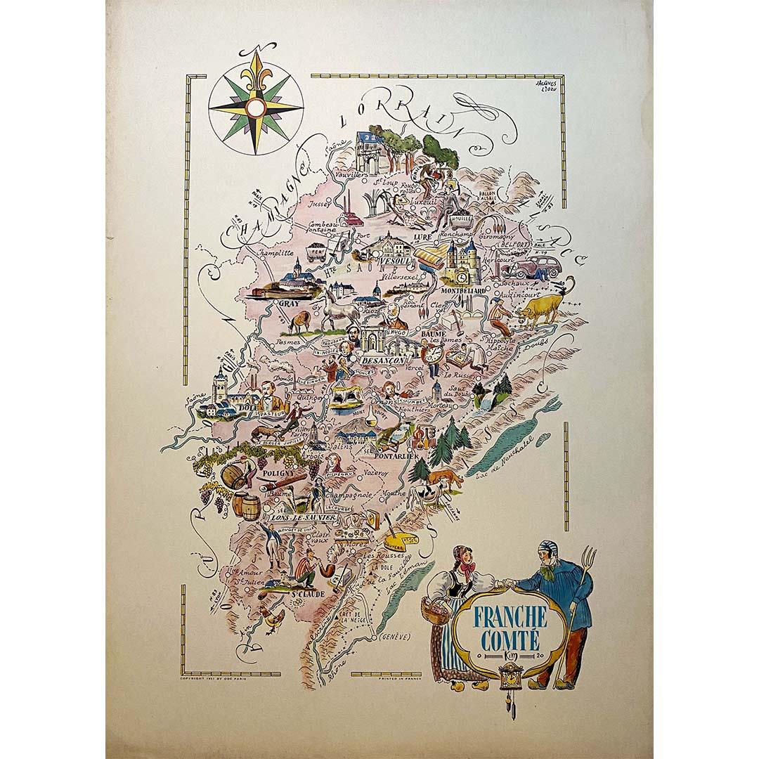
Items Similar to Jacques Liozu's 1951 illustrated map of Alsace and Lorraine in France


Want more images or videos?
Request additional images or videos from the seller
1 of 9
Jacques LiozuJacques Liozu's 1951 illustrated map of Alsace and Lorraine in France1951
1951
$835.04
£617.35
€700
CA$1,148.58
A$1,276.72
CHF 669.23
MX$15,591.84
NOK 8,354.94
SEK 7,860.44
DKK 5,329.09
About the Item
Jacques Liozu's 1951 illustrated map of Alsace and Lorraine is a remarkable work of cartography that blends art and geography to offer a poetic and moving vision of these emblematic regions of France. Jacques Liozu, the renowned French artist-cartographer, created this map with an attention to detail and artistic sensitivity that testify to his exceptional talent.
The map's illustration is a veritable ode to Alsace and Lorraine. Liozu has used delicate colors and artistic motifs to depict the Vosges mountains, winding rivers and historic towns of these two regions. Each element is carefully designed to capture the essence of their cultural and natural heritage.
This map goes far beyond its practical function of providing geographical information. It offers a moving and evocative representation of Alsace and Lorraine, inviting the viewer to discover their unique charm and rich history.
Today, Jacques Liozu's illustrated map of Alsace and Lorraine has become a sought-after collector's item for cartography enthusiasts and art lovers alike. It testifies to Liozu's artistic talent and his ability to transform a geographical map into a sensitive and moving work of art. The map continues to inspire admiration and affection for the regions that have shaped France's history and identity. It also serves as a reminder of the importance of art in our understanding and appreciation of the places we hold dear.
Alsace - Map - Lorraine
Odé Paris
- Creator:Jacques Liozu (1910 - 1974, French)
- Creation Year:1951
- Dimensions:Height: 22.05 in (56 cm)Width: 16.15 in (41 cm)
- Medium:
- Period:
- Condition:Very good condition.
- Gallery Location:PARIS, FR
- Reference Number:1stDibs: LU1792212726172
About the Seller
5.0
Gold Seller
Premium sellers maintaining a 4.3+ rating and 24-hour response times
Established in 2021
1stDibs seller since 2022
171 sales on 1stDibs
Typical response time: 1 hour
- ShippingRetrieving quote...Shipping from: PARIS, France
- Return Policy
Authenticity Guarantee
In the unlikely event there’s an issue with an item’s authenticity, contact us within 1 year for a full refund. DetailsMoney-Back Guarantee
If your item is not as described, is damaged in transit, or does not arrive, contact us within 7 days for a full refund. Details24-Hour Cancellation
You have a 24-hour grace period in which to reconsider your purchase, with no questions asked.Vetted Professional Sellers
Our world-class sellers must adhere to strict standards for service and quality, maintaining the integrity of our listings.Price-Match Guarantee
If you find that a seller listed the same item for a lower price elsewhere, we’ll match it.Trusted Global Delivery
Our best-in-class carrier network provides specialized shipping options worldwide, including custom delivery.More From This Seller
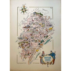
View AllJacques Liozu's 1951 illustrated map of the region of Franche-Comté
By Jacques Liozu
Located in PARIS, FR
Jacques Liozu's 1951 illustrated map of Franche-Comté is a cartographic work of great beauty and precision. Jacques Liozu, a renowned French artist and cartographer, created this map...
Category
1950s Prints and Multiples
Materials
Lithograph, Paper
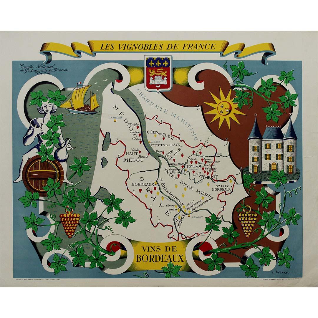
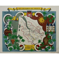
Stunning illustrated wine map by French artist Rémy Hétreau in the 1950s
Located in PARIS, FR
This stunning illustrated wine map, created by French artist Rémy Hétreau in the 1950s, is a beautifully detailed tribute to the legendary Bordeaux wine region. Commissioned by the Comité National de Propagande en Faveur du Vin, the poster is both an artistic masterpiece and an educational tool, showcasing the vineyards, terroirs, and appellations that define Bordeaux’s winemaking heritage.
At the center of the composition, a finely drawn map of Bordeaux highlights its most famous wine-growing areas, including:
🍷 Médoc – Home to prestigious wines from Pauillac, Margaux, and Saint-Estèphe.
🍷 Saint-Émilion & Pomerol – Renowned for their rich, elegant reds.
🍷 Graves & Sauternes – The birthplace of world-famous sweet wines.
🍷 Entre-Deux-Mers – Known for its crisp white wines.
Surrounding the map is a whimsical, decorative border featuring grapevines, a château, a sunlit vineyard, and a sailing ship, reflecting Bordeaux’s rich viticultural history and its connection to trade and maritime commerce. The Bordeaux coat of arms sits proudly at the top, reinforcing the region’s centuries-old winemaking tradition.
Rémy Hétreau (1913–2001), a celebrated French illustrator and designer, was known for his elegant, hand-drawn maps that brought the cultural and geographic identity of France to life. His work on this poster captures the romance, craftsmanship, and prestige of Bordeaux’s wine industry in a timeless mid-century style.
Today, this vintage wine map is highly sought after by collectors of French wine memorabilia...
Category
1950s Prints and Multiples
Materials
Paper, Lithograph
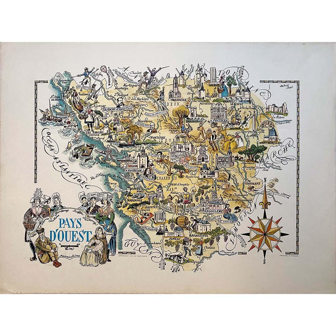
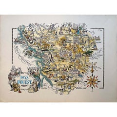
Jacques Liozu's 1951 illustrated map of the region of Pays d'Ouest
By Jacques Liozu
Located in PARIS, FR
Jacques Liozu's 1951 illustrated map of the Pays d'Ouest is a remarkable cartographic work that skilfully combines art and geography. Jacques Liozu, the famous French artist-cartogra...
Category
1950s Prints and Multiples
Materials
Lithograph, Paper
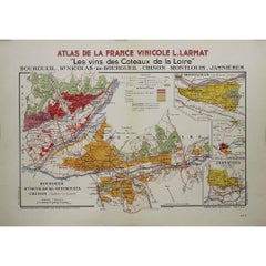
1946 original map "Les vins des côteaux de la Loire - Bourgueil" by Larmat
Located in PARIS, FR
The 1946 original map Atlas de la France Vinicole - Les Vins des Côteaux de la Loire: Bourgueil, St Nicolas-de-Bourgueil, Chinon, Montlouis, Jasnières, created by Louis Larmat and pr...
Category
1940s Prints and Multiples
Materials
Lithograph, Paper
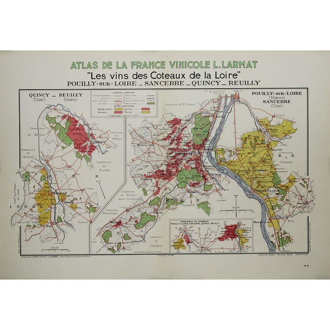
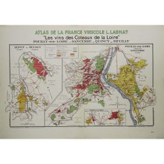
1946 original map "Les vins des côteaux de la Loire - Pouilly-sur-Loire" Larmat
Located in PARIS, FR
The 1946 original map Atlas de la France Vinicole - Les Vins des Côteaux de la Loire: Pouilly-sur-Loire, Sancerre, Quincy, Reuilly, created by Louis Larmat and printed by Dorel in Pa...
Category
1940s Prints and Multiples
Materials
Lithograph, Paper
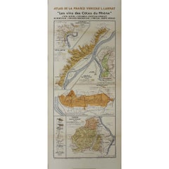
1943 original map "Les vins des Côtes du Rhône" by Larmat
Located in PARIS, FR
The 1943 original map by L. Larmat, titled "Les vins des Côtes du Rhône", is part of the comprehensive "Atlas de la France Vinicole" series, which meticulously charts France’s most r...
Category
1940s Prints and Multiples
Materials
Lithograph, Paper
You May Also Like
Original Vintage Poster Vignobles De France Vins Du Val De Loire Valley Wine Map
Located in London, GB
Original vintage drink advertising poster promoting French wines (one of a series issued by the Comite National de Propagande en Faveur du Vin national committee for the promotion of...
Category
Vintage 1950s French Posters
Materials
Paper
Original Vintage Poster Vignobles De France Vins De Bourgogne Burgundy Wine Map
Located in London, GB
Original vintage drink advertising poster promoting French wines (one of a series issued by the Comite National de Propagande en Faveur du Vin national committee for the promotion of...
Category
Vintage 1950s French Posters
Materials
Paper
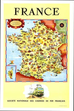
Original Societe Nationale des Chemin Map France, 1953 vintage poster on linen
Located in Spokane, WA
Original French vintage travel poster: "FRANCE, Société Nationale des Chemins de Fer Français." Printed in France by the French National Railroads. Original linen-backed poster; read...
Category
1950s American Modern Landscape Prints
Materials
Lithograph
Map of Aisne France with Soissons and Champagne Vineyards by Vuillemin, 19th c
Located in Langweer, NL
Map of Aisne France with Soissons and Champagne Vineyards by Vuillemin, 19th c
Description:
This richly detailed 19th-century engraved and hand-colored map of the department of Aisn...
Category
Antique Mid-19th Century French Maps
Materials
Paper

Antique Map of France by Johnston (1909)
Located in Langweer, NL
Antique map titled 'France'. Original antique map of France. With inset maps of France in provinces, part of the Riviera and Corsica. This map or...
Category
Early 20th Century Maps
Materials
Paper

$238 Sale Price
20% Off
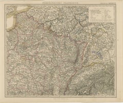
Antique Map of Northeastern France – Alsace, Lorraine & Champagne, 1858
Located in Langweer, NL
Antique Map of Northeastern France – Alsace, Lorraine & Champagne, 1858
Detailed 19th-century engraved map titled "Nordöstliches Frankreich", drawn by Friedrich von Stülpnagel and p...
Category
Antique Mid-19th Century German Maps
Materials
Paper
More Ways To Browse
Illustrated Map
Alsace French
Alsace Art
George Rodrigue Blue Dog Signed
Ballet Russe Costume
Erotic Illustration
German Expressionist Poster
Hiroshige Woodcuts
Imaginations And Objects Of The Future
Lam Wifredo
Marc Chagall Pencil Signed
Pablo Picasso Ceramic Plates
Roy Lichtenstein Signed Lithograph
Van Dyck Etching
Violin Print
Alexander Calder 1969 Lithograph
Green River Project
Retro Pop Machine