Items Similar to Original map of the Belgian Congo illustrated by James Thiriar in 1954


Want more images or videos?
Request additional images or videos from the seller
1 of 8
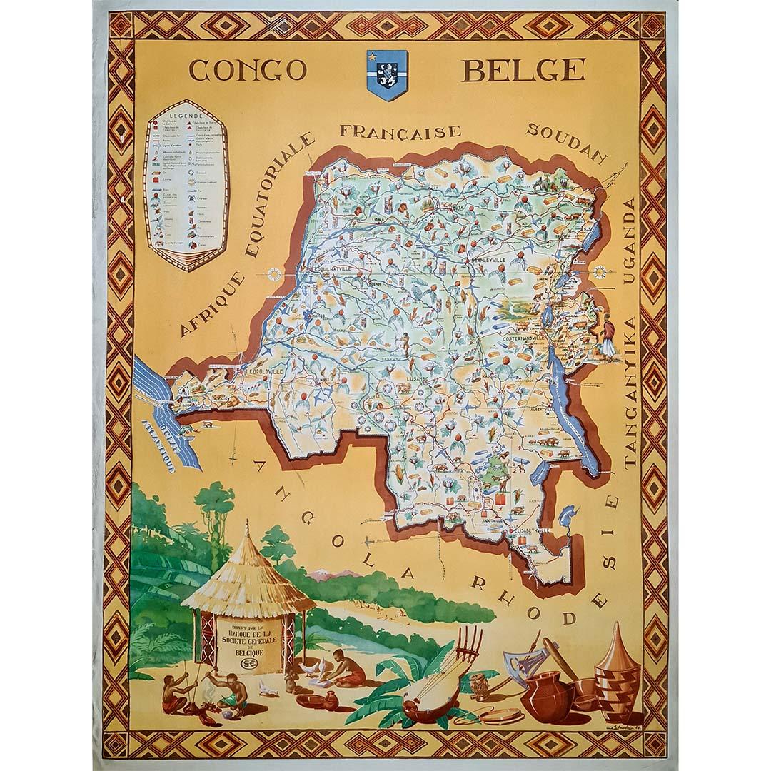
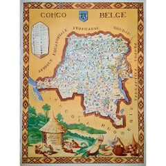
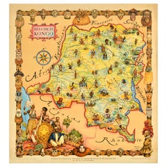
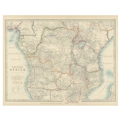
James ThiriarOriginal map of the Belgian Congo illustrated by James Thiriar in 19541954
1954
$1,774.27
£1,339.89
€1,500
CA$2,481.40
A$2,714.19
CHF 1,424.34
MX$32,460.25
NOK 17,975.12
SEK 16,768.62
DKK 11,426.29
About the Item
Beautiful map of the Belgian Congo illustrated by James Thiriar in 1954. James Thiriar, born in Ixelles in 1889 and died in Brussels in 1965, was a Belgian draftsman, illustrator, painter and costume designer, known mainly for his drawings of military uniforms.
Map - Colony - Africa
Congo - Ruanda - Urundi
A. Beyaert Courtrai
- Creator:James Thiriar
- Creation Year:1954
- Dimensions:Height: 31.5 in (80 cm)Width: 29.93 in (76 cm)
- Medium:
- Period:
- Condition:Good condition, on linen.
- Gallery Location:PARIS, FR
- Reference Number:1stDibs: LU1792211162162
About the Seller
5.0
Gold Seller
Premium sellers maintaining a 4.3+ rating and 24-hour response times
Established in 2021
1stDibs seller since 2022
193 sales on 1stDibs
Typical response time: 3 hours
- ShippingRetrieving quote...Shipping from: PARIS, France
- Return Policy
More From This Seller
View All1949 original map of Belgian Congo - Belgian Ministry of Colonies
Located in PARIS, FR
This 1949 original poster titled Congo Belge, created by French illustrator Laboulais, offers a striking example of mid-20th-century colonial-era educational and promotional art. Pub...
Category
1940s Prints and Multiples
Materials
Paper, Lithograph, Linen
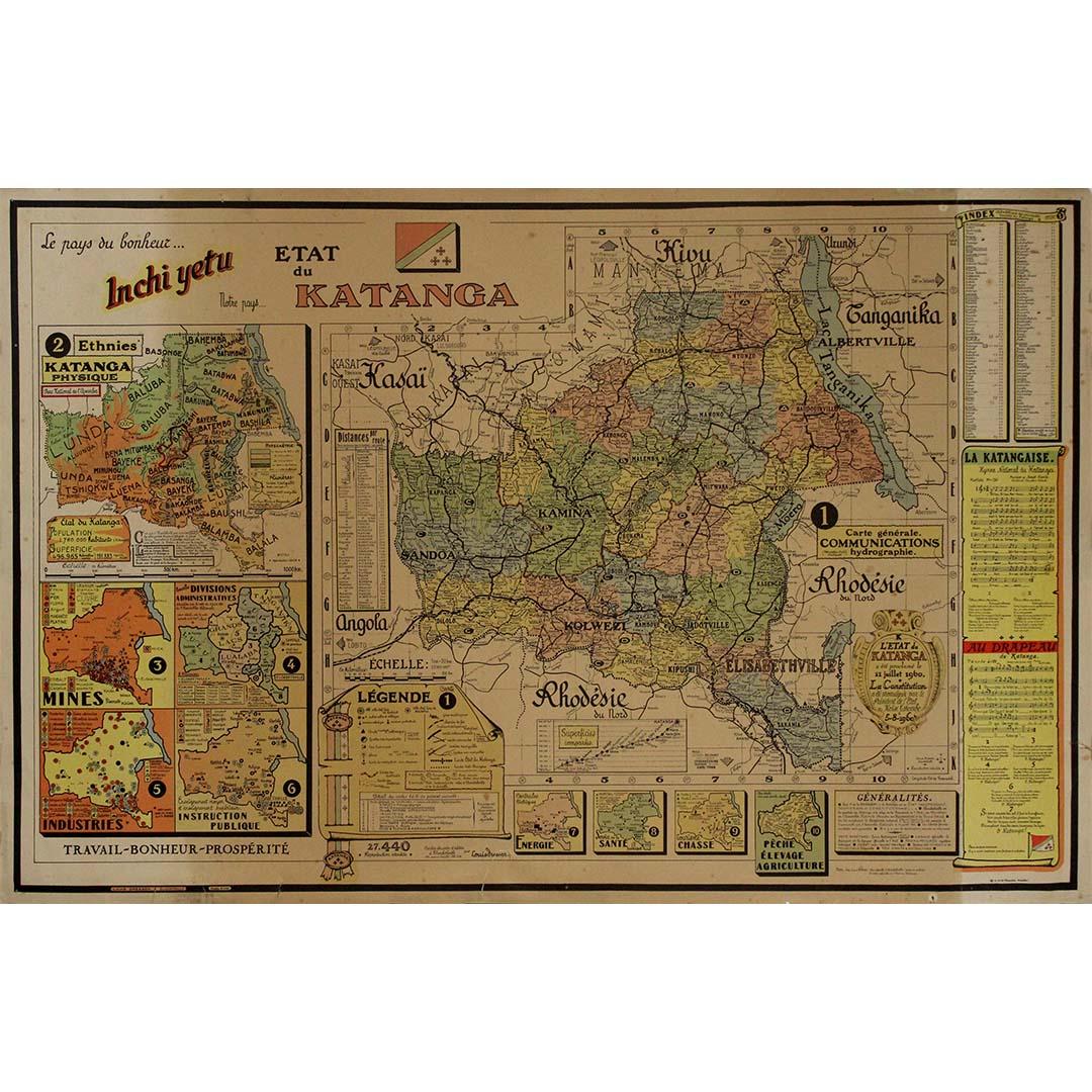
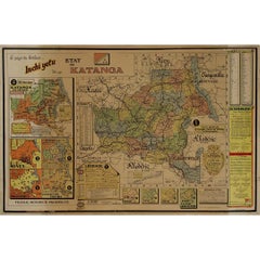
Original 1960 Map by Louis Dressen État du Katanga Congo
Located in PARIS, FR
This original 1960 poster by Louis Dressen, titled État du Katanga, is a rare and powerful visual document from one of the most turbulent moments in post-colonial African history. Pu...
Category
1960s Prints and Multiples
Materials
Paper, Lithograph
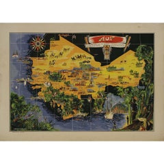
Original map poster by G. Carriat Rolant for AOF (Afrique Occidentale Française)
Located in PARIS, FR
The circa 1950 original map poster by G. Carriat Rolant for AOF (Afrique Occidentale Française) is a notable example of mid-20th-century cartographic art and colonial-era representation. Numbered 584 out of 1000, this limited-edition piece was edited by Paul Bory...
Category
1950s Prints and Multiples
Materials
Paper, Lithograph
Jacques Liozu's 1951 illustrated map of South America
By Jacques Liozu
Located in PARIS, FR
Jacques Liozu's 1951 illustrated map of South America is an exceptional work of cartography that skilfully blends art and geography. French artist and cartographer Jacques Liozu crea...
Category
1950s Prints and Multiples
Materials
Paper, Lithograph

1947 original map Gouvernement Généraux du Poitou, du Pays d'Aunis
Located in PARIS, FR
The 1947 original map Gouvernement Généraux du Poitou, du Pays d'Aunis et de Saintonge Angoumois, created by Louis Larmat and printed by Dorel in Paris, is a beautifully detailed cartographic representation of a historically significant region in western France. This map, part of Larmat’s extensive body of work, is known for its artistic craftsmanship and geographical precision, offering a comprehensive view of the historical administrative regions of Poitou, Aunis, Saintonge, and Angoumois, which played key roles in the political and cultural history of France.
Louis Larmat is celebrated for his contributions to cartography, particularly for his ability to merge historical context, topographical detail, and aesthetic elegance in his maps. His works, especially those focusing on the vinicultural regions of France, are highly respected for their accuracy and artistry. This particular map, although focusing on a more political and historical aspect rather than the wine regions he is most famous for, continues his tradition of detailed regional documentation. Larmat’s cartographic works often transcended the realm of simple geographical depiction, becoming historical documents that encapsulate the cultural essence of the regions they portray.
This map illustrates the general governments (administrative divisions) of the provinces of Poitou, Aunis, Saintonge, and Angoumois, regions that are steeped in history. These areas, situated along France’s western coastline, have been integral to the country’s political, economic, and cultural development over centuries. The region of Poitou, for example, is historically known as the birthplace of Eleanor of Aquitaine...
Category
1940s Prints and Multiples
Materials
Paper, Lithograph

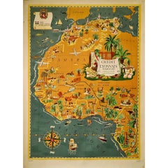
1939 original map Lucien Boucher Crédit Lyonnais Afrique Du Nord Union Française
By Lucien Boucher
Located in PARIS, FR
The 1939 original map by Lucien Boucher, commissioned by Crédit Lyonnais, is a remarkable piece of cartographic art that highlights the regions of North Africa within the French Unio...
Category
1930s Prints and Multiples
Materials
Paper, Lithograph
You May Also Like
Original Vintage Travel Map Poster Belgian Congo Africa Thiriar Margraff Belgium
Located in London, GB
Original vintage travel map poster for the Belgian Congo / Belgisch Kongo featuring a pictorial map of the area bordering Equatorial Africa, French Sudan, ...
Category
Vintage 1940s Belgian Posters
Materials
Paper
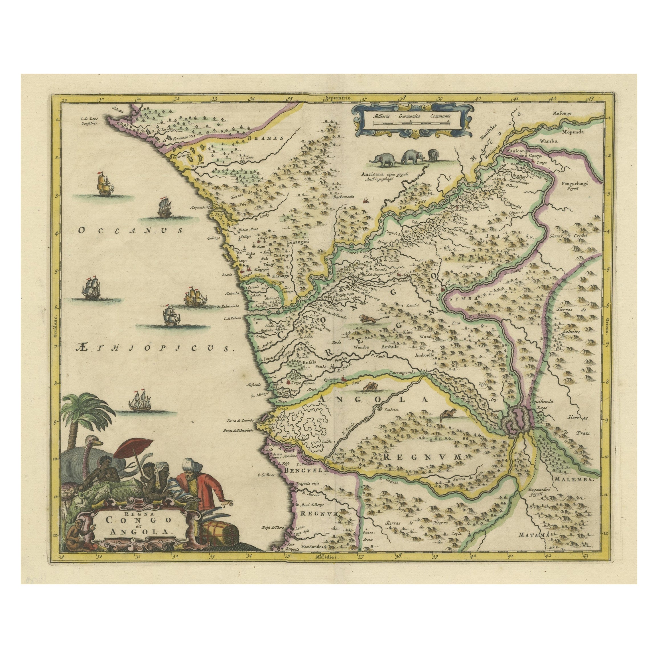
Antique Map of West Africa, focused on the Congo and Angola
Located in Langweer, NL
Original antique map titled 'Regna Congo et Angola'. Decorative 17th Century English map of a portion of West Africa, focused on the Congo and Angola. The map is centered on the Zair...
Category
Antique Late 17th Century Maps
Materials
Paper
$804 Sale Price
20% Off
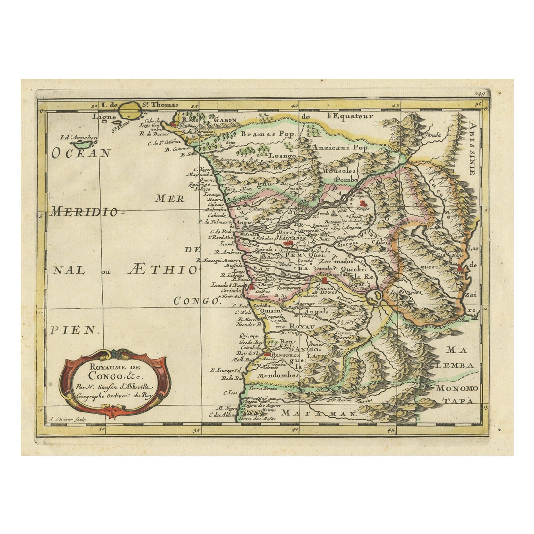
Antique Map of Gabon, Angola and the Congo Region in Africa c.1680
Located in Langweer, NL
Antique map titled 'Royaume de Congo'.
Map of Gabon, the Congo and Angola from Cape Lopez and Sao Tomé to approximately the border with present-day Namibia. The map is fully engrav...
Category
Antique 17th Century Maps
Materials
Paper
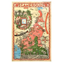
Original Vintage Illustrated Map Poster Afrique Equatoriale Francaise Cameroon
Located in London, GB
Original vintage illustrated map poster for Cameroun AOF Afrique Occidentale Francaise / Cameroon French West Africa showing the Central African country of ...
Category
Vintage 1950s French Posters
Materials
Paper
Antique Map of Central Africa, 1903, With Colonial Territories Explorers Routes
Located in Langweer, NL
Antique Map of Central Africa, 1903, Featuring Colonial Territories and Explorers’ Routes
This antique map, titled "Central Africa," was engraved and published in 1903 by W. & A.K. ...
Category
Early 20th Century Maps
Materials
Paper
Antique Map of the Congo, Gabon and Angola by N. Sanson, circa 1700
Located in Langweer, NL
Attractive map of Gabon, the Congo and Angola from Cape Lopez and Sao Tomé to approximately the border with present-day Namibia. The map is fully engraved with mountains, rivers, for...
Category
Antique Early 18th Century Dutch Maps
Materials
Paper
More Ways To Browse
Vintage Illustrated Maps
Military Map
Vintage African Map
Kandinsky Composition
Life Size African Wood Sculpture
Micheal Von Zichy
Miro Oiseau
Napoleon Lithograph
Notre Dame De Paris Painting 1950s
Paul Klee Lithograph
Raf Posters
Railroad Poster
Roland Garros Poster
Romantic French Prints
Selling Antique Prints
Shell Posters Vintage
Shunga Prints
Signed Alexander Calder