Items Similar to Basilica di S.Paolo e Moneste - Vintage Offset by Giuseppe Vasi - 18th century


Want more images or videos?
Request additional images or videos from the seller
1 of 5
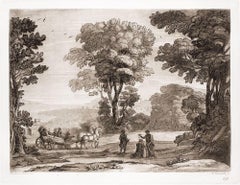
Giuseppe VasiBasilica di S.Paolo e Moneste - Vintage Offset by Giuseppe Vasi - 18th centuryLate 18th century
Late 18th century
About the Item
Basilica di S.Paolo e Monestero de Monici Casinensi is a vintage offset print realized in the early 20th Century after Giuseppe Vasi.
Good conditions.
Giuseppe Vasi (Corleone,1710 - Rome, 1782) was an engraver, architect, and landscape artist. Between 1746 and 1761, Vasi published 10 volumes with 240 engravings of the monuments of Rome. Among his students, there was Giovanni Battista Piranesi. Vasi's goal was to represent the Rome of his time. Vasi studied architecture as well so that he was able to represent the monuments of Rome with precision and in much detail.
- Creator:Giuseppe Vasi (1710 - 1782, Italian)
- Creation Year:Late 18th century
- Dimensions:Height: 13 in (33 cm)Width: 18.12 in (46 cm)Depth: 0.08 in (2 mm)
- Medium:
- Movement & Style:
- Period:
- Framing:Framing Options Available
- Condition:Insurance may be requested by customers as additional service, contact us for more information.
- Gallery Location:Roma, IT
- Reference Number:

Giuseppe Vasi
Giuseppe Vasi (1710-1782) was an Italian engraver and architect, best known for his illustrated 'Vedute Roma Antica' (views of ancient Rome), published from 1746 to 1761. Among his pupils was Giovanni Battista Piranesi. Piranesi worked together with him on the Vedute and some are signed both by Vasi and Piranesi. The two disagreed on the movement during their time to denigrate the work of Baroque architects, such as Bernini and Borromini. Vasi favored the more modern architectural approach approach and Piranesi favored the more classical architecture. They often had extreme disagreements and reportedly Piranesi threatened to kill his teacher.
About the Seller
4.9
Platinum Seller
These expertly vetted sellers are 1stDibs' most experienced sellers and are rated highest by our customers.
1stDibs seller since 2017
6,767 sales on 1stDibs
Typical response time: 3 hours
- ShippingRetrieving quote...Ships From: Monaco, Monaco
- Return PolicyA return for this item may be initiated within 14 days of delivery.
More From This SellerView All
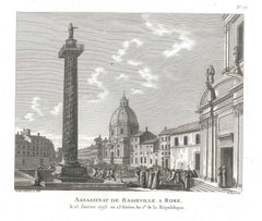
- Assassinat de Basseville à Rome - Original Etching by P.G. Berthault - 1793By Pierre Gabriel BerthaultLocated in Roma, ITAssassinat De Basseville à Rome is an original black and white etching realized by Pierre Gabriel Berthault, after Jacques François Joseph Swebach-Desfontaines in 1793. Title with caption on plate on the lower center: "Assassinat de Basseville, à Rome/ le 13 Janvier 1793, ou 23 Nivose An Ier de la République". Below the image on the lower margin, "Swebach Desfontaines onv. et del. / Berthault sculp." is etched on plate. This modern artwork is numbered "N. 76", because it is from the series Les Tableaux historiques de la Révolution française. As a matter of fact, Pierre-Gabriel Berthault is well-known for having engraved plates from this collection with the collaboration of the engraver Jean Duplessis-Bertaux. A work - hanging in the balance between news and history - with illustrations of salient or minimal events occurred during the French Revolution. As a celebration of the new ideals of brotherhood, justice, and equality, Les Tableaux immediately became a point of reference for journalism at the time. Of traditional cut, namely showing a view with many human figures, the engraving simplified the lines to be immediately readable for the general public. In our specific case, this original print represents the murder of Hugou de Bassville or Basseville (7 February, 1743 – 13 January, 1793), a French journalist and diplomatist, and protector of the radical Jacobins in Rome. In excellent conditions, except for a usual yellowing of the paper on the edges and a light trace of oxidations on the lower and right margins, beyond the marginal line of the matrix. Pierre-Gabriel Berthault (Saint-Maur-des-Fossés, 1737 - Paris, 1831) was a French master who made engravings from drawings by Jean-Claude Richard de Saint-Non (known as the Abbot of Saint-Non) and from paintings by Louis François Cassas. He depicted many views of Italy and created the collections Voyage à Naples and Voyage pittoresque de la Syrie, de la Palestine et de la basse-Egypte. Before the French Revolution, he was famous for being the author of the Vues intérieures de Paris and for tables with architectural elevations.Category
1790s Old Masters Landscape Prints
MaterialsEtching
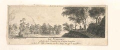
- The Passengers - Original Etching by A. M. de Ghuy - 1775Located in Roma, ITThe Passenger is an original artwork realized by Antoine de Marcenay de Ghuy in 1775. Original etching on paper. Titled on the lower margin at the center. The artwork is glued on ca...Category
1770s Old Masters Landscape Prints
MaterialsEtching
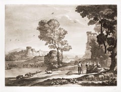
- Liber Veritatis - Original B/W Etching after Claude Lorrain - 1815By Ludovico CaraccioloLocated in Roma, ITImage dimensions: 21 x 27 cm. Liber Veritatis - Plate 95 is a beautiful black and white etching and aquatint on paper realized by the Italian artist Ludovico Caracciolo, after Claud...Category
1810s Old Masters Figurative Prints
MaterialsAquatint, Etching
- Liber Veritatis - Original B/W Etching after Claude Lorrain - 1815By Ludovico CaraccioloLocated in Roma, ITImage dimensions: 21 x 27 cm. Liber Veritatis - Plate 190 is a beautiful black and white etching and aquatint on paper realized by the Italian artist Ludovico Caracciolo, after Clau...Category
1810s Old Masters Figurative Prints
MaterialsAquatint, Etching
- Liber Veritatis - Original B/W Etching after Claude Lorrain - 1815By Ludovico CaraccioloLocated in Roma, ITImage dimensions: 21 x 27 cm. Liber Veritatis - Plate 191 is a beautiful black and white etching and aquatint on paper realized by the Italian artist ...Category
1810s Old Masters Figurative Prints
MaterialsAquatint, Etching
- Liber Veritatis - Original B/W Etching after Claude Lorrain - 1815By Ludovico CaraccioloLocated in Roma, ITImage dimensions: 21 x 27 cm. Liber Veritatis - Plate 176 is a beautiful black and white etching and aquatint on paper realized by the Italian artist ...Category
1810s Old Masters Figurative Prints
MaterialsAquatint, Etching

You May Also Like
- Cartusia Bruxellensis Monastery in Brussels: A 17th C. Hand-colored EngravingBy Lucas Vorsterman the YoungerLocated in Alamo, CAThis is a 17th century hand-colored copperplate engraving entitled "Cartusia Bruxellensis" by Lucas Vorsterman, the Younger, after a drawing by Jacob van Werden or Jacques van Weerden, published in 1659 in Antonius Sanderus' book 'Chorographia sacra Brabantiae sive celebrium aliquot in ea provincia ecclesiarum et coenobiorum descriptio . . . Brussel' (A sacred chorography of Brabant, or a description of several famous churches and convents in that province). It also appeared in other publications by Sanderus. In the 17th century, Brussels was within the Duchy of Brabant. This engraving depicts a bird's-eye view of the Scheut Carthusian Monastery in Brussels. Scheut is a district of Anderlecht, a municipality of Brussels, Belgium. The monastery housed monks, who took a vow of silence, in 20 rooms. There is a central courtyard with trees and shrubs. Monks are depicted strolling along its pathways. The cells for the friars are in the middle the cloister. There are people along the streets in the foreground and to the right of the large, imposing monastery. Some are on horseback, others are walking. In the lower right, what appears to be a dog pulls a small cart containing barrels, possibly of beer or wine. Districts and neighborhoods are labelled in the background, including Scheut, Anderlecht and Ransfort. A very ornate cartouche in the lower left contains Latin and the artist's attribution. Another decorative cartouche in the upper central area contains the title. This beautifully hand-colored and detailed engraving is printed on laid, chain-linked paper with wide, full margins. The sheet measures 17.25" high and 21.25" wide. It has Latin text on the verso. It has a central vertical fold, as issued, which is reinforced on the verso. Two small spots in the lower margin may actually represent drops of watercolor paint used to color the engraving. It is otherwise in very good condition. Antonius Sanderus (1586-1664) was a Flemish Catholic cleric and historian. He was born "Antoon Sanders", but Latinized his name like many writers and scholars of his time. He was the author of several books, including 'Chorographia Sacra Brabantiae', which was illustrated with this engraving. Lucas Vorsterman the Younger (1624-between 1666 & 1676) was a Flemish Baroque engraver and draughtsman. He produced engravings after the work of contemporary painters and for books by Antwerp publishers. Jacob van Werden or Jacques van Weerden (active 1643-1669), was a Flemish draughtsman, cartographer, military engineer and archer who was active in the Habsburg Netherlands. His drawings were used as designs for prints executed by various printmakers. He worked on maps, topographical views, historical scenes, portraits and book illustrations. He had a career as a military engineer and a member of the guard of the Spanish King. He advised on various military engineering projects and was an engineer of the Spanish army...Category
Mid-17th Century Old Masters Landscape Prints
MaterialsEngraving
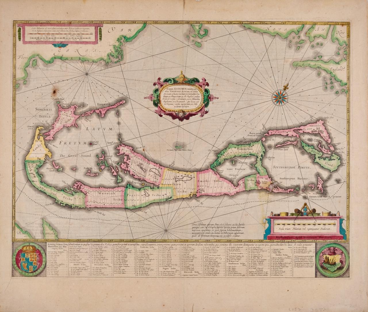
- Bermuda: An Early 17th Century Hand-colored Map by Henricus HondiusBy Henricus HondiusLocated in Alamo, CAThis attractive and interesting map of Bermuda by Henricus Hondius in 1633 is entitled "Mappa Aestivarum Insularum, Alias Barmudas". It is based on a ...Category
Early 17th Century Old Masters Landscape Prints
MaterialsEngraving
- L'Isle de France: A Hand-colored 17th Century Map by De WitBy Frederick de WitLocated in Alamo, CAThis colorful and detailed 17th century hand-colored copperplate map by Frederick De Wit was published in Amsterdam between 1666 and 1760. The map depicts the Île-de-France, which is one of the ancient provinces of France. Paris is located in the center of the map, with Versailles to the southwest The map extends from Rouen in the west to Reims in the east. The area around Paris, the Véxin Français, was the original domain of the king of France. Other areas were ruled by French feudal lords. For example, the Véxin Normand area was the domain of the Duke of Normandy...Category
Early 18th Century Old Masters More Prints
MaterialsEngraving
- Map of the Russian Empire: An Original 18th Century Hand-colored Map by E. BowenLocated in Alamo, CAThis is an original 18th century hand-colored map entitled "A New & Accurate Map of The Whole Russian Empire, As Contain'd Both In Europe and Asia, Drawn from Authentic Journals, Sur...Category
Mid-18th Century Old Masters Landscape Prints
MaterialsEngraving
- View of Emden, Germany: A 16th Century Hand-colored Map by Braun & HogenbergBy Franz HogenbergLocated in Alamo, CAThis is a 16th century original hand-colored copperplate engraved map of a bird's-eye View of Embden, Germany entitled " Emuda, vulgo Embden vrbs Frisia orientalis primaria" by Georg Braun & Franz Hogenberg, in volume II of their famous city atlas "Civitates Orbis Terrarum", published in Cologne, Germany in 1575. This is a beautifully colored and detailed map of Emden, a seaport in northwestern Germany, along the Ems River and perhaps portions of over Dollart Bay, near the border with the Netherland. The map depicts a bird's-eye view of the city from the southwest, as well as a view of the harbor and an extensive system of canals. Numerous ships of various sizes, as well as two rowboats containing numerous occupants are seen in the main waterway in the foreground and additional boats line two canals in the center of the city. Two men and two women are shown on a hill in the foreground on the right, dressed in the 16th century style of nobility. Two ornate crests are included in each corner. A title strap-work cartouche is in the upper center with the title in Latin. The crest on the right including Engelke up de Muer (The Little Angel on the Wall) was granted by Emperor Maximilian I in 1495. This is an English translation of an excerpt of Braun's description of Embden: "In Emden, the capital of East Frisia, rich merchants live in very fine houses. The city has a broad and well-situated harbour, which in my opinion is unique in Holland. Frisia and the whole of the Netherlands, for the ships can anchor here right under the city walls. They have also extended the harbour as far as the New Town, so that up to 400 ships can now find shelter here when the sea is rough." The emphasis on the harbor and waterways within the city highlights the importance of Emden's place as a seaport at this time. Embden developed from a Dutch/Flemish trading settlement in the 7th-8th centuries into a city as late as late 14th century. In 1494 it was granted staple rights, and in 1536 the harbour was extended. In the mid-16th century Emden's port was thought to have the most ships in Europe. Its population then was about 5,000, rising to 15,000 by the end of the 16th century. The Ems River flowed directly under the city walls, but its course was changed in the 17th century by the construction of a canal. Emden has canals within its city limits, a typical feature of Dutch towns, which also enabled the extension of the harbor. In 1744 Emden was annexed by Prussia and is now part of Germany. It was captured by French forces in 1757 during the Seven Years' War, but recaptured by Anglo-German forces in 1758. During the Napoleonic French era, Emden and the surrounding lands of East Frisia were part of the short-lived Kingdom of Holland. References:Van der Krogt 4, 1230, State 2; Taschen, Braun and Hogenberg...Category
16th Century Old Masters Landscape Prints
MaterialsEngraving
- Ireland: A Framed 17th Century Hand-colored Map by Jan JannsonBy Johannes JanssoniusLocated in Alamo, CAThis is a 17th century hand-colored map entitled "Hibernia Regnum Vulgo Ireland" by Johannes Janssonius's (Jan Jansson), published in Amsterdam in 1640. This highly detailed map depicts the Emerald Isle with an extensive display of towns, roads, mountains, rivers, lakes and county borders, etc. It includes two decorative cartouches on the left. The title cartouche includes the Irish harp and the second, in the upper left, includes a lion wearing a crown on the left, a unicorn on the right and a coat-of-arms in the middle, which includes another Irish harp. A distance scale is seen in the lower right, augmented with two putti. The map is embellished with three sailing ships and a sea monster. Western portions of Scotland and England...Category
Mid-17th Century Old Masters Landscape Prints
MaterialsEngraving


Recently Viewed
View AllMore Ways To Browse
Antique Vintage And Old
Master E S
Rome Architecture Prints
Paolo Di Paolo
Piranesi Engraving
Piranesi Architectural
After Giovanni Battista Piranesi
Piranesi Basilica
Sailboat Print
Trees Woodcut Print
Antique Etchings Landscape
Oxford Etching
Liberty Vintage Fabric
Liberty Fabric Vintage
Liberty Vintage Fabrics
Monet Print Framed
Rome Fountain
East Germany 1950