Want more images or videos?
Request additional images or videos from the seller
1 of 10
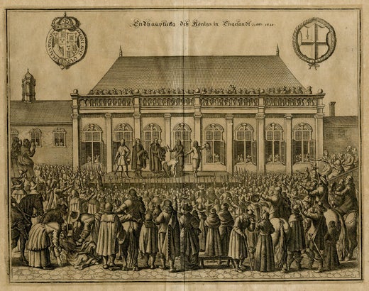
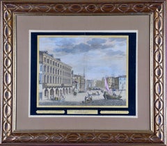
Matthäus Merian the ElderSt. Peter's Square in Basel: 17th Century Engraving by Matthäus Merian1654
1654
$775List Price
About the Item
- Creator:Matthäus Merian the Elder (1593 - 1650, German)
- Creation Year:1654
- Dimensions:Height: 15.25 in (38.74 cm)Width: 19.94 in (50.65 cm)Depth: 0.63 in (1.61 cm)
- Medium:
- Movement & Style:
- Period:1650-1659
- Condition:
- Gallery Location:Alamo, CA
- Reference Number:Seller: #36131stDibs: LU117325384721
Matthäus Merian the Elder
Matthäus Merian is one of the most respected Swiss/German artists and engravers of the 17th century. In addition to creating a large number of illustrations and maps, he passed his knowledge and skill to his children, who followed in the family tradition. His son Matthäus Merian, the Younger was an accomplished engraver. His daughter Maria Sybella Merian in addition to becoming a prominent artist, became one of the greatest woman scientists of the 18th century as an entomologist. Her engravings of insects in their natural habitats are as sought after by collectors as are her father's illustrations.
About the Seller
5.0
Platinum Seller
Premium sellers with a 4.7+ rating and 24-hour response times
Established in 2011
1stDibs seller since 2019
299 sales on 1stDibs
Typical response time: 1 hour
Authenticity Guarantee
In the unlikely event there’s an issue with an item’s authenticity, contact us within 1 year for a full refund. DetailsMoney-Back Guarantee
If your item is not as described, is damaged in transit, or does not arrive, contact us within 7 days for a full refund. Details24-Hour Cancellation
You have a 24-hour grace period in which to reconsider your purchase, with no questions asked.Vetted Professional Sellers
Our world-class sellers must adhere to strict standards for service and quality, maintaining the integrity of our listings.Price-Match Guarantee
If you find that a seller listed the same item for a lower price elsewhere, we’ll match it.Trusted Global Delivery
Our best-in-class carrier network provides specialized shipping options worldwide, including custom delivery.You May Also Like
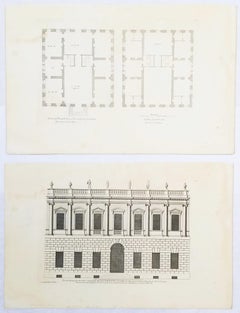
Set of Two Engravings from Campbell's "Vitruvius Britannicus" /// Architecture
By Colen Campbell
Located in Saint Augustine, FL
Artist: Colen Campbell (Scottish, 1676-1729)
Titles: "The Plan of this New Design to the Earl of Islay" (Vol. 1, Plate 53) and "This New Design to the Earl of Islay" (Vol. 1, Plate 5...
Category
1710s Old Masters Landscape Prints
Materials
Laid Paper, Engraving, Etching, Intaglio
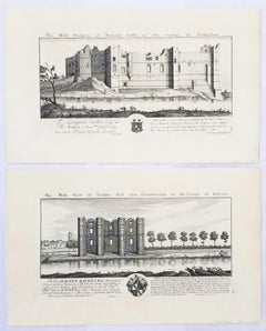
"Torksey Hall" and "Newark Castle" from "Buck's Antiquities" /// Architecture UK
By Samuel & Nathaniel Buck
Located in Saint Augustine, FL
Artist: Samuel and Nathaniel Buck (English, 1696-1779) and (?-1759/1774)
Title: "Torksey Hall" (Plate 179) and "Newark Castle" (Plate 226)
Portfolio: Buck's Antiquities or Venerable ...
Category
1720s Old Masters Landscape Prints
Materials
Laid Paper, Engraving, Intaglio
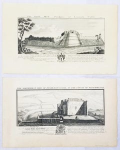
"Pendragon Castle" and "Lincoln Castle" from "Buck's Antiquities" /// British UK
By Samuel & Nathaniel Buck
Located in Saint Augustine, FL
Artist: Samuel and Nathaniel Buck (English, 1696-1779) and (?-1759/1774)
Title: "Pendragon Castle" (Plate 312) and "Lincoln Castle" (Plate 170)
Portfolio: Buck's Antiquities or Vener...
Category
1720s Old Masters Landscape Prints
Materials
Laid Paper, Engraving, Intaglio
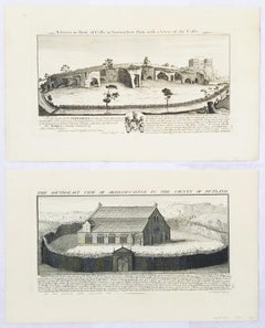
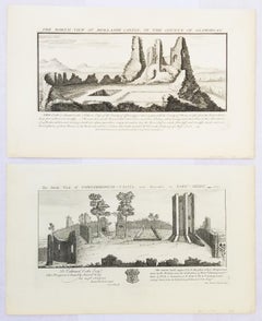
"Oakham Castle" and "Nottingham Park/Castle" from "Buck's Antiquities" /// UK
By Samuel & Nathaniel Buck
Located in Saint Augustine, FL
Artist: Samuel and Nathaniel Buck (English, 1696-1779) and (?-1759/1774)
Title: "Oakham Castle" (Plate 242) and "Nottingham Park/Castle" (Plate 226)
Portfolio: Buck's Antiquities or Venerable Remains of Above 400 Castles, Monasteries, Palaces in England and Wales
Year: 1726-1739
Medium: Set of Two Original Engravings on watermarked laid paper
Limited edition: Unknown
Printer: Unknown
Publisher: Robert Sayer, London, UK
Reference: Lowndes page 303-304; Upcott page 33
Sheet size (each): approx. 11" x 18.25"
Image size (platemark) (each): approx. 7.75" x 14.75"
Condition: "Nottingham Park" has light soiling in margins and scattered light foxmarks across sheet. They are both otherwise strong impressions in very good condition
Notes:
Comes from Samuel and Nathaniel Buck's three volume portfolio "Buck's Antiquities" or "Venerable Remains of Above 400 Castles, Monasteries, Palaces in England and Wales" (1726-1739), which consists of 428 engravings. Both "Oakham Castle" and "Nottingham Park/Castle" have unidentified watermarks in the center of their sheets. They both also have "Liverpool Free Public Library" chop mark/blind stamps at bottom center of their sheets. Old price pencil inscribed in margins.
Oakham Castle is a historic building in Oakham, Rutland. The castle is known for its collection of massive horseshoes and is also recognised as one of the best examples of domestic Norman architecture in England. It is a Grade I listed building. Owned and managed by the Rutland County Council, Oakham Castle is licensed for civil...
Category
1720s Old Masters Landscape Prints
Materials
Laid Paper, Engraving, Intaglio
"St. Martin's Abbey" and "Lady's Chappel" from "Buck's Antiquities" /// British
By Samuel & Nathaniel Buck
Located in Saint Augustine, FL
Artist: Samuel and Nathaniel Buck (English, 1696-1779) and (?-1759/1774)
Title: "St. Martin's Abbey" (Plate 333) and "Lady's Chappel" (Plate 331)
Portfolio: Buck's Antiquities or Venerable Remains of Above 400 Castles, Monasteries, Palaces in England and Wales
Year: 1726-1739
Medium: Set of Two Original Engravings on watermarked laid paper
Limited edition: Unknown
Printer: Unknown
Publisher: Robert Sayer, London, UK
Reference: Lowndes page 303-304; Upcott page 33
Sheet size (each): approx. 11.13" x 18.25"
Image size (platemark) (each): approx. 7.5" x 14.5"
Condition: "St. Martin's Abbey" has a minor crease to upper left corner and repaired edge wear to lower right corner. "Lady's Chappel" has faint toning to sheet and minor soiling in margins. They are both otherwise strong impressions in excellent condition
Notes:
Comes from Samuel and Nathaniel Buck's three volume portfolio "Buck's Antiquities" or "Venerable Remains of Above 400 Castles, Monasteries, Palaces in England and Wales" (1726-1739), which consists of 428 engravings. Both "St. Martin's Abbey" and "Lady's Chappel" have unidentified watermarks in the center of their sheets. They both also have "Liverpool Free Public Library" chop mark/blind stamps at bottom center of their sheets. Old price pencil inscribed in margins.
Saint Martin's Abbey is a community of Roman Catholic Benedictine monks who follow the Rule of St Benedict...
Category
1720s Old Masters Landscape Prints
Materials
Laid Paper, Engraving, Intaglio
$480 Sale Price
20% Off
H 11.13 in W 18.25 in
"Louth Park Abbey" and "Easby Abbey" from "Buck's Antiquities" /// Architecture
By Samuel & Nathaniel Buck
Located in Saint Augustine, FL
Artist: Samuel and Nathaniel Buck (English, 1696-1779) and (?-1759/1774)
Title: "Louth Park Abbey" (Plate 172) and "Easby Abbey" (Plate 324)
Portfolio: Buck's Antiquities or Venerabl...
Category
1720s Old Masters Landscape Prints
Materials
Laid Paper, Engraving, Intaglio
$480 Sale Price
20% Off
H 11.13 in W 18.25 in
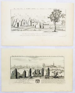
"Moor Tower" and "Kirkham Priory" from "Buck's Antiquities" /// Architecture UK
By Samuel & Nathaniel Buck
Located in Saint Augustine, FL
Artist: Samuel and Nathaniel Buck (English, 1696-1779) and (?-1759/1774)
Title: "Moor Tower" (Plate 173) and "Kirkham Priory" (Plate 328)
Portfolio: Buck's Antiquities or Venerable R...
Category
1720s Old Masters Landscape Prints
Materials
Laid Paper, Engraving, Intaglio

$480 Sale Price
20% Off
H 11.13 in W 18.25 in
"Knaresborough Castle" and "Sawley Abbey" from "Buck's Antiquities" /// British
By Samuel & Nathaniel Buck
Located in Saint Augustine, FL
Artist: Samuel and Nathaniel Buck (English, 1696-1779) and (?-1759/1774)
Title: "Knaresborough Castle" (Plate 330) and "Sawley Abbey" (Plate ...
Category
1720s Old Masters Landscape Prints
Materials
Laid Paper, Engraving, Intaglio
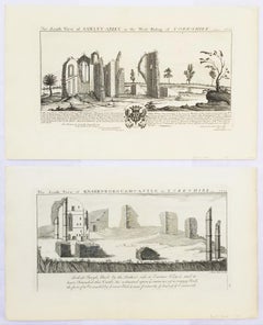
$480 Sale Price
20% Off
H 11.13 in W 18.25 in
"Conisborough Castle" and "Morlashe Castle" from "Buck's Antiquities" /// UK Art
By Samuel & Nathaniel Buck
Located in Saint Augustine, FL
Artist: Samuel and Nathaniel Buck (English, 1696-1779) and (?-1759/1774)
Title: "Conisborough Castle" (Plate 323) and "Morlashe Castle" (Plat...
Category
1720s Old Masters Landscape Prints
Materials
Laid Paper, Engraving, Intaglio
$480 Sale Price
20% Off
H 11.07 in W 18.25 in
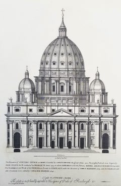
St Peters Church at Rome /// "Vitruvius Britannicus" Architecture Engraving Art
By Colen Campbell
Located in Saint Augustine, FL
Artist: Colen Campbell (Scottish, 1676-1729)
Title: "St Peters Church at Rome" (Vol. 1, Plate 6)
Portfolio: Vitruvius Britannicus; or The British Architect, Containing the Plans, Ele...
Category
1710s Old Masters Landscape Prints
Materials
Laid Paper, Engraving, Etching, Intaglio
More From This Seller
View AllA Hand Colored 17th Century Janssonius Map of Prussia: Poland, N. Germany, etc.
By Johannes Janssonius
Located in Alamo, CA
An attractive hand-colored copperplate engraved 17th century map of Prussia entitled "Prussia Accurate Descripta a Gasparo Henneberg Erlichensi", published in Amsterdam by Joannes Janssonius in 1664. This very detailed map from the golden age of Dutch cartography includes present-day Poland, Latvia, Lithuania, Estonia and portions of Germany. This highly detailed map is embellished by three ornate pink, red, mint green and gold...
Category
Mid-17th Century Old Masters Landscape Prints
Materials
Engraving

Hand Colored 18th Century Homann Map of Austria Including Vienna & the Danube
By Johann Baptist Homann
Located in Alamo, CA
"Archiducatus Austriae inferioris" is a hand colored map of Austria created by Johann Baptist Homann (1663-1724) and published in Nuremberg, Germany in 1728 shortly after his death. ...
Category
Early 18th Century Old Masters Landscape Prints
Materials
Engraving

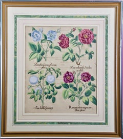
Red Roses: A Framed 17th C. Hand-colored Botanical Engraving by Basilius Besler
Located in Alamo, CA
"Rosa ex rubro nigricans" (Red Roses); a hand-colored copper engraving from Basilius Besler's landmark work, Hortus Eystettensis (Garden at Eichstatt), first published in 1613 in Eichstatt, Germany near Nuremberg and later in 1640 and 1713.
This engraving is presented in a glossy silver and matte gold-colored wood frame with a green edge and an elaborate double cream-colored French mats with light mauve bands; each accented by a broad decorative marbleized green band. It is glazed with plexiglass. There is text offset and a very small crease in the left margin, but the print is otherwise in excellent condition. Provenance: W. Graham Arader Gallery...
Category
17th Century Old Masters Landscape Prints
Materials
Engraving
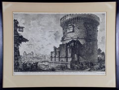
Ancient Roman Architecture: Original Framed 18th C. Etching by G. Piranesi
By Giovanni Battista Piranesi
Located in Alamo, CA
"Veduta del Sepolcro della Famiglia Plauzia per la Strada Che Conduce da Roma a Tivoli vicino a Ponte Lugano" from "Le Antichità Romane" (Roman Antiquities), one of the most famous works by Piranesi. "Antichita" illustrates the tombs along the Appian Way...
Category
Early 18th Century Old Masters Figurative Prints
Materials
Etching, Engraving, Drypoint
View of Venice, including Gondolas, 18th Century Hand Colored Engraving
By Pieter Van Der Aa
Located in Alamo, CA
An early 18th century hand colored engraving of a scene of the city of Venice, Italy entitled "Palazzo Lin, a. S. Samuele sopra il Canal Grande". It depicts Venetian architecture, wa...
Category
1720s Old Masters Landscape Prints
Materials
Engraving
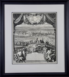
Daniel Marot's The Siege of the Dutch Fortified City of Ypres by Louis XIV
By Daniel Marot
Located in Alamo, CA
"Ypres, Grand Ville Riche & Marchande" is an engraving and etching by Daniel Marot (le Vieux) (1661–1752). It depicts a view of the siege of the city of Ypres and its citadel on the left in the Spanish Netherlands by Louis XIV's troops. This battle took place between March 18 and March 25, 1678, as part of the Franco-Dutch War. Marot illustrated in great detail (best appreciated with magnification) the French attack on the strong pentagonal citadel on the extreme left, which had been built recently in anticipation of a French attack. The trenches built by the French approaching the town are seen on the right. King Louis XIV can be seen in the foreground surveying the battle mounted on his white horse, surrounded by his officers and troops.
The print is presented in an attractive ornate black wood frame with a cream-colored double mat with a black inner trim. It is glazed with plexiglas. The frame measures 25.38" x 22.63" x .88". The engraving, frame, mat and glazing are in excellent condition.
Artist: Daniel Marot (1661–1752) was also called "Le Vieux". He was the son of the famous architect, Jean Marot. Marot had diverse interests and talents. In addition to his art, he designed garden projects, architectural ornaments, furniture, and even upholstery. Marot as a Huguenot protestant was forced to leave France in 1685 following the revocation of the Edict of Nantes. He emigrated to Holland, where he worked for William of Orange (an arch enemy of his former employer Louis XIV). Marot was largely responsible for the interiors of Williams palace at the Loo. In 1694 he went Britain as William had married Queen Mary and he had become King William III of England. He later returned to Holland in about 1698 and died in the Hague in 1752. He left a lasting legacy on the decorative arts in the Netherlands, where his grand version of the Louis XIV style remained popular into the 1730s.
Historical Background: In October 1677, Mary Stuart, niece and possible successor of Charles II of England, married Louis XIV's arch enemy William III of Orange...
Category
Late 17th Century Old Masters Landscape Prints
Materials
Engraving, Etching
$1,020 Sale Price
20% Off
Still Thinking About These?
All Recently ViewedMore Ways To Browse
Matthaus Merian The Elder
Used Watch Lot
Van Gogh Signed
Vanderbilt Collection
Victorian Birds Painting
Vintage Hillman
Vintage Pool Signs
Virgin And Child Painting
Wayang Golek
19th Century Chinese School
Altarpiece Painting
Antique Wayang Golek Puppets
Betsy Brown
Bronze Balloon
Cinque Terre
Clay Sculpture Nude
Contemporary Bronze Bust
Cupid Oil On Canvas